

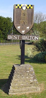
West Walton
Encyclopedia
England
England is a country that is part of the United Kingdom. It shares land borders with Scotland to the north and Wales to the west; the Irish Sea is to the north west, the Celtic Sea to the south west, with the North Sea to the east and the English Channel to the south separating it from continental...
county
County
A county is a jurisdiction of local government in certain modern nations. Historically in mainland Europe, the original French term, comté, and its equivalents in other languages denoted a jurisdiction under the sovereignty of a count A county is a jurisdiction of local government in certain...
of Norfolk
Norfolk
Norfolk is a low-lying county in the East of England. It has borders with Lincolnshire to the west, Cambridgeshire to the west and southwest and Suffolk to the south. Its northern and eastern boundaries are the North Sea coast and to the north-west the county is bordered by The Wash. The county...
The village is 56.5 miles (90.9 km) west of Norwich
Norwich
Norwich is a city in England. It is the regional administrative centre and county town of Norfolk. During the 11th century, Norwich was the largest city in England after London, and one of the most important places in the kingdom...
, 13.9 miles (22.4 km) west-south-west of King's Lynn
King's Lynn
King's Lynn is a sea port and market town in the ceremonial county of Norfolk in the East of England. It is situated north of London and west of Norwich. The population of the town is 42,800....
and 105 miles (169 km) north of London
London
London is the capital city of :England and the :United Kingdom, the largest metropolitan area in the United Kingdom, and the largest urban zone in the European Union by most measures. Located on the River Thames, London has been a major settlement for two millennia, its history going back to its...
. The nearest town is Wisbech
Wisbech
Wisbech is a market town, inland port and civil parish with a population of 20,200 in the Fens of Cambridgeshire. The tidal River Nene runs through the centre of the town and is spanned by two bridges...
which is 2.6 miles (4.2 km) south of the village. The nearest railway station is at Watlington, Norfolk
Watlington, Norfolk
Watlington is a civil parish in the English county of Norfolk.It covers an area of and had a population of 2,031 in 852 households as of the 2001 census.For the purposes of local government, it falls within the district of King's Lynn and West Norfolk....
for the Fen Line
Fen Line
The Fen Line is a railway in the United Kingdom that runs between the cities of Cambridge, Cambridgeshire and King's Lynn, Norfolk; the line is so called because it runs through The Fens. The line is part of the Network Rail Strategic Route 5 and comprises SRS 05.06 and part of 05.05...
which runs between King's Lynn
King's Lynn
King's Lynn is a sea port and market town in the ceremonial county of Norfolk in the East of England. It is situated north of London and west of Norwich. The population of the town is 42,800....
and Cambridge
Cambridge
The city of Cambridge is a university town and the administrative centre of the county of Cambridgeshire, England. It lies in East Anglia about north of London. Cambridge is at the heart of the high-technology centre known as Silicon Fen – a play on Silicon Valley and the fens surrounding the...
. The nearest airport is Norwich International Airport
Norwich International Airport
Norwich International Airport , also known as Norwich Airport, is an airport in the City of Norwich within Norfolk, England north of the city centre and on the edge of the city's suburbs....
. The parish of West Walton, in the 2001 census
United Kingdom Census 2001
A nationwide census, known as Census 2001, was conducted in the United Kingdom on Sunday, 29 April 2001. This was the 20th UK Census and recorded a resident population of 58,789,194....
, has a population of 1659. For the purposes of local government, the parish falls within the district
Non-metropolitan district
Non-metropolitan districts, or colloquially shire districts, are a type of local government district in England. As created, they are sub-divisions of non-metropolitan counties in a so-called "two-tier" arrangement...
of King's Lynn and West Norfolk
King's Lynn and West Norfolk
King's Lynn and West Norfolk is a local government district and borough in Norfolk, England. Its council is based in the town of King's Lynn.-History:...
.
Description
The village and parish of West Walton is located in the western part of the county of Norfolk. The western flank of the parish is also the county border between Norfolk and CambridgeshireCambridgeshire
Cambridgeshire is a county in England, bordering Lincolnshire to the north, Norfolk to the northeast, Suffolk to the east, Essex and Hertfordshire to the south, and Bedfordshire and Northamptonshire to the west...
and is also the course of the River Nene
River Nene
The River Nene is a river in the east of England that rises from three sources in the county of Northamptonshire. The tidal river forms the border between Cambridgeshire and Norfolk for about . It is the tenth longest river in the United Kingdom, and is navigable for from Northampton to The...
. On the southern flank is the parish of Walsoken
Walsoken
Walsoken is a village and a civil parish in the English county of Norfolk. The village is west of Norwich, west-south-west of King's Lynn and north of London. The nearest town is Wisbech which is east-north-east of the village. The Village straddles the route of the B198 which was the old A47...
. To the north is Walpole
Walpole, Norfolk
Walpole is a civil parish in the English county of Norfolk.It covers an area of , including the villages of Walpole St. Peter and Walpole St. Andrew, and had a population of 1,707 in 654 households as of the 2001 census....
and to the east is Marshland St James
Marshland St James
Marshland St James is a civil parish in the English county of Norfolk.It covers an area of and had a population of 1,137 in 456 households as of the 2001 census....
. The name West Walton is thought to derive from the Old English meaning of the settlement by the wall which refers to the villages proximity to a Roman
Roman Britain
Roman Britain was the part of the island of Great Britain controlled by the Roman Empire from AD 43 until ca. AD 410.The Romans referred to the imperial province as Britannia, which eventually comprised all of the island of Great Britain south of the fluid frontier with Caledonia...
sea wall or defence.
History
West Walton was established by the time of the Norman Conquest. The villages population, land ownership and productive resources were detailed in its entry in the Domesday BookDomesday Book
Domesday Book , now held at The National Archives, Kew, Richmond upon Thames in South West London, is the record of the great survey of much of England and parts of Wales completed in 1086...
of 1085. In the great book West Walton is recorded by the name Waltuna. The parish was held by William de Warenne
William de Warenne, 1st Earl of Surrey
William de Warenne, 1st Earl of Surrey, Seigneur de Varennes is one of the very few proven Companions of William the Conqueror known to have fought at the Battle of Hastings in 1066...
with the Abbot of St peter and St Paul, Cluny from him, The Abbot of Ely before and after 1066, and Oder from Ralph de Beufour. The survey mentions ½ Church, 38 Salt Houses and 1100 sheep. the survey also records the presence of a fishery
Fishery
Generally, a fishery is an entity engaged in raising or harvesting fish which is determined by some authority to be a fishery. According to the FAO, a fishery is typically defined in terms of the "people involved, species or type of fish, area of water or seabed, method of fishing, class of boats,...
. In the Domesday survey fractions were used to indicate that the entry, in this case the church, was situated within more than one parish.
Saint Mary Parish Church
Saint Mary's dates from the 13th century built about 1240 and is unusual in that the church's CampanileCampanile
Campanile is an Italian word meaning "bell tower" . The term applies to bell towers which are either part of a larger building or free-standing, although in American English, the latter meaning has become prevalent.The most famous campanile is probably the Leaning Tower of Pisa...
, or Bell tower is detached some 60 feet from the main building of the church. The tower is supported at its base by four open arches. At each corner stands a buttress which climb to the pinnacles with gabled niches in the first, second and third storey. The tower is topped with delicately carved parapet walls. The west doorway to the church is flanked on either side by massive buttresses, a result of remedial works carried out here after the foundations failed not long after the church was built. The south porch is arched with arcaded buttress on each side. The nave is arcaded with six bays on each side. The arches are supported on pillars which are encircled by detached shafts crowned with capitals of stone carved foliage. The hammer beamed roof dates from the 15th century and is supported by 24 carved angels holding shields.
The bell tower, and the church itself, have been separately designated by English Heritage
English Heritage
English Heritage . is an executive non-departmental public body of the British Government sponsored by the Department for Culture, Media and Sport...
as Grade I listed buildings. The bell tower is under the care of the Churches Conservation Trust
Churches Conservation Trust
The Churches Conservation Trust, which was initially known as the Redundant Churches Fund, is a charity whose purpose is to protect historic churches at risk, those that have been made redundant by the Church of England. The Trust was established by the Pastoral Measure of 1968...
.