

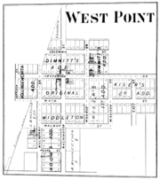
West Point, Indiana
Encyclopedia
West Point is a small town in Tippecanoe County
, Indiana
. It is part of the Lafayette, Indiana
Metropolitan Statistical Area
. It had a population of 594 at the 2010 census.
 West Point is located at 40°20'42" North, 87°02'35" West (40.345036, -87.043066) along State Road 25
at an elevation of approximately 673 feet. The town is in Wayne Township
and sits about a quarter of a mile north of Flint Creek which flows west to the Wabash River
.
A village named Glen Hall
existed on the north side of West Point in the 19th century; though still populated, the site is now generally considered part of West Point.
Tippecanoe County, Indiana
Tippecanoe County is a county located in the northwest quadrant of the U.S. state of Indiana. It was created in 1826 from Wabash County. It is part of the Lafayette, Indiana, Metropolitan Statistical Area....
, Indiana
Indiana
Indiana is a US state, admitted to the United States as the 19th on December 11, 1816. It is located in the Midwestern United States and Great Lakes Region. With 6,483,802 residents, the state is ranked 15th in population and 16th in population density. Indiana is ranked 38th in land area and is...
. It is part of the Lafayette, Indiana
Lafayette, Indiana
Lafayette is a city in and the county seat of Tippecanoe County, Indiana, United States, northwest of Indianapolis. As of the 2010 census, the city had a total population of 67,140. West Lafayette, on the other side of the Wabash River, is home to Purdue University, which has a large impact on...
Metropolitan Statistical Area
Lafayette, Indiana metropolitan area
The Lafayette, Indiana Metropolitan Statistical Area, as defined by the United States Census Bureau, is an area consisting of three counties in Indiana, anchored by the city of Lafayette...
. It had a population of 594 at the 2010 census.
Geography
Indiana State Road 25
State Road 25 is a highway in the U. S. state of Indiana. Although it is designated a north–south road, in practice it travels generally northeast from its southern terminus at State Road 32 to its northern terminus at State Road 15 in Warsaw.- Waynetown to Lafayette :SR 25 heads north...
at an elevation of approximately 673 feet. The town is in Wayne Township
Wayne Township, Tippecanoe County, Indiana
Wayne Township is one of thirteen townships in Tippecanoe County, Indiana, USA. As of the 2000 census, its population was 1,306.-Geography:According to the United States Census Bureau, Wayne Township covers an area of ; of this, or 1.02 percent is water....
and sits about a quarter of a mile north of Flint Creek which flows west to the Wabash River
Wabash River
The Wabash River is a river in the Midwestern United States that flows southwest from northwest Ohio near Fort Recovery across northern Indiana to southern Illinois, where it forms the Illinois-Indiana border before draining into the Ohio River, of which it is the largest northern tributary...
.
A village named Glen Hall
Glen Hall, Indiana
Glen Hall is a small settlement in Wayne Township, Tippecanoe County, Indiana. The site is often considered part of the adjoining town of West Point.- Geography :...
existed on the north side of West Point in the 19th century; though still populated, the site is now generally considered part of West Point.