
Wernigerode
Encyclopedia
Wernigerode (ˌvɛɐ̯nɪɡəˈʁoːdə) is a town
in the district of Harz
, Saxony-Anhalt
, Germany
. Until 2007, it was the capital of the district of Wernigerode
. Its population was 35,500 in 1999.
Wernigerode is located southwest of Halberstadt
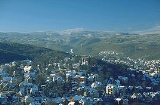
, and is picturesquely situated on the Holtemme
river, on the north slopes of the Harz Mountains. Wernigerode is located on the German Half-Timbered House Road.
, at the foot of their highest peak, the Brocken, on the B 6
and B 244
federal highways and on the railway line from Halberstadt to Vienenburg
that links the cities of Halle (Saale) and Hanover
.
The River Holtemme flows through the town and, not far from its western gate, it is joined by the Zillierbach
stream, which is also known as the Flutrenne near its mouth. North of the town the Barrenbach flows through several ponds and empties into the Holtemme in the village of Minsleben. The historic town centre consists of an old town
and a new town
(Altstadt and Neustadt). The town's borough includes Hasserode
, Nöschenrode, the residential estates of Stadtfeld, Burgbreite and Harzblick as well as the villages of Benzingerode
, Minsleben, Silstedt, Schierke
and Reddeber
.
The borough measures 9.5 km from west to east and 6 km from north to south. Its highest point is the Brocken, at 1,141 metres above NN, and its lowest is at 215 metres.
The town lies on the German-Dutch holiday road known as the Orange Route
.
The Northern Harz Boundary Fault
crosses the borough along which the watershed between the Weser and Elbe runs. To the north precipitation flows into the Weser, to the southeast, later northeast, waters flow into the Elbe. This fault line runs through the quarter of Hasserode. It can be made out in the east of the town at the Schloßberg.
The North Harz Fault cuts through the borough along which the watershed between Weser and Elbe rivers runs. To the north of the fault line, the precipitation flows into the Weser; to the southeast, later northeast, waters flow into the Elbe. This fault runs through the suburb of Hasserode. To the east it is manifested in the town's castle hill.
and Nöschenrode incorporated before 1994 and five villages with their own parish councils that were integrated in 1994: Benzingerode
, Minsleben, Reddeber
, Schierke
and Silstedt.
The warmest months are June to August with average temperatures of 16.0 to 18.3 ºC and the coldest are December to February at 1.1 to 2.1 ºC.
The most rain falls in July, on average 54 millimetres, the least in February, with 30 millimetres on average.
The climate, more precisely the amounts of precipitation and temperatures, are influenced by the orographic rainfall caused by the Harz Mountains. Because the town lies in the rain shadow (leeward side) of the Harz, less precipitation falls here than in similar temperate regions without the protection of a mountain range. In addition the occasional föhn winds that occur result in an increase in temperatures.
Wernigerode has a snow load class of 3 according to the German industrial standard, DIN 1055.
and Stolberg-Wernigerode
. In 1815, after the Napoleonic Wars
, it became part of the Prussia
n Province of Saxony
. The Hasseröder
brewery was founded in Wernigerode in 1872.
After World War II
, Wernigerode was included in the new state Saxony-Anhalt
. During the time of Communist East Germany, the town was very close to the inner German border. Wernigerode became part of the restored state of Saxony-Anhalt in 1990 after German reunification
.
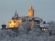
The first area to be settle was the Klint, where there was a lowland castle
, the so-called Schnakenburg. In 1805 the ruins of this castle site were demolished. The only part remaining is Haus Gadenstedt at Oberpfarrkirchhof 12 which dates to the year 1582. At the time of the first settlelement there was still ancient forest, typical of the Harz, on the heights of the Klint, which had first to be cleared, hence the suffix -rode in the town name which means "clearing".
The town was first mentioned in the records in 1121 in connexion with Count Adalbert of Haimar who had moved here from the region near Hildesheim
and henceforth was titled the Count of Wernigerode. On 17 April 1229 the settlement was granted town rights along the lines of that for Goslar
. In 2004 Wernigerode celebrated the 775th anniversary of that occasion.
As a result of the immigration of new townsfolk from the surrounding villages a new settlement, later called Neustadt, grew up on the northeastern edge of the old town. It was a farming settlement that lay outside the walls of the old town. St. John's Church was built as the parish church of Wernigerode's Neustadt in the last third of the 13th century in the Romanesque
style.
Wernigerode (ˌvɛɐ̯nɪɡəˈʁoːdə) is a town
in the district of Harz
, Saxony-Anhalt
, Germany
. Until 2007, it was the capital of the district of Wernigerode
. Its population was 35,500 in 1999.
Wernigerode is located southwest of Halberstadt
, and is picturesquely situated on the Holtemme
river, on the north slopes of the Harz Mountains. Wernigerode is located on the German Half-Timbered House Road.
, at the foot of their highest peak, the Brocken, on the B 6
and B 244
federal highways and on the railway line from Halberstadt to Vienenburg
that links the cities of Halle (Saale) and Hanover
.
The River Holtemme flows through the town and, not far from its western gate, it is joined by the Zillierbach
stream, which is also known as the Flutrenne near its mouth. North of the town the Barrenbach flows through several ponds and empties into the Holtemme in the village of Minsleben. The historic town centre consists of an old town
and a new town
(Altstadt and Neustadt). The town's borough includes Hasserode
, Nöschenrode, the residential estates of Stadtfeld, Burgbreite and Harzblick as well as the villages of Benzingerode
, Minsleben, Silstedt, Schierke
and Reddeber
.
The borough measures 9.5 km from west to east and 6 km from north to south. Its highest point is the Brocken, at 1,141 metres above NN, and its lowest is at 215 metres.
The town lies on the German-Dutch holiday road known as the Orange Route
.
The Northern Harz Boundary Fault
crosses the borough along which the watershed between the Weser and Elbe runs. To the north precipitation flows into the Weser, to the southeast, later northeast, waters flow into the Elbe. This fault line runs through the quarter of Hasserode. It can be made out in the east of the town at the Schloßberg.
The North Harz Fault cuts through the borough along which the watershed between Weser and Elbe rivers runs. To the north of the fault line, the precipitation flows into the Weser; to the southeast, later northeast, waters flow into the Elbe. This fault runs through the suburb of Hasserode. To the east it is manifested in the town's castle hill.
and Nöschenrode incorporated before 1994 and five villages with their own parish councils that were integrated in 1994: Benzingerode
, Minsleben, Reddeber
, Schierke
and Silstedt.
The warmest months are June to August with average temperatures of 16.0 to 18.3 ºC and the coldest are December to February at 1.1 to 2.1 ºC.
The most rain falls in July, on average 54 millimetres, the least in February, with 30 millimetres on average.
The climate, more precisely the amounts of precipitation and temperatures, are influenced by the orographic rainfall caused by the Harz Mountains. Because the town lies in the rain shadow (leeward side) of the Harz, less precipitation falls here than in similar temperate regions without the protection of a mountain range. In addition the occasional föhn winds that occur result in an increase in temperatures.
Wernigerode has a snow load class of 3 according to the German industrial standard, DIN 1055.
and Stolberg-Wernigerode
. In 1815, after the Napoleonic Wars
, it became part of the Prussia
n Province of Saxony
. The Hasseröder
brewery was founded in Wernigerode in 1872.
After World War II
, Wernigerode was included in the new state Saxony-Anhalt
. During the time of Communist East Germany, the town was very close to the inner German border. Wernigerode became part of the restored state of Saxony-Anhalt in 1990 after German reunification
.
The first area to be settle was the Klint, where there was a lowland castle
, the so-called Schnakenburg. In 1805 the ruins of this castle site were demolished. The only part remaining is Haus Gadenstedt at Oberpfarrkirchhof 12 which dates to the year 1582. At the time of the first settlelement there was still ancient forest, typical of the Harz, on the heights of the Klint, which had first to be cleared, hence the suffix -rode in the town name which means "clearing".
The town was first mentioned in the records in 1121 in connexion with Count Adalbert of Haimar who had moved here from the region near Hildesheim
and henceforth was titled the Count of Wernigerode. On 17 April 1229 the settlement was granted town rights along the lines of that for Goslar
. In 2004 Wernigerode celebrated the 775th anniversary of that occasion.
As a result of the immigration of new townsfolk from the surrounding villages a new settlement, later called Neustadt, grew up on the northeastern edge of the old town. It was a farming settlement that lay outside the walls of the old town. St. John's Church was built as the parish church of Wernigerode's Neustadt in the last third of the 13th century in the Romanesque
style.

Town
A town is a human settlement larger than a village but smaller than a city. The size a settlement must be in order to be called a "town" varies considerably in different parts of the world, so that, for example, many American "small towns" seem to British people to be no more than villages, while...
in the district of Harz
Harz (district)
- History :The district was established by merging the former districts of Halberstadt, Wernigerode and Quedlinburg as well as the city of Falkenstein as part of the reform of 2007.-Towns and municipalities:...
, Saxony-Anhalt
Saxony-Anhalt
Saxony-Anhalt is a landlocked state of Germany. Its capital is Magdeburg and it is surrounded by the German states of Lower Saxony, Brandenburg, Saxony, and Thuringia.Saxony-Anhalt covers an area of...
, Germany
Germany
Germany , officially the Federal Republic of Germany , is a federal parliamentary republic in Europe. The country consists of 16 states while the capital and largest city is Berlin. Germany covers an area of 357,021 km2 and has a largely temperate seasonal climate...
. Until 2007, it was the capital of the district of Wernigerode
Wernigerode (district)
Wernigerode was a district in the west of Saxony-Anhalt, Germany. Neighboring districts are Halberstadt, Quedlinburg, the district Nordhausen in Thuringia and the district Goslar in Lower Saxony.- Geography :...
. Its population was 35,500 in 1999.
Wernigerode is located southwest of Halberstadt
Halberstadt
Halberstadt is a town in the German state of Saxony-Anhalt and the capital of the district of Harz. It is located on the German Half-Timbered House Road and the Magdeburg–Thale railway....
, and is picturesquely situated on the Holtemme
Holtemme
The Holtemme is a 47 km long tributary of the river Bode in Saxony-Anhalt, Germany.It rises in the Harz mountains at the eastern foot of the Brocken, descends during its upper course as the Steinerne Renne, a steep stream bed riddled with granite rocks, flows through Hasserode, Wernigerode and past...
river, on the north slopes of the Harz Mountains. Wernigerode is located on the German Half-Timbered House Road.
Location
The town lies at about 250 metres above sea level (NN) on the northeastern flank of the Harz Mountains in central GermanyGermany
Germany , officially the Federal Republic of Germany , is a federal parliamentary republic in Europe. The country consists of 16 states while the capital and largest city is Berlin. Germany covers an area of 357,021 km2 and has a largely temperate seasonal climate...
, at the foot of their highest peak, the Brocken, on the B 6
Bundesstraße 6
The Bundesstraße 6 runs from the North Sea coast in a southeasterly direction through the states of Lower Saxony, Bremen, Saxony-Anhalt and Saxony to the Polish border.- History :...
and B 244
Bundesstraße 244
Bundesstraße 244 is a federal road in Germany that branches off the B 4 west of Dedelstorf towards the east and runs through Wittingen, Brome, Rühen, Velpke, Helmstedt, Schöningen, Dardesheim, Wernigerode to Elbingerode, where it ends at the B 27....
federal highways and on the railway line from Halberstadt to Vienenburg
Halberstadt–Vienenburg railway
The Halberstadt–Vienenburg railway is a 34 kilometre long main line north of the Harz Mountains in central Germany. The line was opened in 1869, but only the section between Halberstadt and Heudeber-Danstedt and a 3 kilometre long section of the line near Vienenburg are still worked. Both...
that links the cities of Halle (Saale) and Hanover
Hanover
Hanover or Hannover, on the river Leine, is the capital of the federal state of Lower Saxony , Germany and was once by personal union the family seat of the Hanoverian Kings of Great Britain, under their title as the dukes of Brunswick-Lüneburg...
.
The River Holtemme flows through the town and, not far from its western gate, it is joined by the Zillierbach
Zillierbach
The Zillierbach is a stream in the Harz mountains of central Germany The Zillierbach (until 1558 called the Zilgerbach) is a stream in the Harz mountains of central Germany The Zillierbach (until 1558 called the Zilgerbach) is a stream in the Harz mountains of central Germany (Harz district in the...
stream, which is also known as the Flutrenne near its mouth. North of the town the Barrenbach flows through several ponds and empties into the Holtemme in the village of Minsleben. The historic town centre consists of an old town
Old Town
Old Town is the typical designation of a historic or original core of a city or town. Although the city may be larger in its present form, many cities have redesignated this part of the city to commemorate its origins after thorough renovations...
and a new town
New town
A new town is a specific type of a planned community, or planned city, that was carefully planned from its inception and is typically constructed in a previously undeveloped area. This contrasts with settlements that evolve in a more ad hoc fashion. Land use conflicts are uncommon in new...
(Altstadt and Neustadt). The town's borough includes Hasserode
Hasserode
Hasserode has been a quarter in the town of Wernigerode since 1907, a town in the German state of Saxony-Anhalt.- Location :Hasserode lies at the foot of the Harz Mountains in the valley of the River Holtemme, whose upper reaches include the water cascade of the Steinerne Renne...
, Nöschenrode, the residential estates of Stadtfeld, Burgbreite and Harzblick as well as the villages of Benzingerode
Benzingerode
Benzingerode has been a village incorporated into the borough of Wernigerode since 1 April 1993. in the district of Harz in the German state of Saxony-Anhalt.- Location :...
, Minsleben, Silstedt, Schierke
Schierke
Schierke is a village and a former municipality in the Harz district, in the German state of Saxony-Anhalt. Since 1 July 2009, it is part of the town Wernigerode.Schierke was first mentioned as Schiriken in a 1590 deed...
and Reddeber
Reddeber
Reddeber is a village and a former municipality in the district of Harz, in Saxony-Anhalt, Germany. Since 1 January 2011, it is part of the town Wernigerode....
.
The borough measures 9.5 km from west to east and 6 km from north to south. Its highest point is the Brocken, at 1,141 metres above NN, and its lowest is at 215 metres.
The town lies on the German-Dutch holiday road known as the Orange Route
Orange Route
The Orange Route is a holiday route, that runs from Amsterdam in the Netherlands through North and Central Germany and returns to Amsterdam. It is 2,400 kilometres long and crossess the Netherlands and nine German federal states...
.
The Northern Harz Boundary Fault
Northern Harz Boundary Fault
The Northern Harz Boundary Fault is a geological fault where the Harz Block, which consists of rocks formed during the Palaeozoic Era and folded in the course of Hercynian mountain building, borders on the Subhercynian Basin or Harz Foreland...
crosses the borough along which the watershed between the Weser and Elbe runs. To the north precipitation flows into the Weser, to the southeast, later northeast, waters flow into the Elbe. This fault line runs through the quarter of Hasserode. It can be made out in the east of the town at the Schloßberg.
The North Harz Fault cuts through the borough along which the watershed between Weser and Elbe rivers runs. To the north of the fault line, the precipitation flows into the Weser; to the southeast, later northeast, waters flow into the Elbe. This fault runs through the suburb of Hasserode. To the east it is manifested in the town's castle hill.
Town divisions
The borough of Wernigerode is divided into the town itself, including the villages of HasserodeHasserode
Hasserode has been a quarter in the town of Wernigerode since 1907, a town in the German state of Saxony-Anhalt.- Location :Hasserode lies at the foot of the Harz Mountains in the valley of the River Holtemme, whose upper reaches include the water cascade of the Steinerne Renne...
and Nöschenrode incorporated before 1994 and five villages with their own parish councils that were integrated in 1994: Benzingerode
Benzingerode
Benzingerode has been a village incorporated into the borough of Wernigerode since 1 April 1993. in the district of Harz in the German state of Saxony-Anhalt.- Location :...
, Minsleben, Reddeber
Reddeber
Reddeber is a village and a former municipality in the district of Harz, in Saxony-Anhalt, Germany. Since 1 January 2011, it is part of the town Wernigerode....
, Schierke
Schierke
Schierke is a village and a former municipality in the Harz district, in the German state of Saxony-Anhalt. Since 1 July 2009, it is part of the town Wernigerode.Schierke was first mentioned as Schiriken in a 1590 deed...
and Silstedt.
Climate
Wernigerode is located in the Central European transition subzone of the temperate climatic zone. Its average annual temperature is 9.5 ºC; its average annual precipitation is 500 millimetres.The warmest months are June to August with average temperatures of 16.0 to 18.3 ºC and the coldest are December to February at 1.1 to 2.1 ºC.
The most rain falls in July, on average 54 millimetres, the least in February, with 30 millimetres on average.
The climate, more precisely the amounts of precipitation and temperatures, are influenced by the orographic rainfall caused by the Harz Mountains. Because the town lies in the rain shadow (leeward side) of the Harz, less precipitation falls here than in similar temperate regions without the protection of a mountain range. In addition the occasional föhn winds that occur result in an increase in temperatures.
Wernigerode has a snow load class of 3 according to the German industrial standard, DIN 1055.
History
Wernigerode was the capital of the medieval County of WernigerodeCounty of Wernigerode
The County of Wernigerode was a county of the Holy Roman Empire, located in the Harzgau region of the former Duchy of Saxony, at the northern foot of the Harz mountain range...
and Stolberg-Wernigerode
Stolberg-Wernigerode
The Principality of Stolberg-Wernigerode was a county of the Holy Roman Empire located in the Harz region around Wernigerode, now part of Saxony-Anhalt, Germany.-History:...
. In 1815, after the Napoleonic Wars
Napoleonic Wars
The Napoleonic Wars were a series of wars declared against Napoleon's French Empire by opposing coalitions that ran from 1803 to 1815. As a continuation of the wars sparked by the French Revolution of 1789, they revolutionised European armies and played out on an unprecedented scale, mainly due to...
, it became part of the Prussia
Prussia
Prussia was a German kingdom and historic state originating out of the Duchy of Prussia and the Margraviate of Brandenburg. For centuries, the House of Hohenzollern ruled Prussia, successfully expanding its size by way of an unusually well-organized and effective army. Prussia shaped the history...
n Province of Saxony
Province of Saxony
The Province of Saxony was a province of the Kingdom of Prussia and later the Free State of Prussia from 1816 until 1945. Its capital was Magdeburg.-History:The province was created in 1816 out of the following territories:...
. The Hasseröder
Hasseröder
The Hasseröder brewery started in 1872 under the name “Zum Auerhahn,” in the district of Hasserode in Wernigerode. In 1882 Ernst Schreyer assumed control of the brewery. In 1896 the brewery became an "Aktiengesellschaft" or AG, and in the same year put out 25,000 hectoliters of beer...
brewery was founded in Wernigerode in 1872.
After World War II
World War II
World War II, or the Second World War , was a global conflict lasting from 1939 to 1945, involving most of the world's nations—including all of the great powers—eventually forming two opposing military alliances: the Allies and the Axis...
, Wernigerode was included in the new state Saxony-Anhalt
Saxony-Anhalt
Saxony-Anhalt is a landlocked state of Germany. Its capital is Magdeburg and it is surrounded by the German states of Lower Saxony, Brandenburg, Saxony, and Thuringia.Saxony-Anhalt covers an area of...
. During the time of Communist East Germany, the town was very close to the inner German border. Wernigerode became part of the restored state of Saxony-Anhalt in 1990 after German reunification
German reunification
German reunification was the process in 1990 in which the German Democratic Republic joined the Federal Republic of Germany , and when Berlin reunited into a single city, as provided by its then Grundgesetz constitution Article 23. The start of this process is commonly referred by Germans as die...
.
Emergence of the town
There are no written sources confirming exactly when the town was established. According to the latest research – for example, by Eduard Jacobs and Walther Grosse – there were no early relations with the Abbey at Corvey (Weser) and the abbot there, Warin, instead the town name suggests it was a protected clearance settlement.The first area to be settle was the Klint, where there was a lowland castle
Lowland castle
The term lowland castle or plains castle describes a type of castle based that is situated on a lowland, plain or valley floor, as opposed to one built on higher ground such as a hill spur...
, the so-called Schnakenburg. In 1805 the ruins of this castle site were demolished. The only part remaining is Haus Gadenstedt at Oberpfarrkirchhof 12 which dates to the year 1582. At the time of the first settlelement there was still ancient forest, typical of the Harz, on the heights of the Klint, which had first to be cleared, hence the suffix -rode in the town name which means "clearing".
The town was first mentioned in the records in 1121 in connexion with Count Adalbert of Haimar who had moved here from the region near Hildesheim
Hildesheim
Hildesheim is a city in Lower Saxony, Germany. It is located in the district of Hildesheim, about 30 km southeast of Hanover on the banks of the Innerste river, which is a small tributary of the Leine river...
and henceforth was titled the Count of Wernigerode. On 17 April 1229 the settlement was granted town rights along the lines of that for Goslar
Goslar
Goslar is a historic town in Lower Saxony, Germany. It is the administrative centre of the district of Goslar and located on the northwestern slopes of the Harz mountain range. The Old Town of Goslar and the Mines of Rammelsberg are UNESCO World Heritage Sites.-Geography:Goslar is situated at the...
. In 2004 Wernigerode celebrated the 775th anniversary of that occasion.
As a result of the immigration of new townsfolk from the surrounding villages a new settlement, later called Neustadt, grew up on the northeastern edge of the old town. It was a farming settlement that lay outside the walls of the old town. St. John's Church was built as the parish church of Wernigerode's Neustadt in the last third of the 13th century in the Romanesque
Romanesque
Romanesque may refer to:*Romanesque art, the art of Western Europe from approximately AD 1000 to the 13th century or later*Romanesque architecture, architecture of Europe which emerged in the late 10th century and lasted to the 13th century...
style.
Wernigerode (ˌvɛɐ̯nɪɡəˈʁoːdə) is a town
Town
A town is a human settlement larger than a village but smaller than a city. The size a settlement must be in order to be called a "town" varies considerably in different parts of the world, so that, for example, many American "small towns" seem to British people to be no more than villages, while...
in the district of Harz
Harz (district)
- History :The district was established by merging the former districts of Halberstadt, Wernigerode and Quedlinburg as well as the city of Falkenstein as part of the reform of 2007.-Towns and municipalities:...
, Saxony-Anhalt
Saxony-Anhalt
Saxony-Anhalt is a landlocked state of Germany. Its capital is Magdeburg and it is surrounded by the German states of Lower Saxony, Brandenburg, Saxony, and Thuringia.Saxony-Anhalt covers an area of...
, Germany
Germany
Germany , officially the Federal Republic of Germany , is a federal parliamentary republic in Europe. The country consists of 16 states while the capital and largest city is Berlin. Germany covers an area of 357,021 km2 and has a largely temperate seasonal climate...
. Until 2007, it was the capital of the district of Wernigerode
Wernigerode (district)
Wernigerode was a district in the west of Saxony-Anhalt, Germany. Neighboring districts are Halberstadt, Quedlinburg, the district Nordhausen in Thuringia and the district Goslar in Lower Saxony.- Geography :...
. Its population was 35,500 in 1999.
Wernigerode is located southwest of Halberstadt
Halberstadt
Halberstadt is a town in the German state of Saxony-Anhalt and the capital of the district of Harz. It is located on the German Half-Timbered House Road and the Magdeburg–Thale railway....
, and is picturesquely situated on the Holtemme
Holtemme
The Holtemme is a 47 km long tributary of the river Bode in Saxony-Anhalt, Germany.It rises in the Harz mountains at the eastern foot of the Brocken, descends during its upper course as the Steinerne Renne, a steep stream bed riddled with granite rocks, flows through Hasserode, Wernigerode and past...
river, on the north slopes of the Harz Mountains. Wernigerode is located on the German Half-Timbered House Road.
Location
The town lies at about 250 metres above sea level (NN) on the northeastern flank of the Harz Mountains in central GermanyGermany
Germany , officially the Federal Republic of Germany , is a federal parliamentary republic in Europe. The country consists of 16 states while the capital and largest city is Berlin. Germany covers an area of 357,021 km2 and has a largely temperate seasonal climate...
, at the foot of their highest peak, the Brocken, on the B 6
Bundesstraße 6
The Bundesstraße 6 runs from the North Sea coast in a southeasterly direction through the states of Lower Saxony, Bremen, Saxony-Anhalt and Saxony to the Polish border.- History :...
and B 244
Bundesstraße 244
Bundesstraße 244 is a federal road in Germany that branches off the B 4 west of Dedelstorf towards the east and runs through Wittingen, Brome, Rühen, Velpke, Helmstedt, Schöningen, Dardesheim, Wernigerode to Elbingerode, where it ends at the B 27....
federal highways and on the railway line from Halberstadt to Vienenburg
Halberstadt–Vienenburg railway
The Halberstadt–Vienenburg railway is a 34 kilometre long main line north of the Harz Mountains in central Germany. The line was opened in 1869, but only the section between Halberstadt and Heudeber-Danstedt and a 3 kilometre long section of the line near Vienenburg are still worked. Both...
that links the cities of Halle (Saale) and Hanover
Hanover
Hanover or Hannover, on the river Leine, is the capital of the federal state of Lower Saxony , Germany and was once by personal union the family seat of the Hanoverian Kings of Great Britain, under their title as the dukes of Brunswick-Lüneburg...
.
The River Holtemme flows through the town and, not far from its western gate, it is joined by the Zillierbach
Zillierbach
The Zillierbach is a stream in the Harz mountains of central Germany The Zillierbach (until 1558 called the Zilgerbach) is a stream in the Harz mountains of central Germany The Zillierbach (until 1558 called the Zilgerbach) is a stream in the Harz mountains of central Germany (Harz district in the...
stream, which is also known as the Flutrenne near its mouth. North of the town the Barrenbach flows through several ponds and empties into the Holtemme in the village of Minsleben. The historic town centre consists of an old town
Old Town
Old Town is the typical designation of a historic or original core of a city or town. Although the city may be larger in its present form, many cities have redesignated this part of the city to commemorate its origins after thorough renovations...
and a new town
New town
A new town is a specific type of a planned community, or planned city, that was carefully planned from its inception and is typically constructed in a previously undeveloped area. This contrasts with settlements that evolve in a more ad hoc fashion. Land use conflicts are uncommon in new...
(Altstadt and Neustadt). The town's borough includes Hasserode
Hasserode
Hasserode has been a quarter in the town of Wernigerode since 1907, a town in the German state of Saxony-Anhalt.- Location :Hasserode lies at the foot of the Harz Mountains in the valley of the River Holtemme, whose upper reaches include the water cascade of the Steinerne Renne...
, Nöschenrode, the residential estates of Stadtfeld, Burgbreite and Harzblick as well as the villages of Benzingerode
Benzingerode
Benzingerode has been a village incorporated into the borough of Wernigerode since 1 April 1993. in the district of Harz in the German state of Saxony-Anhalt.- Location :...
, Minsleben, Silstedt, Schierke
Schierke
Schierke is a village and a former municipality in the Harz district, in the German state of Saxony-Anhalt. Since 1 July 2009, it is part of the town Wernigerode.Schierke was first mentioned as Schiriken in a 1590 deed...
and Reddeber
Reddeber
Reddeber is a village and a former municipality in the district of Harz, in Saxony-Anhalt, Germany. Since 1 January 2011, it is part of the town Wernigerode....
.
The borough measures 9.5 km from west to east and 6 km from north to south. Its highest point is the Brocken, at 1,141 metres above NN, and its lowest is at 215 metres.
The town lies on the German-Dutch holiday road known as the Orange Route
Orange Route
The Orange Route is a holiday route, that runs from Amsterdam in the Netherlands through North and Central Germany and returns to Amsterdam. It is 2,400 kilometres long and crossess the Netherlands and nine German federal states...
.
The Northern Harz Boundary Fault
Northern Harz Boundary Fault
The Northern Harz Boundary Fault is a geological fault where the Harz Block, which consists of rocks formed during the Palaeozoic Era and folded in the course of Hercynian mountain building, borders on the Subhercynian Basin or Harz Foreland...
crosses the borough along which the watershed between the Weser and Elbe runs. To the north precipitation flows into the Weser, to the southeast, later northeast, waters flow into the Elbe. This fault line runs through the quarter of Hasserode. It can be made out in the east of the town at the Schloßberg.
The North Harz Fault cuts through the borough along which the watershed between Weser and Elbe rivers runs. To the north of the fault line, the precipitation flows into the Weser; to the southeast, later northeast, waters flow into the Elbe. This fault runs through the suburb of Hasserode. To the east it is manifested in the town's castle hill.
Town divisions
The borough of Wernigerode is divided into the town itself, including the villages of HasserodeHasserode
Hasserode has been a quarter in the town of Wernigerode since 1907, a town in the German state of Saxony-Anhalt.- Location :Hasserode lies at the foot of the Harz Mountains in the valley of the River Holtemme, whose upper reaches include the water cascade of the Steinerne Renne...
and Nöschenrode incorporated before 1994 and five villages with their own parish councils that were integrated in 1994: Benzingerode
Benzingerode
Benzingerode has been a village incorporated into the borough of Wernigerode since 1 April 1993. in the district of Harz in the German state of Saxony-Anhalt.- Location :...
, Minsleben, Reddeber
Reddeber
Reddeber is a village and a former municipality in the district of Harz, in Saxony-Anhalt, Germany. Since 1 January 2011, it is part of the town Wernigerode....
, Schierke
Schierke
Schierke is a village and a former municipality in the Harz district, in the German state of Saxony-Anhalt. Since 1 July 2009, it is part of the town Wernigerode.Schierke was first mentioned as Schiriken in a 1590 deed...
and Silstedt.
Climate
Wernigerode is located in the Central European transition subzone of the temperate climatic zone. Its average annual temperature is 9.5 ºC; its average annual precipitation is 500 millimetres.The warmest months are June to August with average temperatures of 16.0 to 18.3 ºC and the coldest are December to February at 1.1 to 2.1 ºC.
The most rain falls in July, on average 54 millimetres, the least in February, with 30 millimetres on average.
The climate, more precisely the amounts of precipitation and temperatures, are influenced by the orographic rainfall caused by the Harz Mountains. Because the town lies in the rain shadow (leeward side) of the Harz, less precipitation falls here than in similar temperate regions without the protection of a mountain range. In addition the occasional föhn winds that occur result in an increase in temperatures.
Wernigerode has a snow load class of 3 according to the German industrial standard, DIN 1055.
History
Wernigerode was the capital of the medieval County of WernigerodeCounty of Wernigerode
The County of Wernigerode was a county of the Holy Roman Empire, located in the Harzgau region of the former Duchy of Saxony, at the northern foot of the Harz mountain range...
and Stolberg-Wernigerode
Stolberg-Wernigerode
The Principality of Stolberg-Wernigerode was a county of the Holy Roman Empire located in the Harz region around Wernigerode, now part of Saxony-Anhalt, Germany.-History:...
. In 1815, after the Napoleonic Wars
Napoleonic Wars
The Napoleonic Wars were a series of wars declared against Napoleon's French Empire by opposing coalitions that ran from 1803 to 1815. As a continuation of the wars sparked by the French Revolution of 1789, they revolutionised European armies and played out on an unprecedented scale, mainly due to...
, it became part of the Prussia
Prussia
Prussia was a German kingdom and historic state originating out of the Duchy of Prussia and the Margraviate of Brandenburg. For centuries, the House of Hohenzollern ruled Prussia, successfully expanding its size by way of an unusually well-organized and effective army. Prussia shaped the history...
n Province of Saxony
Province of Saxony
The Province of Saxony was a province of the Kingdom of Prussia and later the Free State of Prussia from 1816 until 1945. Its capital was Magdeburg.-History:The province was created in 1816 out of the following territories:...
. The Hasseröder
Hasseröder
The Hasseröder brewery started in 1872 under the name “Zum Auerhahn,” in the district of Hasserode in Wernigerode. In 1882 Ernst Schreyer assumed control of the brewery. In 1896 the brewery became an "Aktiengesellschaft" or AG, and in the same year put out 25,000 hectoliters of beer...
brewery was founded in Wernigerode in 1872.
After World War II
World War II
World War II, or the Second World War , was a global conflict lasting from 1939 to 1945, involving most of the world's nations—including all of the great powers—eventually forming two opposing military alliances: the Allies and the Axis...
, Wernigerode was included in the new state Saxony-Anhalt
Saxony-Anhalt
Saxony-Anhalt is a landlocked state of Germany. Its capital is Magdeburg and it is surrounded by the German states of Lower Saxony, Brandenburg, Saxony, and Thuringia.Saxony-Anhalt covers an area of...
. During the time of Communist East Germany, the town was very close to the inner German border. Wernigerode became part of the restored state of Saxony-Anhalt in 1990 after German reunification
German reunification
German reunification was the process in 1990 in which the German Democratic Republic joined the Federal Republic of Germany , and when Berlin reunited into a single city, as provided by its then Grundgesetz constitution Article 23. The start of this process is commonly referred by Germans as die...
.
Emergence of the town
There are no written sources confirming exactly when the town was established. According to the latest research – for example, by Eduard Jacobs and Walther Grosse – there were no early relations with the Abbey at Corvey (Weser) and the abbot there, Warin, instead the town name suggests it was a protected clearance settlement.The first area to be settle was the Klint, where there was a lowland castle
Lowland castle
The term lowland castle or plains castle describes a type of castle based that is situated on a lowland, plain or valley floor, as opposed to one built on higher ground such as a hill spur...
, the so-called Schnakenburg. In 1805 the ruins of this castle site were demolished. The only part remaining is Haus Gadenstedt at Oberpfarrkirchhof 12 which dates to the year 1582. At the time of the first settlelement there was still ancient forest, typical of the Harz, on the heights of the Klint, which had first to be cleared, hence the suffix -rode in the town name which means "clearing".
The town was first mentioned in the records in 1121 in connexion with Count Adalbert of Haimar who had moved here from the region near Hildesheim
Hildesheim
Hildesheim is a city in Lower Saxony, Germany. It is located in the district of Hildesheim, about 30 km southeast of Hanover on the banks of the Innerste river, which is a small tributary of the Leine river...
and henceforth was titled the Count of Wernigerode. On 17 April 1229 the settlement was granted town rights along the lines of that for Goslar
Goslar
Goslar is a historic town in Lower Saxony, Germany. It is the administrative centre of the district of Goslar and located on the northwestern slopes of the Harz mountain range. The Old Town of Goslar and the Mines of Rammelsberg are UNESCO World Heritage Sites.-Geography:Goslar is situated at the...
. In 2004 Wernigerode celebrated the 775th anniversary of that occasion.
As a result of the immigration of new townsfolk from the surrounding villages a new settlement, later called Neustadt, grew up on the northeastern edge of the old town. It was a farming settlement that lay outside the walls of the old town. St. John's Church was built as the parish church of Wernigerode's Neustadt in the last third of the 13th century in the Romanesque
Romanesque
Romanesque may refer to:*Romanesque art, the art of Western Europe from approximately AD 1000 to the 13th century or later*Romanesque architecture, architecture of Europe which emerged in the late 10th century and lasted to the 13th century...
style.