

Weatherford, Oklahoma
Encyclopedia
Weatherford is a city in Custer County
, Oklahoma
, United States
. The population was 10,833 at the 2010 census
.
According to the United States Census Bureau
, the city has a total area of 5.8 square miles (15 km²).
of 2000, there were 9,859 people, 3,991 households, and 2,187 families residing in the city. The population density
was 1,699.3 people per square mile (656.3/km²). There were 4,468 housing units at an average density of 770.1 per square mile (297.4/km²). The racial makeup of the city was 87.16% White, 1.95% African American, 4.97% Native American, 1.29% Asian, 0.06% Pacific Islander, 1.76% from other races
, and 2.81% from two or more races. Hispanic or Latino of any race were 4.30% of the population.
There were 3,991 households out of which 25.8% had children under the age of 18 living with them, 42.5% were married couples
living together, 9.0% had a female householder with no husband present, and 45.2% were non-families. 31.6% of all households were made up of individuals and 8.3% had someone living alone who was 65 years of age or older. The average household size was 2.27 and the average family size was 2.96.
In the city the population was spread out with 19.8% under the age of 18, 32.1% from 18 to 24, 22.4% from 25 to 44, 16.2% from 45 to 64, and 9.4% who were 65 years of age or older. The median age was 24 years. For every 100 females age 18 and over, there were 91.2 males.
The median income for a household in the city was $26,908, and the median income for a family was $41,401. Males had a median income of $29,683 versus $20,833 for females. The per capita income
for the city was $16,046. About 11.8% of families and 21.7% of the population were below the poverty line, including 19.1% of those under age 18 and 11.8% of those age 65 or over.
, a public, four-year university is located in Weatherford.
provides public education services to the city of Weatherford as well as surrounding rural areas in southeastern Custer and northeastern Washita
counties. The district operates three elementary schools, one middle school, and one high school.
, serving grades pre-kindergarten through six and Corn Bible Academy in the Washita County town of Corn
that serves students in grades seven through twelve.
provides the opportunity for adults and high school students to get occupationally-specific training. Weatherford Public Schools is a member of the WTC district. As a member of the WTC district, high school juniors and seniors living in the Weatherford School District have the opportunity to attend classes at the WTC campus in Burns Flat. High school students who are residents of the WTC District can enroll in WTC full-time training on a tuition-free basis. Adult students are allowed to attend classes on a tuition basis. Tuition for adult students is $2.00 per training hour. Adult students can apply for financial assistance to attend WTC.
 Weatherford is the home of two large manufacturing plants, Imation Corporation and Kodak.
In addition, Weatherford is the hometown of astronaut Thomas P. Stafford, veteran of four space flights and commander of the Gemini 9, Apollo 10
missions and the Apollo-Soyuz project. The 40000 square feet (3,716.1 m²) Stafford Air & Space Museum
is home to spacecraft, an actual Titan II
missile, WWII V-2 rocket
, MiG 21, Saturn V
F-1 engine as well as flown space suits, flight equipment, space shuttle
engines, and a moon rock
; The museum is located at the Thomas P. Stafford Airport
.
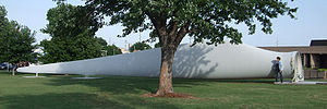
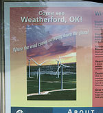
Weatherford is home to the second-largest (as of 2008) wind farm
in Oklahoma, the Weatherford Wind Energy Center, with 98 GE 1.5 MW Wind Turbines, for a total nameplate capacity
of 147 MW.
Interstate 40
was completed east and west of the city in 1960 generally paralleling the old U.S. 66 alignment, which was retained as frontage road. The I-40 bypass skirting Weatherford to the south was completed in July, 1970 the same day the I-40 bypass was opened to traffic 15 miles (24.1 km) to the west at Clinton
and followed shortly thereafter by bypasses at Elk City and Sayre.
In addition to Route 66 and I-40, Weatheford is also served by north-south State Highway 54
.
Custer County, Oklahoma
Custer County is a county located in the U.S. state of Oklahoma. It was named in honor of General George Armstrong Custer. As of 2000, the population was 26,142. Its county seat is Arapaho.-Geography:...
, Oklahoma
Oklahoma
Oklahoma is a state located in the South Central region of the United States of America. With an estimated 3,751,351 residents as of the 2010 census and a land area of 68,667 square miles , Oklahoma is the 28th most populous and 20th-largest state...
, United States
United States
The United States of America is a federal constitutional republic comprising fifty states and a federal district...
. The population was 10,833 at the 2010 census
United States Census, 2010
The Twenty-third United States Census, known as Census 2010 or the 2010 Census, is the current national census of the United States. National Census Day was April 1, 2010 and is the reference date used in enumerating individuals...
.
Geography
Weatherford is located at 35°31′58"N 98°42′2"W (35.532669, -98.700606), elevation 1,647 feet (502 m).According to the United States Census Bureau
United States Census Bureau
The United States Census Bureau is the government agency that is responsible for the United States Census. It also gathers other national demographic and economic data...
, the city has a total area of 5.8 square miles (15 km²).
Demographics
As of the censusCensus
A census is the procedure of systematically acquiring and recording information about the members of a given population. It is a regularly occurring and official count of a particular population. The term is used mostly in connection with national population and housing censuses; other common...
of 2000, there were 9,859 people, 3,991 households, and 2,187 families residing in the city. The population density
Population density
Population density is a measurement of population per unit area or unit volume. It is frequently applied to living organisms, and particularly to humans...
was 1,699.3 people per square mile (656.3/km²). There were 4,468 housing units at an average density of 770.1 per square mile (297.4/km²). The racial makeup of the city was 87.16% White, 1.95% African American, 4.97% Native American, 1.29% Asian, 0.06% Pacific Islander, 1.76% from other races
Race (United States Census)
Race and ethnicity in the United States Census, as defined by the Federal Office of Management and Budget and the United States Census Bureau, are self-identification data items in which residents choose the race or races with which they most closely identify, and indicate whether or not they are...
, and 2.81% from two or more races. Hispanic or Latino of any race were 4.30% of the population.
There were 3,991 households out of which 25.8% had children under the age of 18 living with them, 42.5% were married couples
Marriage
Marriage is a social union or legal contract between people that creates kinship. It is an institution in which interpersonal relationships, usually intimate and sexual, are acknowledged in a variety of ways, depending on the culture or subculture in which it is found...
living together, 9.0% had a female householder with no husband present, and 45.2% were non-families. 31.6% of all households were made up of individuals and 8.3% had someone living alone who was 65 years of age or older. The average household size was 2.27 and the average family size was 2.96.
In the city the population was spread out with 19.8% under the age of 18, 32.1% from 18 to 24, 22.4% from 25 to 44, 16.2% from 45 to 64, and 9.4% who were 65 years of age or older. The median age was 24 years. For every 100 females age 18 and over, there were 91.2 males.
The median income for a household in the city was $26,908, and the median income for a family was $41,401. Males had a median income of $29,683 versus $20,833 for females. The per capita income
Per capita income
Per capita income or income per person is a measure of mean income within an economic aggregate, such as a country or city. It is calculated by taking a measure of all sources of income in the aggregate and dividing it by the total population...
for the city was $16,046. About 11.8% of families and 21.7% of the population were below the poverty line, including 19.1% of those under age 18 and 11.8% of those age 65 or over.
Higher education
Southwestern Oklahoma State UniversitySouthwestern Oklahoma State University
Southwestern Oklahoma State University is a public university in Weatherford and Sayre, Oklahoma. It is one of seven state regional universities in the state of Oklahoma.The current president of SWOSU is Randy Beutler.-History:...
, a public, four-year university is located in Weatherford.
Public education
Weatherford Public SchoolsWeatherford Public Schools
Weatherford Public Schools is a public school district based in Weatherford, Oklahoma, United States.In addition to the city of Weatherford, the district also serves rural areas in southeastern Custer and northeastern Washita counties....
provides public education services to the city of Weatherford as well as surrounding rural areas in southeastern Custer and northeastern Washita
Washita County, Oklahoma
Washita County is a county located in the U.S. state of Oklahoma. As of 2000, the population was 11,508. Its county seat is New Cordell. It was formerly located in Cloud Chief, Oklahoma....
counties. The district operates three elementary schools, one middle school, and one high school.
Private education
Private schools in the area include Western Oklahoma Christian School in nearby ClintonClinton, Oklahoma
Clinton is a city in Custer and Washita counties in the U.S. state of Oklahoma. The population was 9,033 at the 2010 census.-History:The community began in 1899 when two men, J.L. Avant and E.E...
, serving grades pre-kindergarten through six and Corn Bible Academy in the Washita County town of Corn
Corn, Oklahoma
Corn is a town in Washita County, Oklahoma, United States. The population was 503 at the 2010 census.-Geography:Corn is located 13 miles northeast of Cordell in western Oklahoma. Its geographic coordinates are...
that serves students in grades seven through twelve.
Career and Technology Education
Western Technology CenterWestern Technology Center
Western Technology Center is a public career and technology education center founded in 1970 with its main campus located in Burns Flat, Oklahoma. Branch campuses are located in Hobart, Sayre and Weatherford...
provides the opportunity for adults and high school students to get occupationally-specific training. Weatherford Public Schools is a member of the WTC district. As a member of the WTC district, high school juniors and seniors living in the Weatherford School District have the opportunity to attend classes at the WTC campus in Burns Flat. High school students who are residents of the WTC District can enroll in WTC full-time training on a tuition-free basis. Adult students are allowed to attend classes on a tuition basis. Tuition for adult students is $2.00 per training hour. Adult students can apply for financial assistance to attend WTC.
Information and facts
In addition, Weatherford is the hometown of astronaut Thomas P. Stafford, veteran of four space flights and commander of the Gemini 9, Apollo 10
Apollo 10
Apollo 10 was the fourth manned mission in the American Apollo space program. It was an F type mission—its purpose was to be a "dry run" for the Apollo 11 mission, testing all of the procedures and components of a Moon landing without actually landing on the Moon itself. The mission included the...
missions and the Apollo-Soyuz project. The 40000 square feet (3,716.1 m²) Stafford Air & Space Museum
Stafford Air & Space Museum
The Stafford Air & Space Museum is located in Weatherford, Oklahoma, USA. The museum features exhibits about aviation, space exploration and rocketry, and a collection of over 20 historic aircraft...
is home to spacecraft, an actual Titan II
Titan II
The Titan II was an intercontinental ballistic missile and space launcher developed by the Glenn L. Martin Company from the earlier Titan I missile. Titan II was originally used as an ICBM...
missile, WWII V-2 rocket
V-2 rocket
The V-2 rocket , technical name Aggregat-4 , was a ballistic missile that was developed at the beginning of the Second World War in Germany, specifically targeted at London and later Antwerp. The liquid-propellant rocket was the world's first long-range combat-ballistic missile and first known...
, MiG 21, Saturn V
Saturn V
The Saturn V was an American human-rated expendable rocket used by NASA's Apollo and Skylab programs from 1967 until 1973. A multistage liquid-fueled launch vehicle, NASA launched 13 Saturn Vs from the Kennedy Space Center, Florida with no loss of crew or payload...
F-1 engine as well as flown space suits, flight equipment, space shuttle
Space Shuttle
The Space Shuttle was a manned orbital rocket and spacecraft system operated by NASA on 135 missions from 1981 to 2011. The system combined rocket launch, orbital spacecraft, and re-entry spaceplane with modular add-ons...
engines, and a moon rock
Moon rock
Moon rock describes rock that formed on the Earth's moon. The term is also loosely applied to other lunar materials collected during the course of human exploration of the Moon.The rocks collected from the Moon are measured by radiometric dating techniques...
; The museum is located at the Thomas P. Stafford Airport
Thomas P. Stafford Airport
Thomas P. Stafford Airport is a city-owned public-use airport located two miles northeast of the central business district of Weatherford, a city in Custer County, Oklahoma, United States.- Facilities and aircraft :...
.
Weatherford is home to the second-largest (as of 2008) wind farm
Wind farm
A wind farm is a group of wind turbines in the same location used to produce electric power. A large wind farm may consist of several hundred individual wind turbines, and cover an extended area of hundreds of square miles, but the land between the turbines may be used for agricultural or other...
in Oklahoma, the Weatherford Wind Energy Center, with 98 GE 1.5 MW Wind Turbines, for a total nameplate capacity
Nameplate capacity
Nameplate capacity, also known as the rated capacity, nominal capacity, installed capacity or maximum effect, refers to the intended technical full–load sustained output of a facility such as a power plant, a chemical plant, fuel plant, metal refinery, mine, and many others.For dispatchable power,...
of 147 MW.
Transportation
Weatherford was for many years on a main line of the now defunct Rock Island Railroad, which is still in operation by a different owner. With the advent of the automobile, the city was initially located on State Highway 3 starting in the early 1920s, which was redesignated as U.S. Route 66 in 1926 and paved entirely across Western Oklahoma by 1932. Route 66, which followed Main Street through the city, was lined with various tourist businesses including cafes, motels and gasoline stations like most other cities along the highway. Several blocks of Main Street were also paved in brick until the mid 1950s when it was widened to a four-lane thoroughfare.Interstate 40
Interstate 40
Interstate 40 is the third-longest major east–west Interstate Highway in the United States, after I-90 and I-80. Its western end is at Interstate 15 in Barstow, California; its eastern end is at a concurrency of U.S. Route 117 and North Carolina Highway 132 in Wilmington, North Carolina...
was completed east and west of the city in 1960 generally paralleling the old U.S. 66 alignment, which was retained as frontage road. The I-40 bypass skirting Weatherford to the south was completed in July, 1970 the same day the I-40 bypass was opened to traffic 15 miles (24.1 km) to the west at Clinton
Clinton, Oklahoma
Clinton is a city in Custer and Washita counties in the U.S. state of Oklahoma. The population was 9,033 at the 2010 census.-History:The community began in 1899 when two men, J.L. Avant and E.E...
and followed shortly thereafter by bypasses at Elk City and Sayre.
In addition to Route 66 and I-40, Weatheford is also served by north-south State Highway 54
Oklahoma State Highway 54
State Highway 54 is a state highway in western Oklahoma. Running north–south, it exists in two parts, which lie at approximately the same longitude. The southern section's length is ,, while the northern section runs for , for a combined length of...
.
Notable natives
- Thomas P. StaffordThomas Patten StaffordThomas Patten Stafford is a retired American Air Force lieutenant general and former NASA astronaut. He flew aboard two Gemini space flights; and in 1969 was the commander of Apollo 10, the second manned mission to orbit the Moon and the first to fly a lunar module there.In 1975, Stafford was...
- Astronaut - Braden LooperBraden LooperBraden LaVerne Looper is a former Major League Baseball pitcher.-High school:Looper was a scholar athlete while a student at Mangum High School in Mangum, Oklahoma...
- Major League Baseball pitcher - Wes Sims - Professional Football Player
- Paul D. Eaton - U.S. Army Major General (retired), former commanding general in Iraq
- Russell Dennison - Linebacker, University of Oklahoma 2001-2006
- Jesse Colin Flett - Helicopter Flight Mechanic (Active Duty) United States Coast Guard
National Register of Historic Places
- Little Deer Archaeological Site
- Old Science Building
- Owl Blacksmith Shop
- Weatherford Armory