
Waterton Lake
Encyclopedia
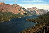
Waterton Lake is a mountain lake
in southern Alberta
, Canada
and northern Montana
, USA. The lake is composed of two bodies of water, connected by a shallow channel known locally as the Bosphorus. The two parts are referred to as Lower Wateron Lake, and Upper Waterton Lake, the latter of which is crossed at the tip by the Canada-United States border
. The United States Geological Survey
gives the geocoordinates of 49°03′00"N 113°54′03"W for Upper Waterton Lake.
The northern, lower end of the main lake lies in Waterton Lakes National Park
while the upper, southern part of the lake is located in Glacier National Park. In 1979, UNESCO
established the Waterton Biosphere Reserve to protect the diverse habitats including prairie grassland
s, aspen parkland
, subalpine forests, alpine tundra
and freshwater fen
s that surround the lake.
Waterton-Glacier International Peace Park
was created by the US and Canada in 1932, and in 1976 it was designated an International Biosphere Reserve. Later, in 1995, it was inscribed as a World Heritage Site
by UNESCO.
The upper and middle Waterton Lake system has a surface of 10.1 km² (3.9 sq mi), while the lower lake, which is in Canada only, has 1.5 km² (0.579153237888803 sq mi) and lies at an altitude of 1274 m (4,179.8 ft). Two soundings of the lake were 210 feet (64 m) and 317 feet (96.6 m), done in 1910. More recent soundings have revealed a depth of 487 ft (149 m).
Highway 5 has its westernmost point on the shores of the lake.
. It continues north and discharges into the Belly River
, a tributary of the Oldman River
.
The total length of the river is 80 km (49.7 mi).
Lake
A lake is a body of relatively still fresh or salt water of considerable size, localized in a basin, that is surrounded by land. Lakes are inland and not part of the ocean and therefore are distinct from lagoons, and are larger and deeper than ponds. Lakes can be contrasted with rivers or streams,...
in southern Alberta
Alberta
Alberta is a province of Canada. It had an estimated population of 3.7 million in 2010 making it the most populous of Canada's three prairie provinces...
, Canada
Canada
Canada is a North American country consisting of ten provinces and three territories. Located in the northern part of the continent, it extends from the Atlantic Ocean in the east to the Pacific Ocean in the west, and northward into the Arctic Ocean...
and northern Montana
Montana
Montana is a state in the Western United States. The western third of Montana contains numerous mountain ranges. Smaller, "island ranges" are found in the central third of the state, for a total of 77 named ranges of the Rocky Mountains. This geographical fact is reflected in the state's name,...
, USA. The lake is composed of two bodies of water, connected by a shallow channel known locally as the Bosphorus. The two parts are referred to as Lower Wateron Lake, and Upper Waterton Lake, the latter of which is crossed at the tip by the Canada-United States border
Canada-United States border
The Canada–United States border, officially known as the International Boundary, is the longest border in the world. The terrestrial boundary is 8,891 kilometers long, including 2,475 kilometres shared with Alaska...
. The United States Geological Survey
United States Geological Survey
The United States Geological Survey is a scientific agency of the United States government. The scientists of the USGS study the landscape of the United States, its natural resources, and the natural hazards that threaten it. The organization has four major science disciplines, concerning biology,...
gives the geocoordinates of 49°03′00"N 113°54′03"W for Upper Waterton Lake.
The northern, lower end of the main lake lies in Waterton Lakes National Park
Waterton Lakes National Park
Waterton Lakes National Park is a national park located in the southwest corner of Alberta, Canada, and borders Glacier National Park in Montana, USA. Waterton was Canada's fourth national park, formed in 1895 and named after Waterton Lake, in turn after the Victorian naturalist and conservationist...
while the upper, southern part of the lake is located in Glacier National Park. In 1979, UNESCO
UNESCO
The United Nations Educational, Scientific and Cultural Organization is a specialized agency of the United Nations...
established the Waterton Biosphere Reserve to protect the diverse habitats including prairie grassland
Grassland
Grasslands are areas where the vegetation is dominated by grasses and other herbaceous plants . However, sedge and rush families can also be found. Grasslands occur naturally on all continents except Antarctica...
s, aspen parkland
Aspen parkland
Aspen parkland refers to a very large area of transitional biome between prairie and boreal forest in two sections; the Peace River Country of northwestern Alberta crossing the border into British Columbia, and a much larger area stretching from central Alberta, all across central Saskatchewan to...
, subalpine forests, alpine tundra
Alpine tundra
Alpine tundra is a natural region that does not contain trees because it is at high altitude. Alpine tundra is distinguished from arctic tundra, because alpine soils are generally better drained than arctic soils...
and freshwater fen
Fen
A fen is a type of wetland fed by mineral-rich surface water or groundwater. Fens are characterised by their water chemistry, which is neutral or alkaline, with relatively high dissolved mineral levels but few other plant nutrients...
s that surround the lake.
Waterton-Glacier International Peace Park
Waterton-Glacier International Peace Park
The Waterton-Glacier International Peace Park is the name of the union of the Waterton Lakes National Park in Canada and the Glacier National Park in the United States...
was created by the US and Canada in 1932, and in 1976 it was designated an International Biosphere Reserve. Later, in 1995, it was inscribed as a World Heritage Site
World Heritage Site
A UNESCO World Heritage Site is a place that is listed by the UNESCO as of special cultural or physical significance...
by UNESCO.
The upper and middle Waterton Lake system has a surface of 10.1 km² (3.9 sq mi), while the lower lake, which is in Canada only, has 1.5 km² (0.579153237888803 sq mi) and lies at an altitude of 1274 m (4,179.8 ft). Two soundings of the lake were 210 feet (64 m) and 317 feet (96.6 m), done in 1910. More recent soundings have revealed a depth of 487 ft (149 m).
Highway 5 has its westernmost point on the shores of the lake.
Waterton River
The Waterton River flows north from the lower lake through the Waterton Reservoir by the village of Hill SpringHill Spring, Alberta
Hill Spring is a village in southern Alberta, Canada. It is located 32 km west of Cardston and 43 km south-east of Pincher Creek, in the Canadian Rockies foothills. It has often been misspelled Hillspring, including the Canada 2006 Census....
. It continues north and discharges into the Belly River
Belly River
Belly River is a river in northwest Montana, United States and southern Alberta, Canada. It is a tributary of the Oldman River, itself a tributary of the South Saskatchewan River....
, a tributary of the Oldman River
Oldman River
The Oldman River is a river in southern Alberta, Canada. It flows roughly west to east from the Rocky Mountains, through the communities of Fort Macleod, Lethbridge, Taber, and on to Grassy Lake, where it joins with the Bow River to form the South Saskatchewan River, which eventually drains into...
.
The total length of the river is 80 km (49.7 mi).