
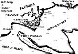
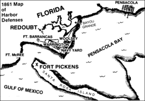
Warrington, Florida
Encyclopedia
Warrington is a census-designated place
(CDP) in Escambia County
, Florida
, United States
, and was once the westernmost incorporated town in Florida. Warrington is located between downtown Pensacola, Florida
, and the state line with Alabama; it is six miles (10 km) away from both.
The population was 15,207 at the 2000 census. It is part of the Pensacola–Ferry Pass
–Brent
Metropolitan Statistical Area
.
Formerly designated as a town, a change in state incorporation standards in 1975 caused Warrington to lose town status. A referendum was held that year to regain the status, which failed. Since then attempts at regaining town status have not presented themselves. Despite falling outside of city limits, and having a post office explicitly named "Warrington," mail going to the addresses in the Warrington ZIP code
(32507) fall under the jurisdiction of Pensacola.
Naval Air Station Pensacola
is located in Warrington (albeit with their own ZIP code, 32508, which corresponds to the mailing city "Naval Air Station Pensacola, FL").
According to the United States Census Bureau
, the CDP has a total area of 8.5 square miles (22 km²), of which, 6.6 square miles (17.1 km²) of it is land and 1.9 square miles (4.9 km²) of it (22.80%) is water.
of 2000, there were 15,207 people, 6,547 households, and 4,046 families residing in the CDP. The population density
was 2,314.1 people per square mile (893.7/km²). There were 7,582 housing units at an average density of 1,153.8/sq mi (445.6/km²). The racial makeup of the CDP was 71.57% White, 21.69% African American, 1.05% Native American, 2.08% Asian, 0.16% Pacific Islander, 0.91% from other races
, and 2.54% from two or more races. Hispanic or Latino of any race were 2.88% of the population.
There were 6,547 households out of which 28.4% had children under the age of 18 living with them, 38.7% were married couples
living together, 18.5% had a female householder with no husband present, and 38.2% were non-families. 31.3% of all households were made up of individuals and 12.0% had someone living alone who was 65 years of age or older. The average household size was 2.32 and the average family size was 2.89.
In the CDP the population was spread out with 25.7% under the age of 18, 9.4% from 18 to 24, 27.7% from 25 to 44, 21.8% from 45 to 64, and 15.4% who were 65 years of age or older. The median age was 36 years. For every 100 females there were 92.3 males. For every 100 females age 18 and over, there were 87.2 males.
 The median income for a household in the CDP was $30,459, and the median income for a family was $35,892. Males had a median income of $29,083 versus $19,375 for females. The per capita income
for the CDP was $17,876. About 17.5% of families and 20.6% of the population were below the poverty line, including 33.8% of those under age 18 and 6.0% of those age 65 or over.
Census-designated place
A census-designated place is a concentration of population identified by the United States Census Bureau for statistical purposes. CDPs are delineated for each decennial census as the statistical counterparts of incorporated places such as cities, towns and villages...
(CDP) in Escambia County
Escambia County, Florida
Escambia County is the westernmost county in the U.S. state of Florida. The 2010 population was 297,619. The U.S. Census Bureau 2005 estimate for the county is 296,772. Its county seat is Pensacola.- History :...
, Florida
Florida
Florida is a state in the southeastern United States, located on the nation's Atlantic and Gulf coasts. It is bordered to the west by the Gulf of Mexico, to the north by Alabama and Georgia and to the east by the Atlantic Ocean. With a population of 18,801,310 as measured by the 2010 census, it...
, United States
United States
The United States of America is a federal constitutional republic comprising fifty states and a federal district...
, and was once the westernmost incorporated town in Florida. Warrington is located between downtown Pensacola, Florida
Pensacola, Florida
Pensacola is the westernmost city in the Florida Panhandle and the county seat of Escambia County, Florida, United States of America. As of the 2000 census, the city had a total population of 56,255 and as of 2009, the estimated population was 53,752...
, and the state line with Alabama; it is six miles (10 km) away from both.
The population was 15,207 at the 2000 census. It is part of the Pensacola–Ferry Pass
Ferry Pass, Florida
Ferry Pass is a census-designated place in Escambia County, Florida, United States. The population was 27,176 at the 2000 census. It is a principal city of the Pensacola-Ferry Pass-Brent Metropolitan Statistical Area.-Geography:...
–Brent
Brent, Florida
Brent is a census-designated place in Escambia County, Florida, United States. The population was 22,257 at the 2000 census. It is a principal city of the Pensacola-Ferry Pass-Brent Metropolitan Statistical Area.-Geography:...
Metropolitan Statistical Area
Pensacola-Ferry Pass-Brent, Florida Metropolitan Statistical Area
30° 26′ 0″ N, 87° 12′ 0″ WThe Pensacola metropolitan area is the metropolitan area centered on Pensacola, Florida.The Office of Management and Budget has designated Escambia and Santa Rosa counties as the Pensacola-Ferry Pass-Brent Metropolitan Statistical Area, a metropolitan statistical area used...
.
Formerly designated as a town, a change in state incorporation standards in 1975 caused Warrington to lose town status. A referendum was held that year to regain the status, which failed. Since then attempts at regaining town status have not presented themselves. Despite falling outside of city limits, and having a post office explicitly named "Warrington," mail going to the addresses in the Warrington ZIP code
ZIP Code
ZIP codes are a system of postal codes used by the United States Postal Service since 1963. The term ZIP, an acronym for Zone Improvement Plan, is properly written in capital letters and was chosen to suggest that the mail travels more efficiently, and therefore more quickly, when senders use the...
(32507) fall under the jurisdiction of Pensacola.
Naval Air Station Pensacola
Naval Air Station Pensacola
Naval Air Station Pensacola or NAS Pensacola , "The Cradle of Naval Aviation", is a United States Navy base located next to Warrington, Florida, a community southwest of the Pensacola city limits...
is located in Warrington (albeit with their own ZIP code, 32508, which corresponds to the mailing city "Naval Air Station Pensacola, FL").
Geography
Warrington is located at 30°23′9"N 87°17′23"W (30.385698, -87.289594).According to the United States Census Bureau
United States Census Bureau
The United States Census Bureau is the government agency that is responsible for the United States Census. It also gathers other national demographic and economic data...
, the CDP has a total area of 8.5 square miles (22 km²), of which, 6.6 square miles (17.1 km²) of it is land and 1.9 square miles (4.9 km²) of it (22.80%) is water.
Demographics
As of the censusCensus
A census is the procedure of systematically acquiring and recording information about the members of a given population. It is a regularly occurring and official count of a particular population. The term is used mostly in connection with national population and housing censuses; other common...
of 2000, there were 15,207 people, 6,547 households, and 4,046 families residing in the CDP. The population density
Population density
Population density is a measurement of population per unit area or unit volume. It is frequently applied to living organisms, and particularly to humans...
was 2,314.1 people per square mile (893.7/km²). There were 7,582 housing units at an average density of 1,153.8/sq mi (445.6/km²). The racial makeup of the CDP was 71.57% White, 21.69% African American, 1.05% Native American, 2.08% Asian, 0.16% Pacific Islander, 0.91% from other races
Race (United States Census)
Race and ethnicity in the United States Census, as defined by the Federal Office of Management and Budget and the United States Census Bureau, are self-identification data items in which residents choose the race or races with which they most closely identify, and indicate whether or not they are...
, and 2.54% from two or more races. Hispanic or Latino of any race were 2.88% of the population.
There were 6,547 households out of which 28.4% had children under the age of 18 living with them, 38.7% were married couples
Marriage
Marriage is a social union or legal contract between people that creates kinship. It is an institution in which interpersonal relationships, usually intimate and sexual, are acknowledged in a variety of ways, depending on the culture or subculture in which it is found...
living together, 18.5% had a female householder with no husband present, and 38.2% were non-families. 31.3% of all households were made up of individuals and 12.0% had someone living alone who was 65 years of age or older. The average household size was 2.32 and the average family size was 2.89.
In the CDP the population was spread out with 25.7% under the age of 18, 9.4% from 18 to 24, 27.7% from 25 to 44, 21.8% from 45 to 64, and 15.4% who were 65 years of age or older. The median age was 36 years. For every 100 females there were 92.3 males. For every 100 females age 18 and over, there were 87.2 males.
Per capita income
Per capita income or income per person is a measure of mean income within an economic aggregate, such as a country or city. It is calculated by taking a measure of all sources of income in the aggregate and dividing it by the total population...
for the CDP was $17,876. About 17.5% of families and 20.6% of the population were below the poverty line, including 33.8% of those under age 18 and 6.0% of those age 65 or over.