
Walcha Council
Encyclopedia
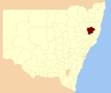
Walcha Shire is a Local Government Area (LGA) in the New England
region of New South Wales
, Australia
. It is at the junction of the Oxley Highway
and Thunderbolts Way
and is 20 kilometres east of the Main North railway line
passing through Walcha Road.
The Shire of Apsley was constituted by proclamation on 7 March 1906. It is in the counties of Vernon
, Hawes
, and Inglis
and comprises about 60 parishes. The area is 1605590 acres (6,497.6 km²). The Shire of Walcha was constituted by the Union of the Municipality and the Shire of Apsley on 1 June 1955.
- were 927 wage and salary earners (ranked 146th in New South Wales and 470th in Australia, less than 0.1% of both New South Wales's 2,558,415 and Australia's 7,831,856)
- was a total income of $27,787,248 (around $28 million) (ranked 147th in New South Wales and 478th in Australia, less than 0.1% of both New South Wales's $107,179,688,262 (around $107 billion) and Australia's $304,034,755,876 (around $304 billion))
- was an estimated average
income per wage and salary earner of $29,975 (ranked 153rd in New South Wales and 517th in Australia, 72% of New South Wales's $41,407 and 77% of Australia's $38,820)
- was an estimated median
income per wage and salary earner of $27,590 (ranked 154th in New South Wales and 517th in Australia, 78% of New South Wales's $35,479 and 81% of Australia's $34,149).
,
Walcha Road
, Niangala
, Nowendoc
and Woolbrook
. Settlements include: Brackendale
, Yarrowitch
and Tia
.
On 28 and 29 November 2008, torrential rain that caused severe flooding in the Apsley River
and Macdonald River
led to the area being declared a natural disaster area. Walcha Council estimated that it will cost approximately $1.7 million to repair damage caused to roads and infrastructure across the shire.
New England (Australia)
New England or New England North West is the name given to a generally undefined region about 60 kilometres inland, that includes the Northern Tablelands and the North West Slopes regions in the north of the state of New South Wales, Australia.-History:The region has been occupied by Indigenous...
region of New South Wales
New South Wales
New South Wales is a state of :Australia, located in the east of the country. It is bordered by Queensland, Victoria and South Australia to the north, south and west respectively. To the east, the state is bordered by the Tasman Sea, which forms part of the Pacific Ocean. New South Wales...
, Australia
Australia
Australia , officially the Commonwealth of Australia, is a country in the Southern Hemisphere comprising the mainland of the Australian continent, the island of Tasmania, and numerous smaller islands in the Indian and Pacific Oceans. It is the world's sixth-largest country by total area...
. It is at the junction of the Oxley Highway
Oxley Highway
The Oxley Highway is a rural highway in New South Wales, Australia. It starts at Nevertire where it joins the Mitchell Highway. It links Warren, Gilgandra, Coonabarabran, Gunnedah, Carroll, Tamworth, Bendemeer, Walcha, Yarrowitch, Ellenborough, Long Flat, Wauchope and ends at Port Macquarie on the...
and Thunderbolts Way
Thunderbolts Way
Thunderbolts Way is a New South Wales country road linking Gloucester to Walcha , Uralla, where it very briefly joins the New England Highway and, to Copes Creek, south of the Gwydir Highway intersection at Inverell...
and is 20 kilometres east of the Main North railway line
Main North railway line, New South Wales
The Main North Line is a major railway in New South Wales, Australia. It runs through the Central Coast, Hunter and the New England regions. The line was the original main line between Sydney and Brisbane, however this required a change of gauge at Wallangarra...
passing through Walcha Road.
The Shire of Apsley was constituted by proclamation on 7 March 1906. It is in the counties of Vernon
Vernon County, New South Wales
Vernon County is one of the 141 Cadastral divisions of New South Wales, Australia. The Macleay River is part of the border in the north-east. It includes Walcha.Vernon County was named in honour of George John Venables-Vernon, 5th Baron Vernon ....
, Hawes
Hawes County, New South Wales
Hawes County is one of the 141 Cadastral divisions of New South Wales. It is bounded on the south by the Manning River.Hawes County was named in honour of Sir Benjamin Hawes .- Parishes within this county:...
, and Inglis
Inglis County, New South Wales
Inglis County is one of the 141 Cadastral divisions of New South Wales. It contains Tamworth and Bendemeer.Inglis County was named in honour of Major-General, Sir John Eardley Wilmot Inglis .- Parishes within this county:...
and comprises about 60 parishes. The area is 1605590 acres (6,497.6 km²). The Shire of Walcha was constituted by the Union of the Municipality and the Shire of Apsley on 1 June 1955.
Incomes
According to the Australian Bureau Statistics during 2003-04, there:- were 927 wage and salary earners (ranked 146th in New South Wales and 470th in Australia, less than 0.1% of both New South Wales's 2,558,415 and Australia's 7,831,856)
- was a total income of $27,787,248 (around $28 million) (ranked 147th in New South Wales and 478th in Australia, less than 0.1% of both New South Wales's $107,179,688,262 (around $107 billion) and Australia's $304,034,755,876 (around $304 billion))
- was an estimated average
Average
In mathematics, an average, or central tendency of a data set is a measure of the "middle" value of the data set. Average is one form of central tendency. Not all central tendencies should be considered definitions of average....
income per wage and salary earner of $29,975 (ranked 153rd in New South Wales and 517th in Australia, 72% of New South Wales's $41,407 and 77% of Australia's $38,820)
- was an estimated median
Median
In probability theory and statistics, a median is described as the numerical value separating the higher half of a sample, a population, or a probability distribution, from the lower half. The median of a finite list of numbers can be found by arranging all the observations from lowest value to...
income per wage and salary earner of $27,590 (ranked 154th in New South Wales and 517th in Australia, 78% of New South Wales's $35,479 and 81% of Australia's $34,149).
Main towns and villages
The towns and villages of Walcha Council include WalchaWalcha, New South Wales
Walcha is a parish and town at the south-eastern edge of the Northern Tablelands, New South Wales, Australia.The town serves as the seat of Walcha Shire. Walcha is located 425 kilometres by road from Sydney at the intersection of the Oxley Highway and Thunderbolts Way...
,
Walcha Road
Walcha Road, New South Wales
Walcha Road is a rural village with a population of about 20, located west of Walcha in the Northern Tablelands of New South Wales, Australia.The railway line through here from Sydney to Uralla was completed in 1882...
, Niangala
Niangala, New South Wales
Niangala is a village located on the south-eastern edge of the Northern Tablelands area of New South Wales, Australia. It is on the Moonbi Range which is part of the Great Dividing Range, at approximately above sea level. The village is in Walcha parish in Parry County...
, Nowendoc
Nowendoc, New South Wales
Nowendoc is a parish and village on the Northern Tablelands, New South Wales, Australia. The town is located 360 km north of the state capital, Sydney, 66 km south of Walcha and is in the Walcha Shire Local Government Area...
and Woolbrook
Woolbrook, New South Wales
Woolbrook is a village in the New England region of New South Wales, Australia. The nearest town, Walcha is 29 km to the east of Woolbrook. At the 2006 census, Woolbrook had a population of 220....
. Settlements include: Brackendale
Brackendale, New South Wales
Brackendale is a rural locality situated on the Riamukka Road about 29 kilometres south of Walcha, New South Wales and is included in the Walcha Shire Local Government Area on the Northern Tablelands in Australia....
, Yarrowitch
Yarrowitch, New South Wales
Yarrowitch is a parish and a small rural locality on the Northern Tablelands, New South Wales, Australia. It is located in the picturesque Yarrowitch River Valley on the Oxley Highway 48 kilometres east of Walcha. The settlement is included in the Walcha Shire Local Government Area in the New...
and Tia
Tia, New South Wales
Tia, is a settlement and parish located approximately 30 kilometres east of Walcha, on the Northern Tablelands region of New South Wales, Australia....
.
On 28 and 29 November 2008, torrential rain that caused severe flooding in the Apsley River
Apsley River (New South Wales)
The Apsley River is a river on the Northern Tablelands of New South Wales, Australia. The headwaters of the river rise in high country about 11 kilometres west of Tia and approximately 29 km south of Walcha, New South Wales.- Geography :...
and Macdonald River
Macdonald River (Bendemeer)
There are two rivers named Macdonald River in New South Wales, Australia. See Macdonald RiverThe Macdonald River in northern New South Wales is the headwater of the Namoi River. It rises east of Niangala on the western slopes of the Great Dividing Range on the Northern Tablelands, New South Wales...
led to the area being declared a natural disaster area. Walcha Council estimated that it will cost approximately $1.7 million to repair damage caused to roads and infrastructure across the shire.