
Waimanalo Beach, Hawaii
Encyclopedia
Waimānalo Beach is a census-designated place
(CDP) located in the City & County of Honolulu
, in the District of Koolaupoko on the island of Oahu
in the U.S. state
of Hawaii
. This small windward
community is located near the eastern end of the island and the climate is dry
. As of the 2000 Census
, the town had a total population of 4,271. This neighborhood is close to, but somewhat separate from Waimānalo
, although the two form a single community.
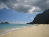
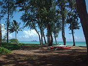
Waimānalo Beach (the town) lies along the eastern half of Waimānalo Beach (the beach), with an overall length of nearly 5.5 mi (8.9 km), the longest stretch of sand
y shoreline on Oahu. Waimānalo Beach has sparse commercial development along Kalanianaole Highway, and is noteworthy for its local flavor and proximity to Makapuu Beach and Sea Life Park, which lie closer to Makapuu Point at the east end of the Island of Oahu. There are no hotels here.
The U.S. postal code
for Waimānalo Beach and Waimānalo is 96795.
Kazuo Sakamaki
, the first prisoner of war
taken by U.S. forces during World War II
, was captured on 7 December 1941
on Waimānalo Beach.
The Anderson Estate, which was featured in the TV series Magnum, P.I.
as "Robin's Nest", is located in Waimānalo Beach.
to the west.
According to the United States Census Bureau
, the town has a total area of 3 square miles (7.8 km²), of which, 1.6 square miles (4.1 km²) of it is land and 1.4 square miles (3.6 km²) of it is water. The total area is 46.56% water.
of 2000, there were 4,271 people, 1,006 households, and 848 families residing in the CDP. The population density
was 2,617.1 people per square mile (1,011.7/km²). There were 1,046 housing units at an average density of 640.9 per square mile (247.8/km²). The racial makeup of the CDP was 12.97% White, 0.09% African American
, 0.23% Native American, 5.34% Asian, 47.39% Pacific Islander, 0.63% from other races, and 33.34% from two or more races. 6.49% of the population were Hispanic or Latino
of any race.
There were 1,006 households out of which 28.7% had children under the age of 18 living with them, 51.4% were married couples
living together, 23.2% had a female householder with no husband present, and 15.7% were non-families. 8.9% of all households were made up of individuals and 2.7% had someone living alone who was 65 years of age or older. The average household size was 4.25 and the average family size is 4.50.
In the CDP the population was spread out with 26.7% under the age of 18, 10.3% from 18 to 24, 28.9% from 25 to 44, 22.5% from 45 to 64, and 11.6% who were 65 years of age or older. The median age was 35 years. For every 100 females there were 97.5 males. For every 100 females age 18 and over, there were 92.7 males.
The median income for a household in the CDP was $55,781, and the median income for a family was $57,281. Males had a median income of $35,074 versus $25,440 for females. The per capita income
for the town was $16,089. 8.5% of the population and 5.5% of families were below the poverty line. Out of the total population, 5.3% of those under the age of 18 and 7.9% of those 65 and older were living below the poverty line.
Census-designated place
A census-designated place is a concentration of population identified by the United States Census Bureau for statistical purposes. CDPs are delineated for each decennial census as the statistical counterparts of incorporated places such as cities, towns and villages...
(CDP) located in the City & County of Honolulu
Honolulu County, Hawaii
The City and County of Honolulu is a consolidated city–county located in the U.S. state of Hawaii. The municipality and county includes both the urban district of Honolulu and the rest of the island of Oahu, as well as several minor outlying islands, including all of the Northwestern Hawaiian...
, in the District of Koolaupoko on the island of Oahu
Oahu
Oahu or Oahu , known as "The Gathering Place", is the third largest of the Hawaiian Islands and most populous of the islands in the U.S. state of Hawaii. The state capital Honolulu is located on the southeast coast...
in the U.S. state
U.S. state
A U.S. state is any one of the 50 federated states of the United States of America that share sovereignty with the federal government. Because of this shared sovereignty, an American is a citizen both of the federal entity and of his or her state of domicile. Four states use the official title of...
of Hawaii
Hawaii
Hawaii is the newest of the 50 U.S. states , and is the only U.S. state made up entirely of islands. It is the northernmost island group in Polynesia, occupying most of an archipelago in the central Pacific Ocean, southwest of the continental United States, southeast of Japan, and northeast of...
. This small windward
Windward and leeward
Windward is the direction upwind from the point of reference. Leeward is the direction downwind from the point of reference. The side of a ship that is towards the leeward is its lee side. If the vessel is heeling under the pressure of the wind, this will be the "lower side"...
community is located near the eastern end of the island and the climate is dry
Hawaiian tropical dry forests
The Hawaiian tropical dry forests are a tropical dry broadleaf forest ecoregion in the Hawaiian Islands. They cover an area of on the leeward side of the main islands and the summits of Niihau and Kahoolawe. These forests are either seasonal or sclerophyllous. Annual rainfall is less than and...
. As of the 2000 Census
United States Census, 2000
The Twenty-second United States Census, known as Census 2000 and conducted by the Census Bureau, determined the resident population of the United States on April 1, 2000, to be 281,421,906, an increase of 13.2% over the 248,709,873 persons enumerated during the 1990 Census...
, the town had a total population of 4,271. This neighborhood is close to, but somewhat separate from Waimānalo
Waimanalo, Hawai'i
Waimānalo is a census-designated place in the City & County of Honolulu, in the District of Koolaupoko on the island of Oahu. This small windward community is located near the eastern end of the island. In the Hawaiian language Waimānalo means "potable water"; it is so named for the many brackish...
, although the two form a single community.
Waimānalo Beach (the town) lies along the eastern half of Waimānalo Beach (the beach), with an overall length of nearly 5.5 mi (8.9 km), the longest stretch of sand
Sand
Sand is a naturally occurring granular material composed of finely divided rock and mineral particles.The composition of sand is highly variable, depending on the local rock sources and conditions, but the most common constituent of sand in inland continental settings and non-tropical coastal...
y shoreline on Oahu. Waimānalo Beach has sparse commercial development along Kalanianaole Highway, and is noteworthy for its local flavor and proximity to Makapuu Beach and Sea Life Park, which lie closer to Makapuu Point at the east end of the Island of Oahu. There are no hotels here.
The U.S. postal code
Postal code
A postal code is a series of letters and/or digits appended to a postal address for the purpose of sorting mail. Once postal codes were introduced, other applications became possible.In February 2005, 117 of the 190 member countries of the Universal Postal Union had postal code systems...
for Waimānalo Beach and Waimānalo is 96795.
Kazuo Sakamaki
Kazuo Sakamaki
was a Japanese naval officer who became the first Japanese prisoner of war of World War II captured by American forces.-Biography:Sakamaki was born in what is now part of the city of Awa, Tokushima Prefecture...
, the first prisoner of war
Prisoner of war
A prisoner of war or enemy prisoner of war is a person, whether civilian or combatant, who is held in custody by an enemy power during or immediately after an armed conflict...
taken by U.S. forces during World War II
World War II
World War II, or the Second World War , was a global conflict lasting from 1939 to 1945, involving most of the world's nations—including all of the great powers—eventually forming two opposing military alliances: the Allies and the Axis...
, was captured on 7 December 1941
Attack on Pearl Harbor
The attack on Pearl Harbor was a surprise military strike conducted by the Imperial Japanese Navy against the United States naval base at Pearl Harbor, Hawaii, on the morning of December 7, 1941...
on Waimānalo Beach.
The Anderson Estate, which was featured in the TV series Magnum, P.I.
Magnum, P.I.
Magnum, P.I. is an American television series starring Tom Selleck as Thomas Magnum, a private investigator living on Oahu, Hawaii. The series ran from 1980 to 1988 in first-run broadcast on the American CBS television network....
as "Robin's Nest", is located in Waimānalo Beach.
Geography
Waimānalo Beach is located at 21°20′1"N 157°41′53"W (21.333657, -157.698055). The nearest town is WaimānaloWaimanalo, Hawai'i
Waimānalo is a census-designated place in the City & County of Honolulu, in the District of Koolaupoko on the island of Oahu. This small windward community is located near the eastern end of the island. In the Hawaiian language Waimānalo means "potable water"; it is so named for the many brackish...
to the west.
According to the United States Census Bureau
United States Census Bureau
The United States Census Bureau is the government agency that is responsible for the United States Census. It also gathers other national demographic and economic data...
, the town has a total area of 3 square miles (7.8 km²), of which, 1.6 square miles (4.1 km²) of it is land and 1.4 square miles (3.6 km²) of it is water. The total area is 46.56% water.
Demographics
As of the censusCensus
A census is the procedure of systematically acquiring and recording information about the members of a given population. It is a regularly occurring and official count of a particular population. The term is used mostly in connection with national population and housing censuses; other common...
of 2000, there were 4,271 people, 1,006 households, and 848 families residing in the CDP. The population density
Population density
Population density is a measurement of population per unit area or unit volume. It is frequently applied to living organisms, and particularly to humans...
was 2,617.1 people per square mile (1,011.7/km²). There were 1,046 housing units at an average density of 640.9 per square mile (247.8/km²). The racial makeup of the CDP was 12.97% White, 0.09% African American
African American
African Americans are citizens or residents of the United States who have at least partial ancestry from any of the native populations of Sub-Saharan Africa and are the direct descendants of enslaved Africans within the boundaries of the present United States...
, 0.23% Native American, 5.34% Asian, 47.39% Pacific Islander, 0.63% from other races, and 33.34% from two or more races. 6.49% of the population were Hispanic or Latino
Latino
The demonyms Latino and Latina , are defined in English language dictionaries as:* "a person of Latin-American descent."* "A Latin American."* "A person of Hispanic, especially Latin-American, descent, often one living in the United States."...
of any race.
There were 1,006 households out of which 28.7% had children under the age of 18 living with them, 51.4% were married couples
Marriage
Marriage is a social union or legal contract between people that creates kinship. It is an institution in which interpersonal relationships, usually intimate and sexual, are acknowledged in a variety of ways, depending on the culture or subculture in which it is found...
living together, 23.2% had a female householder with no husband present, and 15.7% were non-families. 8.9% of all households were made up of individuals and 2.7% had someone living alone who was 65 years of age or older. The average household size was 4.25 and the average family size is 4.50.
In the CDP the population was spread out with 26.7% under the age of 18, 10.3% from 18 to 24, 28.9% from 25 to 44, 22.5% from 45 to 64, and 11.6% who were 65 years of age or older. The median age was 35 years. For every 100 females there were 97.5 males. For every 100 females age 18 and over, there were 92.7 males.
The median income for a household in the CDP was $55,781, and the median income for a family was $57,281. Males had a median income of $35,074 versus $25,440 for females. The per capita income
Per capita income
Per capita income or income per person is a measure of mean income within an economic aggregate, such as a country or city. It is calculated by taking a measure of all sources of income in the aggregate and dividing it by the total population...
for the town was $16,089. 8.5% of the population and 5.5% of families were below the poverty line. Out of the total population, 5.3% of those under the age of 18 and 7.9% of those 65 and older were living below the poverty line.
External links
- Hawai`i Beach Safety Website - Current beach conditions and information from Hawaii Lifeguard Association