

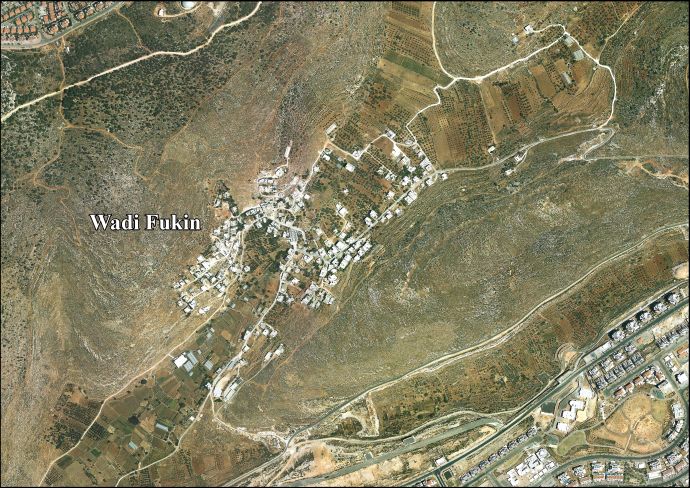
Wadi Fukin
Encyclopedia
Wadi Fukin is a Palestinian
village in the West Bank, eight kilometers southwest of Bethlehem
in the Bethlehem Governorate
. The village is located between the Green Line
and the Israeli West Bank barrier
. According to the Palestinian Central Bureau of Statistics
, Wadi Fukin had a population of over 1,168 in 2007. The town relies on agriculture as its primary source of income.
in 1967, when Jordan lost the West Bank and East Jerusalem
to Israel. In 1972, the inhabitants were permitted to return on condition that they built homes within a month.
s (4,347 dunams), 20.1 hectares of which are built-up. Much of the remaining land is planted with orchards and vineyards. Israel allotted 5.1 hectares to Israeli settlement
s near the town and an additional 88.5 hectares were seized in 2005. The Israeli West Bank barrier
separates 103.9 hectares from the majority of the town's area. As a result of the Interim Agreement on the West Bank and the Gaza Strip
in 1995, 93.6% of Wadi Fukin's land is located in Area C (complete Israeli control) while 6.4% is located in Area B which is under the administration of the Palestinian National Authority
and Israeli security. Wadi Fukin is connected to Bethlehem by the village's main road.
The village is watered by 11 springs used to irrigate hundreds of small farm plots using a system of canals and dams.
organization taught the villagers additional techniques of ecological and organic farming, but the presence of military checkpoints has prevented them from marketing their produce in Israel where prices are higher. Residents of Tzur Hadassah
, an Israeli bedroom community bounding the village to the west, were the first to buy from the villagers, paying a fixed weekly price for fresh seasonal produce. Another project in October 2007 involved direct marketing of the produce to households in Jerusalem.
Palestinian territories
The Palestinian territories comprise the West Bank and the Gaza Strip. Since the Palestinian Declaration of Independence in 1988, the region is today recognized by three-quarters of the world's countries as the State of Palestine or simply Palestine, although this status is not recognized by the...
village in the West Bank, eight kilometers southwest of Bethlehem
Bethlehem
Bethlehem is a Palestinian city in the central West Bank of the Jordan River, near Israel and approximately south of Jerusalem, with a population of about 30,000 people. It is the capital of the Bethlehem Governorate of the Palestinian National Authority and a hub of Palestinian culture and tourism...
in the Bethlehem Governorate
Bethlehem Governorate
The Bethlehem Governorate is one of 16 Governorates of the West Bank and Gaza Strip within the Palestinian Territories. It covers an area of the West Bank, south of Jerusalem. Its principal city and district capital is Bethlehem...
. The village is located between the Green Line
Green Line (Israel)
Green Line refers to the demarcation lines set out in the 1949 Armistice Agreements between Israel and its neighbours after the 1948 Arab-Israeli War...
and the Israeli West Bank barrier
Israeli West Bank barrier
The Israeli West Bank barrier is a separation barrier being constructed by the State of Israel along and within the West Bank. Upon completion, the barrier’s total length will be approximately...
. According to the Palestinian Central Bureau of Statistics
Palestinian Central Bureau of Statistics
The Palestinian Central Bureau of Statistics is the statistical organization under the umbrella of the Palestinian Cabinet of the Palestinian National Authority....
, Wadi Fukin had a population of over 1,168 in 2007. The town relies on agriculture as its primary source of income.
History
In 1948, the village was occupied by the Israel Defense Forces and its Arab residents were expelled. The villagers returned in September 1949, after the Israeli-Jordanian armistice agreement, finding many of their homes destroyed. The United Nations Chairman of the Mixed Commission, Colonel Garrison B. Coverdale, helped to work out an adjustment whereby Wadi Fukin was restored to Jordanian control and certain tracts of fertile land south of Bethlehem were transferred to Israel. The residents fled again after the Six-Day WarSix-Day War
The Six-Day War , also known as the June War, 1967 Arab-Israeli War, or Third Arab-Israeli War, was fought between June 5 and 10, 1967, by Israel and the neighboring states of Egypt , Jordan, and Syria...
in 1967, when Jordan lost the West Bank and East Jerusalem
East Jerusalem
East Jerusalem or Eastern Jerusalem refer to the parts of Jerusalem captured and annexed by Jordan in the 1948 Arab-Israeli War and then captured and annexed by Israel in the 1967 Six-Day War...
to Israel. In 1972, the inhabitants were permitted to return on condition that they built homes within a month.
Geography
Wadi Fukin has a total land area of 434.7 hectareHectare
The hectare is a metric unit of area defined as 10,000 square metres , and primarily used in the measurement of land. In 1795, when the metric system was introduced, the are was defined as being 100 square metres and the hectare was thus 100 ares or 1/100 km2...
s (4,347 dunams), 20.1 hectares of which are built-up. Much of the remaining land is planted with orchards and vineyards. Israel allotted 5.1 hectares to Israeli settlement
Israeli settlement
An Israeli settlement is a Jewish civilian community built on land that was captured by Israel from Jordan, Egypt, and Syria during the 1967 Six-Day War and is considered occupied territory by the international community. Such settlements currently exist in the West Bank...
s near the town and an additional 88.5 hectares were seized in 2005. The Israeli West Bank barrier
Israeli West Bank barrier
The Israeli West Bank barrier is a separation barrier being constructed by the State of Israel along and within the West Bank. Upon completion, the barrier’s total length will be approximately...
separates 103.9 hectares from the majority of the town's area. As a result of the Interim Agreement on the West Bank and the Gaza Strip
Interim Agreement on the West Bank and the Gaza Strip
The Interim Agreement on the West Bank and the Gaza Strip, also known as the Israeli-Palestinian Interim Agreement, the Interim Agreement, Oslo 2, Oslo II, and Taba, was a key and complex agreement governing several aspects of the Palestinian territories of Gaza Strip and the West Bank.-History:It...
in 1995, 93.6% of Wadi Fukin's land is located in Area C (complete Israeli control) while 6.4% is located in Area B which is under the administration of the Palestinian National Authority
Palestinian National Authority
The Palestinian Authority is the administrative organization established to govern parts of the West Bank and Gaza Strip...
and Israeli security. Wadi Fukin is connected to Bethlehem by the village's main road.
The village is watered by 11 springs used to irrigate hundreds of small farm plots using a system of canals and dams.
Infrastructure
There are two elementary schools, a mosque, a pharmacy and health clinic in Wadi Fukin. The area around Wadi Fukin is known for its stone masonry, and a stone-cutting factory is located in the village.Organic farming
Wadi Fukin has long been known for the high quality of its agricultural produce. The Friends of the EarthFriends of the Earth
Friends of the Earth International is an international network of environmental organizations in 76 countries.FOEI is assisted by a small secretariat which provides support for the network and its agreed major campaigns...
organization taught the villagers additional techniques of ecological and organic farming, but the presence of military checkpoints has prevented them from marketing their produce in Israel where prices are higher. Residents of Tzur Hadassah
Tzur Hadassah
Tzur Hadassah is a communal settlement in central Israel. Located in the Judean Hills around west of Jerusalem, it falls under the jurisdiction of Mateh Yehuda Regional Council. In 2008 it had a population of 6,100....
, an Israeli bedroom community bounding the village to the west, were the first to buy from the villagers, paying a fixed weekly price for fresh seasonal produce. Another project in October 2007 involved direct marketing of the produce to households in Jerusalem.