

Vágsfjørður
Encyclopedia
Fjord
Geologically, a fjord is a long, narrow inlet with steep sides or cliffs, created in a valley carved by glacial activity.-Formation:A fjord is formed when a glacier cuts a U-shaped valley by abrasion of the surrounding bedrock. Glacial melting is accompanied by rebound of Earth's crust as the ice...
on the island
Island
An island or isle is any piece of sub-continental land that is surrounded by water. Very small islands such as emergent land features on atolls can be called islets, cays or keys. An island in a river or lake may be called an eyot , or holm...
of Suðuroy
Suðuroy
Suðuroy is the southernmost of the Faroe Islands. The island covers 163.7 km². In 2010 there were 4763 inhabitants, but there has been a gradual decline in the population numbers ever since the 1950s....
in the Faroe Islands
Faroe Islands
The Faroe Islands are an island group situated between the Norwegian Sea and the North Atlantic Ocean, approximately halfway between Scotland and Iceland. The Faroe Islands are a self-governing territory within the Kingdom of Denmark, along with Denmark proper and Greenland...
. The fjord is located in the southern part and on the eastern side of the island. The distance between the east and the west coast of Suðuroy is very short from Vágsfjørður to Vágseiði. Between the fjord and Vágseiði is a lake which is called Vatnið (The Lake). There are five villages around the fjord. In the bottom of the fjord is Vágur, which is one of the largest village in Suðuroy. Further east on the northern side of the fjord is Porkeri, in between Vágur and Porkeri is the small village Nes, where a famous artist Ruth Smith
Ruth Smith (artist)
Ruth Smith Nielsen was a Faroese artist. She lived for some years in Denmark, where she was educated as a painter first on the Bizzie Højer Art School and later on the Art Academy of Copenhagen...
lived, she drowned in Vágsfjørður at the age of 45. On the southern side of Vágsfjørður is Lopransfjørður, but just before the village Lopra is a bay, which is called Ónavík, if one turns right there towards west one comes to Lopranseiði on the west coast. Tourists like to come there to enjoy the rough nature there and the beautiful view towards Beinisvørð
Beinisvørð
Beinisvørð is a 470 meter high sea cliff in Suðuroy, Faroe Islands, the highest sea cliff in Suðuroy. It is located between the villages of Lopra and Sumba. Beinisvørð has vertical cliffs facing the sea and a green slope down towards the village of Sumba...
, a 470 meter high sea cliff. After Ónavík the village Lopra
Lopra
Lopra is a village on the island of Suðuroy with the postal code FO 926. In 2009 its population was 96. It is located in the Municipality of Sumba along with the villages Akrar, Sumba and Víkarbyrgi, constituting the southernmost settlements in the Faroe Islands...
. 2 km further east on Lopransfjørður is a small village which is called Akrar
Akrar
Akrar is a village in the Faroe Islands. It is located on Lopransfjørður, an inlet, which itself is part of Vágsfjørður, on the east-side of Suðuroy, and was founded in the year 1817.-External links:...
.
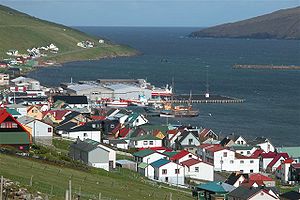
The Harbour of Vágur
Vágs Havn is the harbour of Vágur. The fjord is 10-15 metres deep where the harbour is. The municipality of VágurVágur
Vágur meaning Bay is a town on the Faroe Islands of Suðuroy, it is situated on the east coast of the island on the Vágsfjørður fjord, and dates from the fourteenth century. Expansion has meant that the nearby town of Nes is now a suburb of Vágur...
made it deeper in 2004, it was a big investment. There are fish factories in the harbour. There is also a ferry port, but no ferry arrives there regularly any more. Smyril M/F
Smyril
The Smyril is a passenger / car ferry owned and operated by the Faroese transport company Strandfaraskip Landsins. She is the largest ferry in the fleet and the 5th vessel to carry the name Smyril, which is the Faroese word for Merlin....
used to embark and disembark to and from Vágur a few times weekly, but because the distance between Tórshavn
Tórshavn
Tórshavn is the capital and largest town of the Faroe Islands. It is located in the southern part on the east coast of Streymoy. To the north west of the town lies the high mountain Húsareyn, and to the southwest, the high Kirkjubøreyn...
and Tvøroyri
Tvøroyri
Tvøroyri lies picturesquely on the north side of the Trongisvágsfjørður on the east coast of Suðuroy, Faroe Islands....
is shorter Smyril stopped to sail to Vágur
Vágur
Vágur meaning Bay is a town on the Faroe Islands of Suðuroy, it is situated on the east coast of the island on the Vágsfjørður fjord, and dates from the fourteenth century. Expansion has meant that the nearby town of Nes is now a suburb of Vágur...
, now it sails between Tórshavn
Tórshavn
Tórshavn is the capital and largest town of the Faroe Islands. It is located in the southern part on the east coast of Streymoy. To the north west of the town lies the high mountain Húsareyn, and to the southwest, the high Kirkjubøreyn...
and Krambatangi
Krambatangi
Krambatangi is the ferry port of Suðuroy in the Faroe Islands. The ferry Smyril M/F disembarks 2-3 times daily from Krambatangi to Tórshavn. Krambatangi is located on the southern side of Trongisvágsfjørður halfway between Trongisvágur and Øravík, opposite of Tvøroyri. The ferry port was earlier on...
on Trongisvágsfjørður.