
Virginia State Route 61
Encyclopedia
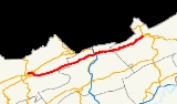
Virginia State Route 61 is a primary state highway
in the U.S. state of Virginia
. The state highway runs 48.16 miles (77.5 km) from SR 16
in Tazewell
east to U.S. Route 460
(US 460) in Narrows
. SR 61 passes through several narrow creek valleys as it parallels the West Virginia
state line through Tazewell
, Bland
, and Giles
counties. The only sizeable community between the highway's endpoints is Rocky Gap
, where the highway meets US 52 and Interstate 77
(I-77).
neighborhood of the town of Tazewell. SR 16 continues west along Riverside Drive and south as Tazewell Avenue, which heads into the downtown area. SR 61 parallels the Clinch River
east through a four-ramp partial cloverleaf interchange with US 19
and US 460 to the neighborhood of Fourway
. There, SR 61 turns south, meets a Norfolk Southern Railway
rail line at grade, and crosses the North Folk Clinch River. Just south of the river, just east of the confluence of the North and South forks to form the main river, the state highway intersects US 19 Business and US 460 Business (Fincastle Turnpike).
SR 61 leaves the town of Tazewell and curves to the east to follow the South Fork Clinch River through the Clinch Valley between Buckhorn Mountain to the north and Rich Mountain to the south. The state highway passes through the hamlet of Burtons Shop on its way to the source of the South Folk just west of the Tennessee Valley Divide
in the community of Gratton
, where the highway intersects SR 623 (Burkes Garden Road), which leads over Rich Mountain to Burkes Garden. SR 61 continues east along Clear Fork through the community of Shawver Mill and enters Bland County. The state highway continues east as Clear Fork Creek Road, which passes through Cove Creek, Stowersville, and Clear Creek on the way to Rocky Gap. SR 61 has a short concurrency
with US 52 (Scenic Highway), during the road briefly expands to a four-lane divided highway through a diamond interchange
with I-77. The two highways make a sharp turn north, then split in the center of the village where Clear Fork enters Wolf Creek.
SR 61 continues east as Wolf Creek Road through the valley of Wolf Creek between Buckhorn Mountain to the north and Wolf Creek Mountain to the south. The highway passes through Round Bottom then enters Giles County. SR 61 passes through the tiny communities of Day, Phlegar, First Ford, Boxley, Chapel, Penvir, and Shumate on their way to Narrows. The state highway enters the town as Park Drive, crosses Wolf Creek, and continues as Monroe Street. North of its intersection with SR 100
(Main Street), SR 61 continues as McArthur Lane, which passes under a Norfolk Southern rail line and crosses over the New River and US 460 (Virginia Avenue). The state highway turns east onto Fleshman Street and turns south to reach its eastern terminus at an intersection with US 460.
!County
!Location
!Mile
!Destinations
!Notes
|-
|rowspan=3|Tazewell
|rowspan=3|Tazewell
|0.00
|
|Western terminus
|-
|0.86
|
|Interchange
|-
|2.15
|
|
|-16.02
|rowspan=3|Bland
|rowspan=3|Rocky Gap
|26.55
|
|West end of concurrency with US 52
|-
|26.61
|
|I-77 Exit 64
|-
|27.01
|
|East end of concurrency with US 52
|-34.43
|rowspan=2|Giles
|rowspan=2|Narrows
|47.60
|
|
|-
|48.16
|
|Eastern terminus
State highway
State highway, state road or state route can refer to one of three related concepts, two of them related to a state or provincial government in a country that is divided into states or provinces :#A...
in the U.S. state of Virginia
Virginia
The Commonwealth of Virginia , is a U.S. state on the Atlantic Coast of the Southern United States. Virginia is nicknamed the "Old Dominion" and sometimes the "Mother of Presidents" after the eight U.S. presidents born there...
. The state highway runs 48.16 miles (77.5 km) from SR 16
Virginia State Route 16
State Route 16 is a primary state highway in the southwest part of the U.S. state of Virginia. It runs from the North Carolina border at North Carolina Highway 16 north to the West Virginia border at West Virginia Route 16, passing through the towns of Troutdale, Marion, and Tazewell.-Grayson...
in Tazewell
Tazewell, Virginia
Tazewell is a town in Tazewell County, Virginia, USA. The population was 4,206 at the 2000 census. It is part of the Bluefield, WV-VA micropolitan area, which has a population of 107,578. It is the county seat of Tazewell County....
east to U.S. Route 460
U.S. Route 460 in Virginia
U.S. Route 460 in Virginia runs east–west through the southern part of the state. It has two separate pieces in Virginia, joined by a relatively short section in West Virginia...
(US 460) in Narrows
Narrows, Virginia
Narrows, named for the narrowing of the New River that flows past it, is a town in Giles County, Virginia, United States. The population was 2,111 at the 2000 census...
. SR 61 passes through several narrow creek valleys as it parallels the West Virginia
West Virginia
West Virginia is a state in the Appalachian and Southeastern regions of the United States, bordered by Virginia to the southeast, Kentucky to the southwest, Ohio to the northwest, Pennsylvania to the northeast and Maryland to the east...
state line through Tazewell
Tazewell County, Virginia
As of the census of 2000, there were 44,598 people, 18,277 households and 13,232 families residing in the county. The population density was 86 people per square mile . There were 20,390 housing units at an average density of 39 per square mile...
, Bland
Bland County, Virginia
As of the census of 2000, there were 6,871 people, 2,568 households, and 1,908 families residing in the county. The population density was 19 people per square mile . There were 3,161 housing units at an average density of 9 per square mile...
, and Giles
Giles County, Virginia
As of the census of 2000, there were 16,657 people, 6,994 households, and 4,888 families residing in the county. The population density was 47 people per square mile . There were 7,732 housing units at an average density of 22 per square mile...
counties. The only sizeable community between the highway's endpoints is Rocky Gap
Rocky Gap, Virginia
Rocky Gap is an unincorporated community that is located in Bland County in the U.S. state of Virginia. Rocky Gap's center sits at a high elevation of around 2,887 ft. In the year of 2009, there was an estimate that there were a total of 75 people living in Rocky Gap. Rocky Gap has one zip code...
, where the highway meets US 52 and Interstate 77
Interstate 77 in Virginia
In the U.S. state of Virginia, Interstate 77 is a north–south along the U.S. Route 52 corridor, serving Hillsville, Wytheville, and Bland...
(I-77).
Route description
SR 61 begins at an intersection with SR 16 in the North TazewellNorth Tazewell, Virginia
North Tazewell is an neighborhood of Tazewell, Virginia, United States. North Tazewell has its own post office with ZIP code 24630....
neighborhood of the town of Tazewell. SR 16 continues west along Riverside Drive and south as Tazewell Avenue, which heads into the downtown area. SR 61 parallels the Clinch River
Clinch River
The Clinch River rises in Southwest Virginia near Tazewell, Virginia and flows southwest through the Great Appalachian Valley, gathering various tributaries including the Powell River before joining the Tennessee River in East Tennessee.-Course:...
east through a four-ramp partial cloverleaf interchange with US 19
U.S. Route 19 in Virginia
U.S. Route 19 is a part of the U.S. Highway System that runs from Memphis, Florida to Erie, Pennsylvania. In Virginia, the U.S. Highway runs between a pair of twin cities: Bristol, Tennessee and Bristol, Virginia at the Virginia–Tennessee state line, and Bluefield and Bluefield at the...
and US 460 to the neighborhood of Fourway
Fourway, Virginia
Fourway is an unincorporated community in Rappahannock County, in the U.S. state of Virginia....
. There, SR 61 turns south, meets a Norfolk Southern Railway
Norfolk Southern Railway
The Norfolk Southern Railway is a Class I railroad in the United States, owned by the Norfolk Southern Corporation. With headquarters in Norfolk, Virginia, the company operates 21,500 route miles in 22 eastern states, the District of Columbia and the province of Ontario, Canada...
rail line at grade, and crosses the North Folk Clinch River. Just south of the river, just east of the confluence of the North and South forks to form the main river, the state highway intersects US 19 Business and US 460 Business (Fincastle Turnpike).
SR 61 leaves the town of Tazewell and curves to the east to follow the South Fork Clinch River through the Clinch Valley between Buckhorn Mountain to the north and Rich Mountain to the south. The state highway passes through the hamlet of Burtons Shop on its way to the source of the South Folk just west of the Tennessee Valley Divide
Tennessee Valley Divide
The Tennessee Valley Divide is the eastern and southern boundary of the drainage basin of the Tennessee River and its tributaries.The Tennessee Valley Divide begins near the northeasternmost source of the Tennessee River, in the vicinity of Bluefield, West Virginia. From there, the divide...
in the community of Gratton
Gratton, Virginia
Gratton is a census-designated place in Tazewell County, Virginia. The population as of the 2010 Census was 937....
, where the highway intersects SR 623 (Burkes Garden Road), which leads over Rich Mountain to Burkes Garden. SR 61 continues east along Clear Fork through the community of Shawver Mill and enters Bland County. The state highway continues east as Clear Fork Creek Road, which passes through Cove Creek, Stowersville, and Clear Creek on the way to Rocky Gap. SR 61 has a short concurrency
Concurrency (road)
A concurrency, overlap, or coincidence in a road network is an instance of one physical road bearing two or more different highway, motorway, or other route numbers...
with US 52 (Scenic Highway), during the road briefly expands to a four-lane divided highway through a diamond interchange
Diamond interchange
A diamond interchange is a common type of road junction, used where a freeway crosses a minor road. The freeway itself is grade-separated from the minor road, one crossing the other over a bridge...
with I-77. The two highways make a sharp turn north, then split in the center of the village where Clear Fork enters Wolf Creek.
SR 61 continues east as Wolf Creek Road through the valley of Wolf Creek between Buckhorn Mountain to the north and Wolf Creek Mountain to the south. The highway passes through Round Bottom then enters Giles County. SR 61 passes through the tiny communities of Day, Phlegar, First Ford, Boxley, Chapel, Penvir, and Shumate on their way to Narrows. The state highway enters the town as Park Drive, crosses Wolf Creek, and continues as Monroe Street. North of its intersection with SR 100
Virginia State Route 100
Virginia State Route 100 is a primary state highway in the U.S. state of Virginia. The state highway runs from U.S. Route 221 in Hillsville north to SR 61 in Narrows...
(Main Street), SR 61 continues as McArthur Lane, which passes under a Norfolk Southern rail line and crosses over the New River and US 460 (Virginia Avenue). The state highway turns east onto Fleshman Street and turns south to reach its eastern terminus at an intersection with US 460.
Major intersections
{| class=wikitable!County
!Location
!Mile
!Destinations
!Notes
|-
|rowspan=3|Tazewell
Tazewell County, Virginia
As of the census of 2000, there were 44,598 people, 18,277 households and 13,232 families residing in the county. The population density was 86 people per square mile . There were 20,390 housing units at an average density of 39 per square mile...
|rowspan=3|Tazewell
Tazewell, Virginia
Tazewell is a town in Tazewell County, Virginia, USA. The population was 4,206 at the 2000 census. It is part of the Bluefield, WV-VA micropolitan area, which has a population of 107,578. It is the county seat of Tazewell County....
|0.00
|
|Western terminus
|-
|0.86
|
|Interchange
|-
|2.15
|
|
|-16.02
|rowspan=3|Bland
Bland County, Virginia
As of the census of 2000, there were 6,871 people, 2,568 households, and 1,908 families residing in the county. The population density was 19 people per square mile . There were 3,161 housing units at an average density of 9 per square mile...
|rowspan=3|Rocky Gap
Rocky Gap, Virginia
Rocky Gap is an unincorporated community that is located in Bland County in the U.S. state of Virginia. Rocky Gap's center sits at a high elevation of around 2,887 ft. In the year of 2009, there was an estimate that there were a total of 75 people living in Rocky Gap. Rocky Gap has one zip code...
|26.55
|
|West end of concurrency with US 52
|-
|26.61
|
|I-77 Exit 64
|-
|27.01
|
|East end of concurrency with US 52
|-34.43
|rowspan=2|Giles
Giles County, Virginia
As of the census of 2000, there were 16,657 people, 6,994 households, and 4,888 families residing in the county. The population density was 47 people per square mile . There were 7,732 housing units at an average density of 22 per square mile...
|rowspan=2|Narrows
Narrows, Virginia
Narrows, named for the narrowing of the New River that flows past it, is a town in Giles County, Virginia, United States. The population was 2,111 at the 2000 census...
|47.60
|
|
|-
|48.16
|
|Eastern terminus