

Velké Úlany
Encyclopedia
Village
A village is a clustered human settlement or community, larger than a hamlet with the population ranging from a few hundred to a few thousand , Though often located in rural areas, the term urban village is also applied to certain urban neighbourhoods, such as the West Village in Manhattan, New...
and municipality
Municipality
A municipality is essentially an urban administrative division having corporate status and usually powers of self-government. It can also be used to mean the governing body of a municipality. A municipality is a general-purpose administrative subdivision, as opposed to a special-purpose district...
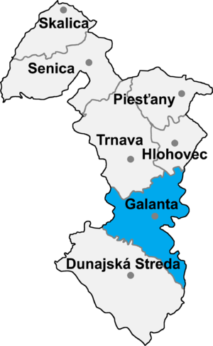
in Galanta District
Galanta District
Galanta District is adistrict inthe Trnava Region of western Slovakia.Until 1918, the district was mostly part of theHungarian countyof Pozsony , apart from a smallarea in the east, which formed part ofNyitra county....
of the Trnava Region
Trnava Region
The Trnava Region is one of the eight Slovak administrative regions.-Geography:It is located in the middlewest part of Slovakia and forms a territorial band between the Bratislava Region and the rest of Slovakia, between Austrian and Czech borders in the north and Hungarian border in the south...
of south-west Slovakia
Slovakia
The Slovak Republic is a landlocked state in Central Europe. It has a population of over five million and an area of about . Slovakia is bordered by the Czech Republic and Austria to the west, Poland to the north, Ukraine to the east and Hungary to the south...
.
Facts
Veľké Úľany is located in the southwest part of Slovakia, between Malý Dunaj and Čierna voda. Its population is about 5500. The village is situated near the Bratislava-Senec-Nitra main road. Veľké Úľany is located 15 kilometres in the south-east direction from Senec and 12 km in the south-west direction from Galanta.The first written reference: 1221 - under the name Fudemus
Area: 4185 ha
Villageregions: Veľké Úľany, Lencsehely, Sedín, Hajmáš
Public health: Local doctor (GP), paediatrician, gynaecologist, two dentists, pharmacy
Churches: Catholic, Evangelical
Schools: Borsos Mihály Primary School with Hungarian Language of Teaching, Kindergarten with Hungarian Language of Education, Primary School with Slovak Language of Teaching, Kindergarten with Slovak Language of Education
History
In historical recordsHistory
History is the discovery, collection, organization, and presentation of information about past events. History can also mean the period of time after writing was invented. Scholars who write about history are called historians...
the village
Village
A village is a clustered human settlement or community, larger than a hamlet with the population ranging from a few hundred to a few thousand , Though often located in rural areas, the term urban village is also applied to certain urban neighbourhoods, such as the West Village in Manhattan, New...
was first mentioned in 1221. The boundary of village was settled since ancient times. The oldest provable settlement is from the beginning of the Hallstatt culture, and this is proved by a sepulchral mound which is typical of the Kalenderberg culture. The first reference to the village under the name of Fudemus was found in a deed dated 1221, and it belonged to the possessions of the Castle of Bratislava, later it belonged to the lordship of Bratislava. The next document is from 1422 referring to the village as Wyfedenes. On the tax list of the Pope it is listed as Fedemus. On 11 December in 1445 Valentín Temesközy became the landlord of the village. Between years 1490 - 1505 the soldiers of the emperor Maximilian I. looted the village several times. Between years 1828-1842 here was Mikuláš Lacsny's sugar factory which was the first sugar factory in the Central Europe. In 1808 was the village mentioned also on a Slovak name as Welky Fedýmeš. The settlement was struck by more natural disasters: in 1862 big flood, in 1865 fire, in 1866 cholera epidemic. In 1869 2121 inhabitants lived in the village, in 1900: 2705, in 1930: 3002, in 1948: 3258, and in 1970: 3854. Very interesting is the formation of the village's official name: during the Austro-Hungarian Dual Monarchy was Nagyfödémes, in the times of I.ČSR Veľký Fedýmeš, and from 1948 Veľké Úľany. More independent countries used to stand in the boundary of the village. The settlement Tehel was first mentioned in 1221 as Terra Tewel, later as Willa Tewel. The first datas from the settlement Lencsehely are from year 1386. Both villages were destroyed in the times of the Turkish campaign. In 1976 Nové Osady was annexed to Veľké Úľany. Nové Osady evolved from the union of former settlements Hajmáš and Sedín (originally Szőgyén), which were separated from Veľké Úľany in 1927 as Švehlovo with 307 inhabitants. In 1951 Švehlovo was renamed and it became Nové Osady. Between the years 1938 and 1945 Veľké Úľany and the whole region appertained to Hungary. Nowadays, the village also has got an agricultural character, but the handcrafted production also starts developing in the last few years.
Tourism
The most important sight of the village is the Calvary, what was built on the hill near the cemetery. It has got an atrium with pear-shaped ground-plan. The entrance is on the west side of the Calvary. There are cavities like small chapels on the south and the north side of the Calvary's wall, on either side by 7. These cavities also stand out to the court. At the tip of the pear-shaped atrium is a chapel of Madonna which was built in classicistic style in 1756. The stations of the Cross were built by Ladislav Molnár and widow Mária Deáková in 1900. At the same time, during the activities of parson Karol Méhes from Nyék, the old chapel also was renovated. There stand on the both sides of the entrance the baroque sculpture of Madonna and Saint John the Evangelist respectively. Both sculptures are from the second third part of the 18th century. There is in the middle of the atrium a stone cross with inscription: Ex voto Matkovics Andre(:) 1773. The reconstruction of the Calvary in 2004 was sponsored from the financial resources of SAPARD. The Roman Catholic church of the archangel St. Michael was started to build in Renaissance style in 1594. According to data, the church was completed just in 1670. In 1718 there was added the tall tower to the church, the choir was made in 1750. A side aisle was added to the church in 1756. It was renovated in 1958. The painting of the vault was made in the beginning of the 20th century, and these paintings represent some details from the life of the saints. The altar of the archangel St. Michael with pillared architecture consist of central sculpture of the archangel, the relief which represents the Christ's christening and the relief which represents the obeisance of the three Kings. The side-altar of the Pieta with a Neogothic style is from the first part of the 19th century and the central figure of the side-altar is the little statue of the saint. The side-altar of the St. Joseph with Neogothic style is from the first part of the 19th century and there is the central figure of the saint. The side-altar of the Saint Cross also is in Neogothic style. The painting of the archangel St. Michael is from the 18th century, the picture of St. Anna is from 1876 and the paintings of the Madonna and the Holy Trinity are from the second part of the 19th century. The evangelical church was established in 1958 from one of the farm-buildings of the Pálffy's estate on the initiative of the Slovak settlers. The bell in the churchtower is from Brašljanica (Bulgaria). The building of the evangelical rectory is joined to the church. This building was put from the residence of the estate manager of the Pálffy's estate and this house was built in classicistic style at the beginning of the 19th century. The mansion is in the middle of the village, in the vicinity of the evangelical rectory. It is a building in classicistic style and it was built in 1828 by Mikuláš Lacsny. The building did not survive completely, its side-wing looking out onto the street was longer originally. The building is single-storey, its ground-plan has got a form as the letter L. There is an opened arcadic corridor in the courtyard-part of the annexe. The main facade of the mansion is divided by rectangular windows with plastic-framing. The original wrought-iron window grilles remained on the windows. The oldest and most valuable memory of the folk-building is the historical house with house number 726. It is a little, three-room building, with a board peak and with a gable roof covered with straw. It was built in the middle of the 19th century. The furniture of the house is typical of the 20th century. There is a draw well on the courtyard. In 1973 there was built up the holiday camp Modrá Perla (Blue Pearl). This is a complex, which consist of health-resort, football field, and in the neighbourhood is a sauna. There is a board and lodging possibility for 40 persons.Geography
The municipalityMunicipality
A municipality is essentially an urban administrative division having corporate status and usually powers of self-government. It can also be used to mean the governing body of a municipality. A municipality is a general-purpose administrative subdivision, as opposed to a special-purpose district...
lies at an elevation
Elevation
The elevation of a geographic location is its height above a fixed reference point, most commonly a reference geoid, a mathematical model of the Earth's sea level as an equipotential gravitational surface ....
of 123 metres and covers an area
Area
Area is a quantity that expresses the extent of a two-dimensional surface or shape in the plane. Area can be understood as the amount of material with a given thickness that would be necessary to fashion a model of the shape, or the amount of paint necessary to cover the surface with a single coat...
of 14.856 km². It has a population
Population
A population is all the organisms that both belong to the same group or species and live in the same geographical area. The area that is used to define a sexual population is such that inter-breeding is possible between any pair within the area and more probable than cross-breeding with individuals...
of about 5500 people.
External links
- http://www.statistics.sk/mosmis/eng/run.html
- http://www.velkeulany.sk/