
Vardenis
Encyclopedia
Vardenis.
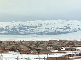
The town of Vardenis occupies the south-eastern corner of Gegharkunik province (marz
) of the Republic of Armenia
. The town is located in the valley of the Masrik river, on the territory of the Masrik artesian basin at a height of 1943 meters above sea level. It is 170 km from the capital Yerevan
, and 75 km from the provincial centre Gavar
. The administrative territory of Vardenis comprises 3006ha, of which 736ha is occupied by the town itself. Vardenis got its status as a urban settlement in 1995.
and it is directly affected by its proximity.
vary between 0.28-0.32g. In the city centre, the acceleration is 0.32g (8.5 magnitude), in the southern and eastern parts the magnitude reaches up to 8.25-8.5.
The town is at the proximity of Sevan National Park
which is very rich in biodiversity.
The Zangezur range is made up of paleogenic granitoids, volcanic and sedimentary deposits. In general, Syunik region is rich in mineral resources, including stones and metals.
The mineral resources of Vardenis can be classified as follows:
Masrik river runs through the northern part of the city. The horizon of the ground waters of this artesian basin lies 1.5-5m deep, which together with the horizon of weak pressured waters creates a joint water-bearing horizon. The fluctuations in the water level are between 0.24m and 0.57m.
Water in Vardenis is supplied by "Akunk", "Shat Jrer" and "Akner" water-pipe systems. The pipes of inner system and captation are currently in quite poor technical and sanitation condition.
The summer is short and mild, sunny, relatively humid, with minimal precipitation. The average minimum temperature of July–August is 160C. while the maximum makes up to 350C. Wind direction in the town and the whole region is stable. Eastern direction prevails during the whole year. The autumn is mild, first half is moderately cloudy, the second half is unstable.
Meteorological observations of the town (air temperature, precipitation, atmospheric pressure, relative humidity, absolute humidity, wind direction and speed etc.) are implemented by Vardenis-Masrik meteorological stations, established in the 1940s on 1842.7m above sea level.
 The current territory of Vardenis (formerly named Vasakashen, Voskeshen, Basargechar) occupies part of the historic Sotk county of Syunik
province. According to legends, the settlement was founded by Gegham, the grandson of the legendary Hayk and named Geghamabak. According to the historian Ghevond Alishan, Gaburn Vasak, the prince of Syunik, founded a settlement on this territory in 9th century AD. which was known as Vasakashen until the 17th century. After the fall of the Arshakuni dynasty, the county of Sotk was transferred to the dynasty of Smbatyan, prince of Vaykunk (Tsar) in the county of Artsakh
. During the raids of various nomadic tribes, the settlement was renamed Basargechar (perhaps meaning "trodden and passed", or related to the name "Basar", presumably of one of the leaders). In the 19th century, many Armenians fro the area migrated to Georgia
. In 1829—1830, the settlement was re-inhabited by Armenian migrants from Diadin (Tateon) in Western Armenia
. In 1930-1995 it became an administrative centre. In 1969 the name was changed from Basargeshar to Vardenis. The first general urban plan of Vardenis was applied in 1952. The updated plan of the town, including the community lands, was developed by the requirement of the Ministry of Urban Planning of the Republic of Armenia in 2004.
Vardenis is one of the oldest settlements in Armenia. The town and its vicinities are rich in cultural heritage with 568 monuments recorded. The most interesting are Makenats monastery, the basilica
in Sotk, the chapels of Ayrk, Karchaghbyur, as well as numerous other chapels, the tombs of 3-1 millennia BC, the Cyclopean masonry
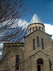
, and the medieval khachkars (cross-stones). In the centre of Vardenis, there is the Church of Surb Astvatsatsin (Holy Mother of God), built in 1905, where the Armenian historian Hovhannes Tsaretsi worked. The church is surrounded with numerous khachkars dating back to the 14th and the 17th centuries.
 During the Soviet period the Vardenis region had a mixed population of Armenians and Azerbaijanis. In 1988, as a result of the conflict
between Azerbaijan and Armenia, its ethnic Azeri population left for Azerbaijan and was replaced by ethnic Armenian refugees who were forced to leave the Azerbaijani territories. According to the 2001 census, the population of Vardenis comprised 13,700. Deterioration of economic potential, difficult financial situation, high unemployment rates and other problems resulted in decrease of the population. In comparison with 1996, the population has decreased by 2250 people, mainly due to youth migration and consequently, low birth rates.
The population is mainly engaged in agriculture, trade and services. The Sotk gold mine which is considered to be one of the largest deposits in Armenia is located 10 km west of the city. Many small dairy and bakery enterprises are still functioning in Vardenis since the Soviet times.
whose father philologist "Hamazasp Hambardzumyan" was a native of Varden
 Early Modern France, Romans-sur-Isère
Football club Lernagorts Vardenis
was the only club of the town. It was forced to dissolve in 1995 due to financial difficulties.
The town of Vardenis occupies the south-eastern corner of Gegharkunik province (marz
Marz
Marz may refer to:people* Ron Marz, comic book author* Richard Marz, Canadian politician* Marz , an American rapperother* Marz , the first order administrative division of Armenia...
) of the Republic of Armenia
Armenia
Armenia , officially the Republic of Armenia , is a landlocked mountainous country in the Caucasus region of Eurasia...
. The town is located in the valley of the Masrik river, on the territory of the Masrik artesian basin at a height of 1943 meters above sea level. It is 170 km from the capital Yerevan
Yerevan
Yerevan is the capital and largest city of Armenia and one of the world's oldest continuously-inhabited cities. Situated along the Hrazdan River, Yerevan is the administrative, cultural, and industrial center of the country...
, and 75 km from the provincial centre Gavar
Gavar
Gavar , is a city and the provincial capital of the Armenian province of Gegharkunik. It was known as Nor Bayezet or Novyi Bayazet until 1959, then Kamo until 1996...
. The administrative territory of Vardenis comprises 3006ha, of which 736ha is occupied by the town itself. Vardenis got its status as a urban settlement in 1995.
Topography
Vardenis is located on the slopes of 82 km range of Vardenis mountains. The highest peak, also named Vardenis, is 3522m. To the north-east, west and south-east of the town there are numerous roads to different parts of Armenia. The town is also bordered by the range of Sevan mountains. Vardenis is 5 km aways from Lake SevanLake Sevan
Lake Sevan is the largest lake in Armenia and the Caucasus region. It is one of the largest high-altitude lakes in the world.Lake Sevan is situated in the central part of the Republic of Armenia, inside the Gegharkunik Province, at the altitude of 1,900m above sea level...
and it is directly affected by its proximity.
Geology
The town of Vardenis is situated on the Masrik plain, in the valley of Masrik river. From the north it is bordered by Lake Sevan, from the east by Zangezur mountains and from the south-east by Vardenis mountains. From morphological point of view, Masrik represents an intermontane area filled with fluvial-lacustrian deposits. The major part of the city, i.e. alluvial-proluvial-accumulative plain, is presented by claysands, clays, sands, several subsoils. The south-eastern part of the town sits on erosion-denudational slopes, presented by slightly eroded, poriferous basalt. On the whole territory of Vardenis there is no active tectonic rifts. The projected earthquake accelerationPeak ground acceleration
Peak ground acceleration is a measure of earthquake acceleration on the ground and an important input parameter for earthquake engineering, also known as the design basis earthquake ground motion...
vary between 0.28-0.32g. In the city centre, the acceleration is 0.32g (8.5 magnitude), in the southern and eastern parts the magnitude reaches up to 8.25-8.5.
The town is at the proximity of Sevan National Park
Sevan National Park
Sevan National Park in Armenia was established in 1978 to protect Lake Sevan and the surrounding areas. Sevan National Park falls under the jurisdiction of the Ministry of Nature Protection, and is managed as a research center, which monitors the ecosystems, and undertakes various conservation...
which is very rich in biodiversity.
Mineral Resources
The area of Vardenis is rich with metal and non-metal resources. The gold mine of Sotk is active. There are numerous types of rock used in construction, as well as mines of semi-precious stones.The Zangezur range is made up of paleogenic granitoids, volcanic and sedimentary deposits. In general, Syunik region is rich in mineral resources, including stones and metals.
The mineral resources of Vardenis can be classified as follows:
| Mineral Resource | Location |
|---|---|
| Limestone | Location >Sarinar, Shishkaya, Lernasar |
| Travertines | Location >Yenokavank |
| Marble | Location >Tsakhkasar |
| Clays | Location >Karchaghbyur, Mets Mazra, Vardenis |
| Vulcanic auriferous pumice | Location >Pambak, Dara, Sevjur |
| Semiprecious stones | Location >Karagyugh, Lernasar, Lernantskayin |
| Auriferous peat | Location >Masrik, Gilli, Torfavan |
| Auriferous gray coal | Location >Sotk |
| Magnesium ore | Location >Jil, Babajan, Dara |
| Chromite ore | Location >Jil, Yefimovka, Chatindara, Pambak, Dara, Vahar, Sevjur, Vardenis, Kochkara, Lernasar |
| Nikel and cobalt ore | Location >Tigranaberd, Lernasar |
| Mercury ore | Location >Vaghar, Kaputsar (Burastan), Sevjur |
| Copper | Location >Tigranaberd |
| Mixed metal ore | Location >Sotk, Tsarasar |
| Platinum | Location >Jil, Babajan, Kakhakn (Karayman), Sotk |
Water Resources
Gegharkunik province is rich in water resources (surface, ground fresh and mineral waters). Water resources of the whole province comprise 692.29 thousand m3/day. Water resources of Vardenis area are 247.804 m3/day, of which 114.640 m3/day are subject to use.Masrik river runs through the northern part of the city. The horizon of the ground waters of this artesian basin lies 1.5-5m deep, which together with the horizon of weak pressured waters creates a joint water-bearing horizon. The fluctuations in the water level are between 0.24m and 0.57m.
Water in Vardenis is supplied by "Akunk", "Shat Jrer" and "Akner" water-pipe systems. The pipes of inner system and captation are currently in quite poor technical and sanitation condition.
Climate
Vardenis is located 1943 meters above sea level, with mild summers and cold winters. The average winter temperature is –60C. The winter actually lasts for 6 months and the number of days with temperatures below zero prevail. The snow falls in November and melts in mid-April. Vardenis is known for high insolation with 2500–2700 hours annually. Precipitation comprises 400–500 mm. Number of blizzard days is 30, of which 13 in January.The summer is short and mild, sunny, relatively humid, with minimal precipitation. The average minimum temperature of July–August is 160C. while the maximum makes up to 350C. Wind direction in the town and the whole region is stable. Eastern direction prevails during the whole year. The autumn is mild, first half is moderately cloudy, the second half is unstable.
Meteorological observations of the town (air temperature, precipitation, atmospheric pressure, relative humidity, absolute humidity, wind direction and speed etc.) are implemented by Vardenis-Masrik meteorological stations, established in the 1940s on 1842.7m above sea level.
Historical and Cultural Heritage
Syunik
Syunik is the southernmost province of Armenia. It borders the Vayots Dzor marz to the north, Azerbaijan's Nakhchivan exclave to the west, Karabakh to the east, and Iran to the south. Its capital is Kapan. Other important cities and towns include Goris, Sisian, Meghri, Agarak, and Dastakert...
province. According to legends, the settlement was founded by Gegham, the grandson of the legendary Hayk and named Geghamabak. According to the historian Ghevond Alishan, Gaburn Vasak, the prince of Syunik, founded a settlement on this territory in 9th century AD. which was known as Vasakashen until the 17th century. After the fall of the Arshakuni dynasty, the county of Sotk was transferred to the dynasty of Smbatyan, prince of Vaykunk (Tsar) in the county of Artsakh
Artsakh
Artsakh was the tenth province of the Kingdom of Armenia from 189 BC until 387 AD and afterwards a region of Caucasian Albania from 387 to the 7th century. From the 7th to 9th centuries, it fell under Arab control...
. During the raids of various nomadic tribes, the settlement was renamed Basargechar (perhaps meaning "trodden and passed", or related to the name "Basar", presumably of one of the leaders). In the 19th century, many Armenians fro the area migrated to Georgia
Georgia (country)
Georgia is a sovereign state in the Caucasus region of Eurasia. Located at the crossroads of Western Asia and Eastern Europe, it is bounded to the west by the Black Sea, to the north by Russia, to the southwest by Turkey, to the south by Armenia, and to the southeast by Azerbaijan. The capital of...
. In 1829—1830, the settlement was re-inhabited by Armenian migrants from Diadin (Tateon) in Western Armenia
Western Armenia
Western Armenia is a term, primarily used by Armenians, to refer to Armenian-inhabited areas of the Armenian Highland that were part of the Ottoman Empire and now are part of the Republic of Turkey....
. In 1930-1995 it became an administrative centre. In 1969 the name was changed from Basargeshar to Vardenis. The first general urban plan of Vardenis was applied in 1952. The updated plan of the town, including the community lands, was developed by the requirement of the Ministry of Urban Planning of the Republic of Armenia in 2004.
Vardenis is one of the oldest settlements in Armenia. The town and its vicinities are rich in cultural heritage with 568 monuments recorded. The most interesting are Makenats monastery, the basilica
Basilica
The Latin word basilica , was originally used to describe a Roman public building, usually located in the forum of a Roman town. Public basilicas began to appear in Hellenistic cities in the 2nd century BC.The term was also applied to buildings used for religious purposes...
in Sotk, the chapels of Ayrk, Karchaghbyur, as well as numerous other chapels, the tombs of 3-1 millennia BC, the Cyclopean masonry
Cyclopean masonry
Cyclopean masonry is a type of stonework found in Mycenaean architecture, built with huge limestone boulders, roughly fitted together with minimal clearance between adjacent stones and no use of mortar...
, and the medieval khachkars (cross-stones). In the centre of Vardenis, there is the Church of Surb Astvatsatsin (Holy Mother of God), built in 1905, where the Armenian historian Hovhannes Tsaretsi worked. The church is surrounded with numerous khachkars dating back to the 14th and the 17th centuries.
Population and economy
Nagorno-Karabakh War
The Nagorno-Karabakh War was an armed conflict that took place from February 1988 to May 1994, in the small enclave of Nagorno-Karabakh in southwestern Azerbaijan, between the majority ethnic Armenians of Nagorno-Karabakh backed by the Republic of Armenia, and the Republic of Azerbaijan...
between Azerbaijan and Armenia, its ethnic Azeri population left for Azerbaijan and was replaced by ethnic Armenian refugees who were forced to leave the Azerbaijani territories. According to the 2001 census, the population of Vardenis comprised 13,700. Deterioration of economic potential, difficult financial situation, high unemployment rates and other problems resulted in decrease of the population. In comparison with 1996, the population has decreased by 2250 people, mainly due to youth migration and consequently, low birth rates.
The population is mainly engaged in agriculture, trade and services. The Sotk gold mine which is considered to be one of the largest deposits in Armenia is located 10 km west of the city. Many small dairy and bakery enterprises are still functioning in Vardenis since the Soviet times.
Education & Sports
Vardenis has 4 public education schools and 3 kindergartens. The town is also home to the house-museum of Viktor HambardzumyanViktor Hambardzumyan
Viktor Hambardzumyan was a Soviet Armenian scientist, and one of the founders of theoretical astrophysics. He worked in the field of physics of stars and nebulae, stellar astronomy, dynamics of stellar systems and cosmogony of stars and galaxies, contributed to Mathematical physics...
whose father philologist "Hamazasp Hambardzumyan" was a native of Varden
Sister City
Early Modern France, Romans-sur-IsèreRomans-sur-Isère
Romans-sur-Isère or Romans is a commune in the Drôme department in southeastern France.-Geography:...
Football club Lernagorts Vardenis
Lernagorts Vardenis
Lernagorts Vardenis was an Armenian football club from Vardenis. The club dissolved in 1995 and is currently inactive from professional football.-League Record :...
was the only club of the town. It was forced to dissolve in 1995 due to financial difficulties.