

Utah State Route 92
Encyclopedia
State Route 92, or the Alpine Loop Scenic Byway, is a scenic state highway
in Utah County, Utah
that runs from I-15/US-89 near Highland
to US-189 in Provo Canyon
. The route is approximately 27 miles (43.5 km) long and is the only road with access to Sundance Ski Resort and the Aspen Grove Family Camp and Conference Center sponsored by the Brigham Young University Alumni Association.
 The route runs east from Highland and up American Fork Canyon
, where it enters the Uinta National Forest
. Shortly after, it passes Timpanogos Cave National Monument
, a famous group of caves buried in the side of the canyon. The route continues up the canyon and bends to the south where it passes the east side of Mount Timpanogos
. After passing Sundance Ski Resort, the road links up with US-189 in Provo Canyon
.
boundary in American Fork Canyon
, replacing a short piece of SR-146 (created in 1933) from SR-74 to the mouth of the canyon. At the other end of the highway, State Route 168 was built in 1933 as a forest road and numbered in 1935, connecting SR-7 (US-189) with Aspen Grove. SR-80 was extended through the forest to SR-7, absorbing SR-168, in 1953. Because the number 80 was needed for I-80, SR-80 was renumbered SR-92 in the 1977 renumbering.
State highway
State highway, state road or state route can refer to one of three related concepts, two of them related to a state or provincial government in a country that is divided into states or provinces :#A...
in Utah County, Utah
Utah County, Utah
Utah County is a county located in the U.S. state of Utah. As of 2000, the population was 368,536 and by 2008 was estimated at 530,837. It was named for the Spanish name for the Ute Indians. The county seat and largest city is Provo...
that runs from I-15/US-89 near Highland
Highland, Utah
Highland is a city in Utah County, Utah, United States. It is approximately thirty miles from Salt Lake City and is part of the Provo–Orem, Utah Metropolitan Statistical Area. According to the 2010 census the population was 15,523, a 90.0% increase over the 2000 figure of 8,172...
to US-189 in Provo Canyon
Provo Canyon
Provo Canyon is a canyon located in unincorporated Utah County, Utah, USA and Wasatch County, Utah. Provo Canyon splits between Mount Timpanogos on the north and Mount Cascade on the south. The canyon extends from Orem on the west end to Heber City on the east. The canyon's main thoroughfare is...
. The route is approximately 27 miles (43.5 km) long and is the only road with access to Sundance Ski Resort and the Aspen Grove Family Camp and Conference Center sponsored by the Brigham Young University Alumni Association.
Route description
American Fork Canyon
American Fork Canyon is a canyon located in the Wasatch Mountains of Utah. The canyon is famous for the Timpanogos Cave National Monument, which resides on its south side...
, where it enters the Uinta National Forest
Uinta National Forest
Uinta National Forest is a national forest located in north central Utah, USA. It was originally part of the Uinta Forest Reserve, created by Grover Cleveland on February 2, 1897. The name is derived from the Ute word Yoov-we-teuh which means pine forest...
. Shortly after, it passes Timpanogos Cave National Monument
Timpanogos Cave National Monument
Timpanogos Cave National Monument is a cave system in the Wasatch mountains in American Fork Canyon near American Fork, Utah, in the United States. The 1.5 mile trail to the cave is steep at several points, but paved and wide, so the cave opening is accessible to most...
, a famous group of caves buried in the side of the canyon. The route continues up the canyon and bends to the south where it passes the east side of Mount Timpanogos
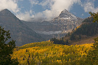
Mount Timpanogos
Mount Timpanogos, sometimes informally referred to as Timp, is the second highest mountain in Utah's Wasatch Range. Timpanogos rises to an elevation of 11,749 feet above sea level in the Uinta National Forest...
. After passing Sundance Ski Resort, the road links up with US-189 in Provo Canyon
Provo Canyon
Provo Canyon is a canyon located in unincorporated Utah County, Utah, USA and Wasatch County, Utah. Provo Canyon splits between Mount Timpanogos on the north and Mount Cascade on the south. The canyon extends from Orem on the west end to Heber City on the east. The canyon's main thoroughfare is...
.
History
The state legislature created State Route 80 in 1935, connecting SR-1 (US-91, now I-15/US-89) near Point of the Mountain with SR-74 south of Alpine. An extension in 1941 took SR-92 east to the Uinta National ForestUinta National Forest
Uinta National Forest is a national forest located in north central Utah, USA. It was originally part of the Uinta Forest Reserve, created by Grover Cleveland on February 2, 1897. The name is derived from the Ute word Yoov-we-teuh which means pine forest...
boundary in American Fork Canyon
American Fork Canyon
American Fork Canyon is a canyon located in the Wasatch Mountains of Utah. The canyon is famous for the Timpanogos Cave National Monument, which resides on its south side...
, replacing a short piece of SR-146 (created in 1933) from SR-74 to the mouth of the canyon. At the other end of the highway, State Route 168 was built in 1933 as a forest road and numbered in 1935, connecting SR-7 (US-189) with Aspen Grove. SR-80 was extended through the forest to SR-7, absorbing SR-168, in 1953. Because the number 80 was needed for I-80, SR-80 was renumbered SR-92 in the 1977 renumbering.