

Usoi Dam
Encyclopedia
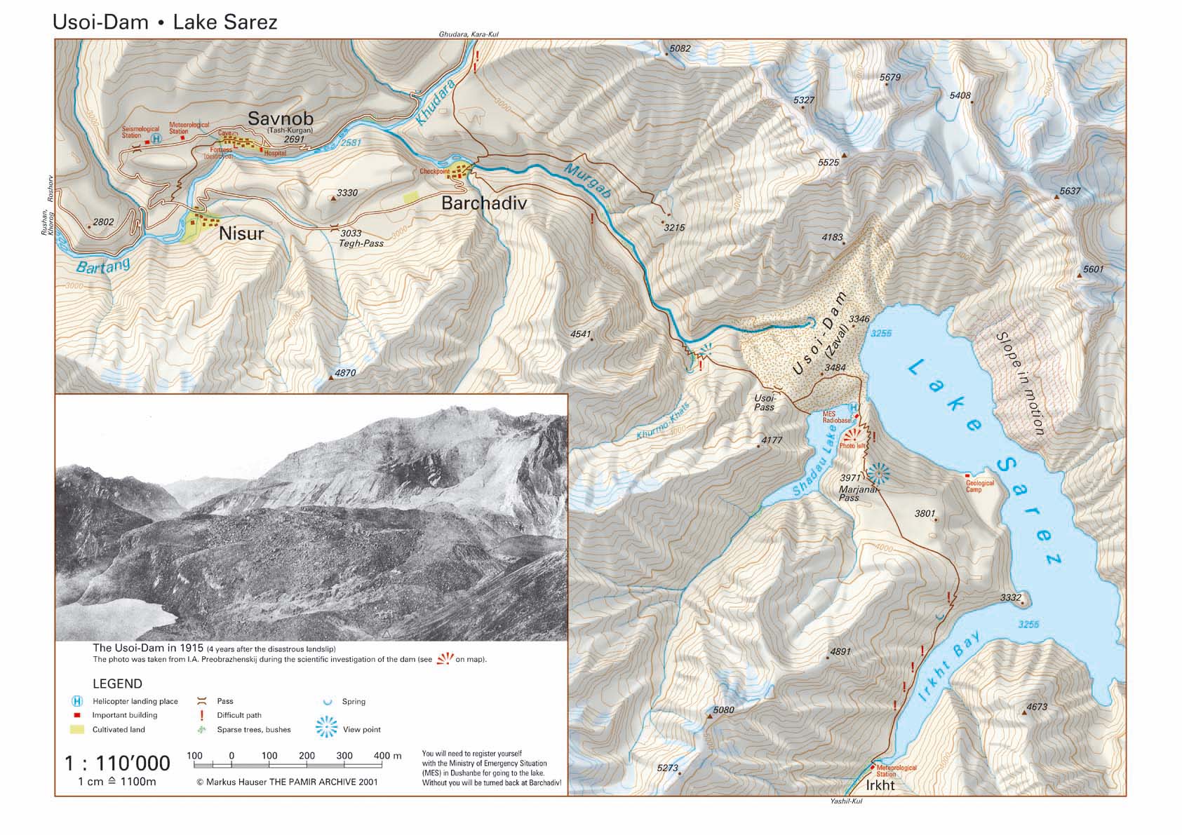
The Usoi Dam is a natural landslide dam
along the Murghab River in the Central Asian country of Tajikistan
. At 567 metres (1,860.2 ft) high, it is the tallest dam in the world, either natural or man-made. The dam was created on February 18, 1911, when the 7.4-Ms
Sarez earthquake
caused a massive landslide
that blocked the flow of the river.
The dam is formed of approximately 2 cubic kilometre (0.479825517208573 cu mi) of rock dislodged from the steeply sloped river valley of the Murghab, which cuts from east to west through the high and rough Pamir Mountains
. It is named after the village of Usoi, which was completely buried by the 1911 landslide. The dam rises to a height of 500 to 700 m (1,640.4 to 2,296.6 ft) from the original valley floor.
The basin formed by Usoi Dam now holds Sarez Lake
, a 55.8 kilometres (34.7 mi)-long lake holding 16.074 cubic kilometre of water. Water does not flow over the top of the dam, which would quickly cause it to erode away; instead, water seeps out of the base of the dam at a rate which approximately matches the rate of inflow, maintaining the lake at a relatively constant level.
Geologists are concerned that the Usoi Dam may become unstable during future large-magnitude earthquakes, which are relatively common in the seismically active Pamirs, and might collapse due to liquefaction
or subsequent landslides during such an event. Collapse of the dam would unleash a locally catastrophic flood, as the Murghab's river valley tends to be relatively narrow and steep, which would focus and maintain any flood's destructive power.
Landslide dam
A landslide dam, debris dam, or barrier lake is a natural damming of a river by some kind of mass wasting: landslide, debris flow, rock avalanche or volcano. If it is caused by earthquake, it may also be called a quake lake. Some landslide dams are as high as the largest existing artificial dam...
along the Murghab River in the Central Asian country of Tajikistan
Tajikistan
Tajikistan , officially the Republic of Tajikistan , is a mountainous landlocked country in Central Asia. Afghanistan borders it to the south, Uzbekistan to the west, Kyrgyzstan to the north, and China to the east....
. At 567 metres (1,860.2 ft) high, it is the tallest dam in the world, either natural or man-made. The dam was created on February 18, 1911, when the 7.4-Ms
Surface wave magnitude
The surface wave magnitude scale is one of the magnitude scales used in seismology to describe the size of an earthquake. It is based on measurements in Rayleigh surface waves that travel primarily along the uppermost layers of the earth...
Sarez earthquake
1911 Sarez earthquake
The 1911 Sarez earthquake occurred at 18:41 UTC on 18 February in the central Pamir Mountains in the Rushon District of eastern Tajikistan. It had an estimated magnitude of 7.4 on the surface wave magnitude scale and a maximum felt intensity of about IX on the Mercalli intensity scale...
caused a massive landslide
Landslide
A landslide or landslip is a geological phenomenon which includes a wide range of ground movement, such as rockfalls, deep failure of slopes and shallow debris flows, which can occur in offshore, coastal and onshore environments...
that blocked the flow of the river.
The dam is formed of approximately 2 cubic kilometre (0.479825517208573 cu mi) of rock dislodged from the steeply sloped river valley of the Murghab, which cuts from east to west through the high and rough Pamir Mountains
Pamir Mountains
The Pamir Mountains are a mountain range in Central Asia formed by the junction or knot of the Himalayas, Tian Shan, Karakoram, Kunlun, and Hindu Kush ranges. They are among the world’s highest mountains and since Victorian times they have been known as the "Roof of the World" a probable...
. It is named after the village of Usoi, which was completely buried by the 1911 landslide. The dam rises to a height of 500 to 700 m (1,640.4 to 2,296.6 ft) from the original valley floor.
The basin formed by Usoi Dam now holds Sarez Lake
Sarez Lake
-External links:****...
, a 55.8 kilometres (34.7 mi)-long lake holding 16.074 cubic kilometre of water. Water does not flow over the top of the dam, which would quickly cause it to erode away; instead, water seeps out of the base of the dam at a rate which approximately matches the rate of inflow, maintaining the lake at a relatively constant level.
Geologists are concerned that the Usoi Dam may become unstable during future large-magnitude earthquakes, which are relatively common in the seismically active Pamirs, and might collapse due to liquefaction
Liquefaction
Liquefaction may refer to:* Liquefaction, the general process of becoming liquid* Soil liquefaction, the process by which sediments become suspended* Liquefaction of gases in physics, chemistry, and thermal engineering* Liquefactive necrosis in pathology...
or subsequent landslides during such an event. Collapse of the dam would unleash a locally catastrophic flood, as the Murghab's river valley tends to be relatively narrow and steep, which would focus and maintain any flood's destructive power.