
United States Senate election in Indiana, 1994
Encyclopedia
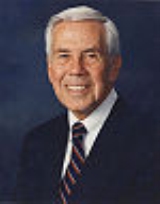
The 1994 United States Senate election in Indiana was held on November 8, 1994. Incumbent Republican U.S. Senator Richard Lugar was re-elected to a fourth term.
.
Overall
By county
Lugar won 91 of Indiana's 92 counties, Jontz won only the Democratic stronghold of Lake CountyLake County, Indiana
Lake County is a county located in the U.S. state of Indiana. In 2010, its population was 496,005, making it Indiana's second-most populous county. The county seat is Crown Point. This county is part of Northwest Indiana and the Chicago metropolitan area. The county contains a mix of urban,...
.
| County | Lugar | Votes | Jontz | Votes | Others | Votes | Total |
|---|---|---|---|---|---|---|---|
| Adams Adams County, Indiana Adams County lies in northeastern Indiana in the United States and shares its eastern border with Ohio. It was officially established in 1836. The county seat is Decatur.... |
69.7% | 6,957 | 28.2% | 2,812 | 2.1% | 209 | 9,978 |
| Allen Allen County, Indiana As of the census of 2000, there were 331,849 people, 128,745 households, and 86,259 families residing in the county. The population density was 505 people per square mile . There were 138,905 housing units at an average density of 211 per square mile... |
71.2% | 58,175 | 26.7% | 21,760 | 2.1% | 1,756 | 81,691 |
| Bartholomew Bartholomew County, Indiana Bartholomew County is a county located in the U.S. state of Indiana, and determined by the U.S. Census Bureau to include the mean center of U.S. population in 1900. As of 2010, the population was 76,794... |
72.9% | 14,746 | 25.2% | 5,085 | 1.9% | 378 | 20,209 |
| Benton Benton County, Indiana Benton County is located along in the northwest part of the U.S. state of Indiana, along the border with Illinois. As of 2010, the county's population was 8,854. It contains six incorporated towns as well as several small unincorporated settlements; it is also divided into 11 townships which... |
64.4% | 1,865 | 32.9% | 954 | 2.7% | 77 | 2,896 |
| Blackford Blackford County, Indiana Blackford County is located in the east central portion of the U.S. state of Indiana. The county is named for Judge Isaac Blackford, who was the first speaker of the Indiana General Assembly and a long-time chief justice of the Indiana Supreme Court. Created in 1838, Blackford County is divided... |
64.9% | 2,833 | 33.3% | 1,452 | 1.8% | 78 | 4,363 |
| Boone Boone County, Indiana As of the census of 2000, there were 46,107 people, 17,081 households, and 12,810 families residing in the county. The population density was 109 people per square mile . There were 17,929 housing units at an average density of 42 per square mile... |
80.8% | 10,096 | 17.7% | 2,207 | 1.5% | 189 | 12,492 |
| Brown Brown County, Indiana Brown County is a county located in the U.S. state of Indiana. As of 2010, the population is 15,242. The county seat is Nashville.- History :... |
69.3% | 3,400 | 27.4% | 1,345 | 3.3% | 163 | 4,908 |
| Carroll Carroll County, Indiana Carroll County is a county located in the U.S. state of Indiana. As of 2010, the population was 20,155. The county seat is Delphi.Carroll County is part of the Lafayette, Indiana, Metropolitan Statistical Area.- History :... |
64.0% | 4,026 | 33.2% | 2,088 | 2.8% | 176 | 6,290 |
| Cass Cass County, Indiana As of the census of 2000, there were 40,930 people, 15,715 households, and 10,921 families residing in the county. The population density was 99 people per square mile . There were 16,620 housing units at an average density of 40 per square mile... |
63.0% | 8,150 | 34.9% | 4,509 | 2.1% | 272 | 12,931 |
| Clark Clark County, Indiana Clark County is a county located in the U.S. state of Indiana, located directly across the Ohio River from Louisville, Kentucky. At the 2010 Census, the population was 110,232. The county seat is Jeffersonville. Clarksville is also a major city in the county... |
63.7% | 13,536 | 34.6% | 7,332 | 1.7% | 371 | 21,239 |
| Clay Clay County, Indiana Clay County is a county located in the U.S. state of Indiana. As of 2010, the population was 26,890. The county seat is Brazil. Clay County is included in the Terre Haute, Indiana, Metropolitan Statistical Area.- History :Clay County was formed in 1825... |
69.3% | 5,657 | 28.4% | 2,312 | 2.3% | 189 | 8,158 |
| Clinton Clinton County, Indiana As of the census of 2000, there were 33,866 people, 12,545 households, and 9,057 families residing in the county. The population density was 84 people per square mile . There were 13,267 housing units at an average density of 33 per square mile... |
71.0% | 6,321 | 27.0% | 2,408 | 2.0% | 180 | 8,909 |
| Crawford Crawford County, Indiana Crawford County is a county located in the U.S. state of Indiana. As of 2010, the population was 10,713. The county seat is English.-Geography:... |
62.3% | 2,754 | 35.9% | 1,588 | 1.8% | 80 | 4,422 |
| Daviess Daviess County, Indiana Daviess County is a county located in the U.S. state of Indiana. As of 2010, the population was 31,648. The county seat is Washington. Daviess County switched to the Central Time Zone on April 2, 2006. It has returned to the Eastern Time Zone as of November 4, 2007.- History :Daviess County was... |
75.4% | 6,008 | 23.2% | 1,850 | 1.4% | 112 | 7,970 |
| Dearborn Dearborn County, Indiana Dearborn County is a county located in the U.S. state of Indiana. As of 2010, the population was 50,047. It is part of the Cincinnati-Northern Kentucky metropolitan area. The county seat is Lawrenceburg.-History:... |
66.1% | 7,667 | 29.7% | 3,439 | 4.2% | 484 | 11,590 |
| Decatur Decatur County, Indiana As of the census of 2000, there were 24,555 people, 9,389 households, and 6,882 families residing in the county. The population density was 66 people per square mile . There were 9,992 housing units at an average density of 27 per square mile... |
75.2% | 6,184 | 22.6% | 1,850 | 2.2% | 184 | 8,218 |
| DeKalb DeKalb County, Indiana DeKalb County is a county located in the U.S. state of Indiana. Named for Revolutionary War hero Johann, Baron de Kalb , the county was created by the Indiana legislature in 1835 and organized in 1837. As of 2010, the population was 42,223... |
68.1% | 7,223 | 30.2% | 3,200 | 1.7% | 182 | 10,605 |
| Delaware Delaware County, Indiana As of the census of 2000, there were 118,769 people, 47,131 households, and 29,692 families residing in the county. The population density was 302 people per square mile . There were 51,032 housing units at an average density of 130 per square mile... |
66.4% | 24,703 | 31.7% | 11,771 | 1.9% | 712 | 37,186 |
| Dubois Dubois County, Indiana Dubois County is a county located in the U.S. state of Indiana. The county seat is Jasper. As of 2010, the population was 41,889.Dubois County is part of the Jasper Micropolitan Statistical Area.-History:... |
64.4% | 7,728 | 31.9% | 3,829 | 3.7% | 448 | 12,005 |
| Elkhart Elkhart County, Indiana Elkhart County is a county in the U.S. state of Indiana. Much of the county is in the Elkhart-Goshen Metropolitan Statistical Area, which in turn is part of the South Bend-Elkhart-Mishawaka Combined Statistical Area... |
78.0% | 23,475 | 20.1% | 6,045 | 1.9% | 573 | 30,093 |
| Fayette Fayette County, Indiana -2010 Census Data:As of the census of 2010, there were 24,277 people and 9,719 households residing in the county. The population density was 113 people per square mile . There were 10,898 housing units at an average density of 51 per square mile... |
66.7% | 5,218 | 31.9% | 2,497 | 1.4% | 111 | 7,826 |
| Floyd Floyd County, Indiana Floyd County is a county located in the U.S. state of Indiana. As of 2010, the population was 74,578. The county seat is New Albany. Floyd County is the county with the second smallest land area in the entire state... |
64.5% | 12,266 | 33.6% | 6,390 | 1.9% | 360 | 19,016 |
| Fountain Fountain County, Indiana Fountain County lies in the western part of the U.S. state of Indiana on the east side of the Wabash River. The county was officially established in 1826 and was the 53rd in Indiana. The county seat is Covington.... |
69.2% | 4,506 | 28.5% | 1,853 | 2.3% | 148 | 6,507 |
| Franklin Franklin County, Indiana As of the census of 2000, there were 22,151 people, 7,868 households, and 6,129 families residing in the county. The population density was 57 people per square mile . There were 8,596 housing units at an average density of 22 per square mile... |
67.8% | 4,637 | 29.1% | 1,993 | 3.1% | 213 | 6,843 |
| Fulton Fulton County, Indiana As of the census of 2000, there were 20,511 people, 8,082 households, and 5,738 families residing in the county. The population density was 56 people per square mile . There were 9,123 housing units at an average density of 25 per square mile... |
64.6% | 4,475 | 33.4% | 2,318 | 2.0% | 138 | 6,931 |
| Gibson Gibson County, Indiana Gibson County is a county located in the southwestern part of the U.S. state of Indiana and is included in the Evansville, Indiana–Kentucky Metropolitan Statistical Area. As of 2010, the population was 33,503. The county seat is Princeton.-Geography:... |
63.0% | 7,505 | 35.2% | 4,184 | 1.8% | 209 | 11,898 |
| Grant Grant County, Indiana Grant County is a county located in the U.S. state of Indiana. As of the 2010 census, the population was 70,061. The county seat is Marion. Important paleontological discoveries dating from the Pliocene epoch have been made at Pipe Creek Sinkhole in Grant County.-Geography:According to the 2010... |
64.0% | 12,609 | 34.6% | 6,802 | 1.4% | 280 | 19,691 |
| Greene Greene County, Indiana Greene County is a county located in the U.S. state of Indiana, and determined by the U.S. Census Bureau to include the mean center of U.S. population in 1930. As of 2010, the population was 33,165. The county seat is Bloomfield.... |
63.2% | 6,597 | 34.5% | 3,592 | 2.3% | 235 | 10,424 |
| Hamilton Hamilton County, Indiana Hamilton County is a county located in the U.S. state of Indiana. Census 2010 recorded a population of 274,569. The county seat is Noblesville.... |
87.3% | 30,103 | 10.9% | 3,731 | 1.8% | 634 | 34,468 |
| Hancock Hancock County, Indiana Hancock County is a county located in the U.S. state of Indiana. As of 2010, the population was 70,002. The county seat is Greenfield.-Geography:... |
79.0% | 10,880 | 18.6% | 2,560 | 2.4% | 324 | 13,764 |
| Harrison Harrison County, Indiana Harrison County is a county located in the far southern part of the U.S. state of Indiana along the Ohio River. It is divided into twelve townships, and the county seat is Corydon, the former capital of Indiana. The county is part of the larger Louisville/Jefferson County, KY–IN Metropolitan... |
66.1% | 6,703 | 31.3% | 3,172 | 2.6% | 265 | 10,140 |
| Hendricks Hendricks County, Indiana - Towns :*Amo*Avon*Brownsburg*Clayton*Coatesville*Danville*Lizton*North Salem*Pittsboro*Plainfield*Stilesville-Townships:*Brown*Center*Clay*Eel River*Franklin*Guilford*Liberty*Lincoln*Marion*Middle*Union*Washington-Further reading:... |
80.8% | 17,994 | 17.2% | 3,817 | 2.0% | 442 | 22,253 |
| Henry Henry County, Indiana As of the census of 2000, there were 48,508 people, 19,486 households, and 13,971 families residing in the county. The population density was 124 people per square mile . There were 20,592 housing units at an average density of 52 per square mile... |
69.2% | 10,014 | 29.1% | 4,219 | 1.7% | 243 | 14,476 |
| Howard Howard County, Indiana Howard County is one of 92 counties in the U.S. state of Indiana. It is part of the Kokomo, Indiana, Metropolitan Statistical Area, which consists of Howard and Tipton counties. Originally named Richardville County, it was rechristened in 1844 to commemorate General Tilghman Ashurst Howard. As of... |
66.1% | 17,119 | 31.6% | 8,188 | 2.3% | 583 | 25,890 |
| Huntington Huntington County, Indiana Huntington County is a county located in the U.S. state of Indiana. The county seat and lone city is Huntington. According to Census 2010, the population was 37,124.-Geography:... |
74.1% | 9,727 | 24.2% | 3,176 | 1.7% | 223 | 13,126 |
| Jackson Jackson County, Indiana Jackson County is a county located in the U.S. state of Indiana. As of 2010, the population was 42,376. The county seat is Brownstown.-History:... |
65.2% | 7,050 | 33.0% | 3,560 | 1.8% | 190 | 10,800 |
| Jasper Jasper County, Indiana As of the census of 2000, there were 30,043 people, 10,686 households, and 8,217 families residing in the county. The population density was 54 people per square mile . There were 11,236 housing units at an average density of 20 per square mile... |
68.3% | 4,227 | 30.4% | 1,884 | 1.3% | 81 | 6,192 |
| Jay Jay County, Indiana As of the census of 2000, there were 21,806 people, 8,405 households, and 6,017 families residing in the county. The population density was 57 people per square mile . There were 9,074 housing units at an average density of 24 per square mile... |
69.0% | 4,815 | 29.2% | 2,033 | 1.8% | 129 | 6,977 |
| Jefferson Jefferson County, Indiana Jefferson County is a county located in the U.S. state of Indiana. As of 2010, the population was 32,428. The county seat is Madison.-History:Jefferson County was formed in 1811... |
65.1% | 6,068 | 32.8% | 3,050 | 2.1% | 192 | 9,310 |
| Jennings Jennings County, Indiana Jennings County is a county located in the U.S. state of Indiana. As of 2010, the population was 28,525. The county seat is Vernon.-History:... |
66.5% | 4,898 | 32.3% | 2,298 | 2.2% | 164 | 7,360 |
| Johnson Johnson County, Indiana As of the census of 2000, there were 115,209 people, 42,434 households, and 31,613 families residing in the county. The population density was 360 people per square mile . There were 45,095 housing units at an average density of 141 per square mile... |
80.2% | 20,650 | 17.5% | 4,490 | 2.3% | 582 | 25,722 |
| Knox Knox County, Indiana As of the census of 2000, there were 39,256 people, 15,552 households, and 10,139 families residing in the county. The population density was 76 people per square mile . There were 17,305 housing units at an average density of 34 per square mile... |
66.0% | 8,155 | 32.0% | 3,953 | 2.0% | 255 | 12,363 |
| Kosciusko Kosciusko County, Indiana Kosciusko County is a county located in the U.S. state of Indiana. Census 2010 recorded the population at 77,358. The county seat is Warsaw.The county was formed in 1836. It was named after the Polish general Tadeusz Kościuszko, who served in the American Revolutionary War, and then returned to... |
78.7% | 13,039 | 19.7% | 3,269 | 1.6% | 261 | 16,569 |
| LaGrange LaGrange County, Indiana LaGrange County is a county located in the U.S. state of Indiana and in the Northern Indiana region known as Michiana. As of 2010, the population was 37,128. The county is located about east of South Bend, west of Toledo, Ohio, and northeast of Indianapolis. The area is well known for its large... |
75.1% | 4,195 | 23.3% | 1,299 | 1.6% | 88 | 5,582 |
| Lake Lake County, Indiana Lake County is a county located in the U.S. state of Indiana. In 2010, its population was 496,005, making it Indiana's second-most populous county. The county seat is Crown Point. This county is part of Northwest Indiana and the Chicago metropolitan area. The county contains a mix of urban,... |
45.3% | 43,685 | 52.6% | 50,592 | 2.1% | 2,065 | 96,342 |
| LaPorte LaPorte County, Indiana LaPorte County is a county located in the U.S. state of Indiana. As of 2010, the population was 111,467. The county seat is the city of La Porte. This county is part of the Chicago metropolitan area, Northwest Indiana and Michiana. The largest city is Michigan City... |
65.3% | 19,357 | 32.0% | 9,479 | 2.7% | 814 | 29,650 |
| Lawrence Lawrence County, Indiana As of the census of 2000, there were 45,922 people, 18,535 households, and 13,141 families residing in the county. The population density was 102 people per square mile . There were 20,560 housing units at an average density of 46 per square mile... |
69.2% | 8,446 | 28.4% | 3,467 | 2.4% | 289 | 12,202 |
| Madison Madison County, Indiana As of the census of 2000, there were 133,358 people, 53,052 households, and 36,234 families residing in the county. The population density was 295 people per square mile . There were 56,939 housing units at an average density of 126 per square mile... |
63.3% | 27,434 | 34.8% | 15,055 | 1.9% | 810 | 43,299 |
| Marion Marion County, Indiana Marion County is a county located in the U.S. state of Indiana. Census 2010 recorded a population of 903,393, making it the largest county in the state and 55th most populated county in the country, greater than the population of six states. The county seat is Indianapolis, the state capital and... |
68.7% | 133,836 | 29.1% | 56,585 | 2.2% | 4,276 | 194,697 |
| Marshall Marshall County, Indiana As of the census of 2000, there were 45,128 people, 16,519 households, and 12,191 families residing in the county. The population density was 102 people per square mile . There were 18,099 housing units at an average density of 41 per square mile... |
73.0% | 7,929 | 25.5% | 2,770 | 1.5% | 158 | 10,857 |
| Martin Martin County, Indiana As of the census of 2000, there were 10,369 people, 4,183 households, and 2,877 families residing in the county. The population density was 31 people per square mile . There were 4,729 housing units at an average density of 14 per square mile... |
61.1% | 2,484 | 37.1% | 1,508 | 1.8% | 75 | 4,067 |
| Miami Miami County, Indiana As of the census of 2000, there were 36,082 people, 13,716 households, and 9,806 families residing in the county. The population density was 96 people per square mile . There were 15,299 housing units at an average density of 41 per square mile... |
66.8% | 6,146 | 31.2% | 2,868 | 2.0% | 188 | 9,202 |
| Monroe Monroe County, Indiana As of the census of 2010, there were 137,974 people, 46,898 households, and 24,715 families residing in the county. The population density was 306 people per square mile . There were 50,846 housing units at an average density of 129 per square mile... |
65.1% | 17,430 | 32.4% | 8,655 | 2.5% | 667 | 26,752 |
| Montgomery Montgomery County, Indiana Montgomery County is a county located in the U.S. state of Indiana. As of 2010, the population was 38,124. The county seat is Crawfordsville-Early history and settlement:... |
78.8% | 8,645 | 19.2% | 2,100 | 2.0% | 217 | 10,962 |
| Morgan Morgan County, Indiana Morgan County is a county located in the U.S. state of Indiana. As of 2010, the population was 68,894. The county seat is Martinsville. Morgan is one of seven counties contiguous to Marion County, and is located between Indianapolis, in Marion County, and Bloomington, located in Monroe County... |
77.6% | 11,865 | 20.0% | 3,059 | 2.4% | 364 | 15,288 |
| Newton Newton County, Indiana Newton County is a county located in the U.S. state of Indiana. As of 2010, the population was 14,244. The county seat is Kentland.- History :... |
56.4% | 2,316 | 41.4% | 1,696 | 2.2% | 91 | 4,103 |
| Noble Noble County, Indiana As of the census of 2000, there were 46,275 people, 16,696 households, and 12,288 families residing in the county. The population density was 113 people per square mile . There were 18,233 housing units at an average density of 44 per square mile... |
71.0% | 7,268 | 27.2% | 2,780 | 1.8% | 186 | 10,234 |
| Ohio Ohio County, Indiana As of the census of 2000, there were 5,623 people, 2,201 households, and 1,586 families residing in the county. The population density was 65 people per square mile . There were 2,424 housing units at an average density of 28 per square mile... |
59.0% | 1,308 | 36.7% | 813 | 4.3% | 95 | 2,216 |
| Orange Orange County, Indiana As of the census of 2000, there were 19,306 people, 7,621 households, and 5,342 families residing in the county. The population density was 48 people per square mile . There were 8,348 housing units at an average density of 21 per square mile... |
70.7% | 4,093 | 27.0% | 1,559 | 2.3% | 131 | 5,783 |
| Owen Owen County, Indiana Owen County is a county located in the U.S. state of Indiana, and determined by the U.S. Census Bureau to include the mean center of U.S. population in 1920. As of 2010, the population was 21,575... |
68.4% | 3,490 | 29.2% | 1,493 | 2.4% | 122 | 5,105 |
| Parke Parke County, Indiana Parke County is a county in the western part of the U.S. state of Indiana. It was formed in 1821 out of a portion of Vigo County. The county seat is Rockville.... |
70.6% | 4,067 | 27.3% | 1,574 | 2.1% | 121 | 5,762 |
| Perry Perry County, Indiana Perry County is a county located in the southwestern part of the U.S. state of Indiana. As of 2010, the population was 19,338. The county seat is Tell City. It is the hilliest county as well as one of the most forested counties of in Indiana as it features more than of Hoosier National Forest... |
51.7% | 3,895 | 46.5% | 3,495 | 1.8% | 132 | 7,522 |
| Pike Pike County, Indiana As of the census of 2000, there were 12,837 people, 5,119 households, and 3,680 families residing in the county. The population density was 38 people per square mile . There were 5,611 housing units at an average density of 17 per square mile... |
60.9% | 3,337 | 36.4% | 1,995 | 2.7% | 150 | 5,482 |
| Porter Porter County, Indiana Porter County is a county located in the U.S. state of Indiana. As of 2010, the population was 164,343. Much of the population growth has to do with the expansion of the Chicago Metropolitan Area eastward into Indiana. The county seat is Valparaiso... |
61.8% | 22,402 | 35.7% | 12,946 | 2.5% | 892 | 36,240 |
| Posey Posey County, Indiana As of the census of 2000, there were 27,061 people, 10,205 households, and 7,612 families residing in the county. The population density was 66 people per square mile . There were 11,076 housing units at an average density of 27 per square mile... |
69.2% | 6,577 | 28.5% | 2,705 | 2.3% | 218 | 9,500 |
| Pulaski Pulaski County, Indiana As of the census of 2000, there were 13,755 people, 5,170 households, and 3,779 families residing in the county. The population density was 32 people per square mile . There were 5,918 housing units at an average density of 14 per square mile... |
64.4% | 3,125 | 34.0% | 1,650 | 1.6% | 80 | 4,855 |
| Putnam Putnam County, Indiana As of the census of 2000, there were 36,019 people, 12,374 households, and 9,119 families residing in the county. The population density was 75 people per square mile . There were 13,505 housing units at an average density of 28 per square mile... |
75.0% | 6,907 | 23.1% | 2,124 | 1.9% | 175 | 9,206 |
| Randolph Randolph County, Indiana Randolph County is a county located in the U.S. state of Indiana. As of 2010, the population was 26,171. The county seat is Winchester.-History:... |
72.2% | 6,237 | 26.0% | 2,241 | 1.8% | 159 | 8,637 |
| Ripley Ripley County, Indiana As of the census of 2000, there were 26,523 people, 9,842 households, and 7,273 families residing in the county. The population density was 59 people per square mile . There were 10,482 housing units at an average density of 24 per square mile... |
68.8% | 5,661 | 30.0% | 2,468 | 1.2% | 102 | 8,231 |
| Rush Rush County, Indiana As of the census of 2000, there were 18,261 people, 6,923 households, and 5,046 families residing in the county. The population density was 45 people per square mile . There were 7,337 housing units at an average density of 18 per square mile... |
75.2% | 4,457 | 23.3% | 1,383 | 1.5% | 90 | 5,930 |
| Saint Joseph | 61.3% | 36,309 | 37.1% | 21,993 | 1.6% | 939 | 59,241 |
| Scott Scott County, Indiana As of the census of 2000, there were 22,960 people, 8,832 households, and 6,491 families residing in the county. The population density was 121 people per square mile . There were 9,737 housing units at an average density of 51 per square mile... |
59.6% | 2,914 | 39.1% | 1,911 | 1.3% | 66 | 4,891 |
| Shelby Shelby County, Indiana As of the census of 2000, there were 43,445 people, 16,561 households, and 12,056 families residing in the county. The population density was 105 people per square mile . There were 17,633 housing units at an average density of 43 per square mile... |
73.9% | 8,828 | 24.4% | 2,910 | 1.7% | 207 | 11,945 |
| Spencer Spencer County, Indiana As of the census of 2000, there were 20,391 people, 7,569 households, and 5,752 families residing in the county. The population density was 51 people per square mile . There were 8,333 housing units at an average density of 21 per square mile... |
63.1% | 4,326 | 36.3% | 2,492 | 0.6% | 40 | 6,858 |
| Starke Starke County, Indiana Starke County is a county located in the U.S. state of Indiana. As of 2010, the population was 23,363. The county seat is Knox.-History:Starke County was created in 1835 and organized in 1850. It was named for Gen... |
59.7% | 4,324 | 38.2% | 2,760 | 2.1% | 155 | 7,239 |
| Steuben Steuben County, Indiana Steuben County is a county located in the northeast corner of the U.S. state of Indiana. As of 2010, the population was 34,185. The county seat is Angola... |
70.7% | 5,834 | 27.9% | 2,297 | 1.4% | 118 | 8,249 |
| Sullivan Sullivan County, Indiana Sullivan County is a county located in the U.S. state of Indiana, and determined by the U.S. Census Bureau to include the mean center of U.S. population in 1940. As of 2010, the population was 21,475. The county seat is Sullivan. Sullivan County is included in the Terre Haute, Indiana,... |
59.2% | 4,200 | 39.5% | 2,805 | 1.3% | 90 | 7,095 |
| Switzerland Switzerland County, Indiana Switzerland County is a county located in the U.S. state of Indiana. As of 2010, the population was 10,613. The county seat is Vevay.-History:Switzerland County was formed in 1814... |
56.2% | 1,441 | 41.8% | 1,073 | 2.0% | 52 | 2,566 |
| Tippecanoe Tippecanoe County, Indiana Tippecanoe County is a county located in the northwest quadrant of the U.S. state of Indiana. It was created in 1826 from Wabash County. It is part of the Lafayette, Indiana, Metropolitan Statistical Area.... |
71.0% | 21,881 | 24.8% | 7,619 | 4.2% | 1,308 | 30,808 |
| Tipton Tipton County, Indiana Tipton County is located in central Indiana, north of the state capital of Indianapolis. Before the arrival of non-indigenous settlers in the early 19th century, the area was inhabited by several Native American tribes. The county was officially established in 1844 and was one of the last Indiana... |
71.7% | 4,559 | 28.9% | 1,641 | 2.4% | 155 | 6,355 |
| Union Union County, Indiana As of the census of 2000, there were 7,349 people, 2,793 households, and 2,072 families residing in the county. The population density was 46 people per square mile . There were 3,077 housing units at an average density of 19 per square mile... |
71.7% | 1,742 | 25.7% | 623 | 2.6% | 63 | 2,428 |
| Vanderburgh Vanderburgh County, Indiana As of the census of 2000, there were 171,922 people, 70,623 households, and 44,421 families residing in the county. The population density was 733 people per square mile . There were 76,300 housing units at an average density of 325 per square mile... |
67.9% | 36,873 | 29.5% | 16,029 | 2.6% | 1,404 | 54,306 |
| Vermillion Vermillion County, Indiana Vermillion County lies in western Indiana between the Illinois border and the Wabash River. It was officially established in 1824 and was the 50th Indiana county to be formed. It is included in the Terre Haute, Indiana, Metropolitan Statistical Area. The county seat is Newport.According to the 2010... |
55.1% | 2,969 | 42.2% | 2,271 | 2.7% | 148 | 5,388 |
| Vigo Vigo County, Indiana Vigo County is a county located along the western border of the U.S. state of Indiana. Vigo County is included in the Terre Haute, Indiana, Metropolitan Statistical Area. The county seat is Terre Haute.... |
69.2% | 19,084 | 34.2% | 10,376 | 2.9% | 874 | 30,334 |
| Wabash Wabash County, Indiana As of the census of 2000, there were 34,960 people, 13,215 households, and 9,395 families residing in the county. The population density was 85 people per square mile . There were 14,034 housing units at an average density of 34 per square mile... |
66.8% | 7,115 | 31.8% | 3,388 | 1.4% | 146 | 10,649 |
| Warren Warren County, Indiana Warren County lies in western Indiana between the Illinois border and the Wabash River in the United States. Before the arrival of non-indigenous settlers in the early 19th century, the area was inhabited by several Native American tribes. The county was officially established in 1827 and... |
56.6% | 1,907 | 40.8% | 1,374 | 2.6% | 88 | 3,369 |
| Warrick Warrick County, Indiana As of the census of 2000, there were 52,383 people, 19,438 households, and 15,181 families residing in the county. The population density was 136 people per square mile . There were 20,546 housing units at an average density of 54 per square mile... |
66.6% | 11,534 | 31.0% | 5,368 | 2.4% | 409 | 17,311 |
| Washington Washington County, Indiana Washington County is a county located in the U.S. state of Indiana. As of 2010, the population was 28,262. The county seat is Salem.Washington County is part of the Louisville/Jefferson County, KY–IN Metropolitan Statistical Area.-Early settlers:... |
67.8% | 4,921 | 29.6% | 2,145 | 2.6% | 190 | 7,256 |
| Wayne Wayne County, Indiana Wayne County is a county located in the U.S. state of Indiana. As of the 2010 census, the population was 68,917. The county seat is Richmond.-History:... |
72.4% | 14,032 | 25.9% | 5,013 | 1.7% | 327 | 19,372 |
| Wells Wells County, Indiana Wells County is a county located in the U.S. state of Indiana. As of the 2010 census, the population was 27,636. The county seat is Bluffton.-Geography:... |
74.1% | 7,219 | 24.3% | 2,372 | 1.6% | 157 | 9,748 |
| White White County, Indiana As of the census of 2000, there were 25,267 people, 9,727 households, and 7,090 families residing in the county. The population density was 50 people per square mile . There were 12,083 housing units at an average density of 24 per square mile... |
62.8% | 4,466 | 34.3% | 2,432 | 2.9% | 209 | 7,107 |
| Whitley Whitley County, Indiana As of the census of 2000, there were 30,707 people, 11,711 households, and 8,607 families residing in the county. The population density was 92 people per square mile . There were 12,545 housing units at an average density of 37 per square mile... |
70.0% | 6,805 | 27.6% | 2,680 | 2.4% | 238 | 9,723 |