

Umfolozi River
Encyclopedia
KwaZulu-Natal
KwaZulu-Natal is a province of South Africa. Prior to 1994, the territory now known as KwaZulu-Natal was made up of the province of Natal and the homeland of KwaZulu....
, a province of South Africa
South Africa
The Republic of South Africa is a country in southern Africa. Located at the southern tip of Africa, it is divided into nine provinces, with of coastline on the Atlantic and Indian oceans...
. It is formed by the confluence of the Black (Imfolozi emnyama) and White Umfolozi
White Umfolozi River
The White Umfolozi River originates just south of Vryheid, KwaZulu-Natal, South Africa and joins the Black Umfolozi River at to form the Umfolozi River, before it flows east towards the Indian Ocean.- See also :* List of rivers of South Africa...
(Imfolozi emhlope) Rivers near the southeastern boundary of the Hluhluwe-Umfolozi Game Reserve
Hluhluwe-Umfolozi Game Reserve
Hluhluwe-Umfolozi Game Reserve, located 280 km north of Durban, is the oldest proclaimed park in Africa. It consists of 960 km² of hilly topography in central Zululand, KwaZulu-Natal, South Africa and is known for its rich wildlife and conservation efforts. The park is the only...
. The isiZulu
Zulu language
Zulu is the language of the Zulu people with about 10 million speakers, the vast majority of whom live in South Africa. Zulu is the most widely spoken home language in South Africa as well as being understood by over 50% of the population...
name imFolozi is generally considered to describe the zigzag
Zigzag
A zigzag is a pattern made up of small corners at variable angles, though constant within the zigzag, tracing a path between two parallel lines; it can be described as both jagged and fairly regular....
course followed by both tributaries, though other explanations have been given.
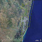
The river flows in an easterly direction to the Indian Ocean
Indian Ocean
The Indian Ocean is the third largest of the world's oceanic divisions, covering approximately 20% of the water on the Earth's surface. It is bounded on the north by the Indian Subcontinent and Arabian Peninsula ; on the west by eastern Africa; on the east by Indochina, the Sunda Islands, and...
at Maphelana, a coastal resort just south of the St Lucia River mouth. It originally meandered over the Monzi Flats, where it split into numerous slow-flowing channels before entering the St. Lucia Estuary
Estuary
An estuary is a partly enclosed coastal body of water with one or more rivers or streams flowing into it, and with a free connection to the open sea....
at Honeymoon Bend. The slow-moving water and reed beds in channels operated as a natural filtering system that removed silt from the Umfolozi floodwaters and created a rich habitat for numerous species.
During the 1950s, the Umfolozi Landowners Association contained and artificially channeled the river through the Monzi Flats to develop sugarcane
Sugarcane
Sugarcane refers to any of six to 37 species of tall perennial grasses of the genus Saccharum . Native to the warm temperate to tropical regions of South Asia, they have stout, jointed, fibrous stalks that are rich in sugar, and measure two to six metres tall...
farms. The new Umfolozi canal resulted in the unfiltered water depositing its silt load after entering the slower moving St. Lucia Estuary. This caused the estuary
Estuary
An estuary is a partly enclosed coastal body of water with one or more rivers or streams flowing into it, and with a free connection to the open sea....
mouth to rapidly silt up. There had only been one record of this occurring until that time, during the sustained drought during the 1930s.
At 28°20′58"S 31°58′46"E the Black Umfolozi River and the White Umfolozi River
White Umfolozi River
The White Umfolozi River originates just south of Vryheid, KwaZulu-Natal, South Africa and joins the Black Umfolozi River at to form the Umfolozi River, before it flows east towards the Indian Ocean.- See also :* List of rivers of South Africa...
, join to form the Umfolozi.
Estuary
An estuary is a partly enclosed coastal body of water with one or more rivers or streams flowing into it, and with a free connection to the open sea....
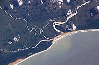
mouth area, but it proved ineffective. After years of dredging, the next plan was to prevent the Umfolozi River from entering the St Lucia estuary. The Umfolozi River was canal
Canal
Canals are man-made channels for water. There are two types of canal:#Waterways: navigable transportation canals used for carrying ships and boats shipping goods and conveying people, further subdivided into two kinds:...
ized straight out to sea at Maphelana. The impact of this decision continues; the silt plume from the river is often blown by strong south winds as far north as Sodwana Bay
Sodwana Bay
Sodwana Bay is located on the east coast of South Africa, between St. Lucia and Lake Sibhayi.Sodwana Bay National Park is a narrow strip of forested sand dunes located along the KwaZulu Natal coast...
, 100 km away. The changes threaten the coral reef
Coral reef
Coral reefs are underwater structures made from calcium carbonate secreted by corals. Coral reefs are colonies of tiny living animals found in marine waters that contain few nutrients. Most coral reefs are built from stony corals, which in turn consist of polyps that cluster in groups. The polyps...
s, which provide fish habitat and protect the shore. In addition, it jeopardizes the associated good snorkeling available at Cape Vidal, part of iSimangaliso Wetland Park, a UNESCO
UNESCO
The United Nations Educational, Scientific and Cultural Organization is a specialized agency of the United Nations...
World Heritage Site
World Heritage Site
A UNESCO World Heritage Site is a place that is listed by the UNESCO as of special cultural or physical significance...
.
External links
See also
- List of rivers of South Africa
- List of reservoirs and dams in South Africa
- List of Water Drainage Area's of South Africa
- Water Management AreasWater Management AreasWater Management Areas are parts of South Africa that are managed by the Water Boards.The list should be complete, and in accordance with the definitions of the Department of Water Affairs...