

U.S. Route 60 in Arizona
Encyclopedia
U.S. Route 60
U.S. Route 60 is an east–west United States highway, running from the Atlantic Ocean on the east coast in Virginia to western Arizona. Despite the final "0" in its number, indicating a transcontinental designation, the 1926 route formerly ended in Springfield, Missouri, at its intersection...
is an east–west United States highway within Arizona
Arizona
Arizona ; is a state located in the southwestern region of the United States. It is also part of the western United States and the mountain west. The capital and largest city is Phoenix...
. The highway runs for 369 miles (593.8 km) from a junction with Interstate 10
Interstate 10 in Arizona
In the U.S. state of Arizona, Interstate 10, the major east–west Interstate Highway in the southern United States, runs east from California, enters Arizona and continues through Phoenix and Tucson and exits at the border with New Mexico.-Route description:...
near Quartzsite to the New Mexico
New Mexico
New Mexico is a state located in the southwest and western regions of the United States. New Mexico is also usually considered one of the Mountain States. With a population density of 16 per square mile, New Mexico is the sixth-most sparsely inhabited U.S...
State Line near Springerville. As it crosses the state, US 60 overlaps at various points: I-17, I-10, SR 77, SR 260, US 191, and US 180.
Route description
The western terminus of US 60 is located at an interchange with I-10 east of Quartzite. It heads northeast from this junction to Vicksburg Junction where it curves towards the east. It continues to the east to HopeHope, Arizona
Hope is a small unincorporated community in the deserts of La Paz County, Arizona, United States. Its name was inspired by the community's hope for increased business after merchants visited the town. Today, it consists of one RV park, one gas station, one church, and one antique store....
where it intersects SR 72. East of Hope, the highway briefly curves towards the north-northeast before curving towards the northeast. It continues this heading until it reaches Aguila
Aguila, Arizona
Aguila is a CDP in Maricopa County, Arizona, United States. It is located on U.S. Route 60 approximately 20 miles west of Wickenburg, or at approximately 50000 N. 510th Ave. Major economic activities include cantaloupe farming and formerly included mining. It uses the same street numbering system...
. The highway heads east to an intersection with SR 71 after passing through Aguila. US 60 continues towards the east until it reaches Wickenburg
Wickenburg, Arizona
Wickenburg is a town in Maricopa County, Arizona, United States. According to 2006 Census Bureau estimates, the population of the town is 6,423.-Geography:Wickenburg is located at ....
and an intersection with US 93
U.S. Route 93 in Arizona
In the U.S. state of Arizona, U.S. Route 93 is a U.S. Highway that begins in Wickenburg and heads north to the Nevada border at the Mike O'Callaghan – Pat Tillman Memorial Bridge....
. From Wickenburg, the highway heads towards the southeast towards Phoenix
Phoenix, Arizona
Phoenix is the capital, and largest city, of the U.S. state of Arizona, as well as the sixth most populated city in the United States. Phoenix is home to 1,445,632 people according to the official 2010 U.S. Census Bureau data...
. It has an intersection with SR 74 in Morristown
Morristown, Arizona
Morristown is a census-designated place in Maricopa County, Arizona, United States. It is located about 50 miles northwest of Phoenix, at the junction of State Route 74 and U.S...
as it continues towards the southeast.
Phoenix area
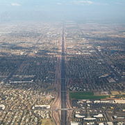
As US 60 enters the Phoenix metropolitan area
Phoenix Metropolitan Area
The Phoenix metropolitan area, often referred to as The Valley of the Sun, is a metropolitan area, centered on the city of Phoenix, that includes much of the central part of the US state of Arizona...
, it carries the name Grand Avenue and cuts a diagonal path through the northwestern part of the metropolitan area. It intersects Loop 303 in Surprise
Surprise, Arizona
Surprise is a city in Maricopa County, Arizona, USA. The population was 30,848 at the 2000 census; however, rapid growth has boosted the city's population to 117,517 at the 2010 census, an increase of 281%...
as it continues to the southeast. It continues to a junction with Loop 101 in Peoria
Peoria, Arizona
Peoria is a city in Maricopa and Yavapai counties in the U.S. state of Arizona. Located primarily in Maricopa County, it is a major suburb of Phoenix. According to 2010 Census Bureau releases, the population of the city is 154,065. Peoria is currently the sixth largest city in Arizona for land...
before heading through Glendale
Glendale, Arizona
Glendale is a city in Maricopa County, Arizona, USA, located about nine miles northwest from Downtown Phoenix. According to 2010 Census Bureau, the population of the city is 226,721....
. The highway enters the Phoenix city limits and continues towards the southeast until it reaches Thomas Road. US 60 follows Thomas Road for 1/4 mile until it reaches I-17. At I-17 the highway begins to run concurrently with I-17 towards the south. It passes I-10 interchange known as The Stack
The Stack
The Stack is a colloquialism used to describe the symmetrical, four-level stack interchange in Downtown Phoenix in the U.S. state of Arizona that facilitates movements between Interstate 17/U.S...
. US 60 continues to run concurrent with I-17 around the Durango Curve and continues east until it reaches the I-10 interchange known as The Split. US 60 begins to run concurrently towards the east with I-10 after the interchange. I-10 and US 60 continue towards the southeast after the interchange. The freeway passes along the south side of the airport
Phoenix Sky Harbor International Airport
Phoenix Sky Harbor International Airport is a joint civil-military public airport located southeast of the central business district of the city of Phoenix, in Maricopa County, Arizona, United States...
and passes over a bridge over the Salt River
Salt River (Arizona)
The Salt River is a stream in the U.S. state of Arizona. It is the largest tributary of the Gila River. The river is about long. Its drainage basin is about large. The longest of the Salt River's many tributaries is the Verde River...
. Once over the river, the freeway continues towards the east through Tempe
Tempe, Arizona
Tempe is a city in Maricopa County, Arizona, USA, with the Census Bureau reporting a 2010 population of 161,719. The city is named after the Vale of Tempe in Greece. Tempe is located in the East Valley section of metropolitan Phoenix; it is bordered by Phoenix and Guadalupe on the west, Scottsdale...
to an interchange with SR 143. The freeway curves back towards the south following the SR 143 interchange.
Superstition Freeway
After the curve, I-10 and US 60 part ways with I-10 continuing towards the south and US 60 now heading east along the Superstition Freeway. The freeway continues towards the east to a second interchange with Loop 101. The freeway enters the Mesa
Mesa, Arizona
According to the 2010 Census, the racial composition of Mesa was as follows:* White: 77.1% * Hispanic or Latino : 26.54%* Black or African American: 3.5%* Two or more races: 3.4%* Native American: 2.4%...
city limits after the interchange as it continues towards the east to the SuperRedTan
SuperRedTan Interchange
The SuperRedTan Interchange is a symmetrical four-level freeway interchange in eastern Mesa, Arizona. Completed in 2007, the interchange provides access between U.S. Route 60 and Loop 202. It is fully directional, meaning that a motorist traveling towards the interchange in any direction can exit...
interchange with Loop 202. The freeway enters the city limits of Apache Junction
Apache Junction, Arizona
Apache Junction is a city in Maricopa and Pinal counties in the U.S. state of Arizona. According to the 2010 Census, the population of the city was 35,840, most of whom lived in Pinal County....
in Pinal County
Pinal County, Arizona
-2010:Whereas according to the 2010 U.S. Census Bureau:*72.4% White*4.6% Black*5.6% Native American*1.7% Asian*0.4% Native Hawaiian or Pacific Islander*3.8% Two or more races*11.5% Other races*28.5% Hispanic or Latino -2000:...
as it continues eastbound. The freeway portion of the highway ends in Apache Junction as US 60 curves towards the southeast.
The highway continues towards the southeast passing through Gold Canyon
Gold Canyon, Arizona
Gold Canyon is a census-designated place in Pinal County, Arizona, United States. The population was 6,029 at the 2000 census. The community is sometimes incorrectly called Gold Camp....
to an interchange with SR 79 at Florence Junction. US 60 curves towards the east at this junction as it heads to Superior and an intersection with SR 177
Arizona State Route 177
State Route 177 or SR 177 runs in a north–south direction from Superior, Arizona to Winkelman, Arizona.It ends at two junctions, US 60 to the north and State Route 77 to the south. The southern half of this road runs alongside the Gila River and the Copper Basin Railroad.The road passes...
. From Superior the highway begins to head towards the northeast to Miami
Miami, Arizona
Miami is a town in Gila County, Arizona, United States. Miami is a classic Western copper boomtown, though the copper mines are largely dormant now...
and Claypool
Claypool, Arizona
Claypool is a census-designated place in Gila County, Arizona, United States. The population was 1,794 at the 2000 census.-Geography:Claypool is located at ....
. It continues to a junction with SR 188
Arizona State Route 188
State Route 188 is state highway located in Gila County in the U.S. state of Arizona.-Route description:The route starts at U.S. Route 60 in Claypool, just west of Globe, and runs generally northwest to a junction with State Route 288, then continues alongside Lake Roosevelt. The route junctions...
before passing through Midland City and turning towards the south towards Globe
Globe, Arizona
Globe has an arid climate, characterized by hot summers and moderate to warm winters. Globe's arid climate is somewhat tempered by its elevation, however, leading to slightly cooler temperatures and slightly more precipitation than Phoenix or Yuma....
. US 60 curves back towards the east in Globe and continues to an intersection with US 70 and SR 77. US 60 heads northeast from the intersection concurrent with SR 77. The two highways curve towards the north before curving back towards the northeast as they head towards Show Low
Show Low, Arizona
Winters in Show Low bring highs between 45°F and 55°F , with lows usually below freezing between November and March, averaging in the 20s December through February, and in the low 30s for November and March....
. As the highway continues towards the northeast it enters the San Carlos Indian Reservation. Within the reservation, the highway goes through a series of hairpin turn
Hairpin turn
A hairpin turn , named for its resemblance to a hairpin/bobby pin, is a bend in a road with a very acute inner angle, making it necessary for an oncoming vehicle to turn almost 180° to continue on the road. Such turns in ramps and trails may be called switchbacks in American English, by analogy...
s as it enters the Salt River Canyon. After descending into the canyon, the highway passes over the Salt River and enters the Fort Apache Indian Reservation
Fort Apache Indian Reservation
The Fort Apache Indian Reservation is an Indian reservation in Arizona, United States, encompassing parts of Navajo, Gila, and Apache counties. It is home to the federally recognized White Mountain Apache Tribe of the Fort Apache Reservation, a Western Apache tribe. It has a land area of 2,627.608...
. The highway continues towards the northeast and enters Navajo County
Navajo County, Arizona
-2010:Whereas according to the 2010 U.S. Census Bureau:*49.3% White*0.9% Black*43.4% Native American*0.5% Asian*0.1% Native Hawaiian or Pacific Islander*2.5% Two or more races*3.3% Other races*10.8% Hispanic or Latino -2000:...
before reaching an intersection with SR 73. It continues northeast from this intersection to the city of Show Low.
In Show Low, US 60 intersects SR 260 and briefly runs concurrently with SR 260 as it heads northeast through the city. The concurrency with SR 77 also ends in Show Low as SR 77 heads north to Snowflake
Snowflake, Arizona
Snowflake is a town in Navajo County, Arizona, United States. It was founded in 1878 by Erastus Snow and William Jordan Flake, Mormon pioneers and colonizers. According to 2006 Census Bureau estimates, the population of the town is 4,958....
and US 60 continues towards the east. US 60 leaves the Show Low city limits and heads east to a junction with SR 61 which heads northeast towards Concho
Concho, Arizona
Concho is an unincorporated community in Apache County, Arizona, United States. Concho is located on Arizona State Route 61 west of St. Johns. Concho has the ZIP code 85924....
. US 60 continues east from this intersection before curving towards the southeast as it heads towards Springerville
Springerville, Arizona
Springerville is a town in Apache County, Arizona, United States within the White Mountains. Its postal ZIP code is 85938. According to 2006 Census Bureau estimates, the population of the town is 1,956.Springerville sits at an elevation of 6,974 feet...
.
As it enters the Springerville city limits, it intersects and begins to run concurrently with US 180 and US 191. The three highways continue along the same alignment through Springerville, passing over the Little Colorado River
Little Colorado River
The Little Colorado River is a river in the U.S. state of Arizona, providing the principal drainage from the Painted Desert region. Together with its major tributary, the Puerco River, it drains an area of about in eastern Arizona and western New Mexico...
. As the three highways continue through the city, they eventually split with US 180 and US 191 heading south towards Alpine
Alpine, Arizona
Alpine is an unincorporated community in Apache County, Arizona, United States, in Bush Valley in the east central part of the state. Alpine was settled in 1876 by Anderson Bush who built a log house originally known as "Fort Bush". Bush sold his holdings in 1879 to William Maxwell and Fred...
and US 60 continuing towards the east. US 60 continues towards the east leaving the Springerville city limits and crossing over the state line into New Mexico
New Mexico
New Mexico is a state located in the southwest and western regions of the United States. New Mexico is also usually considered one of the Mountain States. With a population density of 16 per square mile, New Mexico is the sixth-most sparsely inhabited U.S...
.
History
US 60 was extended into Arizona in 1932, from its original western terminus at US 66 in Springfield, MO. US 60 through Arizona has had far fewer major changes than some other U.S. routes, but one notable example is being replaced by Interstate 10Interstate 10 in Arizona
In the U.S. state of Arizona, Interstate 10, the major east–west Interstate Highway in the southern United States, runs east from California, enters Arizona and continues through Phoenix and Tucson and exits at the border with New Mexico.-Route description:...
between Los Angeles, CA and the highway's current terminus near Quartzsite
Quartzsite, Arizona
Quartzsite is a town in La Paz County, Arizona, United States. According to Census Bureau estimates, the population of the town was 3,397 in 2006.Interstate 10 runs directly through Quartzsite. It is at the intersection of U.S...
. US 60 is now the only US Route to serve Phoenix. US 70 (decom. 1969), US 80 (decom. 1977) & US 89 (decom. 1992) have all been truncated outside of Phoenix. The only other major change was being realigned from an "In-Town" route along city arterials through Mesa, Tempe, and Phoenix to the old SR 360 alignment a few miles south and merging with I-10
Interstate 10 in Arizona
In the U.S. state of Arizona, Interstate 10, the major east–west Interstate Highway in the southern United States, runs east from California, enters Arizona and continues through Phoenix and Tucson and exits at the border with New Mexico.-Route description:...
and I-17 into Downtown Phoenix
Downtown Phoenix
Downtown Phoenix is the central business district of Phoenix, Arizona, United States. It is located near the geographic center of the Phoenix metropolitan area or Valley of the Sun. Phoenix, being the county seat of Maricopa County and the capital of Arizona, serves as the center of politics,...
.
In 1949, the Pinto Creek Bridge won an Annual Award of Merit for being the "most beautiful steel bridge", given by the American Institute of Steel Construction.
In 1952, the Claypool Tunnel was bypassed by the Queen Creek Tunnel, upgrading from a simple 'hole in the rock' type tunnel to a more modern tunnel.
In recent years, Arizona Department of Transportation (ADOT)
Arizona Department of Transportation
The Arizona Department of Transportation is an Arizona state government agency charged with facilitating mobility within the state. In addition to managing the state's highway system, the agency is also involved with public transportation and municipal airports...
has been working to widen and improve US 60 through the Metropolitan Phoenix Area, as it is one of the area's principal freeways. Along the Superstition Freeway segment in the East Valley between I-10
Interstate 10 in Arizona
In the U.S. state of Arizona, Interstate 10, the major east–west Interstate Highway in the southern United States, runs east from California, enters Arizona and continues through Phoenix and Tucson and exits at the border with New Mexico.-Route description:...
and Loop 202
Arizona State Route 202
State Route 202, or Loop 202, is the beltway encompassing the eastern Phoenix, Arizona, United States Metropolitan area. It navigates and surrounds the cities of Tempe, Mesa, Chandler, and Gilbert, making it very vital to the area freeway system...
, ADOT has completed its project of adding additional general purpose lanes (6 total plus an HOV in each direction), adding auxiliary lanes between exits, improving sound barriers, replacing signs, improving lighting conditions, adding rubberized asphalt
Rubberized asphalt
Rubberized asphalt concrete , also known as asphalt rubber or just rubberized asphalt, is pavement material that consists of regular asphalt concrete mixed with crumb rubber–ground, used tires that might otherwise be discarded, taking up space in landfills, if they were not re-directed for use as...
to reduce noise, adding variable message signs, installing cameras, and adding traffic sensors.
Along the Grand Avenue segment in Phoenix, ADOT has been widening portions of Grand Avenue in addition to constructing additional overpasses and underpasses at six former six-way intersections to improve traffic flow along US 60 in the Northwest Valley.
ADOT is currently in the study phase of adding additional lanes between Loop 101 and Loop 303 in the far West Valley.
The portion of old US 60 in Mesa between Sossaman Road and Meridian Drive is known as unsigned U.S. Route 60x by ADOT.
Junction list
Only the Superstition Freeway section of US 60 has exit numbers. All other segments are standard divided or undivided highways with uncontrolled access. The mileposts were not renumbered after the western leg was truncated, so they begin at 31.| County | Location | Mile | # Exit number An exit number is a number assigned to a road junction, usually an exit from a freeway. It is usually marked on the same sign as the destinations of the exit, as well as a sign in the gore.... |
Destination | Notes |
|---|---|---|---|---|---|
| La Paz La Paz County, Arizona La Paz County is a county in the western part of the U.S. state of Arizona. As of the 2010 census its population was 20,489. The county seat is Parker... |
30.89 | , Los Angeles Los Angeles, California Los Angeles , with a population at the 2010 United States Census of 3,792,621, is the most populous city in California, USA and the second most populous in the United States, after New York City. It has an area of , and is located in Southern California... |
|||
| 49.55 | |||||
| Maricopa Maricopa County, Arizona -2010:Whereas according to the 2010 U.S. Census Bureau:*73.0% White*5.0% Black*2.1% Native American*3.5% Asian*0.2% Native Hawaiian or Pacific Islander*3.5% Two or more races*12.7% Other races*29.6% Hispanic or Latino -2000:... |
86.07 | ||||
| Wickenburg Wickenburg, Arizona Wickenburg is a town in Maricopa County, Arizona, United States. According to 2006 Census Bureau estimates, the population of the town is 6,423.-Geography:Wickenburg is located at .... |
110.33 | ||||
| Morristown Morristown, Arizona Morristown is a census-designated place in Maricopa County, Arizona, United States. It is located about 50 miles northwest of Phoenix, at the junction of State Route 74 and U.S... |
120.11 | ||||
| Wittmann, Arizona Wittmann, Arizona Wittmann is a census-designated place in Maricopa County, Arizona, United States. It is located along U.S. Route 60 in the central part of Arizona, about 35 miles northwest of central Phoenix, and while technically located within the city's metropolitan area it is generally regarded by locals to... |
163rd Avenue | ||||
| Sun City West Sun City West, Arizona Sun City West is a census-designated place in Maricopa County, Arizona, United States. The population was 26,344 at the 2000 census.-Geography:Sun City West is located at .... |
Interchange | ||||
| Sunrise Boulevard/R. H. Johnson Bolevard | |||||
| Reems Road, Meeker Road | |||||
| Parkview Place | |||||
| Surprise Surprise, Arizona Surprise is a city in Maricopa County, Arizona, USA. The population was 30,848 at the 2000 census; however, rapid growth has boosted the city's population to 117,517 at the 2010 census, an increase of 281%... |
Bell Road Bell Road (Phoenix Metro) Bell Road is a major east-west arterial road in northern metropolitan Phoenix, Arizona, United States. Bell Road is one of the few roadways to cross the Agua Fria River in the northern part of the metro area, providing a vital link between the growing suburb of Surprise with Phoenix... |
||||
| Dysart Road | |||||
| Greenway Road | |||||
| El Mirage El Mirage, Arizona El Mirage is a city in Maricopa County, Arizona, United States. According to Census 2010, the population of the city is 31,767.-Geography:El Mirage is located at .... |
Thompson Ranch Road | ||||
| Sun City, Youngtown Youngtown, Arizona Youngtown is a town in Maricopa County, Arizona, United States. According to 2008 Census Bureau and Arizona Department of Commerce estimates, the population of the town is 6,522.Youngtown is the nation's oldest retirement community... |
111th Avenue | ||||
| Sun City | 107th Avenue | ||||
| 103rd Avenue | |||||
| 99th Avenue | |||||
| Peoria | 148.90 | Interchange | |||
| 149.23 | |||||
| 85th Avenue | |||||
| Peoria Avenue | |||||
| 150.60 | 83rd Avenue | ||||
| 151.97 | Olive Avenue, 75th Avenue | Interchange | |||
| Glendale | 153.35 | Northern Avenue, 67th Avenue | Interchange | ||
| 154.40 | Myrtle Avenue to Glendale Avenue, 59th Avenue | ||||
| 154.99 | 57th Drive | ||||
| 155.41 | Maryland Avenue, 55th Avenue | Interchange; westbound exit and entrance | |||
| 156.21 | Bethany Home Road, 51st Avenue | Interchange | |||
| 157.59 | 157 | 43rd Avenue, Camelback Road | Interchange | ||
| Phoenix | |||||
| 159.01 | Indian School Road, 35th Avenue | Interchange | |||
| 159.36 | 33rd Avenue | ||||
| 159.70 | Osborn Road, 31st Avenue | ||||
| 159.86 | Osborn Avenue | ||||
Begin .svg.png) / /  concurrency concurrencyConcurrency (road) A concurrency, overlap, or coincidence in a road network is an instance of one physical road bearing two or more different highway, motorway, or other route numbers... Exit numbers use I-17 exit numbers |
|||||
| 201 | Westbound exit only | ||||
| 200A-B | The Stack The Stack The Stack is a colloquialism used to describe the symmetrical, four-level stack interchange in Downtown Phoenix in the U.S. state of Arizona that facilitates movements between Interstate 17/U.S... |
||||
| 199B | Adams Street (Northbound) / Jefferson Street (Southbound) | ||||
| 199A | MC 85 - Buckeye Road | ||||
| 198 | Buckeye Road | ||||
| 197 | 19th Avenue, Durango Street | Durango Curve | |||
| 196 | 7th Ave, Central Avenue | Eastbound exit only | |||
| 195B | 7th Street, Central Avenue | Westbound exit only | |||
| 195A | 16th Street | Eastbound exit only | |||
| 194 | Eastbound exit only | ||||
| End / concurrency Concurrency (road) A concurrency, overlap, or coincidence in a road network is an instance of one physical road bearing two or more different highway, motorway, or other route numbers... Begin .svg.png) / concurrency / concurrencyExit numbers use I-10 exit numbers |
|||||
| 150A | Westbound exit only | ||||
| 150B | 24th Street | Westbound exit only | |||
| 151 | University Drive, 32nd Street – University of Phoenix Online University of Phoenix The University of Phoenix is a for-profit institution of higher learning. It is a wholly owned subsidiary of Apollo Group Inc. which is publicly traded , an S&P 500 corporation based in Phoenix, Arizona... , Apollo Group Apollo Group Apollo Group, Inc. is an S&P 500 corporation based in the South Phoenix area of Phoenix, Arizona. Apollo Group, Inc., through its subsidiaries, owns several for-profit educational institutions.... |
||||
| 152 | 40th Street – University of Phoenix at Hohokam University of Phoenix The University of Phoenix is a for-profit institution of higher learning. It is a wholly owned subsidiary of Apollo Group Inc. which is publicly traded , an S&P 500 corporation based in Phoenix, Arizona... , Rio Salado Community College Rio Salado Community College Rio Salado College, known as "the college within everyone's reach," is the largest of the 10 Maricopa Community Colleges and has never built a traditional campus... |
||||
| Tempe Tempe, Arizona Tempe is a city in Maricopa County, Arizona, USA, with the Census Bureau reporting a 2010 population of 161,719. The city is named after the Vale of Tempe in Greece. Tempe is located in the East Valley section of metropolitan Phoenix; it is bordered by Phoenix and Guadalupe on the west, Scottsdale... |
153A | Eastbound exit only | |||
| 154 | Eastbound exit only | ||||
| End / concurrency Concurrency (road) A concurrency, overlap, or coincidence in a road network is an instance of one physical road bearing two or more different highway, motorway, or other route numbers... |
|||||
| 171 | Westbound exit only; signed as 171A (south) & 171B (north) | ||||
| 172 | Priest Drive – Arizona Mills Arizona Mills Arizona Mills is an indoor outlet mall in Tempe, Arizona. It is mostly owned by Simon Property Group and managed by The Taubman Company. It opened on November 20, 1997, with 6,000 parking spaces and approximately 200 retailers. It is currently anchored by outlet versions of Saks Fifth Avenue,... Mall |
Westbound exit only | |||
| 173 | Mill Avenue – Arizona State University Arizona State University Arizona State University is a public research university located in the Phoenix Metropolitan Area of the State of Arizona... , Downtown Tempe |
||||
| 174 | Rural Road | ||||
| 175 | McClintock Drive | ||||
| 176 | – Price Freeway | ||||
| Mesa Mesa, Arizona According to the 2010 Census, the racial composition of Mesa was as follows:* White: 77.1% * Hispanic or Latino : 26.54%* Black or African American: 3.5%* Two or more races: 3.4%* Native American: 2.4%... |
177 | Dobson Road – Mesa Community College Mesa Community College Mesa Community College in Mesa, Arizona, is the largest of the 10 community colleges in the Maricopa County Community College District and is the largest in the United States. MCC began in 1963 as a branch of Phoenix College and later granted independent status in 1965.MCC offers more than 200... |
|||
| 178 | Alma School Road | ||||
| 179 | |||||
| 180 | Mesa Drive | ||||
| 181 | Stapley Drive | ||||
| 182 | Gilbert Road – Gilbert Gilbert, Arizona -Demographics:As of July 1, 2009, Maricopa Association of Governments, Census 2000. United States Census Bureau. there were 217,521 people, 74,147 housing units, and 3.01 persons per household.... |
||||
| 184 | Val Vista Drive | ||||
| 185 | Greenfield Road – Mesa Falcon Field | ||||
| 186 | Higley Road | ||||
| 187 | Superstition Springs Boulevard | Eastbound exit only | |||
| 188 | Power Road – Phoenix-Mesa Gateway Airport Phoenix-Mesa Gateway Airport Phoenix-Mesa Gateway Airport , formerly Williams Gateway Airport and Williams Air Force Base , is a commercial airport located in the southeastern area of the city of Mesa, Arizona, and southeast of Phoenix, in Maricopa County, Arizona, United States. The airport is owned and operated by the... , ASU Polytechnic |
||||
| 189 | Sossaman Road | Eastbound exit only | |||
| 190 | – Red Mountain Freeway, Santan Freeway | SuperRedTan SuperRedTan Interchange The SuperRedTan Interchange is a symmetrical four-level freeway interchange in eastern Mesa, Arizona. Completed in 2007, the interchange provides access between U.S. Route 60 and Loop 202. It is fully directional, meaning that a motorist traveling towards the interchange in any direction can exit... |
|||
| 191 | Ellsworth Road | ||||
| 192 | Crismon Road | ||||
| 193 | Signal Butte Road | ||||
| Pinal Pinal County, Arizona -2010:Whereas according to the 2010 U.S. Census Bureau:*72.4% White*4.6% Black*5.6% Native American*1.7% Asian*0.4% Native Hawaiian or Pacific Islander*3.8% Two or more races*11.5% Other races*28.5% Hispanic or Latino -2000:... |
Apache Junction Apache Junction, Arizona Apache Junction is a city in Maricopa and Pinal counties in the U.S. state of Arizona. According to the 2010 Census, the population of the city was 35,840, most of whom lived in Pinal County.... |
195 | Ironwood Drive | ||
| 196 | – Salt River Salt River (Arizona) The Salt River is a stream in the U.S. state of Arizona. It is the largest tributary of the Gila River. The river is about long. Its drainage basin is about large. The longest of the Salt River's many tributaries is the Verde River... Lakes, Roosevelt Dam, and Apache Trail Apache Trail The Apache Trail in Arizona was a stagecoach trail that ran through the Superstition Mountains. It was named the Apache Trail after the Apache Indians who originally used this trail to move through the Superstition Mountains.... Highway |
||||
| 197 | Tomahawk Road | ||||
| 198 | Goldfield Road | ||||
| 199 | E. Old West Road | Westbound exit only | |||
| 200 | Mountain View Road | Traffic Light | |||
| Gold Canyon Gold Canyon, Arizona Gold Canyon is a census-designated place in Pinal County, Arizona, United States. The population was 6,029 at the 2000 census. The community is sometimes incorrectly called Gold Camp.... |
201 | Superstition Mountain Drive | Traffic Light | ||
| 202 | Mountainbrook Drive | Traffic Light | |||
| 203 | Kings Ranch Road | Traffic Light | |||
| 204 | Peralta Road | 3-way Stop Sign Stop Sign "Stop Sign" is the third single released from former Five member Abs Breen's debut solo album, Abstract Theory. The single found fair success, peaking at #10 in the UK and #53 in Australia... |
|||
| 205 | Renaissance Festival Road | Traffic Light (Only Used Seasonaly) | |||
| 209 | El Camino Viejo | ||||
| Florence Junction | 212 | ||||
| Superior | 227 | ||||
| Gila Gila County, Arizona -2010:Whereas according to the 2010 U.S. Census Bureau:*76.8% White*0.4% Black*14.8% Native American*0.5% Asian*0.1% Native Hawaiian or Pacific Islander*2.0% Two or more races*5.4% Other races*17.9% Hispanic or Latino -2000:... |
Central Heights | 247 | , Theodore Roosevelt Dam Theodore Roosevelt Dam Theodore Roosevelt Dam is a dam on the Salt River located northeast of Phoenix, Arizona. The dam is high and forms Theodore Roosevelt Lake as it impounds the Salt River. Originally built between 1905 and 1911, the dam was renovated and expanded in 1989-1996. The dam is named after then-President... |
||
| Globe Globe, Arizona Globe has an arid climate, characterized by hot summers and moderate to warm winters. Globe's arid climate is somewhat tempered by its elevation, however, leading to slightly cooler temperatures and slightly more precipitation than Phoenix or Yuma.... |
252 | Northerly Cardinal Direction from 3-way intersection - Entrance to Salt River Canyon | |||
Begin /  concurrency concurrencyConcurrency (road) A concurrency, overlap, or coincidence in a road network is an instance of one physical road bearing two or more different highway, motorway, or other route numbers... |
|||||
| Navajo Navajo County, Arizona -2010:Whereas according to the 2010 U.S. Census Bureau:*49.3% White*0.9% Black*43.4% Native American*0.5% Asian*0.1% Native Hawaiian or Pacific Islander*2.5% Two or more races*3.3% Other races*10.8% Hispanic or Latino -2000:... |
Show Low Show Low, Arizona Winters in Show Low bring highs between 45°F and 55°F , with lows usually below freezing between November and March, averaging in the 20s December through February, and in the low 30s for November and March.... |
340 | Temporary Concurancy with US 60/SR 77/SR 260 through Show Low along Deuce of Clubs Avenue | ||
| 341 | |||||
| 342 | |||||
| End / concurrency Concurrency (road) A concurrency, overlap, or coincidence in a road network is an instance of one physical road bearing two or more different highway, motorway, or other route numbers... |
|||||
| Apache Apache County, Arizona -2010:Whereas according to the 2010 U.S. Census Bureau:*23.3% White*0.2% Black*72.9% Native American*0.3% Asian*0.0% Native Hawaiian or Pacific Islander*2.0% Two or more races*1.3% Other races*5.8% Hispanic or Latino -2000:... |
Bell | 343 | |||
| 384 | |||||
Begin /  / /  concurrency concurrencyConcurrency (road) A concurrency, overlap, or coincidence in a road network is an instance of one physical road bearing two or more different highway, motorway, or other route numbers... |
|||||
| Springerville Springerville, Arizona Springerville is a town in Apache County, Arizona, United States within the White Mountains. Its postal ZIP code is 85938. According to 2006 Census Bureau estimates, the population of the town is 1,956.Springerville sits at an elevation of 6,974 feet... |
388 | ||||
| 389 | |||||
| End / / concurrency Concurrency (road) A concurrency, overlap, or coincidence in a road network is an instance of one physical road bearing two or more different highway, motorway, or other route numbers... |
|||||
| continues into New Mexico |
|||||
See also
- SuperRedTan InterchangeSuperRedTan InterchangeThe SuperRedTan Interchange is a symmetrical four-level freeway interchange in eastern Mesa, Arizona. Completed in 2007, the interchange provides access between U.S. Route 60 and Loop 202. It is fully directional, meaning that a motorist traveling towards the interchange in any direction can exit...
- Superstition MountainsSuperstition MountainsThe Superstition Mountains , popularly referred to as "The Superstitions", are a range of mountains in Arizona located to the east of the Phoenix metropolitan area...
- Metropolitan Phoenix freeways