
SuperRedTan Interchange
Encyclopedia
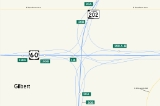
The SuperRedTan Interchange is a symmetrical four-level freeway interchange
in eastern Mesa
, Arizona
. Completed in 2007, the interchange provides access between U.S. Route 60
and Loop 202
. It is fully directional, meaning that a motorist traveling towards the interchange in any direction can exit onto either direction of the intersecting freeway. The interchange is said to be the first in the Valley of the Sun
to include design icons on the support columns in addition to the retaining walls. There are no HOV connections at this time, although they are planned in the future.
s. There was 60511 feet (18,443.8 m) of mechanically stabilized earth walls with some segments reaching up to 53 feet (16.2 m) tall. 162040 feet (49,389.8 m) of soundwalls were also built within the project area to minimize the amount of decibel
s that the interchange was projected to generate the surrounding communities. The SuperRedTan Interchange project also consisted of widening the Superstition Freeway between Power and Crismon Roads, and constructing Loop 202
from scratch from the interchange
north to University Drive. Phased construction
lasted four years, from 2003 to 2007, and cost $116 million USD
. It was funded through Proposition 300, which was passed in 1985 by Maricopa County voters.
Stack interchange
A stack interchange is a free-flowing grade separated junction between two roads.In countries where one drives on the right, left turns are handled by semi-directional flyover/under ramps...
in eastern Mesa
Mesa, Arizona
According to the 2010 Census, the racial composition of Mesa was as follows:* White: 77.1% * Hispanic or Latino : 26.54%* Black or African American: 3.5%* Two or more races: 3.4%* Native American: 2.4%...
, Arizona
Arizona
Arizona ; is a state located in the southwestern region of the United States. It is also part of the western United States and the mountain west. The capital and largest city is Phoenix...
. Completed in 2007, the interchange provides access between U.S. Route 60
U.S. Route 60 in Arizona
U.S. Route 60 is an east–west United States highway within Arizona. The highway runs for from a junction with Interstate 10 near Quartzsite to the New Mexico State Line near Springerville...
and Loop 202
Arizona State Route 202
State Route 202, or Loop 202, is the beltway encompassing the eastern Phoenix, Arizona, United States Metropolitan area. It navigates and surrounds the cities of Tempe, Mesa, Chandler, and Gilbert, making it very vital to the area freeway system...
. It is fully directional, meaning that a motorist traveling towards the interchange in any direction can exit onto either direction of the intersecting freeway. The interchange is said to be the first in the Valley of the Sun
Phoenix Metropolitan Area
The Phoenix metropolitan area, often referred to as The Valley of the Sun, is a metropolitan area, centered on the city of Phoenix, that includes much of the central part of the US state of Arizona...
to include design icons on the support columns in addition to the retaining walls. There are no HOV connections at this time, although they are planned in the future.
Etymology
The name SuperRedTan is a portmanteau of the names of three area freeways that intersect at this point. The name borrows the bolded portions of the following to form the word SuperRedTan.- Superstition FreewayU.S. Route 60 in ArizonaU.S. Route 60 is an east–west United States highway within Arizona. The highway runs for from a junction with Interstate 10 near Quartzsite to the New Mexico State Line near Springerville...
- Red Mountain FreewayArizona State Route 202State Route 202, or Loop 202, is the beltway encompassing the eastern Phoenix, Arizona, United States Metropolitan area. It navigates and surrounds the cities of Tempe, Mesa, Chandler, and Gilbert, making it very vital to the area freeway system...
- Santan FreewayArizona State Route 202State Route 202, or Loop 202, is the beltway encompassing the eastern Phoenix, Arizona, United States Metropolitan area. It navigates and surrounds the cities of Tempe, Mesa, Chandler, and Gilbert, making it very vital to the area freeway system...
Construction
In order to successfully create the SuperRedTan Interchange, twelve bridges were built for a combined bridge deck area of 321000 square feet (29,821.9 m²). All of the bridges were built using cast-in-place concrete, with post-tensioned box girderBox girder
A box or tubular girder is a girder that forms an enclosed tube with multiple walls, rather than an or H-beam. Originally constructed of riveted wrought iron, they are now found in rolled or welded steel, aluminium extrusions or pre-stressed concrete....
s. There was 60511 feet (18,443.8 m) of mechanically stabilized earth walls with some segments reaching up to 53 feet (16.2 m) tall. 162040 feet (49,389.8 m) of soundwalls were also built within the project area to minimize the amount of decibel
Decibel
The decibel is a logarithmic unit that indicates the ratio of a physical quantity relative to a specified or implied reference level. A ratio in decibels is ten times the logarithm to base 10 of the ratio of two power quantities...
s that the interchange was projected to generate the surrounding communities. The SuperRedTan Interchange project also consisted of widening the Superstition Freeway between Power and Crismon Roads, and constructing Loop 202
Arizona State Route 202
State Route 202, or Loop 202, is the beltway encompassing the eastern Phoenix, Arizona, United States Metropolitan area. It navigates and surrounds the cities of Tempe, Mesa, Chandler, and Gilbert, making it very vital to the area freeway system...
from scratch from the interchange
Interchange (road)
In the field of road transport, an interchange is a road junction that typically uses grade separation, and one or more ramps, to permit traffic on at least one highway to pass through the junction without directly crossing any other traffic stream. It differs from a standard intersection, at which...
north to University Drive. Phased construction
Construction
In the fields of architecture and civil engineering, construction is a process that consists of the building or assembling of infrastructure. Far from being a single activity, large scale construction is a feat of human multitasking...
lasted four years, from 2003 to 2007, and cost $116 million USD
United States dollar
The United States dollar , also referred to as the American dollar, is the official currency of the United States of America. It is divided into 100 smaller units called cents or pennies....
. It was funded through Proposition 300, which was passed in 1985 by Maricopa County voters.
See also
- Mini StackMini StackThe Mini Stack is the freeway interchange among Interstate 10, State Route 51, and Loop 202 in Phoenix, Arizona, United States, located northeast of downtown...
- Loop 202Arizona State Route 202State Route 202, or Loop 202, is the beltway encompassing the eastern Phoenix, Arizona, United States Metropolitan area. It navigates and surrounds the cities of Tempe, Mesa, Chandler, and Gilbert, making it very vital to the area freeway system...
- US 60U.S. Route 60 in ArizonaU.S. Route 60 is an east–west United States highway within Arizona. The highway runs for from a junction with Interstate 10 near Quartzsite to the New Mexico State Line near Springerville...