

U.S. Route 421 in Virginia
Encyclopedia
U.S. Route 421 is a part of the U.S. Highway System that runs from Fort Fisher, North Carolina to Michigan City, Indiana
. In Virginia
, the U.S. Highway runs 69.23 miles (111.4 km) from the Tennessee
state line between the twin cities
of Bristol, Tennessee
and Bristol, Virginia
north and west to the Kentucky
state line near St. Charles
. Between its endpoints, US 421 has lengthy concurrencies
with US 23
and US 58
during its course through Bristol, Weber City
, Gate City
, Duffield
, and Pennington Gap
in Southwest Virginia
.
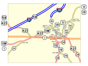
. The U.S. Highway heads north parallel to Norfolk Southern Railway
's Pulaski District and the Bristol Railroad Station along four-lane divided Martin Luther King Jr. Boulevard to Cumberland Street, where US 11 Truck and US 19 Truck continue north along Martin Luther King Jr. Boulevard. US 421 and the two truck routes follow four-lane divided Cumberland Street to Piedmont Avenue; here, the U.S. Highways turn south onto Piedmont while SR 113
turns north from Cumberland onto Piedmont Avenue heading north. US 421, US 11 Truck, and US 19 Truck follow two-lane Piedmont Avenue one block to Goode Street, which the highways follow through the Bristol Commercial Historic District
to Commonwealth Avenue, which carries US 11E
, US 19
, and SR 381
and where the truck routes reach their southern termini.
US 421, US 11E, US 19, and SR 381 meet the southern end of SR 113 at separate intersections: Cumberland Street carries northbound SR 113 east and Sycamore Street carries the westbound direction. The four highways continue north to east–west Euclid Avenue, where US 11E has its northern terminus. SR 381 continues north along Commonwealth Avenue to the southern end of Interstate 381
, a spur south from I-81. US 19 turns east to join US 11
on eastbound Euclid Avenue. US 421 turns west onto four-lane divided Euclid Avenue and runs concurrently with US 11W
, which has its terminus at the intersection. The two highways cross Norfolk Southern's Appalachia Division rail line at grade and pass Devault Memorial Stadium
, home of the Bristol White Sox
. US 11W and US 421 diverge an at intersection with Tennessee State Route 1 (State Street) at the state line. US 11W continues into Bristol, Tennessee as State Street while US 421 heads northwest on Gate City Highway. The U.S. Highway passes the Bristol Mall
before meeting I-81
at a partial cloverleaf interchange, where US 58 exits I-81 and joins US 421 in a concurrency.
US 421 and US 58 exit the city of Bristol and enter Washington County
as a two-lane road. The U.S. Highways head northwest through gaps in Big Ridge, Walker Mountain, then curve southwest through the Rich Valley. At the Washington–Scott
county line, US 421 and US 58 veer northwest again and follow a curvaceous path through Shelly Ridge and Cove Ridge, after which the highways follow Cove Creek southwest through the valley of the North Fork Holston River until the highways turn northwest, cross the river, and pass through Hilton Gap in Pine Ridge. The highways pass through the village of Hiltons and parallel the Appalachia Division rail line southwest through the Poor Valley to the town of Weber City, where the highways meet the northern end of SR 224
(Wadlow Gap Road), cross Moccasin Creek, and intersect US 23 (Main Street).
US 421, US 23, and US 58 run concurrently with the Appalachia Division rail line through Moccasin Gap
, where Moccasin Creek passes through Clinch Mountain
. The U.S. Highways enter the town of Gate City; three congruent business routes pass through the center of town while the mainline of the U.S. Highways follows the flank of Clinch Mountain to the south of town. US 421, US 23, and US 58 receive their three business routes at an interchange west of Gate City. The U.S. Highways parallel the railroad and Little Moccasin Creek west between Clinch Mountain to the south and Moccasin Ridge to the north. The highways curve north and parallel the Clinch River
to Clinchport
, where the road meets the southern end of SR 65 and begins to follow Stock Creek. US 421, US 23, and US 58 pass by Glenita, where the railroad splits north to pass through the Natural Tunnel, the centerpiece of Natural Tunnel State Park
. After passing through the Devil's Racepath, US 58 and US 421 split west from US 23 (Orby Cantrell Highway) as Daniel Boone Trail just south of the town of Duffield.
US 421 and US 58 head west as a two-lane road that crosses the North Fork of the Clinch River and ascends Powell Mountain, on top of which the highways enter Lee County
. The U.S. Highways descend the mountain to Wallens Creek, then pass through several sweeping curves before diverging at the hamlet of Dot. US 421 heads northwest and passes through the hamlet of Woodway before crossing the Powell River. The U.S. Highway follows the North Fork of the Powell River to the town of Pennington Gap, where the highway passes under the Appalachia Division rail line intersects US 58 Alternate (Trail of the Lonesome Pine). US 421 and US 58 Alternate head through the center of town along Morgan Avenue before US 421 heads out of town along the North Fork of the Powell River and the rail line through Pennington Gap, which is a water gap
through Stone Mountain. At Stone Creek north of the gap, US 421 meets the southern end of SR 352
(St. Charles Road), which serves the town of St. Charles to the north. The U.S. Highway heads west, following Stone Creek to its source near the Kentucky state line, which coincides with the Tennessee Valley Divide
, from which US 421 continues northwest toward Harlan
.
In the 1933 renumbering, SR 104 became State Route 65. It was soon extended southeast along former SR 10 from Pennington Gap to Dot, when U.S. Route 58 was removed from it in favor of a shorter alignment. SR 65 became part of State Route 66, which continued east from Dot to south of St. Paul along former State Route 70, in the 1940 renumbering, as Kentucky had taken over its continuation as Kentucky Route 66
.
In the meantime, the route from Cumberland Gap
to Bristol had been through several changes in numbering. It was assigned U.S. Route 411 in 1926, renumbered as part of U.S. Route 58 in the early 1930s, and supplemented with U.S. Route 421 from the 1930s to the late 1940s. By 1951, US 421 had re-entered Virginia, this time splitting from US 58 at Dot to cross into Kentucky, causing State Route 66 to be truncated at Clinchport
. US 58 was moved to Interstate 81 between Bristol and Abingdon by the end of 1965, leaving US 421 on its own from I-81 west of Bristol to U.S. Route 11W at the intersection of State Street and Euclid Avenue west of downtown Bristol. (Its easternmost several blocks on State Street (east of U.S. Route 11E) had also been separate since its creation in the 1930s.)
 The earliest alignment in Bristol came to the state line on Pennsylvania Avenue in Bristol, Tennessee
(still US 421 today) and turned west on State Street to end at U.S. Route 11E a few blocks later, at or near Edgemont Avenue. This was initially part of U.S. Route 321 but soon became US 421. When it was extended west, it was taken along US 11E to Piedmont Avenue (U.S. Route 11) and U.S. Route 11W to Euclid Avenue, where it curved northwest onto what had been U.S. Route 411. Soon U.S. Route 58 came in from the northeast along with US 11, leaving only the piece east of US 11E on its own.
A traffic survey resulted in the creation of a one-way pair
in 1952, where southbound US 421 used Shelby Street, a block south of State Street in Tennessee, between Ninth Street (Commonwealth Avenue) and Fourth Street (Edgemont Avenue). US 58 eastbound moved to the same alignment, but turned north at Seventh Street to reach Piedmont Avenue. With the completion of Euclid Avenue in 1967, US 421 was realigned again to use Euclid Avenue from the west end of State Street northeast (with US 58 and other routes) to Piedmont Avenue. There it turned southeast on Piedmont Avenue and Mary Street and southwest on Goodson Street, crossing the state line directly onto Pennsylvania Avenue. This had been State Route 76-Y along Mary Street east of Oakview Avenue (old U.S. Route 11, new State Route 113) and part of State Route 76 along Goodson Street. The present alignment of US 421 through Bristol, using Commonwealth Avenue, Goode Street, Piedmont Avenue, Cumberland Street, Randall Street, and State Street, was adopted in 1984, at the same time as U.S. Route 11/19 Truck was established along much of the same routing.
Michigan City, Indiana
Michigan City's origins date to 1830, when the land for the city was first purchased by Isaac C. Elston. Elston Middle School, formerly Elston High School, located at 317 Detroit St., is named after the founder....
. In Virginia
Virginia
The Commonwealth of Virginia , is a U.S. state on the Atlantic Coast of the Southern United States. Virginia is nicknamed the "Old Dominion" and sometimes the "Mother of Presidents" after the eight U.S. presidents born there...
, the U.S. Highway runs 69.23 miles (111.4 km) from the Tennessee
Tennessee
Tennessee is a U.S. state located in the Southeastern United States. It has a population of 6,346,105, making it the nation's 17th-largest state by population, and covers , making it the 36th-largest by total land area...
state line between the twin cities
Twin cities
Twin cities are a special case of two cities or urban centres which are founded in close geographic proximity and then grow into each other over time...
of Bristol, Tennessee
Bristol, Tennessee
Bristol is a city in Sullivan County, Tennessee, United States. The population was 26,702 at the 2010 census. It is the twin city of Bristol, Virginia, which lies directly across the state line between Tennessee and Virginia. The boundaries of both cities run parallel to each other along State...
and Bristol, Virginia
Bristol, Virginia
Bristol is an independent city in Virginia, United States, bounded by Washington County, Virginia, Bristol, Tennessee, and Sullivan County, Tennessee....
north and west to the Kentucky
Kentucky
The Commonwealth of Kentucky is a state located in the East Central United States of America. As classified by the United States Census Bureau, Kentucky is a Southern state, more specifically in the East South Central region. Kentucky is one of four U.S. states constituted as a commonwealth...
state line near St. Charles
St. Charles, Virginia
St. Charles is a town in Lee County, Virginia, United States. It is one of three incorporated towns in Lee County. The population was 159 at the 2000 census.-Geography:St. Charles is located at ....
. Between its endpoints, US 421 has lengthy concurrencies
Concurrency (road)
A concurrency, overlap, or coincidence in a road network is an instance of one physical road bearing two or more different highway, motorway, or other route numbers...
with US 23
U.S. Route 23 in Virginia
U.S. Route 23 is a part of the U.S. Highway System that runs from Jacksonville, Florida to Mackinaw City, Michigan. In Virginia, the U.S. Highway runs from the Tennessee state line near Weber City north to the Kentucky state line near Pound...
and US 58
U.S. Route 58
U.S. Route 58 is an east–west U.S. Highway that runs for from U.S. Route 25E just northwest of Harrogate, Tennessee to U.S. Route 60 in Virginia Beach, Virginia. Until 1996, when the Cumberland Gap Tunnel opened, US 58 ran only inside the commonwealth of Virginia...
during its course through Bristol, Weber City
Weber City, Virginia
Weber City is an incorporated town in Scott County, Virginia, United States. The population was 1,327 at the 2010 census. It is part of the Kingsport–Bristol –Bristol Metropolitan Statistical Area, which is a component of the Johnson City–Kingsport–Bristol, TN-VA Combined...
, Gate City
Gate City, Virginia
Gate City is a town in Scott County, Virginia, United States. The population was 2,034 at the 2010 census. It is the county seat of Scott County....
, Duffield
Duffield, Virginia
Duffield is a town in Scott County, Virginia, United States. The population was 91 at the 2010 census. It is part of the Kingsport–Bristol –Bristol Metropolitan Statistical Area, which is a component of the Johnson City–Kingsport–Bristol, TN-VA Combined Statistical Area – commonly known as...
, and Pennington Gap
Pennington Gap, Virginia
Pennington Gap is the most populous town in Lee County, Virginia, United States. The population was 1,781 at the 2000 census.The Lee Regional Medical Center is in Pennington Gap, and the United States Penitentiary, Lee is nearby.-Geography:...
in Southwest Virginia
Southwest Virginia
Southwest Virginia, often abbreviated as SWVA, is a mountainous region of Virginia in the westernmost part of the commonwealth. Southwest Virginia has been defined alternatively as all Virginia counties on the Appalachian Plateau, all Virginia counties west of the Eastern Continental Divide, or...
.
Route description
US 421 enters Virginia at State Street, which follows the boundary between Bristol, Virginia, and Bristol, Tennessee, and heads east as TN 34 across an at-grade railroad crossing and under the Bristol Virginia-Tennessee Slogan SignBristol Virginia-Tennessee Slogan Sign
The Bristol Virginia-Tennessee Slogan Sign is a landmark in the twin cities of Bristol, Virginia and Bristol, Tennessee, USA. The sign is positioned over State Street, a roadway along the border separating the two states. In 1988, the landmark was added to the National Register of Historic Places...
. The U.S. Highway heads north parallel to Norfolk Southern Railway
Norfolk Southern Railway
The Norfolk Southern Railway is a Class I railroad in the United States, owned by the Norfolk Southern Corporation. With headquarters in Norfolk, Virginia, the company operates 21,500 route miles in 22 eastern states, the District of Columbia and the province of Ontario, Canada...
's Pulaski District and the Bristol Railroad Station along four-lane divided Martin Luther King Jr. Boulevard to Cumberland Street, where US 11 Truck and US 19 Truck continue north along Martin Luther King Jr. Boulevard. US 421 and the two truck routes follow four-lane divided Cumberland Street to Piedmont Avenue; here, the U.S. Highways turn south onto Piedmont while SR 113
Virginia State Route 113
Virginia State Route 113 is a primary state highway in the U.S. state of Virginia. The state highway runs from U.S. Route 11E, US 19, US 421, and SR 381 north to US 11 and US 19 within Bristol.-Route description:...
turns north from Cumberland onto Piedmont Avenue heading north. US 421, US 11 Truck, and US 19 Truck follow two-lane Piedmont Avenue one block to Goode Street, which the highways follow through the Bristol Commercial Historic District
Bristol Commercial Historic District (Bristol, Virginia)
The Bristol Commercial Historic District in Bristol, Virginia is a historic district that was listed on the National Register of Historic Places in 2003. It has an area of ....
to Commonwealth Avenue, which carries US 11E
U.S. Route 11E
U.S. Route 11E is a divided highway of US 11 in the U.S. states of Tennessee and Virginia. The U.S. Highway, which is complemented by US 11W to the north and west, runs from US 11, US 11W, and US 70 in Knoxville, Tennessee north and east to US 11, US 11E, US 19, and US 421 in Bristol, Virginia...
, US 19
U.S. Route 19 in Virginia
U.S. Route 19 is a part of the U.S. Highway System that runs from Memphis, Florida to Erie, Pennsylvania. In Virginia, the U.S. Highway runs between a pair of twin cities: Bristol, Tennessee and Bristol, Virginia at the Virginia–Tennessee state line, and Bluefield and Bluefield at the...
, and SR 381
Virginia State Route 381
State Route 381 is a primary state highway in the city of Bristol, Virginia, United States. It runs from the south end of Interstate 381 at Keys Street to downtown Bristol, and to the Tennessee state line at State Street.-Major intersections:...
and where the truck routes reach their southern termini.
US 421, US 11E, US 19, and SR 381 meet the southern end of SR 113 at separate intersections: Cumberland Street carries northbound SR 113 east and Sycamore Street carries the westbound direction. The four highways continue north to east–west Euclid Avenue, where US 11E has its northern terminus. SR 381 continues north along Commonwealth Avenue to the southern end of Interstate 381
Interstate 381
Interstate 381 is a spur from Interstate 81 that provides access to Bristol, Virginia, United States. It runs for from the intersection of Commonwealth Avenue and Keys Street in Bristol north to Interstate 81 at exit 0...
, a spur south from I-81. US 19 turns east to join US 11
U.S. Route 11 in Virginia
U.S. Route 11 in Virginia runs north–south through the western part of the state, parallel to Interstate 81.-History:What is now US 11 was added to the state highway system in 1918 as portions of State Route 10 and State Route 3 . SR 3 became State Route 33 in 1923, and US 11 was applied to...
on eastbound Euclid Avenue. US 421 turns west onto four-lane divided Euclid Avenue and runs concurrently with US 11W
U.S. Route 11W
U.S. Route 11W is a divided highway of US 11 in the U.S. states of Tennessee and Virginia. The U.S. Highway, which is complemented by US 11E to the south and east, runs from US 11, US 11E, and US 70 in Knoxville, Tennessee north and east to US 11, US 11E, US 19, and US 421 in Bristol, Virginia...
, which has its terminus at the intersection. The two highways cross Norfolk Southern's Appalachia Division rail line at grade and pass Devault Memorial Stadium
Devault Memorial Stadium
Devault Memorial Stadium is a stadium in Bristol, Virginia. It is primarily used for baseball, and is the home field of the Bristol White Sox minor league baseball team. Also, home to the Virginia High School baseball team. Virginia High won the 1993 and 1996 Virginia state baseball...
, home of the Bristol White Sox
Bristol White Sox
The Bristol White Sox are a minor league baseball team in Bristol, Virginia, USA. They are a Rookie-level team in the Appalachian League and have been a farm team of the Chicago White Sox since 1995. The White Sox play home games at Devault Memorial Stadium. Opened in 1969, Devault Memorial Stadium...
. US 11W and US 421 diverge an at intersection with Tennessee State Route 1 (State Street) at the state line. US 11W continues into Bristol, Tennessee as State Street while US 421 heads northwest on Gate City Highway. The U.S. Highway passes the Bristol Mall
Bristol Mall
Bristol Mall is the only regional shopping mall serving Bristol, Virginia. The mall was built in the early to mid 1970s. The mall is notable to the area because it was at one time the largest enclosed indoor mall in the Upper East Tennessee/Southwest Virginia area. Anchor stores of the mall...
before meeting I-81
Interstate 81 in Virginia
Interstate 81 is an long highway. In the U.S. state of Virginia, I-81 runs for , making it longer in Virginia than in any other state. It stretches from the Tennessee state line near Bristol to the West Virginia state line near Winchester. U.S...
at a partial cloverleaf interchange, where US 58 exits I-81 and joins US 421 in a concurrency.
US 421 and US 58 exit the city of Bristol and enter Washington County
Washington County, Virginia
As of the census of 2000, there were 51,103 people, 21,056 households, and 14,949 families residing in the county. The population density was 91 people per square mile . There were 22,985 housing units at an average density of 41 per square mile...
as a two-lane road. The U.S. Highways head northwest through gaps in Big Ridge, Walker Mountain, then curve southwest through the Rich Valley. At the Washington–Scott
Scott County, Virginia
As of the census of 2000, there were 23,403 people, 9,795 households, and 7,023 families residing in the county. The population density was 44 people per square mile . There were 11,355 housing units at an average density of 21 per square mile...
county line, US 421 and US 58 veer northwest again and follow a curvaceous path through Shelly Ridge and Cove Ridge, after which the highways follow Cove Creek southwest through the valley of the North Fork Holston River until the highways turn northwest, cross the river, and pass through Hilton Gap in Pine Ridge. The highways pass through the village of Hiltons and parallel the Appalachia Division rail line southwest through the Poor Valley to the town of Weber City, where the highways meet the northern end of SR 224
Virginia State Route 224
State Route 224 is a primary state highway in the U.S. state of Virginia. It extends Tennessee's State Route 93 north from the state line to U.S. Route 58/U.S. Route 421 east of Weber City....
(Wadlow Gap Road), cross Moccasin Creek, and intersect US 23 (Main Street).
US 421, US 23, and US 58 run concurrently with the Appalachia Division rail line through Moccasin Gap
Moccasin Gap
Moccasin Gap is a gap in Clinch Mountain near Gate City, Virginia, United States, the county seat of Scott County.Daniel Boone's Wilderness Road once traveled through the gap, on its way north from the Long Island of the Holston River, located to the south in Tennessee, towards the well-known...
, where Moccasin Creek passes through Clinch Mountain
Clinch Mountain
Clinch Mountain is a mountain ridge in the U.S. states of Tennessee and Virginia, lying in the ridge-and-valley section of the Appalachian Mountains...
. The U.S. Highways enter the town of Gate City; three congruent business routes pass through the center of town while the mainline of the U.S. Highways follows the flank of Clinch Mountain to the south of town. US 421, US 23, and US 58 receive their three business routes at an interchange west of Gate City. The U.S. Highways parallel the railroad and Little Moccasin Creek west between Clinch Mountain to the south and Moccasin Ridge to the north. The highways curve north and parallel the Clinch River
Clinch River
The Clinch River rises in Southwest Virginia near Tazewell, Virginia and flows southwest through the Great Appalachian Valley, gathering various tributaries including the Powell River before joining the Tennessee River in East Tennessee.-Course:...
to Clinchport
Clinchport, Virginia
Clinchport is a town in Scott County, Virginia, United States. The population was 70 at the 2010 census. It is part of the Kingsport–Bristol –Bristol Metropolitan Statistical Area, which is a component of the Johnson City–Kingsport–Bristol, TN-VA Combined Statistical Area...
, where the road meets the southern end of SR 65 and begins to follow Stock Creek. US 421, US 23, and US 58 pass by Glenita, where the railroad splits north to pass through the Natural Tunnel, the centerpiece of Natural Tunnel State Park
Natural Tunnel State Park
Natural Tunnel State Park is a Virginia state park, centered around the Natural Tunnel, a massive naturally formed cave that is so large it is used as a railroad tunnel...
. After passing through the Devil's Racepath, US 58 and US 421 split west from US 23 (Orby Cantrell Highway) as Daniel Boone Trail just south of the town of Duffield.
US 421 and US 58 head west as a two-lane road that crosses the North Fork of the Clinch River and ascends Powell Mountain, on top of which the highways enter Lee County
Lee County, Virginia
According to the census 2009 estimates, there were 25001 people, 11,587 households, and 6,852 families residing in the county. The population density was 54 people per square mile . There were 11,587 housing units at an average density of 25 per square mile...
. The U.S. Highways descend the mountain to Wallens Creek, then pass through several sweeping curves before diverging at the hamlet of Dot. US 421 heads northwest and passes through the hamlet of Woodway before crossing the Powell River. The U.S. Highway follows the North Fork of the Powell River to the town of Pennington Gap, where the highway passes under the Appalachia Division rail line intersects US 58 Alternate (Trail of the Lonesome Pine). US 421 and US 58 Alternate head through the center of town along Morgan Avenue before US 421 heads out of town along the North Fork of the Powell River and the rail line through Pennington Gap, which is a water gap
Water gap
A water gap is an opening or notch which flowing water has carved through a mountain range. Water gaps often offer a practical route for road and rail transport to cross mountain ridges.- Geology :...
through Stone Mountain. At Stone Creek north of the gap, US 421 meets the southern end of SR 352
Virginia State Route 352
State Route 352 is a primary state highway in Lee County, Virginia. It is a spur from U.S. Route 421 north of Pennington Gap to State Routes 634 and 636 in St. Charles.-External links:*...
(St. Charles Road), which serves the town of St. Charles to the north. The U.S. Highway heads west, following Stone Creek to its source near the Kentucky state line, which coincides with the Tennessee Valley Divide
Tennessee Valley Divide
The Tennessee Valley Divide is the eastern and southern boundary of the drainage basin of the Tennessee River and its tributaries.The Tennessee Valley Divide begins near the northeasternmost source of the Tennessee River, in the vicinity of Bluefield, West Virginia. From there, the divide...
, from which US 421 continues northwest toward Harlan
Harlan, Kentucky
Harlan is a city in Harlan County, Kentucky, United States. The population was 2,081 at the 2000 census and was estimated at 1,880 in 2007. It is the county seat of Harlan County.-History:...
.
History
The majority of US 421 in Virginia, from Pennington Gap east to Bristol, was designated as part of State Route 10 in 1918; the rest was not a state highway until the late 1920s. The east (south) three miles (5 km) were added as State Route 104 in 1928, taking it to the present State Route 352 junction at Stone Creek; St. Charles (accessed via SR 352) was used as the eventual end. However, it was instead extended west to the Kentucky state line, with 2.25 miles (3.5 km) added in 1931 and the rest, another 2.25 miles (3.6 km), in 1932. (SR 352 was added in 1942, completing the route to St. Charles.)In the 1933 renumbering, SR 104 became State Route 65. It was soon extended southeast along former SR 10 from Pennington Gap to Dot, when U.S. Route 58 was removed from it in favor of a shorter alignment. SR 65 became part of State Route 66, which continued east from Dot to south of St. Paul along former State Route 70, in the 1940 renumbering, as Kentucky had taken over its continuation as Kentucky Route 66
Kentucky Route 66
Kentucky Route 66 is a 46.59 mile long state highway in southeastern Kentucky. The route runs from Oneida in Clay County to Pineville in Bell County.-External links:**...
.
In the meantime, the route from Cumberland Gap
Cumberland Gap
Cumberland Gap is a pass through the Cumberland Mountains region of the Appalachian Mountains, also known as the Cumberland Water Gap, at the juncture of the U.S. states of Tennessee, Kentucky, and Virginia...
to Bristol had been through several changes in numbering. It was assigned U.S. Route 411 in 1926, renumbered as part of U.S. Route 58 in the early 1930s, and supplemented with U.S. Route 421 from the 1930s to the late 1940s. By 1951, US 421 had re-entered Virginia, this time splitting from US 58 at Dot to cross into Kentucky, causing State Route 66 to be truncated at Clinchport
Clinchport, Virginia
Clinchport is a town in Scott County, Virginia, United States. The population was 70 at the 2010 census. It is part of the Kingsport–Bristol –Bristol Metropolitan Statistical Area, which is a component of the Johnson City–Kingsport–Bristol, TN-VA Combined Statistical Area...
. US 58 was moved to Interstate 81 between Bristol and Abingdon by the end of 1965, leaving US 421 on its own from I-81 west of Bristol to U.S. Route 11W at the intersection of State Street and Euclid Avenue west of downtown Bristol. (Its easternmost several blocks on State Street (east of U.S. Route 11E) had also been separate since its creation in the 1930s.)
Routing in Bristol
Bristol, Tennessee
Bristol is a city in Sullivan County, Tennessee, United States. The population was 26,702 at the 2010 census. It is the twin city of Bristol, Virginia, which lies directly across the state line between Tennessee and Virginia. The boundaries of both cities run parallel to each other along State...
(still US 421 today) and turned west on State Street to end at U.S. Route 11E a few blocks later, at or near Edgemont Avenue. This was initially part of U.S. Route 321 but soon became US 421. When it was extended west, it was taken along US 11E to Piedmont Avenue (U.S. Route 11) and U.S. Route 11W to Euclid Avenue, where it curved northwest onto what had been U.S. Route 411. Soon U.S. Route 58 came in from the northeast along with US 11, leaving only the piece east of US 11E on its own.
A traffic survey resulted in the creation of a one-way pair
One-way pair
A one-way pair, one-way couple, or just couplet is a pair of parallel, usually one-way streets that carry opposite directions of a signed route or major traffic flow, or sometimes opposite directions of a bus or streetcar route....
in 1952, where southbound US 421 used Shelby Street, a block south of State Street in Tennessee, between Ninth Street (Commonwealth Avenue) and Fourth Street (Edgemont Avenue). US 58 eastbound moved to the same alignment, but turned north at Seventh Street to reach Piedmont Avenue. With the completion of Euclid Avenue in 1967, US 421 was realigned again to use Euclid Avenue from the west end of State Street northeast (with US 58 and other routes) to Piedmont Avenue. There it turned southeast on Piedmont Avenue and Mary Street and southwest on Goodson Street, crossing the state line directly onto Pennsylvania Avenue. This had been State Route 76-Y along Mary Street east of Oakview Avenue (old U.S. Route 11, new State Route 113) and part of State Route 76 along Goodson Street. The present alignment of US 421 through Bristol, using Commonwealth Avenue, Goode Street, Piedmont Avenue, Cumberland Street, Randall Street, and State Street, was adopted in 1984, at the same time as U.S. Route 11/19 Truck was established along much of the same routing.