
Clinch Mountain
Encyclopedia
Clinch Mountain is a mountain
ridge
in the U.S. state
s of Tennessee
and Virginia
, lying in the ridge-and-valley
section of the Appalachian Mountains
. From its southern terminus at Signal Point peak, which lies at the intersection of Knox, Union and Grainger counties near Blaine, Tennessee
, it runs in a generally east-northeasterly direction to Garden Mountain near Burke's Garden, Virginia
. It separates the Clinch River
basin, to the north, and the Holston River
basin, to the south.
 Clinch Mountain is a long ridge, about 150 miles (241.4 km) in length. It runs generally southwest-northeast, with numerous curves. Its north-south extent is 97 miles (156 km), and east-west 172 miles (277 km). Due to its size it is sometimes called a mountain range or complex. According to peakbagger.com, the Clinch Mountain Complex includes the sub-range of Knob Mountain
, as well as four high point summits above 4,000 feet (Beartown Mountain, Flattop Mountain
, Morris Knob, and Chimney Rock Peak).
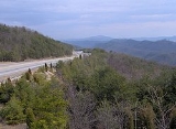
For its entire length, Clinch Mountain only has two true gaps during which the ridge is completely sliced in half and continues as Clinch Mountain on either side, divided by a creek. One of those is Moccasin Gap
at Weber City, Virginia (the Norfolk Southern Railway
and U.S. Highways 23-58-421 utilize that crossing because there is no elevation in the division of the mountain). Moccasin Gap is currently planned to undergo major mountain removal to accommodate a planned highway project. The natural appearance of the gap will be altered significantly. The second true gap in Clinch Mountain is Little Moccasin Gap, 30 miles northeast of Moccasin Gap, where U.S. Highway 58 Alternate crosses between Hansonville and Abingdon
, Virginia.
All other transportation crossings, as noted below, require an elevation climb to the top of the Clinch Mountain.
When U.S. Highway 25E was realigned into a four-lane highway northwest of Bean Station, Tennessee in the 1980s, it was necessary to cut a new gap into the top of Clinch Mountain, which lowered the original gap elevation by 200 feet. That realignment, along with the lowering of Interstate 26
-U.S. Highway 23 at Sams Gap on the Tennessee-North Carolina border, are the only instances of a highway gap in Tennessee actually lowering an original gap where a state or federal highway was built through. (Sams Gap was lowered by 150 feet to accommodate the new Interstate 26 highway).
, which was named after an unknown pioneer. The earliest known reference to the name is in the journal of Dr. Thomas Walker
: "Clinch's River, from one Clinch a hunter" (Stewart, 1967:146).
The Wilderness Road
to the Cumberland Gap
crossed Clinch Mountain at Moccasin Gap
, which Moccasin Creek flows through to join the Holston River
to the south.
Signal Point peak at the southern terminus of Clinch Mountain was used to signal troops during the Civil War. The mountains along the Clinch Mountain Ridge also played an important role in the Battle of Bean's Station. Apart from battles, the mountains in Grainger County, Tennessee had prominence in the late 1800s when the mineral springs in the area drew notable visitors from around the globe. Tate Springs, as the town and resort were named, included an enormous hotel, golf course and mineral baths. The seasonal resort even had its own spur on the railroad, so visitors could easily make the trip from all over the country. Notable guests included the Fords, Studebakers, Mellons, Firestones and Rockefellers. Because of a devastating fire and the Great Depression, only a few buildings survive today.
immortalized the mountain in their 1928 song "My Clinch Mountain Home." A fiddle
tune called "Clinch Mountain Backstep" (attributed to Ralph Stanley
http://www.ibiblio.org/fiddlers/CIA_CNU.htm) is in the Appalachian folk repertoire. Also, the first line of the classic folk song "Rye Whiskey" begins, "Way up on Clinch Mountain I wandered alone - I'm drunk as a devil and a long way from home."
Tennessee
Virginia
Mountain
Image:Himalaya_annotated.jpg|thumb|right|The Himalayan mountain range with Mount Everestrect 58 14 160 49 Chomo Lonzorect 200 28 335 52 Makalurect 378 24 566 45 Mount Everestrect 188 581 920 656 Tibetan Plateaurect 250 406 340 427 Rong River...
ridge
Ridge
A ridge is a geological feature consisting of a chain of mountains or hills that form a continuous elevated crest for some distance. Ridges are usually termed hills or mountains as well, depending on size. There are several main types of ridges:...
in the U.S. state
U.S. state
A U.S. state is any one of the 50 federated states of the United States of America that share sovereignty with the federal government. Because of this shared sovereignty, an American is a citizen both of the federal entity and of his or her state of domicile. Four states use the official title of...
s of Tennessee
Tennessee
Tennessee is a U.S. state located in the Southeastern United States. It has a population of 6,346,105, making it the nation's 17th-largest state by population, and covers , making it the 36th-largest by total land area...
and Virginia
Virginia
The Commonwealth of Virginia , is a U.S. state on the Atlantic Coast of the Southern United States. Virginia is nicknamed the "Old Dominion" and sometimes the "Mother of Presidents" after the eight U.S. presidents born there...
, lying in the ridge-and-valley
Ridge-and-valley Appalachians
The Ridge-and-Valley Appalachians, also called the Ridge and Valley Province or the Valley and Ridge Appalachians, are a physiographic province of the larger Appalachian division and are also a belt within the Appalachian Mountains extending from southeastern New York through northwestern New...
section of the Appalachian Mountains
Appalachian Mountains
The Appalachian Mountains #Whether the stressed vowel is or ,#Whether the "ch" is pronounced as a fricative or an affricate , and#Whether the final vowel is the monophthong or the diphthong .), often called the Appalachians, are a system of mountains in eastern North America. The Appalachians...
. From its southern terminus at Signal Point peak, which lies at the intersection of Knox, Union and Grainger counties near Blaine, Tennessee
Blaine, Tennessee
Blaine is a town in Grainger County, Tennessee, United States. It is part of the Morristown, Tennessee Metropolitan Statistical Area. The population was 1,856 at the 2010 census, an increase of 271 individuals since the 2000 census.-Geography:...
, it runs in a generally east-northeasterly direction to Garden Mountain near Burke's Garden, Virginia
Burke's Garden, Virginia
Burke's Garden or Burke Garden is an upland valley and unincorporated community in Tazewell County, Virginia, United States.-Geography:The oval, bowl-like valley is known for its fertile land and was once the bed of an ancient sea...
. It separates the Clinch River
Clinch River
The Clinch River rises in Southwest Virginia near Tazewell, Virginia and flows southwest through the Great Appalachian Valley, gathering various tributaries including the Powell River before joining the Tennessee River in East Tennessee.-Course:...
basin, to the north, and the Holston River
Holston River
The Holston River is a major river system of southwestern Virginia and east Tennessee. The three major forks of the Holston rise in southwestern Virginia and have their confluence near Kingsport, Tennessee. The North Fork flows southwest from Sharon Springs in Bland County, Virginia...
basin, to the south.
Geography
Knob Mountain
Knob Mountain may refer to:* Knob Mountain * Knob Mountain * Knob Mountain * Knob Mountain * Knob Mountain * Knob Mountain...
, as well as four high point summits above 4,000 feet (Beartown Mountain, Flattop Mountain
Flattop Mountain
Flattop Mountain and Flat Top Mountain may refer to*in the United States:NameStateCountyCoordinatesUSGS 7.5' MapFlattop Mountain AKMunicipality of AnchorageAnchorage A-8 SE...
, Morris Knob, and Chimney Rock Peak).
For its entire length, Clinch Mountain only has two true gaps during which the ridge is completely sliced in half and continues as Clinch Mountain on either side, divided by a creek. One of those is Moccasin Gap
Moccasin Gap
Moccasin Gap is a gap in Clinch Mountain near Gate City, Virginia, United States, the county seat of Scott County.Daniel Boone's Wilderness Road once traveled through the gap, on its way north from the Long Island of the Holston River, located to the south in Tennessee, towards the well-known...
at Weber City, Virginia (the Norfolk Southern Railway
Norfolk Southern Railway
The Norfolk Southern Railway is a Class I railroad in the United States, owned by the Norfolk Southern Corporation. With headquarters in Norfolk, Virginia, the company operates 21,500 route miles in 22 eastern states, the District of Columbia and the province of Ontario, Canada...
and U.S. Highways 23-58-421 utilize that crossing because there is no elevation in the division of the mountain). Moccasin Gap is currently planned to undergo major mountain removal to accommodate a planned highway project. The natural appearance of the gap will be altered significantly. The second true gap in Clinch Mountain is Little Moccasin Gap, 30 miles northeast of Moccasin Gap, where U.S. Highway 58 Alternate crosses between Hansonville and Abingdon
Abingdon, Virginia
Abingdon is a town in Washington County, Virginia, USA, 133 miles southwest of Roanoke. The population was 8,191 at the 2010 census. It is the county seat of Washington County and is a designated Virginia Historic Landmark...
, Virginia.
All other transportation crossings, as noted below, require an elevation climb to the top of the Clinch Mountain.
When U.S. Highway 25E was realigned into a four-lane highway northwest of Bean Station, Tennessee in the 1980s, it was necessary to cut a new gap into the top of Clinch Mountain, which lowered the original gap elevation by 200 feet. That realignment, along with the lowering of Interstate 26
Interstate 26
Interstate 26 is a nominally east–west main route of the Interstate Highway System in the Southeastern United States. I-26 runs from the junction of U.S. Route 11W and U.S. Route 23 in Kingsport, Tennessee, generally southeastward to U.S. Route 17 in Charleston, South Carolina...
-U.S. Highway 23 at Sams Gap on the Tennessee-North Carolina border, are the only instances of a highway gap in Tennessee actually lowering an original gap where a state or federal highway was built through. (Sams Gap was lowered by 150 feet to accommodate the new Interstate 26 highway).
History
Clinch Mountain is named after the Clinch RiverClinch River
The Clinch River rises in Southwest Virginia near Tazewell, Virginia and flows southwest through the Great Appalachian Valley, gathering various tributaries including the Powell River before joining the Tennessee River in East Tennessee.-Course:...
, which was named after an unknown pioneer. The earliest known reference to the name is in the journal of Dr. Thomas Walker
Thomas Walker (explorer)
Dr. Thomas Walker was a physician and explorer from Virginia who led an expedition to what is now the region beyond the Allegheny Mountains area of British North America in the mid-18th century...
: "Clinch's River, from one Clinch a hunter" (Stewart, 1967:146).
The Wilderness Road
Wilderness Road
The Wilderness Road was the principal route used by settlers for more than fifty years to reach Kentucky from the East. In 1775, Daniel Boone blazed a trail for the Transylvania Company from Fort Chiswell in Virginia through the Cumberland Gap into central Kentucky. It was later lengthened,...
to the Cumberland Gap
Cumberland Gap
Cumberland Gap is a pass through the Cumberland Mountains region of the Appalachian Mountains, also known as the Cumberland Water Gap, at the juncture of the U.S. states of Tennessee, Kentucky, and Virginia...
crossed Clinch Mountain at Moccasin Gap
Moccasin Gap
Moccasin Gap is a gap in Clinch Mountain near Gate City, Virginia, United States, the county seat of Scott County.Daniel Boone's Wilderness Road once traveled through the gap, on its way north from the Long Island of the Holston River, located to the south in Tennessee, towards the well-known...
, which Moccasin Creek flows through to join the Holston River
Holston River
The Holston River is a major river system of southwestern Virginia and east Tennessee. The three major forks of the Holston rise in southwestern Virginia and have their confluence near Kingsport, Tennessee. The North Fork flows southwest from Sharon Springs in Bland County, Virginia...
to the south.
Signal Point peak at the southern terminus of Clinch Mountain was used to signal troops during the Civil War. The mountains along the Clinch Mountain Ridge also played an important role in the Battle of Bean's Station. Apart from battles, the mountains in Grainger County, Tennessee had prominence in the late 1800s when the mineral springs in the area drew notable visitors from around the globe. Tate Springs, as the town and resort were named, included an enormous hotel, golf course and mineral baths. The seasonal resort even had its own spur on the railroad, so visitors could easily make the trip from all over the country. Notable guests included the Fords, Studebakers, Mellons, Firestones and Rockefellers. Because of a devastating fire and the Great Depression, only a few buildings survive today.
Music
The Carter FamilyCarter Family
The Carter Family was a traditional American folk music group that recorded between 1927 and 1956. Their music had a profound impact on bluegrass, country, Southern Gospel, pop and rock musicians as well as on the U.S. folk revival of the 1960s. They were the first vocal group to become country...
immortalized the mountain in their 1928 song "My Clinch Mountain Home." A fiddle
Fiddle
The term fiddle may refer to any bowed string musical instrument, most often the violin. It is also a colloquial term for the instrument used by players in all genres, including classical music...
tune called "Clinch Mountain Backstep" (attributed to Ralph Stanley
Ralph Stanley
Ralph Stanley , also known as Dr. Ralph Stanley, is an American bluegrass artist, known for his distinctive singing and banjo playing.-Biography:...
http://www.ibiblio.org/fiddlers/CIA_CNU.htm) is in the Appalachian folk repertoire. Also, the first line of the classic folk song "Rye Whiskey" begins, "Way up on Clinch Mountain I wandered alone - I'm drunk as a devil and a long way from home."
Transportation crossings
The following crossings of Clinch Mountain can be made, from southwest to northeast:Tennessee
- Joppa Mountain Road connects JoppaJoppa, TennesseeJoppa is an unincorporated community in rural west-central Grainger County, Tennessee, United States that rests below Joppa Mountain, a subrange of the 150 mile long Clinch Mountain Ridge. It is part of the Morristown, Tennessee Metropolitan Statistical Area.-History:It's situated along the...
and Powder Springs via Powder Spring Gap.
- U.S. Highway 25E (State Route 32) connects Rock Haven and Thorn HillThorn Hill, TennesseeThorn Hill is an unincorporated community in rural northeastern Grainger County, Tennessee, United States. It is part of the Morristown, Tennessee Metropolitan Statistical Area. The 2010 United States Census reported the population of Thorn Hill to be 1,236 at the time.-Education:The community of...
via Beans Gap. - State Route 31 connects Spruce Pine and the settlement of Flat GapFlat Gap, TennesseeFlat Gap is an unincorporated community located in Wayne County, Tennessee.. The community is just off of U.S. Route 64 near the Hardin County line.-Nearby Communities:*Houston, Tennessee*Olivehill, Tennessee*Clifton, Tennessee*Martin's Mills, Tennessee...
via Flat Gap. - State Route 66 connects Klondike and Lee Valley via Big War Gap.
- State Route 70 connects Alumwell and Frog Level via Little War Gap.
Virginia
- The CSX Kingsport SubdivisionKingsport SubdivisionThe Kingsport Subdivision is a 133.2-mile railroad line owned and operated by CSX Transportation in the U.S. states of Kentucky, Virginia, and Tennessee...
connects Kermit and Speers Ferry via the Clinch Mountain Tunnel. - U.S. Route 23/U.S. Route 58/U.S. Route 421 and the Norfolk Southern RailwayNorfolk Southern RailwayThe Norfolk Southern Railway is a Class I railroad in the United States, owned by the Norfolk Southern Corporation. With headquarters in Norfolk, Virginia, the company operates 21,500 route miles in 22 eastern states, the District of Columbia and the province of Ontario, Canada...
Appalachia Division connect Weber CityWeber City, VirginiaWeber City is an incorporated town in Scott County, Virginia, United States. The population was 1,327 at the 2010 census. It is part of the Kingsport–Bristol –Bristol Metropolitan Statistical Area, which is a component of the Johnson City–Kingsport–Bristol, TN-VA Combined...
and Gate CityGate City, VirginiaGate City is a town in Scott County, Virginia, United States. The population was 2,034 at the 2010 census. It is the county seat of Scott County....
via Moccasin Gap. - State Route 612 connects MendotaMendota, VirginiaMendota is an unincorporated community in Washington County in the southwestern part of the U.S. state of Virginia. Elevation approx 1800 ft...
and Collinwood via Fugate Gap. - U.S. Route 19/U.S. Route 58 Alternate connects Holston and Hansonville via Little Moccasin Gap.
- State Route 80State Route 80 (Virginia)State Route 80 is a primary state highway in the southwest part of the U.S. state of Virginia. It runs from the Kentucky state line at Breaks Interstate Park east to U.S. Route 11 near Meadowview. Kentucky Route 80 and Missouri's Route 80 continue the number west to Matthews, Missouri.The entire...
connects the settlement of Hayters Gap and Rockdell via Hayters Gap. - State Route 91 connects TannersvilleTannersville, VirginiaTannersville is an unincorporated community in Tazewell County, Virginia, United States....
and Maiden Spring via an unnamed crossing. - State Route 16 connects Asberrys and Benbow via an unnamed crossing.