

U.S. Route 11E
Encyclopedia
U.S. Route 11E is a divided highway of US 11
in the U.S. states of Tennessee
and Virginia
. The U.S. Highway
, which is complemented by US 11W
to the north and west, runs 120.9 miles (194.6 km) from US 11, US 11W, and US 70
in Knoxville, Tennessee
north and east to US 11
, US 11E, US 19
, and US 421
in Bristol, Virginia
. US 11E connects Knoxville and the twin cities
of Bristol, Virginia and Bristol, Tennessee
with the East Tennessee
communities of Morristown
, Greeneville
, and Johnson City
. The U.S. Highway runs concurrently
with US 70 and US 25W east of Knoxville, US 321 from Greeneville and Johnson City, and both US 19W
and US 19
between Johnson City and Bristol. US 11E also has an unsigned
concurrency with Tennessee State Route 34 (SR 34) for almost all of its course in Tennessee.
and downtown Knoxville; US 11W heads northeast along Rutledge Pike. US 11E heads east together with US 70 as Asheville Highway, a four-lane divided highway that leaves the city of Knoxville at its diamond interchange
with Interstate 40
(I-40). US 11E and US 70 are joined by US 25W at the I-40 interchange; the three highways use the J. Will Taylor Bridge to cross the Holston River
and meet the eastern end of SR 168 (Governor John Sevier Highway). At Trentville, US 25W and US 70 continue east as Asheville Highway while US 11E splits northeast as four-lane divided Andrew Johnson Highway. The U.S. Highway crosses the Knox
–Jefferson
county line just west of Strawberry Fields, where the highway intersects SR 139 (Old Dandridge Pike).
US 11E passes through the town of New Market
on its way to Jefferson City, which contains Carson-Newman College
. At the west end of the town, the U.S. Highway intersects SR 92, which follows a part of US 11E's old alignment, Old Andrew Johnson Highway. SR 92 runs concurrently with US 11E to south of downtown Jefferson City, where it heads south toward the county seat
of Dandridge
. US 11E crosses over Norfolk Southern Railway
's Knoxville East District and enters Hamblen County at Talbott
, where the highway intersects SR 341 (Talbott Kansas Road). The U.S. Highway continues through Alpha
, the site of several industrial parks, Moore-Murrell Airport
, and the highway's southern intersection with SR 342 (Air Park Boulevard). The two highways run concurrently until SR 342 heads north as Panther Creek Road toward Panther Creek State Park
just west of the city limits of Morristown.
(Fairmont Avenue). US 11E intersects SR 343 (Cumberland Street) and passes College Square Mall
before reaching a partial cloverleaf interchange with US 25E
(Davy Crockett Parkway). US 11E heads north along the freeway for 0.5 mile (0.80467 km) before another partial cloverleaf interchange where the highway becomes concurrent with SR 66 along Andrew Johnson Highway. The two highways closely parallel the railroad line as a two-lane road and leave the city limits of Morristown just west of Russellville
, where SR 344 splits northeast along Old Russellville Pike. US 11E and SR 66 pass through Whitesburg
shortly before curving southeast and entering Hawkins County
. The U.S. and state highways diverge in the town of Bulls Gap
shortly before US 11E crosses a perpendicular rail line and follows the Knoxville East District through Bulls Gap, a low point in Bays Mountain
.
US 11E continues southeast into Greene County, where the highway expands to a four-lane divided highway as it passes Volunteer Raceway and has a diamond interchange with I-81
. The U.S. Highway crosses Lick Creek and passes through the town of Mosheim
before reaching the town of Greeneville, the home of Andrew Johnson National Historic Site
. West of the town, US 11E has a partial cloverleaf interchange with Blue Springs Parkway, which heads east as US 11E Business and SR 70
. SR 70 joins the U.S. Highway for a short distance before heading north as Lonesome Pine Trail. US 11E has an interchange with SR 172 (Baileyton Road) before closely spaced intersections with US 321 (Main Street), which joins US 11E in a concurrency, and the southern terminus of SR 93 (Kingsport Highway). After crossing the Knoxville East rail line, the U.S. Highway receives the eastern end of its business route and SR 107
(Tusculum Boulevard). SR 107 runs concurrently with the U.S. Highways east to Tusculum
, where the state highway heads east as Erwin Highway and passes Tusculum College
.
US 11E and US 321 head northeast and cross over the rail line at Afton
. The two highways intersect SR 351 (Rheatown Road) north of the community of Chuckey
. The U.S. Highways also pass to the north of Davy Crockett Birthplace State Park
before entering Washington County, where the highways pass along the north edge of Limestone
, meet the south end of SR 75 (Opie Arnold Road), and cross Big Limestone Creek. US 11E and US 321 intersect SR 81 (College Street) and SR 354 (Boones Creek Road) on the west and east sides, respectively, of the town of Jonesborough
. The U.S. Highways enter the city of Johnson City at their crossing of a north–south rail line. Just east of the city limits, where US 11E becomes Market Street, US 321 turns south onto State of Franklin Road, a western boulevard bypass of Johnson City that heads north as SR 381. US 11E passes to the north of Mountain Home
, the site of several hospitals, including a VA medical center
. East of University Boulevard, which serves the campus of East Tennessee State University
, the U.S. Highway curves north while SR 91 continues east along the one-way pair
of Main Street and Market Street to serve downtown Johnson City.
 US 11E heads north past Science Hill High School
to Roan Street, the main north–south street of downtown Johnson City that the U.S. Highway joins. The highway passes the Mall at Johnson City
and meets I-26
and US 23 at a partial cloverleaf interchange. US 19W joins US 11E at the interchange; when Roan Street continues north as SR 36, the two U.S. Highways curve northeast as Bristol Highway, which meets the northern end of SR 381 (State of Franklin Road) at an interchange just outside the city limits. The highways head northeast and cross the Watauga River
arm of Boone Lake
and enter Sullivan County. North of Piney Flats
, US 11E and US 19W curve north while SR 44
(Bluff City Highway) continues northeast into the town of Bluff City
. Just north of SR 44, the U.S. Highways meet the northern end of US 19E; US 11E continues north concurrent with mainline US 19 and crosses the South Fork Holston River.
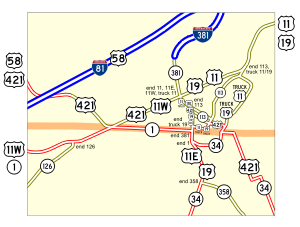
US 11E and US 19 have a diamond interchange with SR 394 just west of the state highway's junction with SR 390 (Bluff City Highway). The U.S. Highways cross Beaver Creek adjacent to Bristol Motor Speedway
and follow the stream's valley between the Whitetop Knobs to the east and the Beaver Creek Knobs to the west. US 11E and US 19 enter the city of Bristol and follow Volunteer Parkway to the Tennessee–Virginia state line. State Street, which heads west as SR 1, follows the boundary and serves as the main street of both cities Bristol. The two U.S. Highways and Virginia State Route 381
(SR 381) head north into the independent city
of Bristol along Commonwealth Avenue, a four-lane divided highway that intersects Goode Street one block north of the state line; Goode Street carries US 421 and both US 11 Truck and US 19 Truck through the Bristol Commercial Historic District
. US 11E, US 19, US 421, and SR 381 meet the southern end of SR 113
at separate intersections: Cumberland Street carries northbound SR 113 east and Sycamore Street carries the westbound direction. The four highways continue north to east–west Euclid Avenue, where US 11E has its northern terminus. SR 381 continues north along Commonwealth Avenue to the southern end of I-381
, a spur south from I-81. Westbound Euclid Avenue heads west carrying northbound US 421 and southbound US 11W. At this intersection, US 11E and US 11W come together to form mainline US 11, which follows eastbound Euclid Avenue with northbound US 19.
!County
!Location
!Mile
!Destinations
!Notes
|-
|rowspan=4|Knox
|rowspan=3|Knoxville
|0.0
|
|Southern terminus of US 11E; US 11E and US 11W come together to form US 11; south end of concurrency with US 70
|-
|2.0
|
|I-40 Exit 394; south end of concurrency with US 25W
|-
|3.0
|
|
|-
|Trentville
|8.1
|
|East end of concurrencies with US 25W and US 70
|-
|rowspan=3|Jefferson
|Strawberry Plains
|12.3
|
|
|-
|rowspan=2|Jefferson City
|21.9
|
|South end of concurrency with SR 92
|-
|23.2
|
|North end of concurrency with SR 92
|-
|rowspan=9|Hamblen
|Talbott
|28.4
|
|
|-
|rowspan=6|Morristown
|30.5
|
|South end of concurrency with SR 342
|-
|31.7
|
|North end of concurrency with SR 342
|-
|36.1
|
|
|-
|37.1
|
|
|-
|39.1
|
|Partial cloverleaf interchange; south end of concurrency with US 25E
|-
|39.5
|
|Partial cloverleaf interchange; north end of concurrency with US 25E; south end of concurrency with SR 66
|-
|Russellville
|43.2
|
|
|-
|Whitesburg
|47.3
|
|
|-
|Hawkins
|Bulls Gap
|50.5
|
|North end of concurrency with SR 66
|-
|rowspan=9|Greene
|
|54.2
|
|I-81 Exit 23
|-
|rowspan=6|Greeneville
|65.7
|
|Partial cloverleaf interchange; south end of concurrency with SR 70
|-
|66.2
|
|North end of concurrency with SR 70
|-
|67.4
|
|Interchange
|-
|67.8
|
|South end of concurrency with US 321
|-
|67.9
|
|
|-
|69.7
|
|South end of concurrency with SR 107
|-
|Tusculum
|70.5
|
|North end of concurrency with SR 107
|-
|Chuckey
|76.9
|
|
|-
|rowspan=8|Washington
|Limestone
|80.5
|
|
|-
|rowspan=2|Jonesborough
|89.7
|
|
|-
|90.6
|
|
|-
|rowspan=5|Johnson City
|95.4
|
|North end of concurrency with US 321
|-
|96.6
|
|
|-
|98.8
|
|I-26 Exit 20; south end of concurrency with US 19W
|-
|99.6
|
|
|-
|100.4
|
|
|-
|rowspan=3|Sullivan
|rowspan=2|Bluff City
|108.1
|
|
|-
|108.5
|
|North end of concurrency with US 19W; south end of concurrency with US 19
|-
|Bristol
|112.2
|
|Diamond interchange
|-
|colspan=2|Tennessee
–Virginia
state line
|120.3
0.00
|
|South end of concurrency with SR 381
|-
|rowspan=3 colspan=2|City of Bristol
|0.08
|
|South end of concurrency with US 421
|-
|0.23
|
|
|-
|0.58
|
|Northern terminus of US 11E; US 11E and US 11W come together to form US 11
of US 11E in Tennessee. The highway runs 4.6 miles (7.4 km) between junctions with US 11E on the west and east sides of Greeneville. US 11E Business begins at a partial cloverleaf interchange with US 11E (Andrew Johnson Highway) and SR 70. East of where SR 70 splits to the south, the business route enters the town as Summer Street. In the downtown area, US 11E Business turns north onto Main Street, joining US 321 and SR 107. The business route and SR 107 turn east onto Tusculum Boulevard, which they follow out of the town to the business route's eastern terminus at US 11E.
U.S. Route 11
U.S. Route 11 is a north–south United States highway extending 1,645 miles across the eastern United States. The southern terminus of the route is at U.S. Route 90 in the Bayou Sauvage National Wildlife Refuge in eastern New Orleans, Louisiana. The northern terminus is at the United...
in the U.S. states of Tennessee
Tennessee
Tennessee is a U.S. state located in the Southeastern United States. It has a population of 6,346,105, making it the nation's 17th-largest state by population, and covers , making it the 36th-largest by total land area...
and Virginia
Virginia
The Commonwealth of Virginia , is a U.S. state on the Atlantic Coast of the Southern United States. Virginia is nicknamed the "Old Dominion" and sometimes the "Mother of Presidents" after the eight U.S. presidents born there...
. The U.S. Highway
United States Numbered Highways
The system of United States Numbered Highways is an integrated system of roads and highways in the United States numbered within a nationwide grid...
, which is complemented by US 11W
U.S. Route 11W
U.S. Route 11W is a divided highway of US 11 in the U.S. states of Tennessee and Virginia. The U.S. Highway, which is complemented by US 11E to the south and east, runs from US 11, US 11E, and US 70 in Knoxville, Tennessee north and east to US 11, US 11E, US 19, and US 421 in Bristol, Virginia...
to the north and west, runs 120.9 miles (194.6 km) from US 11, US 11W, and US 70
U.S. Route 70 in Tennessee
US 70 enters Tennessee, as well as the city of Memphis, concurrent with Interstate 55, US 61, US 64, and US 79. At exit 12, the northernmost exit on I-55 in the state, I-55 turns south; however, the four US routes continue east onto the at-grade Crump Boulevard. US 61 splits from the concurrency...
in Knoxville, Tennessee
Knoxville, Tennessee
Founded in 1786, Knoxville is the third-largest city in the U.S. state of Tennessee, U.S.A., behind Memphis and Nashville, and is the county seat of Knox County. It is the largest city in East Tennessee, and the second-largest city in the Appalachia region...
north and east to US 11
U.S. Route 11 in Virginia
U.S. Route 11 in Virginia runs north–south through the western part of the state, parallel to Interstate 81.-History:What is now US 11 was added to the state highway system in 1918 as portions of State Route 10 and State Route 3 . SR 3 became State Route 33 in 1923, and US 11 was applied to...
, US 11E, US 19
U.S. Route 19 in Virginia
U.S. Route 19 is a part of the U.S. Highway System that runs from Memphis, Florida to Erie, Pennsylvania. In Virginia, the U.S. Highway runs between a pair of twin cities: Bristol, Tennessee and Bristol, Virginia at the Virginia–Tennessee state line, and Bluefield and Bluefield at the...
, and US 421
U.S. Route 421 in Virginia
U.S. Route 421 is a part of the U.S. Highway System that runs from Fort Fisher, North Carolina to Michigan City, Indiana. In Virginia, the U.S. Highway runs from the Tennessee state line between the twin cities of Bristol, Tennessee and Bristol, Virginia north and west to the Kentucky state line...
in Bristol, Virginia
Bristol, Virginia
Bristol is an independent city in Virginia, United States, bounded by Washington County, Virginia, Bristol, Tennessee, and Sullivan County, Tennessee....
. US 11E connects Knoxville and the twin cities
Twin cities
Twin cities are a special case of two cities or urban centres which are founded in close geographic proximity and then grow into each other over time...
of Bristol, Virginia and Bristol, Tennessee
Bristol, Tennessee
Bristol is a city in Sullivan County, Tennessee, United States. The population was 26,702 at the 2010 census. It is the twin city of Bristol, Virginia, which lies directly across the state line between Tennessee and Virginia. The boundaries of both cities run parallel to each other along State...
with the East Tennessee
East Tennessee
East Tennessee is a name given to approximately the eastern third of the U.S. state of Tennessee, one of the three Grand Divisions of Tennessee defined in state law. East Tennessee consists of 33 counties, 30 located within the Eastern Time Zone and three counties in the Central Time Zone, namely...
communities of Morristown
Morristown, Tennessee
Morristown is a city in, and the county seat of, Hamblen County, Tennessee, United States. The population was 29,137 at the 2010 United States Census. It is the principal city of the Morristown, Tennessee Metropolitan Statistical Area, which encompasses all of Grainger, Hamblen and Jefferson counties...
, Greeneville
Greeneville, Tennessee
Greeneville is a town in Greene County, Tennessee, United States. The population was 15,198 at the 2000 census. It is the county seat of Greene County. The town was named in honor of Revolutionary War hero Nathanael Greene. It is the only town with this spelling in the United States, although there...
, and Johnson City
Johnson City, Tennessee
Johnson City is a city in Carter, Sullivan, and Washington counties in the U.S. state of Tennessee, with most of the city being in Washington County...
. The U.S. Highway runs concurrently
Concurrency (road)
A concurrency, overlap, or coincidence in a road network is an instance of one physical road bearing two or more different highway, motorway, or other route numbers...
with US 70 and US 25W east of Knoxville, US 321 from Greeneville and Johnson City, and both US 19W
U.S. Route 19W
U.S. Route 19W traverses approximately from Cane River, North Carolina to Bluff City, Tennessee.-Route description:US 19W begins in western Yancey county at the community of Cane River, at the intersection of US 19/US 19E. Several signs at the beginning of the route strongly recommend truckers...
and US 19
U.S. Route 19 in Tennessee
U.S. Route 19 in Tennessee traverses approximately across the Tri-Cities area of East Tennessee; from Elk Park, North Carolina, at the North Carolina state line, to the Virginia state line in Bristol...
between Johnson City and Bristol. US 11E also has an unsigned
Unsigned highway
An unsigned highway is a highway that has been assigned a route number, but does not bear conventional road markings that would normally be used to identify the route with that number...
concurrency with Tennessee State Route 34 (SR 34) for almost all of its course in Tennessee.
Knoxville to Morristown
US 11E begins at an intersection with the northern terminus of mainline US 11 in Tennessee, the southern end of US 11W, and US 70 in Knoxville. US 11 and US 70 head west as Magnolia Avenue toward the Knoxville ZooKnoxville Zoo
Knoxville Zoo is a zoo located just east of downtown Knoxville, Tennessee near exit 392 of Interstate 40. The zoo is home to about 800 animals and welcomes over 400,000 human visitors each year....
and downtown Knoxville; US 11W heads northeast along Rutledge Pike. US 11E heads east together with US 70 as Asheville Highway, a four-lane divided highway that leaves the city of Knoxville at its diamond interchange
Diamond interchange
A diamond interchange is a common type of road junction, used where a freeway crosses a minor road. The freeway itself is grade-separated from the minor road, one crossing the other over a bridge...
with Interstate 40
Interstate 40 in Tennessee
In the state of Tennessee, Interstate 40 traverses the entirety of the state from west to east, running from the Mississippi River at the Arkansas border to the northern base of the Great Smoky Mountains at the North Carolina border...
(I-40). US 11E and US 70 are joined by US 25W at the I-40 interchange; the three highways use the J. Will Taylor Bridge to cross the Holston River
Holston River
The Holston River is a major river system of southwestern Virginia and east Tennessee. The three major forks of the Holston rise in southwestern Virginia and have their confluence near Kingsport, Tennessee. The North Fork flows southwest from Sharon Springs in Bland County, Virginia...
and meet the eastern end of SR 168 (Governor John Sevier Highway). At Trentville, US 25W and US 70 continue east as Asheville Highway while US 11E splits northeast as four-lane divided Andrew Johnson Highway. The U.S. Highway crosses the Knox
Knox County, Tennessee
Knox County is a county in the U.S. state of Tennessee. Its 2007 population was estimated at 423,874 by the United States Census Bureau. Its county seat is Knoxville, as it has been since the creation of the county. The county is at the geographical center of the Great Valley of East Tennessee...
–Jefferson
Jefferson County, Tennessee
*...
county line just west of Strawberry Fields, where the highway intersects SR 139 (Old Dandridge Pike).
US 11E passes through the town of New Market
New Market, Tennessee
New Market is a town in Jefferson County, Tennessee, United States. It is part of the Morristown, Tennessee Metropolitan Statistical Area. The population was 1,234 at the 2000 census.-Geography:New Market is located at ....
on its way to Jefferson City, which contains Carson-Newman College
Carson-Newman College
Carson–Newman College is a historically Baptist liberal arts college located in Jefferson City, Tennessee, United States. Enrollment as of 2006-2007 was about 2,050. The college's students come from 44 U.S. states and 30 other countries. Studies are offered in approximately 90 different academic...
. At the west end of the town, the U.S. Highway intersects SR 92, which follows a part of US 11E's old alignment, Old Andrew Johnson Highway. SR 92 runs concurrently with US 11E to south of downtown Jefferson City, where it heads south toward the county seat
County seat
A county seat is an administrative center, or seat of government, for a county or civil parish. The term is primarily used in the United States....
of Dandridge
Dandridge, Tennessee
Dandridge is a town in Jefferson County, Tennessee, United States. It is the county seat of Jefferson County. It is part of the Morristown, Tennessee Metropolitan Statistical Area....
. US 11E crosses over Norfolk Southern Railway
Norfolk Southern Railway
The Norfolk Southern Railway is a Class I railroad in the United States, owned by the Norfolk Southern Corporation. With headquarters in Norfolk, Virginia, the company operates 21,500 route miles in 22 eastern states, the District of Columbia and the province of Ontario, Canada...
's Knoxville East District and enters Hamblen County at Talbott
Talbott, Tennessee
Talbott is a small unincorporated community in Hamblen and Jefferson counties in the U.S. state of Tennessee. A post office and Talbott Elementary School are located in Talbott....
, where the highway intersects SR 341 (Talbott Kansas Road). The U.S. Highway continues through Alpha
Alpha, Tennessee
Alpha is an unincorporated community in Hamblen County, Tennessee. It is located at and around the junction of Highway 11-E and Tennessee State Route 160 between Morristown and Jefferson City....
, the site of several industrial parks, Moore-Murrell Airport
Moore-Murrell Airport
Moore-Murrell Airport is a city-owned public-use airport located four nautical miles southwest of the central business district of Morristown, a city in Hamblen County, Tennessee, United States. It was opened in 1953...
, and the highway's southern intersection with SR 342 (Air Park Boulevard). The two highways run concurrently until SR 342 heads north as Panther Creek Road toward Panther Creek State Park
Panther Creek State Park
Panther Creek State Park is a Tennessee state park northwest of Morristown, on the shore of Cherokee Reservoir, an impoundment of the Holston River.The park has an area of approximately .-External links:...
just west of the city limits of Morristown.
Morristown to Johnson City
US 11E heads through a commercial area along Andrew Johnson Highway to west of downtown Morristown, where the highway turns southeast onto Morris Boulevard, a five-lane road with center turn lane that crosses the railroad tracks and passes through an industrial area where the highway intersects SR 66Tennessee State Route 66
State Route 66 is a state-maintained highway in eastern Tennessee, including a four-lane divided highway segment in Sevier County and a two-lane segment through mountainous terrain to the northeast.- Route description :...
(Fairmont Avenue). US 11E intersects SR 343 (Cumberland Street) and passes College Square Mall
College Square Mall
College Square is an indoor regional shopping mall located in Morristown, Tennessee.College Square is owned and managed by CBL & Associates. It features approximately 70 stores and restaurants including Carmike College Square Cinemas 12....
before reaching a partial cloverleaf interchange with US 25E
U.S. Route 25E
U.S. Route 25E is the eastern branch of U.S. Route 25 from Newport, Tennessee, where US 25 splits into US 25E and US 25W, to North Corbin, Kentucky, where the two highways rejoin...
(Davy Crockett Parkway). US 11E heads north along the freeway for 0.5 mile (0.80467 km) before another partial cloverleaf interchange where the highway becomes concurrent with SR 66 along Andrew Johnson Highway. The two highways closely parallel the railroad line as a two-lane road and leave the city limits of Morristown just west of Russellville
Russellville, Tennessee
Russellville is an unincorporated community in Hamblen County, Tennessee, United States. Located along U.S. Route 11E, it lies approximately midway between Whitesburg and Morristown.-History:...
, where SR 344 splits northeast along Old Russellville Pike. US 11E and SR 66 pass through Whitesburg
Whitesburg, Tennessee
Whitesburg is an unincorporated community in eastern Hamblen County, Tennessee. The small, rural community is located along U.S. Route 11E. Whitesburg is bordered by Russellville on the west and Bulls Gap on the east. A U.S. post office, Whitesburg Elementary School and East Ridge Middle School,...
shortly before curving southeast and entering Hawkins County
Hawkins County, Tennessee
Hawkins County is a county located in the U.S. state of Tennessee. As of 2010, the population was 56,833. Its county seat is Rogersville, Tennessee's second-oldest town....
. The U.S. and state highways diverge in the town of Bulls Gap
Bulls Gap, Tennessee
Bulls Gap is a town in Hawkins County, Tennessee, United States. The population was 714 at the 2000 census. It is part of the Kingsport–Bristol –Bristol Metropolitan Statistical Area, which is a component of the Johnson City–Kingsport–Bristol, TN-VA Combined Statistical...
shortly before US 11E crosses a perpendicular rail line and follows the Knoxville East District through Bulls Gap, a low point in Bays Mountain
Bays Mountain
Bays Mountain is a ridge of the Ridge-and-Valley Appalachians, located in eastern Tennessee. It runs southwest to northeast, from just south of Knoxville to Kingsport.Its southern segment is relatively low in elevation...
.
US 11E continues southeast into Greene County, where the highway expands to a four-lane divided highway as it passes Volunteer Raceway and has a diamond interchange with I-81
Interstate 81 in Tennessee
Interstate 81 is an long expressway stretching from Dandridge, Tennessee northward to the Thousand Islands Bridge at the United States-Canada border near Fishers Landing, New York...
. The U.S. Highway crosses Lick Creek and passes through the town of Mosheim
Mosheim, Tennessee
Mosheim is a town in Greene County, Tennessee, United States. The population was 1,749 at the 2000 census.-Geography:Mosheim is located at .According to the United States Census Bureau, the town has a total area of , all of it land....
before reaching the town of Greeneville, the home of Andrew Johnson National Historic Site
Andrew Johnson National Historic Site
Andrew Johnson National Historic Site is a National Historic Site in Greeneville, Tennessee, maintained by the National Park Service. It was established to honor Andrew Johnson, 17th President of the United States, who became president after Abraham Lincoln's death...
. West of the town, US 11E has a partial cloverleaf interchange with Blue Springs Parkway, which heads east as US 11E Business and SR 70
Tennessee State Route 70
State Route 70 is a state-maintained highway in eastern Tennessee, beginning at the border with North Carolina in the midst of the Cherokee National Forest and the Great Smokey Mountains and ending at the Virginia border in the extremely rural and mountainous terrain of Hancock County.The highway...
. SR 70 joins the U.S. Highway for a short distance before heading north as Lonesome Pine Trail. US 11E has an interchange with SR 172 (Baileyton Road) before closely spaced intersections with US 321 (Main Street), which joins US 11E in a concurrency, and the southern terminus of SR 93 (Kingsport Highway). After crossing the Knoxville East rail line, the U.S. Highway receives the eastern end of its business route and SR 107
Tennessee State Route 107
State Route 107 is a state highway in eastern Tennessee, United States. It begins at an intersection with Round Mountain Road south of Del Rio and ends at the North Carolina state line east of Unicoi, where it becomes NC 226....
(Tusculum Boulevard). SR 107 runs concurrently with the U.S. Highways east to Tusculum
Tusculum, Tennessee
Tusculum is a city in Greene County, Tennessee, United States. The population was 2,004 at the 2000 census. It is the home of Tusculum College, the oldest university in Tennessee and the 28th oldest in the United States...
, where the state highway heads east as Erwin Highway and passes Tusculum College
Tusculum College
Tusculum College is a coeducational private college affiliated with the Presbyterian Church , with its main campus in Tusculum, Tennessee, United States, a suburb of Greeneville...
.
US 11E and US 321 head northeast and cross over the rail line at Afton
Afton, Tennessee
Afton is an unincorporated community in Greene County, Tennessee. It is believed that the community's name comes from Robert Burns's song "Sweet Afton", about the River Afton in Scotland....
. The two highways intersect SR 351 (Rheatown Road) north of the community of Chuckey
Chuckey, Tennessee
Chuckey is an unincorporated community in Greene County, Tennessee. It is located on the Nolichucky River, from which its name is derived. The community is the site of a post office and is assigned zip code 37641....
. The U.S. Highways also pass to the north of Davy Crockett Birthplace State Park
Davy Crockett Birthplace State Park
Davy Crockett Birthplace State Park is a state park in Greene County, Tennessee. Situated along the Nolichucky River, the park consists of centered around the traditional birthplace of legendary Tennessee frontiersman, soldier, and politician Davy Crockett...
before entering Washington County, where the highways pass along the north edge of Limestone
Limestone, Tennessee
Limestone is an unincorporated community on the western border of Washington County and the eastern border of Greene County in the northeastern part of the U.S. state of Tennessee. Its zip code is 37681...
, meet the south end of SR 75 (Opie Arnold Road), and cross Big Limestone Creek. US 11E and US 321 intersect SR 81 (College Street) and SR 354 (Boones Creek Road) on the west and east sides, respectively, of the town of Jonesborough
Jonesborough, Tennessee
Jonesborough is a town in and the county seat of Washington County, Tennessee, in the southeastern United States. The population was 4,168 at the 2000 census...
. The U.S. Highways enter the city of Johnson City at their crossing of a north–south rail line. Just east of the city limits, where US 11E becomes Market Street, US 321 turns south onto State of Franklin Road, a western boulevard bypass of Johnson City that heads north as SR 381. US 11E passes to the north of Mountain Home
Mountain Home, Tennessee
Mountain Home, Tennessee, zip code 37684, is a separate postal zone consisting of the grounds of the Mountain Home VA hospital and Mountain Home National Cemetery, which also includes classrooms and administrative buildings of the medical and pharmacy school of East Tennessee State University. It...
, the site of several hospitals, including a VA medical center
Veterans Health Administration
The Veterans Health Administration is the component of the United States Department of Veterans Affairs led by the Under Secretary of Veterans Affairs for Health that implements the medical assistance program of the VA through the administration and operation of numerous VA outpatient clinics,...
. East of University Boulevard, which serves the campus of East Tennessee State University
East Tennessee State University
East Tennessee State University is an accredited American university located in Johnson City, Tennessee. It is part of the Tennessee Board of Regents system of colleges and universities, the nation's sixth largest system of public education, and is the fourth largest university in the state...
, the U.S. Highway curves north while SR 91 continues east along the one-way pair
One-way pair
A one-way pair, one-way couple, or just couplet is a pair of parallel, usually one-way streets that carry opposite directions of a signed route or major traffic flow, or sometimes opposite directions of a bus or streetcar route....
of Main Street and Market Street to serve downtown Johnson City.
Johnson City to Bristol
Science Hill High School
Science Hill High School is a high school in Johnson City, Tennessee with an enrollment of approximately 2600 students. The school is split over three campuses: 9-12 Campus, Technical Center Campus, & Alternative School Campus. The school also shares space with Freedom Hall Civic Center...
to Roan Street, the main north–south street of downtown Johnson City that the U.S. Highway joins. The highway passes the Mall at Johnson City
Mall at Johnson City
The Mall at Johnson City is an enclosed shopping mall in Johnson City, Tennessee, United States. The mall features over 70 stores and a food court. It is managed by Glimcher Realty Trust...
and meets I-26
Interstate 26
Interstate 26 is a nominally east–west main route of the Interstate Highway System in the Southeastern United States. I-26 runs from the junction of U.S. Route 11W and U.S. Route 23 in Kingsport, Tennessee, generally southeastward to U.S. Route 17 in Charleston, South Carolina...
and US 23 at a partial cloverleaf interchange. US 19W joins US 11E at the interchange; when Roan Street continues north as SR 36, the two U.S. Highways curve northeast as Bristol Highway, which meets the northern end of SR 381 (State of Franklin Road) at an interchange just outside the city limits. The highways head northeast and cross the Watauga River
Watauga River
The Watauga River is a large stream of western North Carolina and East Tennessee. It is 60 miles long with its headwaters on the slopes of Grandfather Mountain and Peak Mountain in Watauga County, North Carolina.-Hydrography:...
arm of Boone Lake
Boone Lake
Boone Lake is a reservoir in Sullivan and Washington counties in northeastern Tennessee, formed by the impoundment of the South Fork Holston River behind Boone Dam....
and enter Sullivan County. North of Piney Flats
Piney Flats, Tennessee
Piney Flats is an unincorporated community in Sullivan County in the U.S. state of Tennessee. It is part of the Kingsport–Bristol –Bristol Metropolitan Statistical Area, which is a component of the Johnson City–Kingsport–Bristol, TN-VA Combined Statistical Area –...
, US 11E and US 19W curve north while SR 44
Tennessee State Route 44
State Route 44 is a state highway in the U.S. state of Tennessee. It runs from U.S. Highway 11E/U.S. Highway 19W/State Route 34 in Bluff City, just south of the split of US 19W and U.S. Highway 19E, northeast via Hickory Tree and Holston Valley to the Virginia state line, where it becomes State...
(Bluff City Highway) continues northeast into the town of Bluff City
Bluff City, Tennessee
Bluff City is a city in Sullivan County, Tennessee, United States. The population was 1,733 at the 2010 census. It is part of the Kingsport–Bristol –Bristol Metropolitan Statistical Area, which is a component of the Johnson City–Kingsport–Bristol, TN-VA Combined Statistical...
. Just north of SR 44, the U.S. Highways meet the northern end of US 19E; US 11E continues north concurrent with mainline US 19 and crosses the South Fork Holston River.
US 11E and US 19 have a diamond interchange with SR 394 just west of the state highway's junction with SR 390 (Bluff City Highway). The U.S. Highways cross Beaver Creek adjacent to Bristol Motor Speedway
Bristol Motor Speedway
Bristol Motor Speedway, formerly known as Bristol International Raceway and Bristol Raceway is a NASCAR short track venue located in Bristol, Tennessee. Constructed in 1960, it held its first NASCAR race on July 30, 1961...
and follow the stream's valley between the Whitetop Knobs to the east and the Beaver Creek Knobs to the west. US 11E and US 19 enter the city of Bristol and follow Volunteer Parkway to the Tennessee–Virginia state line. State Street, which heads west as SR 1, follows the boundary and serves as the main street of both cities Bristol. The two U.S. Highways and Virginia State Route 381
Virginia State Route 381
State Route 381 is a primary state highway in the city of Bristol, Virginia, United States. It runs from the south end of Interstate 381 at Keys Street to downtown Bristol, and to the Tennessee state line at State Street.-Major intersections:...
(SR 381) head north into the independent city
Independent city
An independent city is a city that does not form part of another general-purpose local government entity. These type of cities should not be confused with city-states , which are fully sovereign cities that are not part of any other sovereign state.-Historical precursors:In the Holy Roman Empire,...
of Bristol along Commonwealth Avenue, a four-lane divided highway that intersects Goode Street one block north of the state line; Goode Street carries US 421 and both US 11 Truck and US 19 Truck through the Bristol Commercial Historic District
Bristol Commercial Historic District (Bristol, Virginia)
The Bristol Commercial Historic District in Bristol, Virginia is a historic district that was listed on the National Register of Historic Places in 2003. It has an area of ....
. US 11E, US 19, US 421, and SR 381 meet the southern end of SR 113
Virginia State Route 113
Virginia State Route 113 is a primary state highway in the U.S. state of Virginia. The state highway runs from U.S. Route 11E, US 19, US 421, and SR 381 north to US 11 and US 19 within Bristol.-Route description:...
at separate intersections: Cumberland Street carries northbound SR 113 east and Sycamore Street carries the westbound direction. The four highways continue north to east–west Euclid Avenue, where US 11E has its northern terminus. SR 381 continues north along Commonwealth Avenue to the southern end of I-381
Interstate 381
Interstate 381 is a spur from Interstate 81 that provides access to Bristol, Virginia, United States. It runs for from the intersection of Commonwealth Avenue and Keys Street in Bristol north to Interstate 81 at exit 0...
, a spur south from I-81. Westbound Euclid Avenue heads west carrying northbound US 421 and southbound US 11W. At this intersection, US 11E and US 11W come together to form mainline US 11, which follows eastbound Euclid Avenue with northbound US 19.
Major intersections
{| class=wikitable!County
!Location
!Mile
!Destinations
!Notes
|-
|rowspan=4|Knox
Knox County, Tennessee
Knox County is a county in the U.S. state of Tennessee. Its 2007 population was estimated at 423,874 by the United States Census Bureau. Its county seat is Knoxville, as it has been since the creation of the county. The county is at the geographical center of the Great Valley of East Tennessee...
|rowspan=3|Knoxville
Knoxville, Tennessee
Founded in 1786, Knoxville is the third-largest city in the U.S. state of Tennessee, U.S.A., behind Memphis and Nashville, and is the county seat of Knox County. It is the largest city in East Tennessee, and the second-largest city in the Appalachia region...
|0.0
|
|Southern terminus of US 11E; US 11E and US 11W come together to form US 11; south end of concurrency with US 70
|-
|2.0
|
|I-40 Exit 394; south end of concurrency with US 25W
|-
|3.0
|
|
|-
|Trentville
|8.1
|
|East end of concurrencies with US 25W and US 70
|-
|rowspan=3|Jefferson
Jefferson County, Tennessee
*...
|Strawberry Plains
Strawberry Plains, Tennessee
Strawberry Plains is an unincorporated community straddling the boundary between Jefferson and Sevier and Knox counties in the U.S. state of Tennessee. The United States Geographic Names System classifies Strawberry Plains as a populated place....
|12.3
|
|
|-
|rowspan=2|Jefferson City
Jefferson City, Tennessee
Jefferson City is a city in Jefferson County, Tennessee, United States. It is part of the Morristown, Tennessee Metropolitan Statistical Area. The population was 7,760 at the 2000 census. The city was originally named Mossy Creek, but was changed in 1901 to honor Thomas Jefferson...
|21.9
|
|South end of concurrency with SR 92
|-
|23.2
|
|North end of concurrency with SR 92
|-
|rowspan=9|Hamblen
|Talbott
Talbott, Tennessee
Talbott is a small unincorporated community in Hamblen and Jefferson counties in the U.S. state of Tennessee. A post office and Talbott Elementary School are located in Talbott....
|28.4
|
|
|-
|rowspan=6|Morristown
Morristown, Tennessee
Morristown is a city in, and the county seat of, Hamblen County, Tennessee, United States. The population was 29,137 at the 2010 United States Census. It is the principal city of the Morristown, Tennessee Metropolitan Statistical Area, which encompasses all of Grainger, Hamblen and Jefferson counties...
|30.5
|
|South end of concurrency with SR 342
|-
|31.7
|
|North end of concurrency with SR 342
|-
|36.1
|
|
|-
|37.1
|
|
|-
|39.1
|
|Partial cloverleaf interchange; south end of concurrency with US 25E
|-
|39.5
|
|Partial cloverleaf interchange; north end of concurrency with US 25E; south end of concurrency with SR 66
|-
|Russellville
Russellville, Tennessee
Russellville is an unincorporated community in Hamblen County, Tennessee, United States. Located along U.S. Route 11E, it lies approximately midway between Whitesburg and Morristown.-History:...
|43.2
|
|
|-
|Whitesburg
Whitesburg, Tennessee
Whitesburg is an unincorporated community in eastern Hamblen County, Tennessee. The small, rural community is located along U.S. Route 11E. Whitesburg is bordered by Russellville on the west and Bulls Gap on the east. A U.S. post office, Whitesburg Elementary School and East Ridge Middle School,...
|47.3
|
|
|-
|Hawkins
Hawkins County, Tennessee
Hawkins County is a county located in the U.S. state of Tennessee. As of 2010, the population was 56,833. Its county seat is Rogersville, Tennessee's second-oldest town....
|Bulls Gap
Bulls Gap, Tennessee
Bulls Gap is a town in Hawkins County, Tennessee, United States. The population was 714 at the 2000 census. It is part of the Kingsport–Bristol –Bristol Metropolitan Statistical Area, which is a component of the Johnson City–Kingsport–Bristol, TN-VA Combined Statistical...
|50.5
|
|North end of concurrency with SR 66
|-
|rowspan=9|Greene
|
|54.2
|
|I-81 Exit 23
|-
|rowspan=6|Greeneville
Greeneville, Tennessee
Greeneville is a town in Greene County, Tennessee, United States. The population was 15,198 at the 2000 census. It is the county seat of Greene County. The town was named in honor of Revolutionary War hero Nathanael Greene. It is the only town with this spelling in the United States, although there...
|65.7
|
|Partial cloverleaf interchange; south end of concurrency with SR 70
|-
|66.2
|
|North end of concurrency with SR 70
|-
|67.4
|
|Interchange
|-
|67.8
|
|South end of concurrency with US 321
|-
|67.9
|
|
|-
|69.7
|
|South end of concurrency with SR 107
|-
|Tusculum
Tusculum, Tennessee
Tusculum is a city in Greene County, Tennessee, United States. The population was 2,004 at the 2000 census. It is the home of Tusculum College, the oldest university in Tennessee and the 28th oldest in the United States...
|70.5
|
|North end of concurrency with SR 107
|-
|Chuckey
Chuckey, Tennessee
Chuckey is an unincorporated community in Greene County, Tennessee. It is located on the Nolichucky River, from which its name is derived. The community is the site of a post office and is assigned zip code 37641....
|76.9
|
|
|-
|rowspan=8|Washington
|Limestone
Limestone, Tennessee
Limestone is an unincorporated community on the western border of Washington County and the eastern border of Greene County in the northeastern part of the U.S. state of Tennessee. Its zip code is 37681...
|80.5
|
|
|-
|rowspan=2|Jonesborough
Jonesborough, Tennessee
Jonesborough is a town in and the county seat of Washington County, Tennessee, in the southeastern United States. The population was 4,168 at the 2000 census...
|89.7
|
|
|-
|90.6
|
|
|-
|rowspan=5|Johnson City
Johnson City, Tennessee
Johnson City is a city in Carter, Sullivan, and Washington counties in the U.S. state of Tennessee, with most of the city being in Washington County...
|95.4
|
|North end of concurrency with US 321
|-
|96.6
|
|
|-
|98.8
|
|I-26 Exit 20; south end of concurrency with US 19W
|-
|99.6
|
|
|-
|100.4
|
|
|-
|rowspan=3|Sullivan
|rowspan=2|Bluff City
Bluff City, Tennessee
Bluff City is a city in Sullivan County, Tennessee, United States. The population was 1,733 at the 2010 census. It is part of the Kingsport–Bristol –Bristol Metropolitan Statistical Area, which is a component of the Johnson City–Kingsport–Bristol, TN-VA Combined Statistical...
|108.1
|
|
|-
|108.5
|
|North end of concurrency with US 19W; south end of concurrency with US 19
|-
|Bristol
Bristol, Tennessee
Bristol is a city in Sullivan County, Tennessee, United States. The population was 26,702 at the 2010 census. It is the twin city of Bristol, Virginia, which lies directly across the state line between Tennessee and Virginia. The boundaries of both cities run parallel to each other along State...
|112.2
|
|Diamond interchange
|-
|colspan=2|Tennessee
Tennessee
Tennessee is a U.S. state located in the Southeastern United States. It has a population of 6,346,105, making it the nation's 17th-largest state by population, and covers , making it the 36th-largest by total land area...
–Virginia
Virginia
The Commonwealth of Virginia , is a U.S. state on the Atlantic Coast of the Southern United States. Virginia is nicknamed the "Old Dominion" and sometimes the "Mother of Presidents" after the eight U.S. presidents born there...
state line
|120.3
0.00
|
|South end of concurrency with SR 381
|-
|rowspan=3 colspan=2|City of Bristol
Bristol, Virginia
Bristol is an independent city in Virginia, United States, bounded by Washington County, Virginia, Bristol, Tennessee, and Sullivan County, Tennessee....
|0.08
|
|South end of concurrency with US 421
|-
|0.23
|
|
|-
|0.58
|
|Northern terminus of US 11E; US 11E and US 11W come together to form US 11
Greeneville business route
U.S. Route 11E Business (US 11E Business) is a business routeBusiness route
A business route in the United States and Canada is a short special route connected to a parent numbered highway at its beginning, then routed through the central business district of a nearby city or town, and finally reconnecting with the same parent numbered highway again at its...
of US 11E in Tennessee. The highway runs 4.6 miles (7.4 km) between junctions with US 11E on the west and east sides of Greeneville. US 11E Business begins at a partial cloverleaf interchange with US 11E (Andrew Johnson Highway) and SR 70. East of where SR 70 splits to the south, the business route enters the town as Summer Street. In the downtown area, US 11E Business turns north onto Main Street, joining US 321 and SR 107. The business route and SR 107 turn east onto Tusculum Boulevard, which they follow out of the town to the business route's eastern terminus at US 11E.