
Osceola, Iowa
Encyclopedia
Osceola is a city in Clarke County
, Iowa
, United States
. The population was 4,659 at the 2000 census. It is the county seat
of Clarke County
.
and U.S. Routes 34
and 69
. It lies 35 miles (56.3 km) north of the Missouri
border.
According to the United States Census Bureau
, the city has a total area of 6 square miles (15.5 km²), of which, 5.8 square miles (15 km²) of it is land and 0.2 square mile (0.517997622 km²) of it (3.31%) is water.
 Osceola was named after a Seminole Indian leader of the same name. Osceola is an anglicised form of Asiyahola; assi, from a ceremonial yaupon holly tea or "black drink" and yaholi, the name of a Creek god intoned when the drink was served.
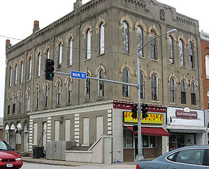
The Masonic Building stands on the public square in Osceola. Built in 1872, this Italianate building were used by Osceola Lodge No. 77 of the Ancient Free & Accepted Masons
, and the main floor was a bank and hardware store. This building has been placed on the Iowa Historic Preservation Alliance
’s Most Endangered list because of its poor repair and lack of preservation plan.
Nearly seven years ago the citizens of Osceola voted 'Yes' on a referendum that allowed a Casino boat to be established on their West Lake. The boat has since been taken over by Terrible's Herbst, and is now called Terrible's Lakeside Casino & Resort. A bright and gaudy 132 ft., $1 million, cowboy was erected on the sight to make the boat's presence known.
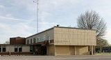
More recent developments include the building of a Wal-Mart department store which is located near Interstate 35 and Highway 34, and the opening of a new Dollar General Store which is located on Highway 69 where the old Boyt building once stood. This is part of a general economic upswing for Osceola that has accompanied the casino's advent.
of 2000, there were 4,659 people, 1,945 households, and 1,229 families residing in the city. The
population density
was 798.2 people per square mile (308.0/km²). There were 2,118 housing units at an average density of 362.9 per square mile (140.0/km²). The racial makeup of the city was 95.73% White, 0.11% African American, 0.19% Native American, 0.58% Asian, 0.06% Pacific Islander, 2.75% from other races
, and 0.58% from two or more races. Hispanic or Latino of any race were 6.25% of the population.
There were 1,945 households out of which 29.8% had children under the age of 18 living with them, 49.7% were married couples
living together, 10.1% had a female householder with no husband present, and 36.8% were non-families. 31.7% of all households were made up of individuals and 17.4% had someone living alone who was 65 years of age or older. The average household size was 2.36 and the average family size was 2.98.
In the city the population was spread out with 25.6% under the age of 18, 8.5% from 18 to 24, 25.6% from 25 to 44, 21.4% from 45 to 64, and 18.8% who were 65 years of age or older. The median age was 38 years. For every 100 females there were 89.9 males. For every 100 females age 18 and over, there were 85.1 males.
The median income for a household in the city was $32,701, and the median income for a family was $45,263. Males had a median income of $31,674 versus $21,684 for females. The per capita income
for the city was $17,244. About 5.2% of families and 7.6%
of the population were below the poverty line, including 13.3% of those under age 18 and 7.7% of those age 65 or over.
, the national passenger rail system, provides service to Osceola
, operating its California Zephyr
daily in both directions between Chicago
, Illinois
, and Emeryville, California
, across the bay from San Francisco. A bus connection is available from Osceola to Des Moines.
Clarke County, Iowa
-2010 census:The 2010 census recorded a population of 9,286 in the county, with a population density of . There were 4,086 housing units, of which 3,701 were occupied.-2000 census:...
, Iowa
Iowa
Iowa is a state located in the Midwestern United States, an area often referred to as the "American Heartland". It derives its name from the Ioway people, one of the many American Indian tribes that occupied the state at the time of European exploration. Iowa was a part of the French colony of New...
, United States
United States
The United States of America is a federal constitutional republic comprising fifty states and a federal district...
. The population was 4,659 at the 2000 census. It is the county seat
County seat
A county seat is an administrative center, or seat of government, for a county or civil parish. The term is primarily used in the United States....
of Clarke County
Clarke County, Iowa
-2010 census:The 2010 census recorded a population of 9,286 in the county, with a population density of . There were 4,086 housing units, of which 3,701 were occupied.-2000 census:...
.
Geography
Osceola is located at 41°2′3"N 93°46′6"W (41.034179, -93.768354), at the junction of Interstate 35Interstate 35
Interstate 35 is a north–south Interstate Highway in the central United States. I-35 stretches from Laredo, Texas, on the U.S.-Mexico border to Duluth, Minnesota, at Minnesota Highway 61 and 26th Avenue East. Many interstates used to have splits or spurs indicated with suffixed letters , but I-35...
and U.S. Routes 34
U.S. Route 34
U.S. Route 34 is an east–west United States highway that runs for 1,122 miles from north-central Colorado to the western suburbs of Chicago. Through Rocky Mountain National Park it is known as the Trail Ridge Road where it reaches 12,183 ft , making it the highest paved through highway in...
and 69
U.S. Route 69
U.S. Route 69 is a north–south United States highway. When it was first created, it was only long, but it has since been expanded into a Minnesota to Texas cross-country route. The highway's southern terminus is in Port Arthur, Texas at an intersection with State Highway 87...
. It lies 35 miles (56.3 km) north of the Missouri
Missouri
Missouri is a US state located in the Midwestern United States, bordered by Iowa, Illinois, Kentucky, Tennessee, Arkansas, Oklahoma, Kansas and Nebraska. With a 2010 population of 5,988,927, Missouri is the 18th most populous state in the nation and the fifth most populous in the Midwest. It...
border.
According to the United States Census Bureau
United States Census Bureau
The United States Census Bureau is the government agency that is responsible for the United States Census. It also gathers other national demographic and economic data...
, the city has a total area of 6 square miles (15.5 km²), of which, 5.8 square miles (15 km²) of it is land and 0.2 square mile (0.517997622 km²) of it (3.31%) is water.
History
The Masonic Building stands on the public square in Osceola. Built in 1872, this Italianate building were used by Osceola Lodge No. 77 of the Ancient Free & Accepted Masons
Freemasonry
Freemasonry is a fraternal organisation that arose from obscure origins in the late 16th to early 17th century. Freemasonry now exists in various forms all over the world, with a membership estimated at around six million, including approximately 150,000 under the jurisdictions of the Grand Lodge...
, and the main floor was a bank and hardware store. This building has been placed on the Iowa Historic Preservation Alliance
Iowa Historic Preservation Alliance
Preservation Iowa, formerly called the Iowa Historic Preservation Alliance , was founded in 1989 by members of the public concerned about the destruction of significant historic sites and buildings in the state of Iowa....
’s Most Endangered list because of its poor repair and lack of preservation plan.
Nearly seven years ago the citizens of Osceola voted 'Yes' on a referendum that allowed a Casino boat to be established on their West Lake. The boat has since been taken over by Terrible's Herbst, and is now called Terrible's Lakeside Casino & Resort. A bright and gaudy 132 ft., $1 million, cowboy was erected on the sight to make the boat's presence known.
More recent developments include the building of a Wal-Mart department store which is located near Interstate 35 and Highway 34, and the opening of a new Dollar General Store which is located on Highway 69 where the old Boyt building once stood. This is part of a general economic upswing for Osceola that has accompanied the casino's advent.
Demographics
As of the censusCensus
A census is the procedure of systematically acquiring and recording information about the members of a given population. It is a regularly occurring and official count of a particular population. The term is used mostly in connection with national population and housing censuses; other common...
of 2000, there were 4,659 people, 1,945 households, and 1,229 families residing in the city. The
population density
Population density
Population density is a measurement of population per unit area or unit volume. It is frequently applied to living organisms, and particularly to humans...
was 798.2 people per square mile (308.0/km²). There were 2,118 housing units at an average density of 362.9 per square mile (140.0/km²). The racial makeup of the city was 95.73% White, 0.11% African American, 0.19% Native American, 0.58% Asian, 0.06% Pacific Islander, 2.75% from other races
Race (United States Census)
Race and ethnicity in the United States Census, as defined by the Federal Office of Management and Budget and the United States Census Bureau, are self-identification data items in which residents choose the race or races with which they most closely identify, and indicate whether or not they are...
, and 0.58% from two or more races. Hispanic or Latino of any race were 6.25% of the population.
There were 1,945 households out of which 29.8% had children under the age of 18 living with them, 49.7% were married couples
Marriage
Marriage is a social union or legal contract between people that creates kinship. It is an institution in which interpersonal relationships, usually intimate and sexual, are acknowledged in a variety of ways, depending on the culture or subculture in which it is found...
living together, 10.1% had a female householder with no husband present, and 36.8% were non-families. 31.7% of all households were made up of individuals and 17.4% had someone living alone who was 65 years of age or older. The average household size was 2.36 and the average family size was 2.98.
In the city the population was spread out with 25.6% under the age of 18, 8.5% from 18 to 24, 25.6% from 25 to 44, 21.4% from 45 to 64, and 18.8% who were 65 years of age or older. The median age was 38 years. For every 100 females there were 89.9 males. For every 100 females age 18 and over, there were 85.1 males.
The median income for a household in the city was $32,701, and the median income for a family was $45,263. Males had a median income of $31,674 versus $21,684 for females. The per capita income
Per capita income
Per capita income or income per person is a measure of mean income within an economic aggregate, such as a country or city. It is calculated by taking a measure of all sources of income in the aggregate and dividing it by the total population...
for the city was $17,244. About 5.2% of families and 7.6%
of the population were below the poverty line, including 13.3% of those under age 18 and 7.7% of those age 65 or over.
Transportation
AmtrakAmtrak
The National Railroad Passenger Corporation, doing business as Amtrak , is a government-owned corporation that was organized on May 1, 1971, to provide intercity passenger train service in the United States. "Amtrak" is a portmanteau of the words "America" and "track". It is headquartered at Union...
, the national passenger rail system, provides service to Osceola
Osceola (Amtrak station)
The Osceola Amtrak station is a train station in Osceola, Iowa, United States served by Amtrak, the national railroad passenger system.Of the six Iowa stations served by Amtrak, Osceola was the busiest in FY2010, boarding or detraining an average of approximately 50 passengers daily. Among Amtrak...
, operating its California Zephyr
California Zephyr
The California Zephyr is a long passenger train route operated by Amtrak in the midwestern and western United States.It runs from Chicago, Illinois, in the east to Emeryville, California, in the west, passing through the states of Illinois, Iowa, Nebraska, Colorado, Utah, Nevada, and California...
daily in both directions between Chicago
Union Station (Chicago)
Union Station is a major train station that opened in 1925 in Chicago, replacing an earlier 1881 station. It is now the only intercity rail terminal in Chicago, as well as being the city's primary terminal for commuter trains. The station stands on the west side of the Chicago River between Adams...
, Illinois
Illinois
Illinois is the fifth-most populous state of the United States of America, and is often noted for being a microcosm of the entire country. With Chicago in the northeast, small industrial cities and great agricultural productivity in central and northern Illinois, and natural resources like coal,...
, and Emeryville, California
Emeryville, California
Emeryville is a small city located in Alameda County, California, in the United States. It is located in a corridor between the cities of Berkeley and Oakland, extending to the shore of San Francisco Bay. Its proximity to San Francisco, the Bay Bridge, the University of California, Berkeley, and...
, across the bay from San Francisco. A bus connection is available from Osceola to Des Moines.
External links
- City-Data Comprehensive Statistical Data and more about Osceola