
Tyringham, Massachusetts
Encyclopedia
Tyringham is a town
in Berkshire County
, Massachusetts
, United States. It is part of the Pittsfield
, Massachusetts
Metropolitan Statistical Area. The population was 327 at the 2010 census.
to the south. In 1750, Adonijah Bidwell
, a Yale
Divinity School graduate from the Hartford, Connecticut
region became the first minister of Township No. 1. When a meetinghouse was founded in the south, it led to a buildup in the north, and by 1767 the town was incorporated, and was named for Tyringham
, a village in Milton Keynes
, England. The town was home to a Shaker Village
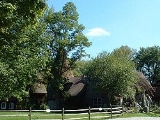
, called "Jerusalem," which lay just south of the town center. The town of Monterey was set off and incorporated as its own town in 1847. The town was the site of several small country estates for the wealthy, most of which are long gone, leaving Tyringham as a small, rural community.
 According to the United States Census Bureau
, the town has a total area of 18.9 square miles (49 km²), of which, 18.7 square miles (48.4 km²) of it is land and 0.2 square mile (0.517997622 km²) of it (1.22%) is water. The town is four sided, and is bordered by Lee
to the north, Becket
and Otis
to the east, Monterey
to the south, and Great Barrington
. Tyringham is located 16 miles south of Pittsfield
, 39 miles west-northwest of Springfield
, and 125 miles west of Boston.
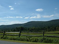
Tyringham is located in the Hop Brook Valley
in the Berkshire Hills
. To the northeast of the valley, Baldy Mountain rises to a large plateau which stretches into the neighboring towns, and includes Goose Pond. To the southwest of the valley, two mountain peaks - Mount Wilcot and Hunger Mountain - rise in a plateau in neighboring Monterey. The Appalachian Trail
passes through the town, winding down Sky Hill (a part of Mount Wilcot), then sweeps through the valley and over Baldy Mountain and towards Becket Mountain.
Tyringham is one of just fifteen towns in Massachusetts (and only two, along with Mount Washington
, in Berkshire County) which is not served by any state routes of any type. Interstate 90
(the Massachusetts Turnpike
) and U.S. Route 20
pass just north of the town's northeast corner, and Route 23 passes through neighboring Monterey to the south. The main road through town passes between this route to the south, and ends at Route 102
in Lee, just south of the point where it meets Route 20 at I-90 Exit 2. There are no rail or bus services in the town, with the nearest regional service for both being in Great Barrington. The nearest national air service can be reached at Bradley International Airport
in Connecticut
.
of 2000, there were 350 people, 133 households, and 98 families residing in the town. By population, the town ranks 30th out of 32 cities and towns in Berkshire County, and 345th out of the 351 in Massachusetts. The population density
was 18.7 people per square mile (7.2/km²), which ranks 28th in the county and 342nd in the Commonwealth. There were 265 housing units at an average density of 14.2 per square mile (5.5/km²). The racial makeup of the town was 95.43% White, 0.29% African American, 0.29% Native American, 2.57% Asian, and 1.43% from two or more races. Hispanic or Latino of any race were 0.29% of the population.
There were 133 households out of which 24.1% had children under the age of 18 living with them, 66.2% were married couples
living together, 6.0% had a female householder with no husband present, and 25.6% were non-families. 20.3% of all households were made up of individuals and 9.0% had someone living alone who was 65 years of age or older. The average household size was 2.56 and the average family size was 2.93.
In the town the population was spread out with 18.6% under the age of 18, 6.6% from 18 to 24, 18.9% from 25 to 44, 40.6% from 45 to 64, and 15.4% who were 65 years of age or older. The median age was 48 years. For every 100 females there were 101.1 males. For every 100 females age 18 and over, there were 103.6 males.
The median income for a household in the town was $60,250, and the median income for a family was $67,679. Males had a median income of $42,708 versus $31,250 for females. The per capita income
for the town was $35,503. None of the families and 3.5% of the population were living below the poverty line, including no under eighteens and none of those over 64.
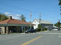 Tyringham uses the open town meeting
form of government, and is led by a board of selectmen
and an administrative assistant. The town has a police department, fire department and post office, as well as a library, which is adjacent to the town hall and is part of the regional library network. The nearest courthouses and hospital, Fairview Hospital, are located in Great Barrington.
On the state level, Tyringham is represented in the Massachusetts House of Representatives
by the Fourth Berkshire district, which covers southern Berkshire County, as well as the westernmost towns in Hampden County. In the Massachusetts Senate
, the town is represented by the Berkshire, Hampshire and Franklin district, which includes all of Berkshire County and western Hampshire and Franklin Counties. The town is patrolled by the First (Lee) Station of Barracks "B" of the Massachusetts State Police
.
On the national level, Tyringham is represented in the United States House of Representatives
as part of Massachusetts's 1st congressional district
, and has been represented by John Olver
of Amherst
since June 1991. Massachusetts is currently represented in the United States Senate
by senior Senator John Kerry
and junior Senator Scott Brown
The nearest community college
is the South County Center of Berkshire Community College
in Great Barrington. The nearest state college is Westfield State College
, and the nearest state university is the University of Massachusetts Amherst
. The nearest private college is Bard College at Simon's Rock.
New England town
The New England town is the basic unit of local government in each of the six New England states. Without a direct counterpart in most other U.S. states, New England towns are conceptually similar to civil townships in other states, but are incorporated, possessing powers like cities in other...
in Berkshire County
Berkshire County, Massachusetts
Berkshire County is a non-governmental county located on the western edge of the U.S. state of Massachusetts. As of the 2010 census, the population was 131,219. Its largest city and traditional county seat is Pittsfield...
, Massachusetts
Massachusetts
The Commonwealth of Massachusetts is a state in the New England region of the northeastern United States of America. It is bordered by Rhode Island and Connecticut to the south, New York to the west, and Vermont and New Hampshire to the north; at its east lies the Atlantic Ocean. As of the 2010...
, United States. It is part of the Pittsfield
Pittsfield, Massachusetts
Pittsfield is the largest city and the county seat of Berkshire County, Massachusetts, United States. It is the principal city of the Pittsfield, Massachusetts Metropolitan Statistical Area which encompasses all of Berkshire County. Its area code is 413. Its ZIP code is 01201...
, Massachusetts
Massachusetts
The Commonwealth of Massachusetts is a state in the New England region of the northeastern United States of America. It is bordered by Rhode Island and Connecticut to the south, New York to the west, and Vermont and New Hampshire to the north; at its east lies the Atlantic Ocean. As of the 2010...
Metropolitan Statistical Area. The population was 327 at the 2010 census.
History
Founded as Housatonic Township Number 1, the land which became Tyringham and Monterey was first settled in 1735. The two main villages were set up along two waterways, Hop Brook to the north and the Konkapot RiverKonkapot River
The Konkapot River is a river in southwestern Massachusetts and northern Connecticut. It is a tributary of the Housatonic River, not to be confused with the smaller Konkapot Brook in Stockbridge ....
to the south. In 1750, Adonijah Bidwell
Adonijah Bidwell
Adonijah Bidwell was the first minister of Housatonic Township No. 1. He played a large role in the formation and upkeep of the Monterey, Massachusetts militia. Classically educated at Yale, he participated in the victorious Louisbourg, Nova Scotia expedition during the third French and Indian...
, a Yale
YALE
RapidMiner, formerly YALE , is an environment for machine learning, data mining, text mining, predictive analytics, and business analytics. It is used for research, education, training, rapid prototyping, application development, and industrial applications...
Divinity School graduate from the Hartford, Connecticut
Hartford, Connecticut
Hartford is the capital of the U.S. state of Connecticut. The seat of Hartford County until Connecticut disbanded county government in 1960, it is the second most populous city on New England's largest river, the Connecticut River. As of the 2010 Census, Hartford's population was 124,775, making...
region became the first minister of Township No. 1. When a meetinghouse was founded in the south, it led to a buildup in the north, and by 1767 the town was incorporated, and was named for Tyringham
Tyringham
Tyringham is a village in the Borough of Milton Keynes and ceremonial county of Buckinghamshire, England. It is located about a mile and a half north of Newport Pagnell.The village name is an Old English language word, and means 'Tir's home'...
, a village in Milton Keynes
Milton Keynes (borough)
The Borough of Milton Keynes is a unitary authority and borough in south central England, at the northern tip of the South East England Region. For ceremonial purposes, it is in the county of Buckinghamshire...
, England. The town was home to a Shaker Village
Shakers
The United Society of Believers in Christ’s Second Appearing, known as the Shakers, is a religious sect originally thought to be a development of the Religious Society of Friends...
, called "Jerusalem," which lay just south of the town center. The town of Monterey was set off and incorporated as its own town in 1847. The town was the site of several small country estates for the wealthy, most of which are long gone, leaving Tyringham as a small, rural community.
Geography
United States Census Bureau
The United States Census Bureau is the government agency that is responsible for the United States Census. It also gathers other national demographic and economic data...
, the town has a total area of 18.9 square miles (49 km²), of which, 18.7 square miles (48.4 km²) of it is land and 0.2 square mile (0.517997622 km²) of it (1.22%) is water. The town is four sided, and is bordered by Lee
Lee, Massachusetts
Lee is a town in Berkshire County, Massachusetts, United States. It is part of the Pittsfield, Massachusetts, metropolitan statistical area. The population was 5,943 which was determined in the 2010 census. Lee, which includes the villages of South and East Lee, is part of the Berkshires resort...
to the north, Becket
Becket, Massachusetts
Becket is a town in Berkshire County, Massachusetts, United States. It is part of the Pittsfield, Massachusetts Metropolitan Statistical Area. The population was 1,779 at the 2010 census.- History :...
and Otis
Otis, Massachusetts
Otis is a town in Berkshire County, Massachusetts, United States. It is part of the Pittsfield, Massachusetts Metropolitan Statistical Area. The population was 1,365 at the 2000 census....
to the east, Monterey
Monterey, Massachusetts
Monterey is a town in Berkshire County, Massachusetts, United States. It is part of the Pittsfield, Massachusetts Metropolitan Statistical Area. The population was 934 at the 2000 census.- History :...
to the south, and Great Barrington
Great Barrington, Massachusetts
Great Barrington is a town in Berkshire County, Massachusetts, United States. It is part of the Pittsfield, Massachusetts Metropolitan Statistical Area. The population was 7,104 at the 2010 census. Both a summer resort and home to Ski Butternut, Great Barrington includes the villages of Van...
. Tyringham is located 16 miles south of Pittsfield
Pittsfield, Massachusetts
Pittsfield is the largest city and the county seat of Berkshire County, Massachusetts, United States. It is the principal city of the Pittsfield, Massachusetts Metropolitan Statistical Area which encompasses all of Berkshire County. Its area code is 413. Its ZIP code is 01201...
, 39 miles west-northwest of Springfield
Springfield, Massachusetts
Springfield is the most populous city in Western New England, and the seat of Hampden County, Massachusetts, United States. Springfield sits on the eastern bank of the Connecticut River near its confluence with three rivers; the western Westfield River, the eastern Chicopee River, and the eastern...
, and 125 miles west of Boston.
Tyringham is located in the Hop Brook Valley
Hop Brook Valley
The Hop Brook Valley is a valley in southeastern Berkshire County, Massachusetts. The valley lies predominantly in the town of Tyringham, Massachusetts, although a good portion of it is located in the neighboring town of Lee...
in the Berkshire Hills
The Berkshires
The Berkshires , is a highland geologic region located in the western parts of Massachusetts and Connecticut.Also referred to as the Berkshire Hills, Berkshire Mountains, and Berkshire Plateau, the region enjoys a vibrant tourism industry based on music, arts, and recreation.-Definition:The term...
. To the northeast of the valley, Baldy Mountain rises to a large plateau which stretches into the neighboring towns, and includes Goose Pond. To the southwest of the valley, two mountain peaks - Mount Wilcot and Hunger Mountain - rise in a plateau in neighboring Monterey. The Appalachian Trail
Appalachian Trail
The Appalachian National Scenic Trail, generally known as the Appalachian Trail or simply the AT, is a marked hiking trail in the eastern United States extending between Springer Mountain in Georgia and Mount Katahdin in Maine. It is approximately long...
passes through the town, winding down Sky Hill (a part of Mount Wilcot), then sweeps through the valley and over Baldy Mountain and towards Becket Mountain.
Tyringham is one of just fifteen towns in Massachusetts (and only two, along with Mount Washington
Mount Washington, Massachusetts
Mount Washington is a town in Berkshire County, Massachusetts, United States. It is part of the Pittsfield, Massachusetts Metropolitan Statistical Area. The population was 130 at the 2000 census, making it the smallest town in Berkshire County and, after Gosnold and Monroe, the third smallest in...
, in Berkshire County) which is not served by any state routes of any type. Interstate 90
Interstate 90
Interstate 90 is the longest Interstate Highway in the United States at . It is the northernmost coast-to-coast interstate, and parallels US 20 for the most part. Its western terminus is in Seattle, at Edgar Martinez Drive S. near Safeco Field and CenturyLink Field, and its eastern terminus is in...
(the Massachusetts Turnpike
Massachusetts Turnpike
The Massachusetts Turnpike is the easternmost stretch of Interstate 90. The Turnpike begins at the western border of Massachusetts in West Stockbridge connecting with the Berkshire Connector portion of the New York State Thruway...
) and U.S. Route 20
U.S. Route 20
U.S. Route 20 is an east–west United States highway. As the "0" in its route number implies, US 20 is a coast-to-coast route. Spanning , it is the longest road in the United States, and the route sparsely parallels Interstate 90...
pass just north of the town's northeast corner, and Route 23 passes through neighboring Monterey to the south. The main road through town passes between this route to the south, and ends at Route 102
Massachusetts Route 102
-Route description:Route 102 begins in West Stockbridge at the New York state line, connected to New York State Route 22 by New York State Reference Route 980D in Canaan, New York...
in Lee, just south of the point where it meets Route 20 at I-90 Exit 2. There are no rail or bus services in the town, with the nearest regional service for both being in Great Barrington. The nearest national air service can be reached at Bradley International Airport
Bradley International Airport
Bradley International Airport is a joint civil-military public airport located in Windsor Locks on the border with East Granby and Suffield, in Hartford County, Connecticut, United States. It is owned by the State of Connecticut....
in Connecticut
Connecticut
Connecticut is a state in the New England region of the northeastern United States. It is bordered by Rhode Island to the east, Massachusetts to the north, and the state of New York to the west and the south .Connecticut is named for the Connecticut River, the major U.S. river that approximately...
.
Demographics
As of the censusCensus
A census is the procedure of systematically acquiring and recording information about the members of a given population. It is a regularly occurring and official count of a particular population. The term is used mostly in connection with national population and housing censuses; other common...
of 2000, there were 350 people, 133 households, and 98 families residing in the town. By population, the town ranks 30th out of 32 cities and towns in Berkshire County, and 345th out of the 351 in Massachusetts. The population density
Population density
Population density is a measurement of population per unit area or unit volume. It is frequently applied to living organisms, and particularly to humans...
was 18.7 people per square mile (7.2/km²), which ranks 28th in the county and 342nd in the Commonwealth. There were 265 housing units at an average density of 14.2 per square mile (5.5/km²). The racial makeup of the town was 95.43% White, 0.29% African American, 0.29% Native American, 2.57% Asian, and 1.43% from two or more races. Hispanic or Latino of any race were 0.29% of the population.
There were 133 households out of which 24.1% had children under the age of 18 living with them, 66.2% were married couples
Marriage
Marriage is a social union or legal contract between people that creates kinship. It is an institution in which interpersonal relationships, usually intimate and sexual, are acknowledged in a variety of ways, depending on the culture or subculture in which it is found...
living together, 6.0% had a female householder with no husband present, and 25.6% were non-families. 20.3% of all households were made up of individuals and 9.0% had someone living alone who was 65 years of age or older. The average household size was 2.56 and the average family size was 2.93.
In the town the population was spread out with 18.6% under the age of 18, 6.6% from 18 to 24, 18.9% from 25 to 44, 40.6% from 45 to 64, and 15.4% who were 65 years of age or older. The median age was 48 years. For every 100 females there were 101.1 males. For every 100 females age 18 and over, there were 103.6 males.
The median income for a household in the town was $60,250, and the median income for a family was $67,679. Males had a median income of $42,708 versus $31,250 for females. The per capita income
Per capita income
Per capita income or income per person is a measure of mean income within an economic aggregate, such as a country or city. It is calculated by taking a measure of all sources of income in the aggregate and dividing it by the total population...
for the town was $35,503. None of the families and 3.5% of the population were living below the poverty line, including no under eighteens and none of those over 64.
Government
Open town meeting
An open town meeting is a form of town meeting in which all registered voters of a town may vote . This form of government is typical of smaller municipalities in the New England region of the United States....
form of government, and is led by a board of selectmen
Board of selectmen
The board of selectmen is commonly the executive arm of the government of New England towns in the United States. The board typically consists of three or five members, with or without staggered terms.-History:...
and an administrative assistant. The town has a police department, fire department and post office, as well as a library, which is adjacent to the town hall and is part of the regional library network. The nearest courthouses and hospital, Fairview Hospital, are located in Great Barrington.
On the state level, Tyringham is represented in the Massachusetts House of Representatives
Massachusetts House of Representatives
The Massachusetts House of Representatives is the lower house of the Massachusetts General Court, the state legislature of the Commonwealth of Massachusetts. It is composed of 160 members elected from single-member electoral districts across the Commonwealth. Representatives serve two-year terms...
by the Fourth Berkshire district, which covers southern Berkshire County, as well as the westernmost towns in Hampden County. In the Massachusetts Senate
Massachusetts Senate
The Massachusetts Senate is the upper house of the Massachusetts General Court, the bicameral state legislature of the Commonwealth of Massachusetts. The Senate comprises 40 elected members from 40 single-member senatorial districts in the state...
, the town is represented by the Berkshire, Hampshire and Franklin district, which includes all of Berkshire County and western Hampshire and Franklin Counties. The town is patrolled by the First (Lee) Station of Barracks "B" of the Massachusetts State Police
Massachusetts State Police
The Massachusetts State Police is an agency of the Commonwealth of Massachusetts' Executive Office of Public Safety and Security responsible for criminal law enforcement and traffic vehicle regulation across the state...
.
On the national level, Tyringham is represented in the United States House of Representatives
United States House of Representatives
The United States House of Representatives is one of the two Houses of the United States Congress, the bicameral legislature which also includes the Senate.The composition and powers of the House are established in Article One of the Constitution...
as part of Massachusetts's 1st congressional district
Massachusetts's 1st congressional district
Massachusetts's 1st congressional district is in western and central Massachusetts. The largest Massachusetts district in area, it covers about one-third of the state and is more rural than the rest. It has the state's highest point, Mount Greylock...
, and has been represented by John Olver
John Olver
John Walter Olver is the U.S. Representative for , serving since 1991. He is a member of the Democratic Party. Early in his career, he was a chemistry professor and served in both chambers of the Massachusetts General Court....
of Amherst
Amherst, Massachusetts
Amherst is a town in Hampshire County, Massachusetts, United States in the Connecticut River valley. As of the 2010 census, the population was 37,819, making it the largest community in Hampshire County . The town is home to Amherst College, Hampshire College, and the University of Massachusetts...
since June 1991. Massachusetts is currently represented in the United States Senate
United States Senate
The United States Senate is the upper house of the bicameral legislature of the United States, and together with the United States House of Representatives comprises the United States Congress. The composition and powers of the Senate are established in Article One of the U.S. Constitution. Each...
by senior Senator John Kerry
John Kerry
John Forbes Kerry is the senior United States Senator from Massachusetts, the 10th most senior U.S. Senator and chairman of the Senate Foreign Relations Committee. He was the presidential nominee of the Democratic Party in the 2004 presidential election, but lost to former President George W...
and junior Senator Scott Brown
Scott Brown
Scott Brown is a United States senator.Scott Brown may also refer to:-Sportsmen:*Scott Brown , American college football coach of Kentucky State...
Education
Tyringham students are sent to Lee Public Schools by arrangement with that town. Lee Elementary School serves students from pre-kindergarten through sixth grades, and the Lee Middle and High School serves students from seventh through twelfth grades. Additionally, neighboring Lee is home to Saint Mary's School, a parochial school which serves students through eighth grade. Other private schools can be found in Great Barrington and other surrounding towns.The nearest community college
Community college
A community college is a type of educational institution. The term can have different meanings in different countries.-Australia:Community colleges carry on the tradition of adult education, which was established in Australia around mid 19th century when evening classes were held to help adults...
is the South County Center of Berkshire Community College
Berkshire Community College
Berkshire Community College is a two-year community college in Berkshire County, Massachusetts, United States. It offers associate degrees as well as a transfer program for students to earn credits for transfer to other colleges...
in Great Barrington. The nearest state college is Westfield State College
Westfield State College
Westfield State University is a comprehensive, coeducational, four-year public university in Westfield, Massachusetts. It was founded in 1838 by noted educator and social reformer Horace Mann as the first public co-educational college in America without barrier to race, gender and economic class...
, and the nearest state university is the University of Massachusetts Amherst
University of Massachusetts Amherst
The University of Massachusetts Amherst is a public research and land-grant university in Amherst, Massachusetts, United States and the flagship of the University of Massachusetts system...
. The nearest private college is Bard College at Simon's Rock.
Points of interest
- Tyringham Shaker Settlement Historic DistrictTyringham Shaker Settlement Historic DistrictTyringham Shaker Settlement Historic District is a historic Shaker village on Jerusalem Road in Tyringham, Massachusetts.-See also:*Tyringham, Massachusetts*List of Registered Historic Places in Berkshire County, Massachusetts*Shakers...
- Santarella, home of sculptor Henry Hudson KitsonHenry Hudson KitsonSir Henry Hudson Kitson, often known as H. H. Kitson, American sculptor, born in Huddersfield, England on April 9, 1865 and died at Tyringham, Massachusetts, on June 26, 1947...