
.gif)
Typhoon Rammasun (2008)
Encyclopedia
Typhoon Rammasun was recognized as the second typhoon of the 2008 Pacific typhoon season
by the Japan Meteorological Agency
(JMA) and the Philippine Atmospheric, Geophysical and Astronomical Services Administration
(PAGASA). Rammasun was also recognised as the third tropical storm, the second typhoon and the first super typhoon of the 2008 Pacific typhoon season
by the Joint Typhoon Warning Center
(JTWC).
Rammasun formed on May 5 as a tropical disturbance, the next day the Joint Typhoon Warning Center
issued a tropical cyclone formation alert
on the developing disturbance. On May 7 both the JTWC and the Japan Meteorological Agency
designated the disturbance as a tropical depression, while PAGASA named the depression Butchoy. Later that day both the JMA and the JTWC upgraded the depression to a tropical storm with the JMA naming the storm Rammasun. On May 9 both the JTWC and the JMA upgraded Rammasun to a typhoon. The next day the JMA and the JTWC reported that Rammasun had reached its peak winds of 195 km/h (120 mph) and 250 km/h (155 mph) respectively, which made Rammasun a Category 4 super typhoon on the Saffir-Simpson Hurricane Scale
. After reaching its peak intensity, Rammasun weakened and was downgraded to severe tropical storm on May 12, before the JTWC declared it extratropical
and issued their final advisory. The JMA did not issue their final advisory until several hours later. Within Japan an estimated 10 hectares (24.7 acres) of farmland were damaged. In all, the typhoon killed four people, injured 40 others and caused $9.6 million (2008 USD) worth of damage in both the Philippines and Japan.
formed in the Pacific Ocean
to the southeast of Yap
. The next day, the Joint Typhoon Warning Center
(JTWC) upgraded the area of low pressure to a tropical disturbance and assessed the disturbances chances of forming in to a significant tropical cyclone within 24 hours as poor. This was because the developing low level circulation center
was weak. Early on May 6, the JTWC upgraded the disturbances chances of forming into a tropical cyclone within 24 hours to "fair", as the low level circulation center had consolidated further. A tropical cyclone formation alert
was then issued later that day, by the JTWC who upgraded the disturbance's chances of becoming a tropical cyclone by the next day as good.
Early the next day both the Japan Meteorological Agency
(JMA) and the Philippine Atmospheric, Geophysical and Astronomical Services Administration
(PAGASA) designated the tropical disturbance as a tropical depression with PAGASA assigning the local name of Butchoy to the depression. At this time the depression was located 790 km, (490 miles), to the east of Mindanao
in the Philippines. Later that morning the JMA started to issue full advisories on the tropical depression as forecasts showed that the depression could become a tropical storm within 24 hours. The JTWC then designated the depression as Tropical Depression 02W. Later that day both the JTWC and the JMA reported that the depression intensified into a tropical storm, with the JMA assigning the name Rammasun to the storm.
Rammasun continued to intensify and was designated as a severe tropical storm late on May 8. The next day both the JMA and the JTWC reported that Rammasun had intensified in to a typhoon. Later that day the JTWC reported that the typhoon had rapidly intensified
within the last six hours and had become a Category 3 typhoon on the Saffir Simpson Hurricane Scale. At the same time the JMA were reporting that Rammasun had winds of 150 km/h (90 mph). The typhoon then continued to intensify quickly with the JMA reporting that Rammasun had winds of 160 km/h (100 mph), the JTWC then reported that Rammasun had become a Category 4 typhoon with winds of 225 km/h (140 mph). Later that day both the JMA and the JTWC reported that the typhoon had reached its peak winds. The JMA reported peak winds of 195 km/h (120 mph) whilst the JTWC reported that Rammasun had peak winds of 250 km/h (155 mph), making it a category 4 super typhoon. Typhoon Rammasun's minimum pressure was officially estimated at 915 hPa which tied with Intense Tropical Cyclone Hondo as second strongest storm of 2008.
The JTWC kept Rammasun as a super typhoon until early on May 11, when they reported that the typhoon had weakened into a category four typhoon, while the JMA were reporting that the typhoon had wind speeds of 175 km/h (110 mph). Later that day both agencies reported that the typhoon had weakened even further, with the JMA reporting that Rammasun had winds of 160 km/h (100 mph), while the JTWC reported that Rammasun had weakened in to a Category 3 typhoon. The JTWC then reported within their next advisory that Rammasun had weakened in to a Category 2 typhoon whilst the JMA reported that the typhoon had winds of 140 km/h (90 mph). The next day as the Typhoon moved out of PAGASA's area of responsibility
Rammasun was downgraded to a Category 1 typhoon by the JTWC. Later that day the JMA downgraded Rammasun to a Severe Tropical Storm whilst the JTWC downgraded it to an extratropical cyclone
and released their final advisory on the system. The JMA continued to issue advisories on severe tropical storm Rammasun until early the next day when they downgraded it to an extratropical low.
 The name "Rammasun" was one of the 10 original names submitted by Thailand to the ESCAP/WMO Typhoon Committee for use from January 1, 2000. Rammasun is the Thai
god for thunder
. The name was last used in the 2002 Pacific typhoon season
. The Philippine Atmospheric, Geophysical and Astronomical Services Administration
(PAGASA) also assigned the local name of "Butchoy" to Rammasun; the name "Butchoy" was last used by PAGASA to name a tropical depression in the Philippines in 2004 to name Tropical Storm 02W.
Within the Philippines
, PAGASA issued no public storm warning signals, as the storm was too far away from the country to prompt the issuance of such advisories. However, they did warn that the cyclone was expected to enhance the southwest monsoon and bring rain over Central and Southern Luzon, Visayas and Mindanao.
of Rammasun triggered flooding and mudslides in the Philippines. Strong winds also downed numerous trees, one of which, measured at 60 centimetres (2 ft) in diameter, fell on three forest guards, killing two and critically injuring the other. In Jaro, Iloilo City
, a swollen river overflowed its banks, inundating the district. Local reports stated that water in the area was waist-deep in places. In Cauayan
, a 15-year-old girl drowned after being washed away while crossing a bridge. Flooding in Hinoba-an, Negros Occidental
destroyed six homes and damaged 24 others. An estimated 3,153 families were affected by the storm in the Philippines. A strong extratropical storm from the "tail" of the former typhoon struck the Philippines after Rammasun had become extratropical. The associated winds caused severe damage to buildings, and numerous trees were uprooted. The damage may have been due to a possible tornado
, although this possibility is not confirmed. At least 40 people were injured and damage totaled to PHP
61 million ($1.2 million USD
).
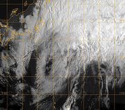
issued warnings for the Tokyo
area as Rammasun was forecast to make landfall near the city. As Rammasun became extratropical, the storm brushed the Japanese coastline on May 13, producing winds gusting up to 85 km/h (50 mph) and high waves for several hours. An estimated 10 hectare
s (24.7 acre
s) of farmland were damaged. Damage from the storm amounted to ¥
770 million ($8.4 million 2008 USD
) in agricultural losses.
2008 Pacific typhoon season
The 2008 Pacific typhoon season has no official bounds; it runs year-round in 2008, but most tropical cyclones tend to form in the northwestern Pacific Ocean between May and November...
by the Japan Meteorological Agency
Japan Meteorological Agency
The or JMA, is the Japanese government's weather service. Charged with gathering and reporting weather data and forecasts in Japan, it is a semi-autonomous part of the Ministry of Land, Infrastructure and Transport...
(JMA) and the Philippine Atmospheric, Geophysical and Astronomical Services Administration
Philippine Atmospheric, Geophysical and Astronomical Services Administration
The Philippine Atmospheric, Geophysical and Astronomical Services Administration is a Philippine national institution dedicated to provide flood and typhoon warnings, public weather forecasts and advisories, meteorological, astronomical, climatological, and other specialized information and...
(PAGASA). Rammasun was also recognised as the third tropical storm, the second typhoon and the first super typhoon of the 2008 Pacific typhoon season
2008 Pacific typhoon season
The 2008 Pacific typhoon season has no official bounds; it runs year-round in 2008, but most tropical cyclones tend to form in the northwestern Pacific Ocean between May and November...
by the Joint Typhoon Warning Center
Joint Typhoon Warning Center
The Joint Typhoon Warning Center is a joint United States Navy – United States Air Force task force located at the Naval Maritime Forecast Center in Pearl Harbor, Hawaii...
(JTWC).
Rammasun formed on May 5 as a tropical disturbance, the next day the Joint Typhoon Warning Center
Joint Typhoon Warning Center
The Joint Typhoon Warning Center is a joint United States Navy – United States Air Force task force located at the Naval Maritime Forecast Center in Pearl Harbor, Hawaii...
issued a tropical cyclone formation alert
Tropical Cyclone Formation Alert
A Tropical Cyclone Formation Alert is a bulletin released by the U.S. Navy-operated Joint Typhoon Warning Center in Honolulu, Hawaii or the Naval Maritime Forecast Center in Norfolk, Virginia, warning of the possibility of a tropical cyclone forming from a tropical disturbance that has been...
on the developing disturbance. On May 7 both the JTWC and the Japan Meteorological Agency
Japan Meteorological Agency
The or JMA, is the Japanese government's weather service. Charged with gathering and reporting weather data and forecasts in Japan, it is a semi-autonomous part of the Ministry of Land, Infrastructure and Transport...
designated the disturbance as a tropical depression, while PAGASA named the depression Butchoy. Later that day both the JMA and the JTWC upgraded the depression to a tropical storm with the JMA naming the storm Rammasun. On May 9 both the JTWC and the JMA upgraded Rammasun to a typhoon. The next day the JMA and the JTWC reported that Rammasun had reached its peak winds of 195 km/h (120 mph) and 250 km/h (155 mph) respectively, which made Rammasun a Category 4 super typhoon on the Saffir-Simpson Hurricane Scale
Saffir-Simpson Hurricane Scale
The Saffir–Simpson Hurricane Scale , or the Saffir–Simpson Hurricane Wind Scale , classifies hurricanes — Western Hemisphere tropical cyclones that exceed the intensities of tropical depressions and tropical storms — into five categories distinguished by the intensities of their sustained winds...
. After reaching its peak intensity, Rammasun weakened and was downgraded to severe tropical storm on May 12, before the JTWC declared it extratropical
Extratropical cyclone
Extratropical cyclones, sometimes called mid-latitude cyclones or wave cyclones, are a group of cyclones defined as synoptic scale low pressure weather systems that occur in the middle latitudes of the Earth having neither tropical nor polar characteristics, and are connected with fronts and...
and issued their final advisory. The JMA did not issue their final advisory until several hours later. Within Japan an estimated 10 hectares (24.7 acres) of farmland were damaged. In all, the typhoon killed four people, injured 40 others and caused $9.6 million (2008 USD) worth of damage in both the Philippines and Japan.
Meteorological history
On May 4, 2008, an area of low pressureLow pressure area
A low-pressure area, or "low", is a region where the atmospheric pressure at sea level is below that of surrounding locations. Low-pressure systems form under areas of wind divergence which occur in upper levels of the troposphere. The formation process of a low-pressure area is known as...
formed in the Pacific Ocean
Pacific Ocean
The Pacific Ocean is the largest of the Earth's oceanic divisions. It extends from the Arctic in the north to the Southern Ocean in the south, bounded by Asia and Australia in the west, and the Americas in the east.At 165.2 million square kilometres in area, this largest division of the World...
to the southeast of Yap
Yap
Yap, also known as Wa'ab by locals, is an island in the Caroline Islands of the western Pacific Ocean. It is a state of the Federated States of Micronesia. Yap's indigenous cultures and traditions are still strong compared to other neighboring islands. The island of Yap actually consists of four...
. The next day, the Joint Typhoon Warning Center
Joint Typhoon Warning Center
The Joint Typhoon Warning Center is a joint United States Navy – United States Air Force task force located at the Naval Maritime Forecast Center in Pearl Harbor, Hawaii...
(JTWC) upgraded the area of low pressure to a tropical disturbance and assessed the disturbances chances of forming in to a significant tropical cyclone within 24 hours as poor. This was because the developing low level circulation center
Tropical cyclone
A tropical cyclone is a storm system characterized by a large low-pressure center and numerous thunderstorms that produce strong winds and heavy rain. Tropical cyclones strengthen when water evaporated from the ocean is released as the saturated air rises, resulting in condensation of water vapor...
was weak. Early on May 6, the JTWC upgraded the disturbances chances of forming into a tropical cyclone within 24 hours to "fair", as the low level circulation center had consolidated further. A tropical cyclone formation alert
Tropical Cyclone Formation Alert
A Tropical Cyclone Formation Alert is a bulletin released by the U.S. Navy-operated Joint Typhoon Warning Center in Honolulu, Hawaii or the Naval Maritime Forecast Center in Norfolk, Virginia, warning of the possibility of a tropical cyclone forming from a tropical disturbance that has been...
was then issued later that day, by the JTWC who upgraded the disturbance's chances of becoming a tropical cyclone by the next day as good.
Early the next day both the Japan Meteorological Agency
Japan Meteorological Agency
The or JMA, is the Japanese government's weather service. Charged with gathering and reporting weather data and forecasts in Japan, it is a semi-autonomous part of the Ministry of Land, Infrastructure and Transport...
(JMA) and the Philippine Atmospheric, Geophysical and Astronomical Services Administration
Philippine Atmospheric, Geophysical and Astronomical Services Administration
The Philippine Atmospheric, Geophysical and Astronomical Services Administration is a Philippine national institution dedicated to provide flood and typhoon warnings, public weather forecasts and advisories, meteorological, astronomical, climatological, and other specialized information and...
(PAGASA) designated the tropical disturbance as a tropical depression with PAGASA assigning the local name of Butchoy to the depression. At this time the depression was located 790 km, (490 miles), to the east of Mindanao
Mindanao
Mindanao is the second largest and easternmost island in the Philippines. It is also the name of one of the three island groups in the country, which consists of the island of Mindanao and smaller surrounding islands. The other two are Luzon and the Visayas. The island of Mindanao is called The...
in the Philippines. Later that morning the JMA started to issue full advisories on the tropical depression as forecasts showed that the depression could become a tropical storm within 24 hours. The JTWC then designated the depression as Tropical Depression 02W. Later that day both the JTWC and the JMA reported that the depression intensified into a tropical storm, with the JMA assigning the name Rammasun to the storm.
Rammasun continued to intensify and was designated as a severe tropical storm late on May 8. The next day both the JMA and the JTWC reported that Rammasun had intensified in to a typhoon. Later that day the JTWC reported that the typhoon had rapidly intensified
Rapid deepening
Rapid deepening, also known as rapid intensification, is a meteorological condition that occurs when the minimum sea-level atmospheric pressure of a tropical cyclone decreases drastically in a short period of time. The National Weather Service describes rapid deepening as a decrease of...
within the last six hours and had become a Category 3 typhoon on the Saffir Simpson Hurricane Scale. At the same time the JMA were reporting that Rammasun had winds of 150 km/h (90 mph). The typhoon then continued to intensify quickly with the JMA reporting that Rammasun had winds of 160 km/h (100 mph), the JTWC then reported that Rammasun had become a Category 4 typhoon with winds of 225 km/h (140 mph). Later that day both the JMA and the JTWC reported that the typhoon had reached its peak winds. The JMA reported peak winds of 195 km/h (120 mph) whilst the JTWC reported that Rammasun had peak winds of 250 km/h (155 mph), making it a category 4 super typhoon. Typhoon Rammasun's minimum pressure was officially estimated at 915 hPa which tied with Intense Tropical Cyclone Hondo as second strongest storm of 2008.
The JTWC kept Rammasun as a super typhoon until early on May 11, when they reported that the typhoon had weakened into a category four typhoon, while the JMA were reporting that the typhoon had wind speeds of 175 km/h (110 mph). Later that day both agencies reported that the typhoon had weakened even further, with the JMA reporting that Rammasun had winds of 160 km/h (100 mph), while the JTWC reported that Rammasun had weakened in to a Category 3 typhoon. The JTWC then reported within their next advisory that Rammasun had weakened in to a Category 2 typhoon whilst the JMA reported that the typhoon had winds of 140 km/h (90 mph). The next day as the Typhoon moved out of PAGASA's area of responsibility
Philippine Atmospheric, Geophysical and Astronomical Services Administration
The Philippine Atmospheric, Geophysical and Astronomical Services Administration is a Philippine national institution dedicated to provide flood and typhoon warnings, public weather forecasts and advisories, meteorological, astronomical, climatological, and other specialized information and...
Rammasun was downgraded to a Category 1 typhoon by the JTWC. Later that day the JMA downgraded Rammasun to a Severe Tropical Storm whilst the JTWC downgraded it to an extratropical cyclone
Extratropical cyclone
Extratropical cyclones, sometimes called mid-latitude cyclones or wave cyclones, are a group of cyclones defined as synoptic scale low pressure weather systems that occur in the middle latitudes of the Earth having neither tropical nor polar characteristics, and are connected with fronts and...
and released their final advisory on the system. The JMA continued to issue advisories on severe tropical storm Rammasun until early the next day when they downgraded it to an extratropical low.
Naming, preparations and impact
Thai language
Thai , also known as Central Thai and Siamese, is the national and official language of Thailand and the native language of the Thai people, Thailand's dominant ethnic group. Thai is a member of the Tai group of the Tai–Kadai language family. Historical linguists have been unable to definitively...
god for thunder
Thunder
Thunder is the sound made by lightning. Depending on the nature of the lightning and distance of the listener, thunder can range from a sharp, loud crack to a long, low rumble . The sudden increase in pressure and temperature from lightning produces rapid expansion of the air surrounding and within...
. The name was last used in the 2002 Pacific typhoon season
2002 Pacific typhoon season
A Tropical Cyclone Formation Alert was issued on July 19 for a Tropical Disturbance that was located east of the international Date Line. The Next day the Disturbance crossed the international date line and was classified as a Tropical Depression by the JMA. The JMA then upgraded the depression to...
. The Philippine Atmospheric, Geophysical and Astronomical Services Administration
Philippine Atmospheric, Geophysical and Astronomical Services Administration
The Philippine Atmospheric, Geophysical and Astronomical Services Administration is a Philippine national institution dedicated to provide flood and typhoon warnings, public weather forecasts and advisories, meteorological, astronomical, climatological, and other specialized information and...
(PAGASA) also assigned the local name of "Butchoy" to Rammasun; the name "Butchoy" was last used by PAGASA to name a tropical depression in the Philippines in 2004 to name Tropical Storm 02W.
Within the Philippines
Philippines
The Philippines , officially known as the Republic of the Philippines , is a country in Southeast Asia in the western Pacific Ocean. To its north across the Luzon Strait lies Taiwan. West across the South China Sea sits Vietnam...
, PAGASA issued no public storm warning signals, as the storm was too far away from the country to prompt the issuance of such advisories. However, they did warn that the cyclone was expected to enhance the southwest monsoon and bring rain over Central and Southern Luzon, Visayas and Mindanao.
Philippines
On May 12, a father of two drowned in rough seas produced by Rammasun after saving his children. Later that day, a boat carrying 17 people capsized due to rough seas produced by the typhoon. All of the passengers were rescued the following day by the Philippine Coast Guard. Heavy rains from the outer bandsRainband
A rainband is a cloud and precipitation structure associated with an area of rainfall which is significantly elongated. Rainbands can be stratiform or convective, and are generated by differences in temperature. When noted on weather radar imagery, this precipitation elongation is referred to as...
of Rammasun triggered flooding and mudslides in the Philippines. Strong winds also downed numerous trees, one of which, measured at 60 centimetres (2 ft) in diameter, fell on three forest guards, killing two and critically injuring the other. In Jaro, Iloilo City
Jaro, Iloilo City
Jaro is one of the six districts of Iloilo City, in the Philippine province of Iloilo, on the island of Panay, in the Western Visayas.It is the seat of the Catholic Archdiocese of Jaro, that covers the whole Western Visayan region. -History:...
, a swollen river overflowed its banks, inundating the district. Local reports stated that water in the area was waist-deep in places. In Cauayan
Cauayan
Cauayan can refer to:* Cauayan City, Isabela province, Philippines* Cauayan, Negros Occidental, Philippines...
, a 15-year-old girl drowned after being washed away while crossing a bridge. Flooding in Hinoba-an, Negros Occidental
Hinoba-an, Negros Occidental
Hinoba-an is a municipality in the province of Negros Occidental, Philippines. It is the southernmost town of the province. It is bounded on the north by Sipalay City and Candoni; on the south by Basay, Negros Oriental; on the east by the town of Ilog; and on the west by the Sulu Sea...
destroyed six homes and damaged 24 others. An estimated 3,153 families were affected by the storm in the Philippines. A strong extratropical storm from the "tail" of the former typhoon struck the Philippines after Rammasun had become extratropical. The associated winds caused severe damage to buildings, and numerous trees were uprooted. The damage may have been due to a possible tornado
Tornado
A tornado is a violent, dangerous, rotating column of air that is in contact with both the surface of the earth and a cumulonimbus cloud or, in rare cases, the base of a cumulus cloud. They are often referred to as a twister or a cyclone, although the word cyclone is used in meteorology in a wider...
, although this possibility is not confirmed. At least 40 people were injured and damage totaled to PHP
Philippine peso
The peso is the currency of the Philippines. It is subdivided into 100 centavos . Before 1967, the language used on the banknotes and coins was English and so "peso" was the name used...
61 million ($1.2 million USD
United States dollar
The United States dollar , also referred to as the American dollar, is the official currency of the United States of America. It is divided into 100 smaller units called cents or pennies....
).
Japan
On May 12, the Japan Meteorological AgencyJapan Meteorological Agency
The or JMA, is the Japanese government's weather service. Charged with gathering and reporting weather data and forecasts in Japan, it is a semi-autonomous part of the Ministry of Land, Infrastructure and Transport...
issued warnings for the Tokyo
Tokyo
, ; officially , is one of the 47 prefectures of Japan. Tokyo is the capital of Japan, the center of the Greater Tokyo Area, and the largest metropolitan area of Japan. It is the seat of the Japanese government and the Imperial Palace, and the home of the Japanese Imperial Family...
area as Rammasun was forecast to make landfall near the city. As Rammasun became extratropical, the storm brushed the Japanese coastline on May 13, producing winds gusting up to 85 km/h (50 mph) and high waves for several hours. An estimated 10 hectare
Hectare
The hectare is a metric unit of area defined as 10,000 square metres , and primarily used in the measurement of land. In 1795, when the metric system was introduced, the are was defined as being 100 square metres and the hectare was thus 100 ares or 1/100 km2...
s (24.7 acre
Acre
The acre is a unit of area in a number of different systems, including the imperial and U.S. customary systems. The most commonly used acres today are the international acre and, in the United States, the survey acre. The most common use of the acre is to measure tracts of land.The acre is related...
s) of farmland were damaged. Damage from the storm amounted to ¥
Japanese yen
The is the official currency of Japan. It is the third most traded currency in the foreign exchange market after the United States dollar and the euro. It is also widely used as a reserve currency after the U.S. dollar, the euro and the pound sterling...
770 million ($8.4 million 2008 USD
United States dollar
The United States dollar , also referred to as the American dollar, is the official currency of the United States of America. It is divided into 100 smaller units called cents or pennies....
) in agricultural losses.
See also
- List of Pacific typhoon seasons
- 2008 Pacific typhoon season2008 Pacific typhoon seasonThe 2008 Pacific typhoon season has no official bounds; it runs year-round in 2008, but most tropical cyclones tend to form in the northwestern Pacific Ocean between May and November...
- Typhoons in the PhilippinesTyphoons in the PhilippinesTyphoons in the Philippines refer in general to tropical cyclones that enter the Philippine area of responsibility and affect the Philippines. Locally they are called bagyo...
- Timeline of the 2008 Pacific typhoon seasonTimeline of the 2008 Pacific typhoon seasonThis timeline documents all the storm formations, strengthening, weakening, landfalls, extratropical transitions, as well as dissipation during the 2008 Pacific typhoon season. The 2008 Pacific typhoon season officially started on January 1, 2008 and ended on January 1, 2009. The first tropical...