

Typhoon Kompasu (2010)
Encyclopedia
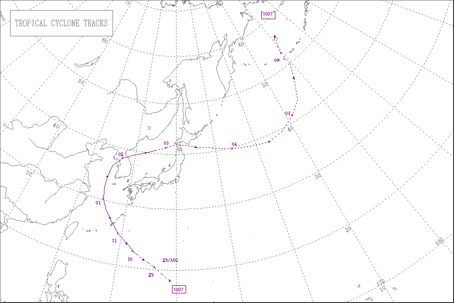
Typhoon Kompasu was the Category 3 typhoon
that moved along Okinawa, Japan
and west coast of the Korean Peninsula
before striking the Seoul Metropolitan Area in early-September 2010. It was the first significant system to directly strike the Seoul Metropolitan since Typhoon Prapiroon in 2000 and the strongest typhoon to directly impact the area since Typhoon Janis in 1995.
on August 25, as a tropical disturbance developing out of a surface trough of low pressure that was located near Chuuk State. Over the next couple of days, the disturbance moved towards the northwest as it moved under the steering influence of a deep subtropical ridge of high pressure. During August 28, the disturbance developed a low level circulation which rapidly consolidated throughout that day. This led to the Japan Meteorological Agency and the JTWC designating it as Tropical Depression 08W during that day before the JTWC reported that the depression had intensified into a tropical storm. During the next day the PAGASA reported that the Tropical Depression had moved into their area of responsibility and subsequently named it Tropical Storm Glenda. Later that day the JMA also reported that Glenda had intensified into tropical storm and named it as Kompasu.
Early on August 30, the JTWC reported that Kompasu had developed an eye feature and had intensified into a typhoon. However the JMA did not follow suit until 1800 UTC, that day after the JTWC had assessed the intensity of Kompasu at 165 km/h (100 mph). During the next day as Kompasu passed over Okinawa both the JTWC and the JMA reported that Kompasu had peaked with windspeeds of 185 km/h, (115 mph) and 150 km/h, (90 mph) respectively.
The Japan Meteorological Agency's Regional Specialized Meteorological Center
in Tokyo, Japan uses the Typhoon Committees Tropical Cyclone Intensity Scale which is based on 10-minute sustained winds for its tropical cyclone tracking information, while the Joint Typhoon Warning Center
uses 1-minute sustained winds. The conversion factor between the two is 1.14. The JMA's peak intensity for Kompasu was 150 km/h, (90 mph) 10-minute sustained, or 170 km/h, (105 mph) 1-minute sustained. The JTWC's peak intensity for Kompasu was 185 km/h, (115 mph) 1-minute sustained, or 165 km/h (100 mph) 10-minute sustained.
base in Okinawa began preparing for what was then Tropical Storm 08W. Tropical Cyclone Condition of Readiness
(TCCOR) level three was issued the following morning. By August 30, forecasts showed that a strengthening storm would strike the area, possibly bringing winds in excess of 130 km/h (80.8 mph). Following this, the TCCOR level was increased to two. For the first time in over three years, TCCOR level one was declared on August 31. Military personnel and residents across the island were urged to complete their preparations and remain indoors for the duration of the typhoon. During the storm's passage on August 31, the highest warning level, TCCOR One-E (emergency) was declared. Following Kompasu's passage, the emergency warning was changed to recovery as conditions improved.
Throughout Okinawa, Kompasu brought strong winds and heavy rains, leaving an estimated 32,000 residences without power. The highest rainfall total was measured in Motobu
at 4.96 in (126 mm). Winds in excess of 150 km/h (93.2 mph) felled a 300-year-old tree. The 17 m (55.8 ft) Sion Pine Tree was the last of its kind on the island and was once the symbol of the northern Okinawa Region. The Okuma Recreation Facility sustained substantial damage and was closed to the public for at least a week. According to United States Air Force
captain Adam Vaccarezza, concrete towers fell during the storm. Although Kompasu was a strong typhoon when it passed over Okinawa, no loss of life took place; however, five people were injured. Some homes sustained roof damage across the region, prompting a few evacuations. Additionally, Kompasu resulted in the cancellation of 432 flights to and from the island chain, stranding 57,126 people.
City, Zhejiang
issued an orange typhoon warning signal, and estimated that at midnight on the same day, the wind from the sea along the coast of Zhoushan would gradually intensify to 8-10 grade
, and from the morning of 1 September will continue to increase from 10-12, and near the sea winds would exceed 12 grade. Zhoushan City schools delayed the beginning of the school term, to ensure the safety of students and teachers.
In Jiangsu
Province, at 16:00 CST on 31 August, the Jiangsu Province Meteorological Observatory issued a blue typhoon warning signal, and within the next 24 hours, Nantong
, Yancheng
, Lianyungang
and other coastal areas received sea wind gusts of a 9-10 grade average.
On the same day at 17:00 CST, the Shanghai Meteorological Observatory issued a blue typhoon warning signal for the Shanghai
region, and expected that after midnight, winds would reach 6-8 grade, and that along the Yangtze River
estuary, coastal winds would reach an intensity of 8-10 grade. On September 1, the Shanghai Municipal Government announced that schools would be closed on that day, whilst at Shanghai Honqiao and Pudong airports, flight times were adjusted for passengers' safety.
In Shandong
Province, on 31 August at 17:00 CST, the Shandong Province Meteorological observatory at Rizhao
City issued a blue typhoon warning signal, and expected offshore wind intensities to reach 7-9 grade.
($1.34 million USD). Due to the relatively fast movement of the storm, much of the damage was sustained by intense winds which were recorded up to 188 km/h (116.8 mph), the sixth highest wind speed ever recorded in the country. The heaviest rains fell in Ganghwa, where 131.5 mm (5.2 in) was recorded. In the capital city of Seoul
, portions of the subway system were damaged, creating widespread travel issues. Three lines of the subway system had interrupted service during the morning hours of September 3. In Incheon
, the Munhak Stadium
sustained substantial damage as gale-force winds shredded the roof of the structure. Damage to the stadium reached 10 billion won ($8.3 million USD). According to Korean officials, four people were killed by debris blown around by the storm. A fifth, indirect fatality from electrocution was later linked to the storm in Mokpo
.
Roughly 10,000 hectare
s (24,700 acre
s) of agricultural land was inundated by the storm, resulting in widespread losses. At least 80,000 chickens were killed by the storm. In South Chungcheong, 7,650 Anmyeon pine trees, regarded as the best type of tree for lumber in the region, were destroyed. Of these trees, 1,750 were more than 50 years old and averaged 24 m (78.7 ft) in height.
According to the catastrophe modeler Eqecat
, the storm was likely to cause $1-3 billion (USD) in damage throughout the country. However, as of September 3, officials have estimated that damage has reached 68.52 billion won ($58.3 million USD). In the wake of the storm, the Korean disaster agency stated that 29,000 government officials, soldiers and volunteers were working on clearing debris and restoring power. By the evening of September 2, electricity had been restored to 98% of the households affected. Roughly $22 million (USD) was set aside as relief money for residents affected by the storm. The National Tax Service decided to allow extra time on deadlines for people to recover.
, Thaetan, Suan, Sungho and Siwon Counties were affected from 1-2 September, and within Pyongyang
, Mangyongdae and Samsok districts received 80mm and 65mm of rain respectively. Areas within Kangwon, South Hamgyong and South Hwanghae provinces had winds of 10-18 metres per second. Although the Government of North Korea withheld information regarding loss of life, a South Korean humanitarian group stated that dozens of people were killed across the country. Severe floods and landslides brought on by the storm destroyed nearly 9,000 structures and flooded 30,000 hectares of land.
Pacific typhoon
A typhoon is a mature tropical cyclone that develops in the northwestern part of the Pacific Ocean between 180° and 100°E. This region is referred to as the northwest Pacific basin. For organizational purposes, the northern Pacific Ocean is divided into three regions: the eastern , central , and...
that moved along Okinawa, Japan
Japan
Japan is an island nation in East Asia. Located in the Pacific Ocean, it lies to the east of the Sea of Japan, China, North Korea, South Korea and Russia, stretching from the Sea of Okhotsk in the north to the East China Sea and Taiwan in the south...
and west coast of the Korean Peninsula
Korean Peninsula
The Korean Peninsula is a peninsula in East Asia. It extends southwards for about 684 miles from continental Asia into the Pacific Ocean and is surrounded by the Sea of Japan to the south, and the Yellow Sea to the west, the Korea Strait connecting the first two bodies of water.Until the end of...
before striking the Seoul Metropolitan Area in early-September 2010. It was the first significant system to directly strike the Seoul Metropolitan since Typhoon Prapiroon in 2000 and the strongest typhoon to directly impact the area since Typhoon Janis in 1995.
Meteorological history
The tropical disturbance that was to become Typhoon Kompasu was first analyzed by the Joint Typhoon Warning CenterJoint Typhoon Warning Center
The Joint Typhoon Warning Center is a joint United States Navy – United States Air Force task force located at the Naval Maritime Forecast Center in Pearl Harbor, Hawaii...
on August 25, as a tropical disturbance developing out of a surface trough of low pressure that was located near Chuuk State. Over the next couple of days, the disturbance moved towards the northwest as it moved under the steering influence of a deep subtropical ridge of high pressure. During August 28, the disturbance developed a low level circulation which rapidly consolidated throughout that day. This led to the Japan Meteorological Agency and the JTWC designating it as Tropical Depression 08W during that day before the JTWC reported that the depression had intensified into a tropical storm. During the next day the PAGASA reported that the Tropical Depression had moved into their area of responsibility and subsequently named it Tropical Storm Glenda. Later that day the JMA also reported that Glenda had intensified into tropical storm and named it as Kompasu.
Early on August 30, the JTWC reported that Kompasu had developed an eye feature and had intensified into a typhoon. However the JMA did not follow suit until 1800 UTC, that day after the JTWC had assessed the intensity of Kompasu at 165 km/h (100 mph). During the next day as Kompasu passed over Okinawa both the JTWC and the JMA reported that Kompasu had peaked with windspeeds of 185 km/h, (115 mph) and 150 km/h, (90 mph) respectively.
The Japan Meteorological Agency's Regional Specialized Meteorological Center
Regional Specialized Meteorological Center
A Regional Specialized Meteorological Centre is responsible for the distribution of information, advisories, and warnings regarding the specific program they have a part of, agreed by consensus at the World Meteorological Organization as part of the World Weather Watch.-Tropical...
in Tokyo, Japan uses the Typhoon Committees Tropical Cyclone Intensity Scale which is based on 10-minute sustained winds for its tropical cyclone tracking information, while the Joint Typhoon Warning Center
Joint Typhoon Warning Center
The Joint Typhoon Warning Center is a joint United States Navy – United States Air Force task force located at the Naval Maritime Forecast Center in Pearl Harbor, Hawaii...
uses 1-minute sustained winds. The conversion factor between the two is 1.14. The JMA's peak intensity for Kompasu was 150 km/h, (90 mph) 10-minute sustained, or 170 km/h, (105 mph) 1-minute sustained. The JTWC's peak intensity for Kompasu was 185 km/h, (115 mph) 1-minute sustained, or 165 km/h (100 mph) 10-minute sustained.
Okinawa
On August 28, the United States Air ForceUnited States Air Force
The United States Air Force is the aerial warfare service branch of the United States Armed Forces and one of the American uniformed services. Initially part of the United States Army, the USAF was formed as a separate branch of the military on September 18, 1947 under the National Security Act of...
base in Okinawa began preparing for what was then Tropical Storm 08W. Tropical Cyclone Condition of Readiness
Tropical cyclone warnings and watches
Warnings and watches are two levels of alert issued by national weather forecasting bodies to coastal areas threatened by the imminent approach of a tropical cyclone of tropical storm or hurricane intensity. They are notices to the local population and civil authorities to make appropriate...
(TCCOR) level three was issued the following morning. By August 30, forecasts showed that a strengthening storm would strike the area, possibly bringing winds in excess of 130 km/h (80.8 mph). Following this, the TCCOR level was increased to two. For the first time in over three years, TCCOR level one was declared on August 31. Military personnel and residents across the island were urged to complete their preparations and remain indoors for the duration of the typhoon. During the storm's passage on August 31, the highest warning level, TCCOR One-E (emergency) was declared. Following Kompasu's passage, the emergency warning was changed to recovery as conditions improved.
Throughout Okinawa, Kompasu brought strong winds and heavy rains, leaving an estimated 32,000 residences without power. The highest rainfall total was measured in Motobu
Motobu, Okinawa
is a town located in Kunigami District, Okinawa, Japan.As of 2003, the town has an estimated population of 14,481 and a density of 266.69 persons per km²...
at 4.96 in (126 mm). Winds in excess of 150 km/h (93.2 mph) felled a 300-year-old tree. The 17 m (55.8 ft) Sion Pine Tree was the last of its kind on the island and was once the symbol of the northern Okinawa Region. The Okuma Recreation Facility sustained substantial damage and was closed to the public for at least a week. According to United States Air Force
United States Air Force
The United States Air Force is the aerial warfare service branch of the United States Armed Forces and one of the American uniformed services. Initially part of the United States Army, the USAF was formed as a separate branch of the military on September 18, 1947 under the National Security Act of...
captain Adam Vaccarezza, concrete towers fell during the storm. Although Kompasu was a strong typhoon when it passed over Okinawa, no loss of life took place; however, five people were injured. Some homes sustained roof damage across the region, prompting a few evacuations. Additionally, Kompasu resulted in the cancellation of 432 flights to and from the island chain, stranding 57,126 people.
People's Republic of China
On 31 August, at 12:40 CST, the Zhejiang Meteorological Observatory in ZhoushanZhoushan
Zhoushan or Zhoushan Archipelago New Area; formerly transliterated as Chusan, is a prefecture-level city in northeastern Zhejiang province of Eastern China. The only prefecture-level city of the People's Republic of China consisting solely of islands, it lies across the mouth of the Hangzhou Bay,...
City, Zhejiang
Zhejiang
Zhejiang is an eastern coastal province of the People's Republic of China. The word Zhejiang was the old name of the Qiantang River, which passes through Hangzhou, the provincial capital...
issued an orange typhoon warning signal, and estimated that at midnight on the same day, the wind from the sea along the coast of Zhoushan would gradually intensify to 8-10 grade
Beaufort scale
The Beaufort Scale is an empirical measure that relates wind speed to observed conditions at sea or on land. Its full name is the Beaufort Wind Force Scale.-History:...
, and from the morning of 1 September will continue to increase from 10-12, and near the sea winds would exceed 12 grade. Zhoushan City schools delayed the beginning of the school term, to ensure the safety of students and teachers.
In Jiangsu
Jiangsu
' is a province of the People's Republic of China, located along the east coast of the country. The name comes from jiang, short for the city of Jiangning , and su, for the city of Suzhou. The abbreviation for this province is "苏" , the second character of its name...
Province, at 16:00 CST on 31 August, the Jiangsu Province Meteorological Observatory issued a blue typhoon warning signal, and within the next 24 hours, Nantong
Nantong
Nantong is a prefecture-level city in Jiangsu province, People's Republic of China. Located on the northern bank of the Yangtze River, near the river mouth, Nantong is a vital river port bordering Yancheng to the north, Taizhou to the west, Suzhou and Shanghai to the south across the river, and...
, Yancheng
Yancheng
Yancheng is a prefecture-level city in northeastern Jiangsu province, People's Republic of China. The city with the largest jurisdiction area in Jiangsu, Yancheng borders Lianyungang to the north, Huai'an to the west, Yangzhou and Taizhou to the southwest, Nantong to the south, and looks out to...
, Lianyungang
Lianyungang
Lianyungang is a prefecture-level city in northeastern Jiangsu province, People's Republic of China. It borders Yancheng to its southeast, Huai'an and Suqian to its south, Xuzhou to its southwest, and the province of Shandong to its north...
and other coastal areas received sea wind gusts of a 9-10 grade average.
On the same day at 17:00 CST, the Shanghai Meteorological Observatory issued a blue typhoon warning signal for the Shanghai
Shanghai
Shanghai is the largest city by population in China and the largest city proper in the world. It is one of the four province-level municipalities in the People's Republic of China, with a total population of over 23 million as of 2010...
region, and expected that after midnight, winds would reach 6-8 grade, and that along the Yangtze River
Yangtze River
The Yangtze, Yangzi or Cháng Jiāng is the longest river in Asia, and the third-longest in the world. It flows for from the glaciers on the Tibetan Plateau in Qinghai eastward across southwest, central and eastern China before emptying into the East China Sea at Shanghai. It is also one of the...
estuary, coastal winds would reach an intensity of 8-10 grade. On September 1, the Shanghai Municipal Government announced that schools would be closed on that day, whilst at Shanghai Honqiao and Pudong airports, flight times were adjusted for passengers' safety.
In Shandong
Shandong
' is a Province located on the eastern coast of the People's Republic of China. Shandong has played a major role in Chinese history from the beginning of Chinese civilization along the lower reaches of the Yellow River and served as a pivotal cultural and religious site for Taoism, Chinese...
Province, on 31 August at 17:00 CST, the Shandong Province Meteorological observatory at Rizhao
Rizhao
Rizhao is a prefecture-level city in southeastern Shandong province, People's Republic of China. It is situated on the coastline along the Yellow Sea, borders Qingdao to the northeast, Weifang to the north, Linyi to the west and southwest, and faces Korea and Japan across the Yellow Sea to the east...
City issued a blue typhoon warning signal, and expected offshore wind intensities to reach 7-9 grade.
South Korea
Throughout South Korea, high winds and torrential rains cut power to an estimated 1.56 million residences. According to the Korea Electric Power Corporation, the power outages cost 1.59 billion wonSouth Korean won
The won is the currency of South Korea. A single won is divided into 100 jeon, the monetary subunit. The jeon is no longer used for everyday transactions, and appears only in foreign exchange rates...
($1.34 million USD). Due to the relatively fast movement of the storm, much of the damage was sustained by intense winds which were recorded up to 188 km/h (116.8 mph), the sixth highest wind speed ever recorded in the country. The heaviest rains fell in Ganghwa, where 131.5 mm (5.2 in) was recorded. In the capital city of Seoul
Seoul
Seoul , officially the Seoul Special City, is the capital and largest metropolis of South Korea. A megacity with a population of over 10 million, it is the largest city proper in the OECD developed world...
, portions of the subway system were damaged, creating widespread travel issues. Three lines of the subway system had interrupted service during the morning hours of September 3. In Incheon
Incheon
The Incheon Metropolitan City is located in northwestern South Korea. The city was home to just 4,700 people when Jemulpo port was built in 1883. Today 2.76 million people live in the city, making it Korea’s third most populous city after Seoul and Busan Metropolitan City...
, the Munhak Stadium
Incheon Munhak Stadium
Incheon Munhak Stadium is a football stadium in the South Korean city of Incheon. The stadium's capacity is 50,256. It is the home stadium of the football club Incheon United F.C..Incheon Munhak Stadium, initially named Incheon World Cup Stadium, hosted some matches in the 2002 World Cup...
sustained substantial damage as gale-force winds shredded the roof of the structure. Damage to the stadium reached 10 billion won ($8.3 million USD). According to Korean officials, four people were killed by debris blown around by the storm. A fifth, indirect fatality from electrocution was later linked to the storm in Mokpo
Mokpo
Mokpo is a city in South Jeolla Province, South Korea, on the southwestern tip of the Korean Peninsula. Mokpo has frequent train service to Seoul and is the terminus for a number of ferry routes serving islands in the adjacent Yellow Sea...
.
Roughly 10,000 hectare
Hectare
The hectare is a metric unit of area defined as 10,000 square metres , and primarily used in the measurement of land. In 1795, when the metric system was introduced, the are was defined as being 100 square metres and the hectare was thus 100 ares or 1/100 km2...
s (24,700 acre
Acre
The acre is a unit of area in a number of different systems, including the imperial and U.S. customary systems. The most commonly used acres today are the international acre and, in the United States, the survey acre. The most common use of the acre is to measure tracts of land.The acre is related...
s) of agricultural land was inundated by the storm, resulting in widespread losses. At least 80,000 chickens were killed by the storm. In South Chungcheong, 7,650 Anmyeon pine trees, regarded as the best type of tree for lumber in the region, were destroyed. Of these trees, 1,750 were more than 50 years old and averaged 24 m (78.7 ft) in height.
According to the catastrophe modeler Eqecat
International Society of Catastrophe Managers
The International Society of Catastrophe Managers is a professional association that promotes catastrophe management professionalism within the insurance industry.-Goal and objectives:...
, the storm was likely to cause $1-3 billion (USD) in damage throughout the country. However, as of September 3, officials have estimated that damage has reached 68.52 billion won ($58.3 million USD). In the wake of the storm, the Korean disaster agency stated that 29,000 government officials, soldiers and volunteers were working on clearing debris and restoring power. By the evening of September 2, electricity had been restored to 98% of the households affected. Roughly $22 million (USD) was set aside as relief money for residents affected by the storm. The National Tax Service decided to allow extra time on deadlines for people to recover.
North Korea
On September 1 North Korean media broadcast a typhoon warning, informing North Koreans to prepare for heavy rainfall. According to the Korean Central News AgencyKorean Central News Agency
The Korean Central News Agency is the state news agency of North Korea and has existed since December 5, 1946. KCNA is headquartered in the capital city of Pyongyang...
, Thaetan, Suan, Sungho and Siwon Counties were affected from 1-2 September, and within Pyongyang
Pyongyang
Pyongyang is the capital of the Democratic People's Republic of Korea, commonly known as North Korea, and the largest city in the country. Pyongyang is located on the Taedong River and, according to preliminary results from the 2008 population census, has a population of 3,255,388. The city was...
, Mangyongdae and Samsok districts received 80mm and 65mm of rain respectively. Areas within Kangwon, South Hamgyong and South Hwanghae provinces had winds of 10-18 metres per second. Although the Government of North Korea withheld information regarding loss of life, a South Korean humanitarian group stated that dozens of people were killed across the country. Severe floods and landslides brought on by the storm destroyed nearly 9,000 structures and flooded 30,000 hectares of land.
External links
- The JMA's Best Track Data on Typhoon Kompasu (1007)
- The JMA's RSMC Best Track Data (Graphics) on Typhoon Kompasu (1007)
- The JMA's RSMC Best Track Data (Text)
- The JTWC's Best Track Data on Typhoon 08W (Kompasu)