

Tymfi
Encyclopedia
Tymfi or Mt Tymphe, Timfi, also Tymphi (Greek:
Τύμφη, ˈtimfi) is a mountain
in the northern Pindus
mountain range, northwestern Greece
. It is part of the regional unit of Ioannina and lies in the region of Zagori
, just a few meters south of the 40° parallel. Tymfi forms a massif
with its highest peak, Gamila, at 2497 m (8,192 ft), being the sixth highest in Greece
.
The massif of Tymfi includes in its southern part the Vikos Gorge
, while they both form part of the Vikos–Aoös National Park which accepts over 100,000 visitors per year. The former municipality of the same name
owed its name to the mountain. It also gave its name to the ancient land known as Tymphaea
and to the Tymphaeans, one of the tribes in Ancient Epirus
.
and it gave its name to the district of Tymphaea
and the ancient tribe that inhabited it. The etymology of the peaks are mainly of Greek origin. The highest peak "Gamila" derives from the Greek word for "camel
". "Megala Litharia" stands for "Big rocks" and "Karteros" for "mighty, powerful". The word "Astraka" means "gutter" and its origins can be either Greek or Slavic. A notable exception is the peak of "Tsouka Rossa" which is in Aromanian
and stands for "red peak".
mountain range. Northeast of Tymfi lies the highest mountain of Pindus, Smolikas
. The mountain of Trapezitsa lies to the north, Lygkos
to the east and Mitsikeli
to the south. The Aoos river flows to the north and its tributary
Voidomatis to the southwest. Vikos Gorge
is formed by the latter to the southwestern side of the mountain. The length of the mountain is approximately 20 to 25 km with a direction from east to west and its width is approximately 15 km from north to south. The southern and southeastern slopes of the mountain are comparatively smooth. The north side, however, forms cliffs reaching 400 m (1,312 ft), whereas the western side is equally steep since the mountain is fragmented by Vikos Gorge
.
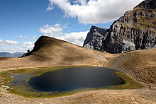
The massif includes several peaks that stand above 2400m. From west to east the most prominent are the following: Astraka, 2436 m (7,992 ft), Ploskos, 2377 m (7,799 ft), Gamila, 2497 m (8,192 ft), Gamila ΙΙ, 2480 m (8,136 ft), Karteros, 2478 m (8,130 ft), Megala Litharia, 2467 m (8,094 ft), Tsouka Rossa, 2379 m (7,805 ft), and Gkoura, 2466 m (8,091 ft). With the exception of Astraka, the peaks are arranged from north to northeast with their southern slopes forming a plateau. Astraka, being the only peak located to the south, dominates that plateau with its north face. A mountain hut, which operates during the summer months, is located at the mountain pass between the peaks of Astraka and Lapatos at 1930m of altitude. Several lakes are formed on the mountain some of whom drain during the summer. From those that maintain water around the year the most famous is Drakolimni
(Dragonlake in Greek), a formation that was created after the retreat of the glacier
s. It is located at a height of 2000 m (6,562 ft) northwest of Ploskos. Its maximum depth is 4.95 m (16 ft), while its surface covers 1 ha (2 acre).
s and is largely composed of Palaeocene-Eocene
limestone, with some exposures of Campanian
-Jurassic
dolomite and limestone on the northern scarp. The lower slopes are dominated by younger flysch
rocks, which consist of thin beds of graded sandstones intercalated with softer, fissile siltstone
s. Extended glacial conditions prevailed on the uplands of Mount Tymfi during the Late Quaternary period, ca. 28,000 years ago. The glacial landscape is well-developed, especially on the southern slopes of Mount Tymfi, across the Astraka-Gamila plateau, and in the upland terrain above the villages of Skamneli
and Tsepelovo
, where lateral and terminal moraine
s form major landscape features. Additional forms of glacial deposits, which extend down to 850 m (2,789 ft) above sea level, include rock glacier
s and limestone pavement
s.
A number of vertical caves and precipices are found in the area around the village of Papingo, which lies near Gamila and Astraka peaks. Some of them bear names inspired from mythology
, such as the Hole of Odysseus
and Chasm of Epos
. These are being studied and explored by caving enthusiasts. The cave of "Provatina" ("Ewe's Cave), with a depth of 408 m (1,339 ft), one of the deepest worldwide, was first discovered in 1965 by British speleologists
of the Cambridge University Caving Club
, and has since then been surveyed by a large number of expeditions. The nearby Chasm of Epos, with a depth of 451 m (1,480 ft), drains the water coming from the surrounding plateaus.
. The Mediterranean character is characterized by the annual distribution of precipitation
, high in the winter months and experiencing a drought
period of two to three months in summer. The continental climatic element is attributed to the high amplitude of annual temperature variation, to such a degree that the difference between mean maximum and mean minimum annual temperature, exceeds 40 °C (104 °F). Extremely low temperatures occur in the area during the winter months. Compared to Mediterranean bioclimatic divisions, the area belongs to the humid zone
with cold winters. It should be noted that conditions in the mountain might be significantly different from those of lower regions in the same area. Winters are particularly harsh and the mountain is covered in snow from autumn until late May.
and visitors should be aware of the limitations to activities imposed by the law. The World Wide Fund for Nature (WWF)
runs an information centre in the village of Papingo.
Tymfi holds the largest recorded population of Balkan chamois
deer (Rupicapra rupicapra balcanica) in Greece, with a population between 120-130 individuals out of an estimated national population between 477-750. Although chamois
is registered as least concern
in IUCN's red list, the subspecies balcanica numbers some thousands of individuals and its populations are believed to be declining. According to the Hellenic Ornithological Society
mount Tymfi along with the neighbouring mountain Smolikas
are important regions for breeding birds of prey, alpine and forest dwelling bird species. The Egyptian Vulture
, Short-toed Snake Eagle, Rufous-tailed Rock-thrush breed in the region, whereas species such as the Golden Eagle
, Red-billed Chough
, Rock Partridge
, Alpine Chough
, Wallcreeper
, White-winged Snowfinch
and the Alpine Accentor
are sedentary. Alpine reptilian and amphibian species are also present. Vipera ursinii
lives in the mountain's subalpine meadows and is considered a threatened taxon. The amphibian Alpine Newt
s (Triturus Alpestris), living in the alpine lakes of the mountain, mostly in and around Drakolimni, are associated with local folktales of dragons and dragon battles. Yellow-bellied Toad
s (Bombina variegata) are also common in that same area.
alpine lake for another 2.8 km or southeast to reach Gamila peak, which is the highest peak of the mountain at 2497 m (8,192 ft) for another 6 km. In both cases there are no signposts and the hikers should solely rely on red dots marked on rocks or scarce small signs attached to wooden poles. The hike from Papingo to the hut lasts between 2–3 hours and the round-trip from the hut to drakolimni another 2 hours.
The mountain is also accessible from other surrounding villages but the trails are longer and the terrain rougher and steeper. Therefore they are suggested for more experienced hikers. From the village of Vrysochori
at the eastern side of the mountain, a trail of 12.8 km leads to Gamila peak through the Karteros Pass. From the village of Vradeto
to the south of the mountain the trail to the peak is approximately 14.9 km. Trails that lead to the mountain can also be followed from Konitsa
and Tsepelovo
. Those routes are poorly and scarcely marked, mostly by dots of red paint on rocks, and are in some cases unclear and covered by vegetation.
s might be compromised if present at all. Furthermore, some locations in the mountain are isolated and rescue services might find it particularly challenging to access the area in case of emergency.
region and the nearest settlements are mainly villages. Iliochori
, Vrysochori
and Laista lie to the east, Skamneli
and Tsepelovo
to the south, and Papingo and Vikos to the west and southwest respectively. Facilities in the aforementioned villages vary, but most of them offer restaurants and accommodation services. The nearest town is Konitsa
to the northwest. The closest city with an airport is Ioannina
, approximately 60 km south of Papingo. The coach service from Ioannina
offers seven daily coaches to Konitsa
and two weekly services to Papingo (on Fridays) as of 2011. The GR-20
(Kozani
- Siatista
- Ioannina
) passes close to the western, northwestern and north sides of the mountain.
Greek language
Greek is an independent branch of the Indo-European family of languages. Native to the southern Balkans, it has the longest documented history of any Indo-European language, spanning 34 centuries of written records. Its writing system has been the Greek alphabet for the majority of its history;...
Τύμφη, ˈtimfi) is a mountain
Mountain
Image:Himalaya_annotated.jpg|thumb|right|The Himalayan mountain range with Mount Everestrect 58 14 160 49 Chomo Lonzorect 200 28 335 52 Makalurect 378 24 566 45 Mount Everestrect 188 581 920 656 Tibetan Plateaurect 250 406 340 427 Rong River...
in the northern Pindus
Pindus
The Pindus mountain range is located in northern Greece and southern Albania. It is roughly 160 km long, with a maximum elevation of 2637 m . Because it runs along the border of Thessaly and Epirus, the Pindus range is often called the "spine of Greece"...
mountain range, northwestern Greece
Greece
Greece , officially the Hellenic Republic , and historically Hellas or the Republic of Greece in English, is a country in southeastern Europe....
. It is part of the regional unit of Ioannina and lies in the region of Zagori
Zagori
Zagori , is a region and a municipality in the Pindus mountains in Epirus, in northwestern Greece. The seat of the municipality is the village Asprangeloi. It has an area of some 1,000 square kilometres and contains 45 villages known as Zagoria , and is in the shape of an upturned equilateral...
, just a few meters south of the 40° parallel. Tymfi forms a massif
Massif
In geology, a massif is a section of a planet's crust that is demarcated by faults or flexures. In the movement of the crust, a massif tends to retain its internal structure while being displaced as a whole...
with its highest peak, Gamila, at 2497 m (8,192 ft), being the sixth highest in Greece
Greece
Greece , officially the Hellenic Republic , and historically Hellas or the Republic of Greece in English, is a country in southeastern Europe....
.
The massif of Tymfi includes in its southern part the Vikos Gorge
Vikos Gorge
The Vikos Gorge is a gorge in the Pindus Mountains of northern Greece. It lies on the southern slopes of Mount Tymfi, with a length of about 20 km, depth ranging from 450 m to 1600 m and width from 400 m to some meters at its narrowest part....
, while they both form part of the Vikos–Aoös National Park which accepts over 100,000 visitors per year. The former municipality of the same name
Tymfi, Greece
Tymfi is a former municipality in the Ioannina peripheral unit, Epirus, Greece. Since the 2011 local government reform it is part of the municipality Zagori, of which it is a municipal unit. Population 1,493...
owed its name to the mountain. It also gave its name to the ancient land known as Tymphaea
Tymphaea
Tymphaea was an ancient Greek region in Epirus inhabited by the Tymphaioi. The area was incorporated into Macedon in 350 BC as part of Upper Macedonia. The most famous native of Tymphaia was Polysperchon, a regent of Macedon....
and to the Tymphaeans, one of the tribes in Ancient Epirus
Epirus (ancient state)
Epirus was an ancient Greek state, located in the geographical region of Epirus, in the western Balkans. The homeland of the ancient Epirotes was bordered by the Aetolian League to the south, Thessalia and Macedonia to the east and Illyrian tribes to the north...
.
Etymology
Tymfi is tranlitareted in similar forms: Tymphe, Timfi, also Tymphi. The name "Tymphe" or "Stymphe" is mentioned by ancient geographer StraboStrabo
Strabo, also written Strabon was a Greek historian, geographer and philosopher.-Life:Strabo was born to an affluent family from Amaseia in Pontus , a city which he said was situated the approximate equivalent of 75 km from the Black Sea...
and it gave its name to the district of Tymphaea
Tymphaea
Tymphaea was an ancient Greek region in Epirus inhabited by the Tymphaioi. The area was incorporated into Macedon in 350 BC as part of Upper Macedonia. The most famous native of Tymphaia was Polysperchon, a regent of Macedon....
and the ancient tribe that inhabited it. The etymology of the peaks are mainly of Greek origin. The highest peak "Gamila" derives from the Greek word for "camel
Camel
A camel is an even-toed ungulate within the genus Camelus, bearing distinctive fatty deposits known as humps on its back. There are two species of camels: the dromedary or Arabian camel has a single hump, and the bactrian has two humps. Dromedaries are native to the dry desert areas of West Asia,...
". "Megala Litharia" stands for "Big rocks" and "Karteros" for "mighty, powerful". The word "Astraka" means "gutter" and its origins can be either Greek or Slavic. A notable exception is the peak of "Tsouka Rossa" which is in Aromanian
Aromanian language
Aromanian , also known as Macedo-Romanian, Arumanian or Vlach is an Eastern Romance language spoken in Southeastern Europe...
and stands for "red peak".
Geography
The mountain is surrounded by various massifs that also form part of the northern PindusPindus
The Pindus mountain range is located in northern Greece and southern Albania. It is roughly 160 km long, with a maximum elevation of 2637 m . Because it runs along the border of Thessaly and Epirus, the Pindus range is often called the "spine of Greece"...
mountain range. Northeast of Tymfi lies the highest mountain of Pindus, Smolikas
Smolikas
Mount Smolikas , also with the o accented , at a height of 2,637 metres above sea level, is the second highest mountain in Greece, after Mount Olympus, and the highest of the Pindus Mountains. The mountain is formed in ophiolite rocks. During the Pleistocene the northern and eastern cirques and...
. The mountain of Trapezitsa lies to the north, Lygkos
Lygkos
Lygkos or Ligkos is a mountain in the eastern Ioannina and the western Grevena prefectures in northwestern Greece. The mountain is a part of the Pindus mountain range. Its maximum elevation is 2,249 m...
to the east and Mitsikeli
Mitsikeli
Mitsikeli is a mountain range in the central part of the Pindus mountains, in Epirus, Greece. The mountain is located northeast of Ioannina and Lake Ioannina. Its highest elevation is 1,810 m....
to the south. The Aoos river flows to the north and its tributary
Tributary
A tributary or affluent is a stream or river that flows into a main stem river or a lake. A tributary does not flow directly into a sea or ocean...
Voidomatis to the southwest. Vikos Gorge
Vikos Gorge
The Vikos Gorge is a gorge in the Pindus Mountains of northern Greece. It lies on the southern slopes of Mount Tymfi, with a length of about 20 km, depth ranging from 450 m to 1600 m and width from 400 m to some meters at its narrowest part....
is formed by the latter to the southwestern side of the mountain. The length of the mountain is approximately 20 to 25 km with a direction from east to west and its width is approximately 15 km from north to south. The southern and southeastern slopes of the mountain are comparatively smooth. The north side, however, forms cliffs reaching 400 m (1,312 ft), whereas the western side is equally steep since the mountain is fragmented by Vikos Gorge
Vikos Gorge
The Vikos Gorge is a gorge in the Pindus Mountains of northern Greece. It lies on the southern slopes of Mount Tymfi, with a length of about 20 km, depth ranging from 450 m to 1600 m and width from 400 m to some meters at its narrowest part....
.
The massif includes several peaks that stand above 2400m. From west to east the most prominent are the following: Astraka, 2436 m (7,992 ft), Ploskos, 2377 m (7,799 ft), Gamila, 2497 m (8,192 ft), Gamila ΙΙ, 2480 m (8,136 ft), Karteros, 2478 m (8,130 ft), Megala Litharia, 2467 m (8,094 ft), Tsouka Rossa, 2379 m (7,805 ft), and Gkoura, 2466 m (8,091 ft). With the exception of Astraka, the peaks are arranged from north to northeast with their southern slopes forming a plateau. Astraka, being the only peak located to the south, dominates that plateau with its north face. A mountain hut, which operates during the summer months, is located at the mountain pass between the peaks of Astraka and Lapatos at 1930m of altitude. Several lakes are formed on the mountain some of whom drain during the summer. From those that maintain water around the year the most famous is Drakolimni
Drakolimni
Drakolimni is the name of several alpine or sub-alpine lakes in northwestern Greece Epirus region: the ones in mountain Tymfi and Smolikas are the most widely known...
(Dragonlake in Greek), a formation that was created after the retreat of the glacier
Glacier
A glacier is a large persistent body of ice that forms where the accumulation of snow exceeds its ablation over many years, often centuries. At least 0.1 km² in area and 50 m thick, but often much larger, a glacier slowly deforms and flows due to stresses induced by its weight...
s. It is located at a height of 2000 m (6,562 ft) northwest of Ploskos. Its maximum depth is 4.95 m (16 ft), while its surface covers 1 ha (2 acre).
Geology
Mount Tymfi represents a series of uplifted fault blocks and faulted escarpmentEscarpment
An escarpment is a steep slope or long cliff that occurs from erosion or faulting and separates two relatively level areas of differing elevations.-Description and variants:...
s and is largely composed of Palaeocene-Eocene
Eocene
The Eocene Epoch, lasting from about 56 to 34 million years ago , is a major division of the geologic timescale and the second epoch of the Paleogene Period in the Cenozoic Era. The Eocene spans the time from the end of the Palaeocene Epoch to the beginning of the Oligocene Epoch. The start of the...
limestone, with some exposures of Campanian
Campanian
The Campanian is, in the ICS' geologic timescale, the fifth of six ages of the Late Cretaceous epoch . The Campanian spans the time from 83.5 ± 0.7 Ma to 70.6 ± 0.6 Ma ...
-Jurassic
Jurassic
The Jurassic is a geologic period and system that extends from about Mya to Mya, that is, from the end of the Triassic to the beginning of the Cretaceous. The Jurassic constitutes the middle period of the Mesozoic era, also known as the age of reptiles. The start of the period is marked by...
dolomite and limestone on the northern scarp. The lower slopes are dominated by younger flysch
Flysch
Flysch is a sequence of sedimentary rocks that is deposited in a deep marine facies in the foreland basin of a developing orogen. Flysch is typically deposited during an early stage of the orogenesis. When the orogen evolves the foreland basin becomes shallower and molasse is deposited on top of...
rocks, which consist of thin beds of graded sandstones intercalated with softer, fissile siltstone
Siltstone
Siltstone is a sedimentary rock which has a grain size in the silt range, finer than sandstone and coarser than claystones.- Description :As its name implies, it is primarily composed of silt sized particles, defined as grains 1/16 - 1/256 mm or 4 to 8 on the Krumbein phi scale...
s. Extended glacial conditions prevailed on the uplands of Mount Tymfi during the Late Quaternary period, ca. 28,000 years ago. The glacial landscape is well-developed, especially on the southern slopes of Mount Tymfi, across the Astraka-Gamila plateau, and in the upland terrain above the villages of Skamneli
Skamneli
Skamneli is a village in the Zagori region , 54 km north of Ioannina. It is built in the fringes of mountain Tymfi , at a height of 1160 m.- Name :...
and Tsepelovo
Tsepelovo
Tsepelovo , older form: -on is a village in the Zagori region . It stands at a height of 1,200 meters in a panoramic location on the mountain range of Tymfi. It is the biggest of the 45 villages of Zagori and it was the seat of Tymfi municipality...
, where lateral and terminal moraine
Moraine
A moraine is any glacially formed accumulation of unconsolidated glacial debris which can occur in currently glaciated and formerly glaciated regions, such as those areas acted upon by a past glacial maximum. This debris may have been plucked off a valley floor as a glacier advanced or it may have...
s form major landscape features. Additional forms of glacial deposits, which extend down to 850 m (2,789 ft) above sea level, include rock glacier
Rock glacier
Rock glaciers are distinctive geomorphological landforms of angular rock debris frozen in interstitial ice which may extend outward and downslope from talus cones, glaciers or terminal moraines of glaciers. There are two types of rock glaciers: periglacial glaciers, or talus-derived glaciers, and...
s and limestone pavement
Limestone pavement
A limestone pavement is a natural karst landform consisting of a flat, incised surface of exposed limestone that resembles an artificial pavement. The term is mainly used in the UK where many of these landforms have developed distinctive surface patterning resembling block of paving...
s.
A number of vertical caves and precipices are found in the area around the village of Papingo, which lies near Gamila and Astraka peaks. Some of them bear names inspired from mythology
Greek mythology
Greek mythology is the body of myths and legends belonging to the ancient Greeks, concerning their gods and heroes, the nature of the world, and the origins and significance of their own cult and ritual practices. They were a part of religion in ancient Greece...
, such as the Hole of Odysseus
Odysseus
Odysseus or Ulysses was a legendary Greek king of Ithaca and the hero of Homer's epic poem the Odyssey. Odysseus also plays a key role in Homer's Iliad and other works in the Epic Cycle....
and Chasm of Epos
Epic poetry
An epic is a lengthy narrative poem, ordinarily concerning a serious subject containing details of heroic deeds and events significant to a culture or nation. Oral poetry may qualify as an epic, and Albert Lord and Milman Parry have argued that classical epics were fundamentally an oral poetic form...
. These are being studied and explored by caving enthusiasts. The cave of "Provatina" ("Ewe's Cave), with a depth of 408 m (1,339 ft), one of the deepest worldwide, was first discovered in 1965 by British speleologists
Speleology
Speleology is the scientific study of caves and other karst features, their make-up, structure, physical properties, history, life forms, and the processes by which they form and change over time...
of the Cambridge University Caving Club
Cambridge University Caving Club
The Cambridge University Caving Club was founded in 1949. The club organizes SRT training, social events, and weekend caving trips as well as longer expeditions.Currently, annual expeditions are carried out to the Ardèche region of France for sport...
, and has since then been surveyed by a large number of expeditions. The nearby Chasm of Epos, with a depth of 451 m (1,480 ft), drains the water coming from the surrounding plateaus.
Climate
There is no meteorological station at the mountain itself and the closest one is located at the village of Papingo. The overal climate of the Vikos–Aoös National Park which includes the mountain is Mediterranean, transitioning to continentalContinental climate
Continental climate is a climate characterized by important annual variation in temperature due to the lack of significant bodies of water nearby...
. The Mediterranean character is characterized by the annual distribution of precipitation
Precipitation (meteorology)
In meteorology, precipitation In meteorology, precipitation In meteorology, precipitation (also known as one of the classes of hydrometeors, which are atmospheric water phenomena is any product of the condensation of atmospheric water vapor that falls under gravity. The main forms of precipitation...
, high in the winter months and experiencing a drought
Drought
A drought is an extended period of months or years when a region notes a deficiency in its water supply. Generally, this occurs when a region receives consistently below average precipitation. It can have a substantial impact on the ecosystem and agriculture of the affected region...
period of two to three months in summer. The continental climatic element is attributed to the high amplitude of annual temperature variation, to such a degree that the difference between mean maximum and mean minimum annual temperature, exceeds 40 °C (104 °F). Extremely low temperatures occur in the area during the winter months. Compared to Mediterranean bioclimatic divisions, the area belongs to the humid zone
Humid subtropical climate
A humid subtropical climate is a climate zone characterized by hot, humid summers and mild to cool winters...
with cold winters. It should be noted that conditions in the mountain might be significantly different from those of lower regions in the same area. Winters are particularly harsh and the mountain is covered in snow from autumn until late May.
Wildlife
Most part of the mountain, with the exception of its southernmost part around the peak of Astraka, forms part of the Vikos–Aoös National Park. The park is a designated protected areaProtected area
Protected areas are locations which receive protection because of their recognised natural, ecological and/or cultural values. There are several kinds of protected areas, which vary by level of protection depending on the enabling laws of each country or the regulations of the international...
and visitors should be aware of the limitations to activities imposed by the law. The World Wide Fund for Nature (WWF)
World Wide Fund for Nature
The World Wide Fund for Nature is an international non-governmental organization working on issues regarding the conservation, research and restoration of the environment, formerly named the World Wildlife Fund, which remains its official name in Canada and the United States...
runs an information centre in the village of Papingo.
Tymfi holds the largest recorded population of Balkan chamois
Chamois
The chamois, Rupicapra rupicapra, is a goat-antelope species native to mountains in Europe, including the Carpathian Mountains of Romania, the European Alps, the Tatra Mountains, the Balkans, parts of Turkey, and the Caucasus. The chamois has also been introduced to the South Island of New Zealand...
deer (Rupicapra rupicapra balcanica) in Greece, with a population between 120-130 individuals out of an estimated national population between 477-750. Although chamois
Chamois
The chamois, Rupicapra rupicapra, is a goat-antelope species native to mountains in Europe, including the Carpathian Mountains of Romania, the European Alps, the Tatra Mountains, the Balkans, parts of Turkey, and the Caucasus. The chamois has also been introduced to the South Island of New Zealand...
is registered as least concern
Least Concern
Least Concern is an IUCN category assigned to extant taxon or lower taxa which have been evaluated but do not qualify for any other category. As such they do not qualify as threatened, Near Threatened, or Conservation Dependent...
in IUCN's red list, the subspecies balcanica numbers some thousands of individuals and its populations are believed to be declining. According to the Hellenic Ornithological Society
Hellenic Ornithological Society
The Hellenic Ornithological Society is a Greek non-governmental body exclusively concerned with the protection of wild birds and their habitats in Greece. It is a Non-Profit Organization founded in 1982. It is the Greek partner of BirdLife International....
mount Tymfi along with the neighbouring mountain Smolikas
Smolikas
Mount Smolikas , also with the o accented , at a height of 2,637 metres above sea level, is the second highest mountain in Greece, after Mount Olympus, and the highest of the Pindus Mountains. The mountain is formed in ophiolite rocks. During the Pleistocene the northern and eastern cirques and...
are important regions for breeding birds of prey, alpine and forest dwelling bird species. The Egyptian Vulture
Egyptian Vulture
The Egyptian Vulture is a small Old World vulture, found widely distributed from southwestern Europe and northern Africa to southern Asia. It is the only living member of the genus Neophron. It has sometimes also been known as the White Scavenger Vulture or Pharaoh's Chicken...
, Short-toed Snake Eagle, Rufous-tailed Rock-thrush breed in the region, whereas species such as the Golden Eagle
Golden Eagle
The Golden Eagle is one of the best known birds of prey in the Northern Hemisphere. Like all eagles, it belongs to the family Accipitridae. Once widespread across the Holarctic, it has disappeared from many of the more heavily populated areas...
, Red-billed Chough
Red-billed Chough
The Red-billed Chough or Chough , Pyrrhocorax pyrrhocorax, is a bird in the crow family; it is one of only two species in the genus Pyrrhocorax...
, Rock Partridge
Rock Partridge
The Rock Partridge, Alectoris graeca, is a gamebird in the pheasant family Phasianidae of the order Galliformes, gallinaceous birds.This partridge has its main range in southwestern Asia and southeastern Europe, and is closely related and very similar to its eastern equivalent, the Chukar...
, Alpine Chough
Alpine Chough
The Alpine Chough , or Yellow-billed Chough, is a bird in the crow family, one of only two species in the genus Pyrrhocorax. Its two subspecies breed in high mountains from Spain east through southern Europe and North Africa to Central Asia, India and China, and it may nest at a higher altitude...
, Wallcreeper
Wallcreeper
The Wallcreeper is a small passerine bird found throughout the high mountains of Eurasia. It is the only member of the genus Tichodroma.-Taxonomy and etymology:...
, White-winged Snowfinch
White-winged Snowfinch
The White-winged Snowfinch , or just Snowfinch, is a small passerine bird. Despite its name, it is a sparrow rather than a true finch.-Distribution and habitat:...
and the Alpine Accentor
Alpine Accentor
The Alpine Accentor, Prunella collaris, is a small passerine bird found throughout the mountains of southern temperate Europe and Asia at heights above 2000 m. It is mainly resident, wintering more widely at lower latitudes, but some birds wander as rare vagrants as far as Great Britain.It is...
are sedentary. Alpine reptilian and amphibian species are also present. Vipera ursinii
Vipera ursinii
Vipera ursinii is a venomous viper and a very widespread species, found from southeastern France all the way to China . No subspecies are currently recognized...
lives in the mountain's subalpine meadows and is considered a threatened taxon. The amphibian Alpine Newt
Alpine Newt
The Alpine Newt is a newt of the Salamander order Caudata in the class of Amphibians.-Description:...
s (Triturus Alpestris), living in the alpine lakes of the mountain, mostly in and around Drakolimni, are associated with local folktales of dragons and dragon battles. Yellow-bellied Toad
Yellow-bellied toad
The Yellow-Bellied Toad belongs to the order of Anura, the archaeobatrachial family of Bombinatoridae, and to the genus of fire-bellied toads.- Anatomy :...
s (Bombina variegata) are also common in that same area.
Ascent routes
The simplest and most commonly used route of ascent is the one beginning at the village of Mikro Papingo, located at the western side of the mountain at an altitude of 980 m (3,215 ft). The trail that leads to the Astraka mountain hut, is approximately 6 km long. It is part of the Greek national trail O3 and is generally well marked with signs (red diamond on white) and red dots and arrows on rocks and tree trunks. From the hut, the hikers might either head northeast to the drakolimniDrakolimni
Drakolimni is the name of several alpine or sub-alpine lakes in northwestern Greece Epirus region: the ones in mountain Tymfi and Smolikas are the most widely known...
alpine lake for another 2.8 km or southeast to reach Gamila peak, which is the highest peak of the mountain at 2497 m (8,192 ft) for another 6 km. In both cases there are no signposts and the hikers should solely rely on red dots marked on rocks or scarce small signs attached to wooden poles. The hike from Papingo to the hut lasts between 2–3 hours and the round-trip from the hut to drakolimni another 2 hours.
The mountain is also accessible from other surrounding villages but the trails are longer and the terrain rougher and steeper. Therefore they are suggested for more experienced hikers. From the village of Vrysochori
Vrysochori
Vrysochori is one of the Zagori villages , in the Ioannina Prefecture, Greece. Vrysochori is in the Tymfi municipality, and is about 75 km from Ioannina.- Location and climate :...
at the eastern side of the mountain, a trail of 12.8 km leads to Gamila peak through the Karteros Pass. From the village of Vradeto
Vradeto
Vradeto , older form: -on is a village in the Greek Zagori region . It lies at a height of 1340m on Mt Tymphe on the Pindus mountainrange. Its location is the highest among the 44 villages of Zagori. It is the middle of the Vikos–Aoös National Park and is about 50 km away from Ioannina...
to the south of the mountain the trail to the peak is approximately 14.9 km. Trails that lead to the mountain can also be followed from Konitsa
Konitsa
Konitsa is a town in Epirus, Greece, near the Albanian border. It lies amphi-theatre shaped on a mountain slope of the Pindos mountain range, overlooking the valley where the river Aoos meets the river Voidomatis. The valley is used for farming. Konitsa is a regional centre for many small Pindos...
and Tsepelovo
Tsepelovo
Tsepelovo , older form: -on is a village in the Zagori region . It stands at a height of 1,200 meters in a panoramic location on the mountain range of Tymfi. It is the biggest of the 45 villages of Zagori and it was the seat of Tymfi municipality...
. Those routes are poorly and scarcely marked, mostly by dots of red paint on rocks, and are in some cases unclear and covered by vegetation.
Climbing
The first recorded climb of the mountain was made on 7–8 June 1956 by Giorgos Michailidis and Giorgos Xanthopoulos who climbed the face of Gamila. Four years later, on 25–26 August 1960, Guido Magnone and Spyros Antypas climbed the northeastern face of Gamila. Currently there are 17 climbing fields on the mountain, covering most of the major peaks and other geological features of the mountain. From the aforementioned fields, the northeastern face of Gamila counts 8 climbing routes, and Gamila II 6. The fields of Astraka and Tsouka Rossa have several climbing routes each. The former counts 30 routes in both its northwestern and northeastern faces, and the latter 19 routes. Potential climbers should take into account that several of the routes were first ascended several years ago and thus pitonPiton
In climbing, a piton is a metal spike that is driven into a crack or seam in the rock with a hammer, and which acts as an anchor to protect the climber against the consequences of a fall, or to assist progress in aid climbing...
s might be compromised if present at all. Furthermore, some locations in the mountain are isolated and rescue services might find it particularly challenging to access the area in case of emergency.
Αccess
The mountain is located at the ZagoriZagori
Zagori , is a region and a municipality in the Pindus mountains in Epirus, in northwestern Greece. The seat of the municipality is the village Asprangeloi. It has an area of some 1,000 square kilometres and contains 45 villages known as Zagoria , and is in the shape of an upturned equilateral...
region and the nearest settlements are mainly villages. Iliochori
Iliochori
Iliochori is one of the Zagori villages of Greece. It is located in the municipal unit of Tymfi in the northern part of the Ioannina prefecture. It is also known as Dobrinovo . According to a local legend, the village was founded as Rasciana, on the river of the same name...
, Vrysochori
Vrysochori
Vrysochori is one of the Zagori villages , in the Ioannina Prefecture, Greece. Vrysochori is in the Tymfi municipality, and is about 75 km from Ioannina.- Location and climate :...
and Laista lie to the east, Skamneli
Skamneli
Skamneli is a village in the Zagori region , 54 km north of Ioannina. It is built in the fringes of mountain Tymfi , at a height of 1160 m.- Name :...
and Tsepelovo
Tsepelovo
Tsepelovo , older form: -on is a village in the Zagori region . It stands at a height of 1,200 meters in a panoramic location on the mountain range of Tymfi. It is the biggest of the 45 villages of Zagori and it was the seat of Tymfi municipality...
to the south, and Papingo and Vikos to the west and southwest respectively. Facilities in the aforementioned villages vary, but most of them offer restaurants and accommodation services. The nearest town is Konitsa
Konitsa
Konitsa is a town in Epirus, Greece, near the Albanian border. It lies amphi-theatre shaped on a mountain slope of the Pindos mountain range, overlooking the valley where the river Aoos meets the river Voidomatis. The valley is used for farming. Konitsa is a regional centre for many small Pindos...
to the northwest. The closest city with an airport is Ioannina
Ioannina
Ioannina , often called Jannena within Greece, is the largest city of Epirus, north-western Greece, with a population of 70,203 . It lies at an elevation of approximately 500 meters above sea level, on the western shore of lake Pamvotis . It is located within the Ioannina municipality, and is the...
, approximately 60 km south of Papingo. The coach service from Ioannina
Ioannina
Ioannina , often called Jannena within Greece, is the largest city of Epirus, north-western Greece, with a population of 70,203 . It lies at an elevation of approximately 500 meters above sea level, on the western shore of lake Pamvotis . It is located within the Ioannina municipality, and is the...
offers seven daily coaches to Konitsa
Konitsa
Konitsa is a town in Epirus, Greece, near the Albanian border. It lies amphi-theatre shaped on a mountain slope of the Pindos mountain range, overlooking the valley where the river Aoos meets the river Voidomatis. The valley is used for farming. Konitsa is a regional centre for many small Pindos...
and two weekly services to Papingo (on Fridays) as of 2011. The GR-20
Greek National Road 20
The Greek National Road 20 or the Diagoniki Odos? is a highway or route that links the city of Kozani and Ioannina via Siatista and Konitsa. The highway is entirely the E92 for its entire length...
(Kozani
Kozani
Kozani is a city in northern Greece, capital of Kozani regional unit and of West Macedonia region. It is located in the western part of Macedonia, in the northern part of the Aliakmonas river valley...
- Siatista
Siatista
Siatista is a town and a former municipality in Kozani peripheral unit, West Macedonia, Greece. Since the 2011 local government reform it is part of the municipality Voio, of which it is the seat and a municipal unit. It lies 28 km southwest of the city Kozani. It was built on the austral...
- Ioannina
Ioannina
Ioannina , often called Jannena within Greece, is the largest city of Epirus, north-western Greece, with a population of 70,203 . It lies at an elevation of approximately 500 meters above sea level, on the western shore of lake Pamvotis . It is located within the Ioannina municipality, and is the...
) passes close to the western, northwestern and north sides of the mountain.