
Txindoki
Encyclopedia
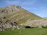
Txindoki or Larrunarri is an iconic mountain (1,346 m) located in the region of Goierri
, Gipuzkoa, in the Basque Autonomous Community
of Spain
. Originally Larrunarri or Ñañarri (IPA: [ɲa'ɲari)], the mount took on the popularized name Txindoki by extension after some shepherd huts nearby. It is sometimes referred to as the Basque Matterhorn
too, because of its pyramidal shape.
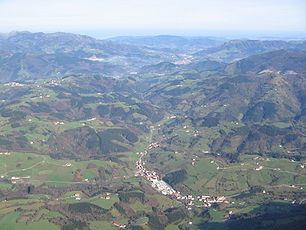
It stands out as the westernmost mountainous tip of the Aralar mountain range, with an easily recognized image that has become a symbol for all the Goierri
valley. The towering mountain stands above the northern town Amezketa
and its scattered farmhouses at its foot. For the most part, it is not covered in forest just like most of the Gipuzkoan side of Aralar. The steep slopes of the northern face and the Muitze valley are the wild part of Txindoki. The northern and southern side are clearly delimited by a rocky limestone
crest running east to west up to the summit, which is almost entirely bare rock. The steep sides of the crest are popular with amateur rock climbers.
 The main and most popular access point is from the neighbourhood Larraitz (IPA: [la'raits]). From Alegia
(N-1) the minor road GI-3670 that switches to the GI-2133 in the last stretch reaches Larraitz in about 15 minutes; alternatively, it can be reached by taking the GI-2133 starting in Ordizia
(N-1 E-05 E-80), taking about the same time. Larraitz, lying at 403 m (943 m below the summit), harbours the long picnic area and car park Zamao, with a couple of café-restaurants (former farmhouses) and a hermitage (XVIIth century) all surrounded by gentle fields.
From the southern end of the area, a broad dust track heads south-west, forking shortly afterwards with the left hand track leading to Txindoki. The broad track peters out into a beaten trail that turns east at the lower end of the crest (15 min). Next, it cuts its way straight across the southern side of the mountain along a pine tree
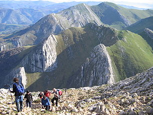
plantation on the right till the spring Oria is reached at a sharp bend. After some zigzag and steep slopes heading south-west (1h00), the huts of Zirigarate are reached, which stand on a hollow. From Zirigarate, the trail heads east to the col of Egurral (1,152 m), the last milestone before the final struggle to the summit largely through karst
terrain (1h45). On sunny Sundays of Summer and Spring people walk in droves to the top. Breathtaking scenery from the peak all over Gipuzkoa and Aralar
on a clear day. The summit is covered with small memorials and a postbox for hikers.
 Alternatively, the hard way up can be taken at the rise Oria by heading east out of the main trail through a tough grassy slope that ends up at the col of Egurral.
dwells in a crack on the rock (Marizulo). By clinging to the steep path, the pass of Egurral is reached (1h45).
) enlivening the atmosphere and stalls featuring rural produce, eg cider and cheese, as well as crafted products. In 2008 18,000 sheep, 650 mares and 700 cows were expected to follow the seasonal migration to Aralar
.
On June 29, Saint Peter's day, a big and popular religious celebration is held at the hermitage (a gathering called erromeria in Basque
).
Goierri
Goierri is one of the eight regions in Gipuzkoa, formed by 18 municipalities, Beasain, Lazkao and Ordizia being the main towns.-External links:* ////....
, Gipuzkoa, in the Basque Autonomous Community
Basque Country (autonomous community)
The Basque Country is an autonomous community of northern Spain. It includes the Basque provinces of Álava, Biscay and Gipuzkoa, also called Historical Territories....
of Spain
Spain
Spain , officially the Kingdom of Spain languages]] under the European Charter for Regional or Minority Languages. In each of these, Spain's official name is as follows:;;;;;;), is a country and member state of the European Union located in southwestern Europe on the Iberian Peninsula...
. Originally Larrunarri or Ñañarri (IPA: [ɲa'ɲari)], the mount took on the popularized name Txindoki by extension after some shepherd huts nearby. It is sometimes referred to as the Basque Matterhorn
Matterhorn
The Matterhorn , Monte Cervino or Mont Cervin , is a mountain in the Pennine Alps on the border between Switzerland and Italy. Its summit is 4,478 metres high, making it one of the highest peaks in the Alps. The four steep faces, rising above the surrounding glaciers, face the four compass points...
too, because of its pyramidal shape.
It stands out as the westernmost mountainous tip of the Aralar mountain range, with an easily recognized image that has become a symbol for all the Goierri
Goierri
Goierri is one of the eight regions in Gipuzkoa, formed by 18 municipalities, Beasain, Lazkao and Ordizia being the main towns.-External links:* ////....
valley. The towering mountain stands above the northern town Amezketa
Amezketa
Amezketa is a town located in the province of Gipuzkoa, in the Basque Autonomous Community, in the north of Spain.-External links:* Information available in Spanish and Basque.* Information available in Spanish...
and its scattered farmhouses at its foot. For the most part, it is not covered in forest just like most of the Gipuzkoan side of Aralar. The steep slopes of the northern face and the Muitze valley are the wild part of Txindoki. The northern and southern side are clearly delimited by a rocky limestone
Limestone
Limestone is a sedimentary rock composed largely of the minerals calcite and aragonite, which are different crystal forms of calcium carbonate . Many limestones are composed from skeletal fragments of marine organisms such as coral or foraminifera....
crest running east to west up to the summit, which is almost entirely bare rock. The steep sides of the crest are popular with amateur rock climbers.
Main route
Alegia
Alegia is a town located in the province of Gipuzkoa, in the autonomous community of Basque Country, in the North of Spain. On 2003 Alegia had a total population of 1,612.-External links:...
(N-1) the minor road GI-3670 that switches to the GI-2133 in the last stretch reaches Larraitz in about 15 minutes; alternatively, it can be reached by taking the GI-2133 starting in Ordizia
Ordizia
Ordizia is a town and municipality located in the Goierri region of the province of Gipuzkoa, in the autonomous community of the Basque Country, northern Spain.The professional cycle road race Prueba Villafranca de Ordizia is held yearly in Ordizia....
(N-1 E-05 E-80), taking about the same time. Larraitz, lying at 403 m (943 m below the summit), harbours the long picnic area and car park Zamao, with a couple of café-restaurants (former farmhouses) and a hermitage (XVIIth century) all surrounded by gentle fields.
From the southern end of the area, a broad dust track heads south-west, forking shortly afterwards with the left hand track leading to Txindoki. The broad track peters out into a beaten trail that turns east at the lower end of the crest (15 min). Next, it cuts its way straight across the southern side of the mountain along a pine tree
Monterey Pine
The Monterey Pine, Pinus radiata, family Pinaceae, also known as the Insignis Pine or Radiata Pine is a species of pine native to the Central Coast of California....
plantation on the right till the spring Oria is reached at a sharp bend. After some zigzag and steep slopes heading south-west (1h00), the huts of Zirigarate are reached, which stand on a hollow. From Zirigarate, the trail heads east to the col of Egurral (1,152 m), the last milestone before the final struggle to the summit largely through karst
KARST
Kilometer-square Area Radio Synthesis Telescope is a Chinese telescope project to which FAST is a forerunner. KARST is a set of large spherical reflectors on karst landforms, which are bowlshaped limestone sinkholes named after the Kras region in Slovenia and Northern Italy. It will consist of...
terrain (1h45). On sunny Sundays of Summer and Spring people walk in droves to the top. Breathtaking scenery from the peak all over Gipuzkoa and Aralar
Aralar
Aralar may refer to:*Aralar Range, a mountain range*Aralar Party, a political party...
on a clear day. The summit is covered with small memorials and a postbox for hikers.
The Muitze route
Another option consists of starting off from Larraitz with a view to ascending through the northern wild valley of Muitze, unknown to most hikers. This time the same track may be followed in the beginning for a convenient and gentle stroll, until a winding slope is overcome some minutes before the turning of the crest (milestone Gazteraztegi, 520 m). There a broad track sets off back in the opposite direction, going up until it gets to an aerial at Urtzabal goikoa (610 m). Alternatively, a short-cut heads up cross-country straight on to the aerial from Larraitz, so gaining height in little time but with some effort. Right before the final slope to the aerial, a narrow path bounds south-east on the left into the tough and vertical valley carved by the stream Muitze (waterfalls on the way). The trail snakes out of the forest to the right and crosses the stream at the point where the forest landscape gives way to grassland. After overcoming the rocks, the stream must be crossed again to the right. A trail on the steep slopes on the right leads to the hut Txindoki and an orchard that provided the current name to the mountain. Legend has it, close to this place the mythological character/goddess MariMari (goddess)
Mari, Mari Urraca, Anbotoko Mari and the possibly distinct Murumendiko Dama was a goddess — a lamia — of the Basques. She was married to the god Sugaar...
dwells in a crack on the rock (Marizulo). By clinging to the steep path, the pass of Egurral is reached (1h45).
Events
Every year on 1 May, flocks of cattle are gathered in Larraitz to be herded to the highland grasslands until October. The meeting takes place in a cheerful environment, with numerous public, traditional music (trikitixaTrikitixa
The trikiti , trikitixa or eskusoinu txiki is a two-row Basque diatonic button accordion with right-hand rows keyed a fifth apart and twelve unisonoric bass buttons...
) enlivening the atmosphere and stalls featuring rural produce, eg cider and cheese, as well as crafted products. In 2008 18,000 sheep, 650 mares and 700 cows were expected to follow the seasonal migration to Aralar
Aralar
Aralar may refer to:*Aralar Range, a mountain range*Aralar Party, a political party...
.
On June 29, Saint Peter's day, a big and popular religious celebration is held at the hermitage (a gathering called erromeria in Basque
Basque language
Basque is the ancestral language of the Basque people, who inhabit the Basque Country, a region spanning an area in northeastern Spain and southwestern France. It is spoken by 25.7% of Basques in all territories...
).