

Turin Papyrus Map
Encyclopedia
Ancient Egypt
Ancient Egypt was an ancient civilization of Northeastern Africa, concentrated along the lower reaches of the Nile River in what is now the modern country of Egypt. Egyptian civilization coalesced around 3150 BC with the political unification of Upper and Lower Egypt under the first pharaoh...
ian map
Map
A map is a visual representation of an area—a symbolic depiction highlighting relationships between elements of that space such as objects, regions, and themes....
, generally considered the oldest surviving map of topographical interest from the ancient world. It is drawn on a papyrus
Papyrus
Papyrus is a thick paper-like material produced from the pith of the papyrus plant, Cyperus papyrus, a wetland sedge that was once abundant in the Nile Delta of Egypt....
reportedly discovered at Deir el-Medina in Thebes
Thebes, Egypt
Thebes is the Greek name for a city in Ancient Egypt located about 800 km south of the Mediterranean, on the east bank of the river Nile within the modern city of Luxor. The Theban Necropolis is situated nearby on the west bank of the Nile.-History:...
, collected by Bernardino Drovetti
Bernardino Drovetti
Bernardino Michele Maria Drovetti was an Italian diplomat, lawyer, explorer and antiquarian, appointed by Napoleon as French consul to Egypt at a time when the country and its antiquities were being opened rapidly to European knowledge and acquisition. His methods were deplorable...
(known as Napoleon's Proconsul) in Egypt sometime before 1824 AD and now preserved in Turin
Turin
Turin is a city and major business and cultural centre in northern Italy, capital of the Piedmont region, located mainly on the left bank of the Po River and surrounded by the Alpine arch. The population of the city proper is 909,193 while the population of the urban area is estimated by Eurostat...
's Museo Egizio
Museo Egizio
The Museo Egizio is a museum in Turin, Italy, specialising in Egyptian archaeology and anthropology. It houses the world's largest and most comprehensive collection of Egyptian antiquities outside the Egyptian Museum in Cairo...
. The map was drawn about 1160 BC by the well-known Scribe-of-the-Tomb Amennakhte, son of Ipuy. It was prepared for Ramesses IV
Ramesses IV
Heqamaatre Ramesses IV was the third pharaoh of the Twentieth Dynasty of the New Kingdom of Ancient Egypt. His name prior to assuming the crown was Amonhirkhopshef...
's quarrying expedition to the Wadi Hammamat
Wadi Hammamat
' is a dry river bed in Egypt's Eastern Desert, about halfway between Qusier and Qena. It was a major mining region and trade route east from the Nile Valley in ancient times, and three thousand years of rock carvings and graffiti make it a major scientific and tourist site today.-Trade...
in the Eastern Desert
Eastern Desert
The Eastern Desert is the section of Sahara Desert east of the Nile River, between the river and the Red Sea. It extends from Egypt in the north to Eritrea in the south, and also comprises parts of Sudan and Ethiopia.-Features:...
, which exposes Precambrian
Precambrian
The Precambrian is the name which describes the large span of time in Earth's history before the current Phanerozoic Eon, and is a Supereon divided into several eons of the geologic time scale...
rocks of the Arabian-Nubian Shield
Arabian-Nubian Shield
The Arabian-Nubian Shield is an exposure of Precambrian crystalline rocks on the flanks of the Red Sea. The crystalline rocks are mostly Neoproterozoic in age. Geographically - and from north to south - the ANS includes the nations of Israel, Jordan. Egypt, Saudi Arabia, Sudan, Eritrea,...
. The purpose of the expedition was to obtain blocks of bekhen-stone (metagraywacke sandstone
Sandstone
Sandstone is a sedimentary rock composed mainly of sand-sized minerals or rock grains.Most sandstone is composed of quartz and/or feldspar because these are the most common minerals in the Earth's crust. Like sand, sandstone may be any colour, but the most common colours are tan, brown, yellow,...
) to be used for statues of the king.
Description
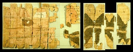
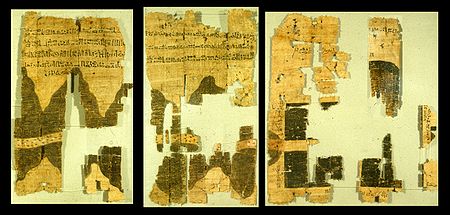
The map shows a 15-kilometre stretch of Wadi Hammamat and has depictions of this wadiWadi
Wadi is the Arabic term traditionally referring to a valley. In some cases, it may refer to a dry riverbed that contains water only during times of heavy rain or simply an intermittent stream.-Variant names:...
's confluence with wadis Atalla and el-Sid, the surrounding hills, the bekhen-stone quarry, and the gold
Gold
Gold is a chemical element with the symbol Au and an atomic number of 79. Gold is a dense, soft, shiny, malleable and ductile metal. Pure gold has a bright yellow color and luster traditionally considered attractive, which it maintains without oxidizing in air or water. Chemically, gold is a...
mine and settlement at Bir Umm Fawakhir. It also includes numerous annotations identifying the features shown on the map, the destinations of the wadi routes, the distance between the quarry and mine, the location of gold deposits in the hills, and the sizes of the bekhen-stone blocks quarried. The top of the map is toward the south and the source of the Nile River. As currently reconstructed in the Turin Museum, the map measures 2.8 m long by 0.41 m wide. This arrangement of the map fragments is currently considered incorrect however. A new, more accurate reconstruction was proposed by Harrell and Brown (1992a, 1992b).
Besides being a topographic map
Topographic map
A topographic map is a type of map characterized by large-scale detail and quantitative representation of relief, usually using contour lines in modern mapping, but historically using a variety of methods. Traditional definitions require a topographic map to show both natural and man-made features...
of surprisingly modern aspect, the Turin Papyrus is also a geological map (the earliest known) because it accurately shows the local distribution of different rock types (with black and pink hills) and the lithologically
Lithology
The lithology of a rock unit is a description of its physical characteristics visible at outcrop, in hand or core samples or with low magnification microscopy, such as colour, texture, grain size, or composition. It may be either a detailed description of these characteristics or be a summary of...
diverse wadi gravel
Gravel
Gravel is composed of unconsolidated rock fragments that have a general particle size range and include size classes from granule- to boulder-sized fragments. Gravel can be sub-categorized into granule and cobble...
s (with brown, green and white dots), and it contains information on quarrying and mining. The draughtsman clearly and carefully distributed distinctive features in accordance with the reality of a particular area, adding clarity by the use of legends and contrasting colors. In this respect, the Turin Papyrus may be regarded as the earliest known Geographic Information System
Geographic Information System
A geographic information system, geographical information science, or geospatial information studies is a system designed to capture, store, manipulate, analyze, manage, and present all types of geographically referenced data...
.
The location of the map on the ground has been identified and has been shown to be accurate.