

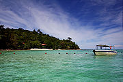
Tunku Abdul Rahman National Park
Encyclopedia
The Tunku Abdul Rahman
Marine Park comprises a group of 5 islands located between 3 to 8 km off Kota Kinabalu
. The park is spread over 4,929 hectares, two thirds of which cover the sea. Before the Ice Age, it formed part of the Crocker Range mass of sandstone and sedimentary rock on the mainland. However, about one million years ago, the melting ice brought about changes in the sea level and parts of the mainland were cut off by the sea to form the islands of Gaya Island, Sapi Island, Manukan Island, Mamutik Island and Sulug Island. Evidence of this can be seen from the exposed sandstone of the coastline forming the cliffs, caves, honeycombs and deep crevices.
Jesselton Point Ferry Terminal in downtown Kota Kinabalu is the ferry terminal for those heading to the islands in Tunku Abdul Rahman
Marine Park (Gaya Island, Sapi Island, Manukan Island, Mamutik Island and Sulug Island). This ferry terminal is also the departure point for patrons staying at either Manukan Island Resort or Gayana Resort.
and sedimentary rock
, are part of the Crocker Range
rock formation
of the western coast of Sabah
. Towards the end of Ice Age
happened about one million years ago, changes of the sea level occurred, resulting in portions of the mainland being cut off by the sea, thus forming the islands today. Exposed sandstone outcrops still feature the coasts of most of these islands forming cliffs, caves, honeycomb
s and deep crevasse
s along the shore
.
word "Gayo" which means big and occupies an area of 15 km² (3,700 acres) with an elevation of up to 300 metres. Several ridge
s rise more than 600 feet (180 m), peaking at 1,000 feet (300 m), along the backbone of Pulau Gaya.
Gaya island is the largest island in the park, closest to downtown Kota Kinabalu
(KK) and is covered with dense virgin, tropical forest. It has been a forest reserve since 1923. The island has 20km of hiking trails and two 5 star resorts named Gayana Eco Resort, home to the Marine Ecology Research Centre, and Bunga Raya Island Resort on the north-east part of the island.
Another resort is being constructed on what used to be Hornbill Bay near Gayana Eco Resort.
Gaya island is also host to a very large (and growing) stilt village located just opposite the KK waterfront. This village is occupied by illegal immigrants from the Philippines
and is considered a dangerous, high crime or "no-go" area by the police and KK locals.
Sabah Parks
, the body charged with protecting the Tunku Abdul Rahman Park, is headquartered on the south-eastern part of Gaya Island in a bay shared with the Downbelow Marine & Wildlife Adventures dive station. A development on the edge of Gaya island nearest to Sapi island is also used by Sabah Parks and offers a small, quiet beach for public recreational use.
Gaya island is also known for a legendary beach at Police Bay. The 400 metres (0.25 mile) stretch of white sand, gently slopes out to the sea and makes Police Beach ideal for swimming in the crystal clear water. Police Beach fronts the upmarket Bunga Raya Island Resort.
The coral reefs along the entire coast of Gaya island are in excellent condition, making it a surprisingly good diving destination, considering its proximity to Kota Kinabalu
city.
 The second largest island in the park, Manukan is the most popular with Kota Kinabalu residents. Manukan has some good stretches of beaches on the southern coastline. The best beach is on the eastern tip of the island. Offshore of Manukan are coral reef
s, which is ideal for snorkeling, diving and swimming.
Out of 5 islands, Manukan features the most developed tourist facilities that includes 20 units of chalets, a clubhouse, and few restaurants and a diving centre. Recreation facilities include a swimming pool, football field, Volleyball and Sepak Takraw courts. Infrastructural facilities include support-water, electricity, desalination plant, sewerage
system, and even a solar public telephone
. It is covered in dense vegetation and has hiking trails.
s. It also has a jetty, a 3 bedroom resthouse for rent, and staff quarters for Rangers station. Facilities include changing rooms, toilets, picnic shelters, tables and barbecue pits. Fresh water and electricity are available. Mamutik would be an ideal venue to get away from it all. The corals to the north-eastern tip of the island are quite interesting. The beach is rocky and swimmers must be careful of sea urchins that exist in large numbers beside the corals and rocks.
is just off the south-western tip of Pulau Gaya. The 25 acres (10.1 ha) island features one of the nicest beaches in the park and most popular with tourists for snorkeling
and scuba diving
. Between 10am and 4pm the island gets quite busy with foreign tourists but after the last ferry leaves it becomes a tranquil island with only those staying overnight.It is developed with tourist facilities that includes a jetty, picnic shelters, barbecue pits, tables, changing rooms and toilets. The forest is inhabited by macaques. Camping and campfires are allowed with the permission from the Park Warden.
During formation, a long sand spit jutting out into the ocean formed a round hill.
In 1974, the major part of Pulau Gaya and Pulau Sapi was gazetted as Tunku Abdul Rahman National Park, covering an area of 8990 acres (36.4 km²). In 1979, the park was increased to 12185 acres (49.3 km²) with the inclusion of the three nearby islands of Pulau Manukan, Pulau Mamutik and Pulau Sulug.
Tunku Abdul Rahman
Tunku Abdul Rahman Putra Al-Haj ibni Almarhum Sultan Abdul Hamid Halim Shah, AC, CH was Chief Minister of the Federation of Malaya from 1955, and the country's first Prime Minister from independence in 1957. He remained as the Prime Minister after Sabah, Sarawak, and Singapore joined the...
Marine Park comprises a group of 5 islands located between 3 to 8 km off Kota Kinabalu
Kota Kinabalu
Kota Kinabalu , formerly known as Jesselton, is the capital of Sabah state in East Malaysia. It is also the capital of the West Coast Division of Sabah. The city is located on the northwest coast of Borneo facing the South China Sea. The Tunku Abdul Rahman National Park lies on one side and Mount...
. The park is spread over 4,929 hectares, two thirds of which cover the sea. Before the Ice Age, it formed part of the Crocker Range mass of sandstone and sedimentary rock on the mainland. However, about one million years ago, the melting ice brought about changes in the sea level and parts of the mainland were cut off by the sea to form the islands of Gaya Island, Sapi Island, Manukan Island, Mamutik Island and Sulug Island. Evidence of this can be seen from the exposed sandstone of the coastline forming the cliffs, caves, honeycombs and deep crevices.
Jesselton Point Ferry Terminal in downtown Kota Kinabalu is the ferry terminal for those heading to the islands in Tunku Abdul Rahman
Tunku Abdul Rahman
Tunku Abdul Rahman Putra Al-Haj ibni Almarhum Sultan Abdul Hamid Halim Shah, AC, CH was Chief Minister of the Federation of Malaya from 1955, and the country's first Prime Minister from independence in 1957. He remained as the Prime Minister after Sabah, Sarawak, and Singapore joined the...
Marine Park (Gaya Island, Sapi Island, Manukan Island, Mamutik Island and Sulug Island). This ferry terminal is also the departure point for patrons staying at either Manukan Island Resort or Gayana Resort.
Climate
Temperatures are between 23.8-29.4 degrees Celsius all year round. Humidity remains relatively high throughout the year.Geology
The islands are underlaid by folded sandstoneSandstone
Sandstone is a sedimentary rock composed mainly of sand-sized minerals or rock grains.Most sandstone is composed of quartz and/or feldspar because these are the most common minerals in the Earth's crust. Like sand, sandstone may be any colour, but the most common colours are tan, brown, yellow,...
and sedimentary rock
Sedimentary rock
Sedimentary rock are types of rock that are formed by the deposition of material at the Earth's surface and within bodies of water. Sedimentation is the collective name for processes that cause mineral and/or organic particles to settle and accumulate or minerals to precipitate from a solution....
, are part of the Crocker Range
Crocker Range
Crocker Range , is a mountain range on the island of Borneo. Politically, it is within the boundary of the Malaysian state of Sabah, located in the northern half of Borneo. The mountain range separates the east coast and west coast of Sabah. At an average height of 1800m, it is the highest mountain...
rock formation
Rock formation
This is a list of rock formations that include isolated, scenic, or spectacular surface rock outcrops. These formations are usually the result of weathering and erosion sculpting the existing rock...
of the western coast of Sabah
Sabah
Sabah is one of 13 member states of Malaysia. It is located on the northern portion of the island of Borneo. It is the second largest state in the country after Sarawak, which it borders on its southwest. It also shares a border with the province of East Kalimantan of Indonesia in the south...
. Towards the end of Ice Age
Ice age
An ice age or, more precisely, glacial age, is a generic geological period of long-term reduction in the temperature of the Earth's surface and atmosphere, resulting in the presence or expansion of continental ice sheets, polar ice sheets and alpine glaciers...
happened about one million years ago, changes of the sea level occurred, resulting in portions of the mainland being cut off by the sea, thus forming the islands today. Exposed sandstone outcrops still feature the coasts of most of these islands forming cliffs, caves, honeycomb
Honeycomb
A honeycomb is a mass of hexagonal waxcells built by honey bees in their nests to contain their larvae and stores of honey and pollen.Beekeepers may remove the entire honeycomb to harvest honey...
s and deep crevasse
Crevasse
A crevasse is a deep crack in an ice sheet rhys glacier . Crevasses form as a result of the movement and resulting stress associated with the sheer stress generated when two semi-rigid pieces above a plastic substrate have different rates of movement...
s along the shore
Shore
A shore or shoreline is the fringe of land at the edge of a large body of water, such as an ocean, sea, or lake. In Physical Oceanography a shore is the wider fringe that is geologically modified by the action of the body of water past and present, while the beach is at the edge of the shore,...
.
Pulau Gaya
Gaya island derived its name from the BajauBajau
The Bajau or Bajaw , also spelled Bajao, Badjau, Badjaw, or Badjao, are an indigenous ethnic group of Maritime Southeast Asia...
word "Gayo" which means big and occupies an area of 15 km² (3,700 acres) with an elevation of up to 300 metres. Several ridge
Ridge
A ridge is a geological feature consisting of a chain of mountains or hills that form a continuous elevated crest for some distance. Ridges are usually termed hills or mountains as well, depending on size. There are several main types of ridges:...
s rise more than 600 feet (180 m), peaking at 1,000 feet (300 m), along the backbone of Pulau Gaya.
Gaya island is the largest island in the park, closest to downtown Kota Kinabalu
Kota Kinabalu
Kota Kinabalu , formerly known as Jesselton, is the capital of Sabah state in East Malaysia. It is also the capital of the West Coast Division of Sabah. The city is located on the northwest coast of Borneo facing the South China Sea. The Tunku Abdul Rahman National Park lies on one side and Mount...
(KK) and is covered with dense virgin, tropical forest. It has been a forest reserve since 1923. The island has 20km of hiking trails and two 5 star resorts named Gayana Eco Resort, home to the Marine Ecology Research Centre, and Bunga Raya Island Resort on the north-east part of the island.
Another resort is being constructed on what used to be Hornbill Bay near Gayana Eco Resort.
Gaya island is also host to a very large (and growing) stilt village located just opposite the KK waterfront. This village is occupied by illegal immigrants from the Philippines
Philippines
The Philippines , officially known as the Republic of the Philippines , is a country in Southeast Asia in the western Pacific Ocean. To its north across the Luzon Strait lies Taiwan. West across the South China Sea sits Vietnam...
and is considered a dangerous, high crime or "no-go" area by the police and KK locals.
Sabah Parks
Sabah Parks
Sabah Parks is a conservation-based statutory body established in 1962 with the purpose of conserving the scenic, scientific and historic heritage of the state of Sabah, Malaysia, on the island of Borneo. The organisation is also responsible for the management and promotion of the various protected...
, the body charged with protecting the Tunku Abdul Rahman Park, is headquartered on the south-eastern part of Gaya Island in a bay shared with the Downbelow Marine & Wildlife Adventures dive station. A development on the edge of Gaya island nearest to Sapi island is also used by Sabah Parks and offers a small, quiet beach for public recreational use.
Gaya island is also known for a legendary beach at Police Bay. The 400 metres (0.25 mile) stretch of white sand, gently slopes out to the sea and makes Police Beach ideal for swimming in the crystal clear water. Police Beach fronts the upmarket Bunga Raya Island Resort.
The coral reefs along the entire coast of Gaya island are in excellent condition, making it a surprisingly good diving destination, considering its proximity to Kota Kinabalu
Kota Kinabalu
Kota Kinabalu , formerly known as Jesselton, is the capital of Sabah state in East Malaysia. It is also the capital of the West Coast Division of Sabah. The city is located on the northwest coast of Borneo facing the South China Sea. The Tunku Abdul Rahman National Park lies on one side and Mount...
city.
Pulau Manukan
Coral reef
Coral reefs are underwater structures made from calcium carbonate secreted by corals. Coral reefs are colonies of tiny living animals found in marine waters that contain few nutrients. Most coral reefs are built from stony corals, which in turn consist of polyps that cluster in groups. The polyps...
s, which is ideal for snorkeling, diving and swimming.
Out of 5 islands, Manukan features the most developed tourist facilities that includes 20 units of chalets, a clubhouse, and few restaurants and a diving centre. Recreation facilities include a swimming pool, football field, Volleyball and Sepak Takraw courts. Infrastructural facilities include support-water, electricity, desalination plant, sewerage
Sanitary sewer
A sanitary sewer is a separate underground carriage system specifically for transporting sewage from houses and commercial buildings to treatment or disposal. Sanitary sewers serving industrial areas also carry industrial wastewater...
system, and even a solar public telephone
Payphone
A payphone or pay phone is a public telephone, often located in a phone booth or a privacy hood, with pre-payment by inserting money , a credit or debit card, or a telephone card....
. It is covered in dense vegetation and has hiking trails.
Pulau Mamutik
The 15 acres (60,702.9 m²) island makes Mamutik the smallest of the park. Despite being the smallest, the island offers some good beaches and coral reefCoral reef
Coral reefs are underwater structures made from calcium carbonate secreted by corals. Coral reefs are colonies of tiny living animals found in marine waters that contain few nutrients. Most coral reefs are built from stony corals, which in turn consist of polyps that cluster in groups. The polyps...
s. It also has a jetty, a 3 bedroom resthouse for rent, and staff quarters for Rangers station. Facilities include changing rooms, toilets, picnic shelters, tables and barbecue pits. Fresh water and electricity are available. Mamutik would be an ideal venue to get away from it all. The corals to the north-eastern tip of the island are quite interesting. The beach is rocky and swimmers must be careful of sea urchins that exist in large numbers beside the corals and rocks.
Pulau Sapi
Pulau Sapi, literally known as "Cow Island" in MalayMalay language
Malay is a major language of the Austronesian family. It is the official language of Malaysia , Indonesia , Brunei and Singapore...
is just off the south-western tip of Pulau Gaya. The 25 acres (10.1 ha) island features one of the nicest beaches in the park and most popular with tourists for snorkeling
Snorkeling
Snorkeling is the practice of swimming on or through a body of water while equipped with a diving mask, a shaped tube called a snorkel, and usually swimfins. In cooler waters, a wetsuit may also be worn...
and scuba diving
Scuba diving
Scuba diving is a form of underwater diving in which a diver uses a scuba set to breathe underwater....
. Between 10am and 4pm the island gets quite busy with foreign tourists but after the last ferry leaves it becomes a tranquil island with only those staying overnight.It is developed with tourist facilities that includes a jetty, picnic shelters, barbecue pits, tables, changing rooms and toilets. The forest is inhabited by macaques. Camping and campfires are allowed with the permission from the Park Warden.
Pulau Sulug
Sulug is the farthest island of them all. Considered relatively untouched, remote and undeveloped, the 20 acres (8.1 ha) island is more popular with foreign tourists who prefer a quiet and tranquil atmosphere. Good reef patches lie along the southern end of the island.During formation, a long sand spit jutting out into the ocean formed a round hill.
History
In 1882, the British North Borneo Company set up a trading settlement on Pulau Gaya called Jesselton. The settlement was later moved to the mainland. In 1968, Jesselton was renamed Kota Kinabalu.In 1974, the major part of Pulau Gaya and Pulau Sapi was gazetted as Tunku Abdul Rahman National Park, covering an area of 8990 acres (36.4 km²). In 1979, the park was increased to 12185 acres (49.3 km²) with the inclusion of the three nearby islands of Pulau Manukan, Pulau Mamutik and Pulau Sulug.