

Tuggeranong Parkway
Encyclopedia
Canberra
Canberra is the capital city of Australia. With a population of over 345,000, it is Australia's largest inland city and the eighth-largest city overall. The city is located at the northern end of the Australian Capital Territory , south-west of Sydney, and north-east of Melbourne...
, Australia. Often referred to as "The Parkway" by locals, the Tuggeranong Parkway links Civic to the southern Canberra metro district of Tuggeranong, and is a bypass road to the Woden Valley-Weston Creek district of Canberra. It also links to the Glenloch Interchange
Glenloch Interchange
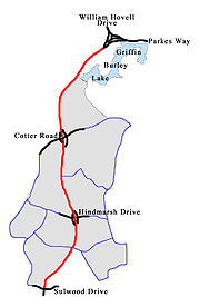
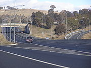
Glenloch Interchange is Canberra's only major interchange which connects Tuggeranong Parkway with Parkes Way, William Hovell Drive and Caswell Drive . Following a major reconstruction lasting from 2007 to mid 2008, the interchange now operates without traffic lights...
, where roads such as Caswell Drive connect to Belconnen
Belconnen, Australian Capital Territory
Belconnen is a suburb of Canberra, Australia in the district of Belconnen. It contains the Belconnen Town Centre, Lake Ginninderra and several residential areas. It is bounded by Ginninderra Drive, Aikman Drive, Eastern Valley Way, Belconnen Way and Coulter Drive...
.
History, Planning and Structure
The Tuggeranong Parkway is 4 lanes wide, has a speed limit of 100 km/h, and is divided variously by a concrete wall or large median strip planted with trees. Four speed cameras were installed on the road in July 2007 to enforce the 100km/h speed limit. They are at the Cotter Road and Hindmarsh Drive interchanges, monitoring both directions of traffic. The road was involved in the Canberra bushfires of 2003 in which the fires came up to the edge of the road and wiped away dense and vast pine plantation forest on the west side of the road.In parts space has been set aside for duplication of the road (to eight lanes) if future needs require it. An example can be seen in the dual road cuttings behind the suburb of Weston.
The Tuggeranong Parkway also connects to the Gungahlin Drive Extension
Gungahlin Drive Extension
The Gungahlin Drive Extension is a major road project in Canberra, Australia. It is 9 kilometres long and extended the previously existing Gungahlin Drive from the Barton Highway in the district of Gungahlin to the Glenloch Interchange to connect with Parkes Way and the Tuggeranong Parkway. The...
, which connects to Belconnen and Gungahlin in the north. In the south it runs onto Drakeford Drive as it enters Kambah. Original plans for the Parkway had it continuing down the route of Kambah Pool Road and crossing the Murrumbidgee River
Murrumbidgee River
The Murrumbidgee River is a major river in the state of New South Wales, Australia, and the Australian Capital Territory . A major tributary of the Murray River, the Murrumbidgee flows in a west-northwesterly direction from the foot of Peppercorn Hill in the Fiery Range of the Snowy Mountains,...
over Red Rocks Gorge to connect suburbs on the west side of the River. Due to the environmental sensitivity of the Murrumbidgee River corridor, especially the Red Rocks Gorge, this plan was cancelled, along with the planned suburbs on the western side of the River.
Connecting Roads
Below is a list of the connecting and exiting roads out of the Tuggeranong Parkway.- Drakeford Drive (Southern Terminus of Tuggeranong Parkway connecting-To TuggeranongTuggeranongTuggeranong is the southernmost town centre of Canberra, the capital city of Australia. It comprises 19 suburbs with a total of 31,819 dwellings, housing 87,119 people of the 324,034 people in the Australian Capital Territory . The district occupies 117 square kilometres to the east of the...
, GordonGordon, Australian Capital TerritoryGordon is a suburb in the Canberra, Australia district of Tuggeranong. The postcode is 2906. The suburb is named after the poet Adam Lindsay Gordon . It was gazetted on 12 March 1987...
and Tharwa) - Sulwood Drive Exit (To East Kambah, Weston CreekWeston CreekWeston Creek is a residential district of Canberra, Australian Capital Territory, Australia, situated to the west of the Woden Valley district and approximately 13 km southwest of the Canberra city centre...
and ChapmanChapman, Australian Capital TerritoryChapman is a suburb of Canberra, Australian Capital Territory, Australia. It is located in the Weston Creek area.The suburb is named after Sir Austin Chapman , Member for Eden-Monaro...
) - Hindmarsh Drive Exit (To WodenWodenWoden or Wodan is a major deity of Anglo-Saxon and Continental Germanic polytheism. Together with his Norse counterpart Odin, Woden represents a development of the Proto-Germanic god *Wōdanaz....
and Weston Creek) - Cotter Road Exit (To Weston, CurtinCurtin, Australian Capital TerritoryCurtin is a suburb in the Canberra, Australia district of Woden. The postcode is 2605.It is next to the suburbs of Yarralumla, Deakin, Hughes, Lyons and Weston...
and DeakinDeakin, Australian Capital TerritoryDeakin is a suburb of Canberra, Australian Capital Territory, Australia. Deakin is named after Alfred Deakin, second prime minister of Australia...
) - Lady Denman Drive Exit (To YarralumlaYarralumla, Australian Capital TerritoryYarralumla is a large inner south suburb of Canberra, the capital city of Australia. Located approximately south-west of the city, Yarralumla extends along the south-west bank of Lake Burley Griffin...
and Central Canberra Suburbs) - William Hovell Drive Exit (To Belconnen SuburbsBelconnen, Australian Capital TerritoryBelconnen is a suburb of Canberra, Australia in the district of Belconnen. It contains the Belconnen Town Centre, Lake Ginninderra and several residential areas. It is bounded by Ginninderra Drive, Aikman Drive, Eastern Valley Way, Belconnen Way and Coulter Drive...
) - Parkes Way (Northern Terminus of Tuggeranong Parkway connecting at Glencloch Interchange-To CityCanberraCanberra is the capital city of Australia. With a population of over 345,000, it is Australia's largest inland city and the eighth-largest city overall. The city is located at the northern end of the Australian Capital Territory , south-west of Sydney, and north-east of Melbourne...
, Airport and Queanbeyan) - Gungahlin Drive ExtensionGungahlin Drive ExtensionThe Gungahlin Drive Extension is a major road project in Canberra, Australia. It is 9 kilometres long and extended the previously existing Gungahlin Drive from the Barton Highway in the district of Gungahlin to the Glenloch Interchange to connect with Parkes Way and the Tuggeranong Parkway. The...
(connecting at Glenloch Interchange-To Belconnen, GungahlinGungahlinGungahlin is a name of a district and the northernmost town centre of Canberra, Australia. Gungahlin is situated 10 km north of Canberra's city centre and is one of five satellites of Canberra including Woden, Tuggeranong, Weston Creek and Belconnen. Currently Gungahlin comprises 11 suburbs,...
and Surrounding Suburbs)
See also
- Freeways in AustraliaFreeways in AustraliaThis is a list of freeways and motorways in Australia, sorted by states and territories and their corresponding routes. This list includes toll roads such as the CityLink freeway system in Melbourne. This list has over 70 entries...
- Freeways in Canberra