
.gif)
Tropical Storm Norman (2000)
Encyclopedia
Tropical Storm Norman was a tropical cyclone
that hit Mexico
in September 2000. The sixteenth cyclone and fourteenth named storm of the 2000 Pacific hurricane season
, Norman originated in a tropical wave
that emerged from the coast of Africa on September 4, and moved westward across the Atlantic Ocean; the wave entered the Pacific on September 16. The disturbance organized into a tropical depression on early on September 20, and later that day the storm reached its peak intensity of 50 mph (85 km/h), and subsequently made landfall to the west of Lázaro Cárdenas, Michoacán
. After weakening to a tropical depression over land, the storm re-emerged over open waters, and made a second landfall before dissipating shortly thereafter. The storm produced heavy rain that resulted in flooding and mudslides, killing about nine people.
that spawned Atlantic Hurricane Gordon
, which emerged off the coast of Africa on September 4. The wave moved westward, with the southern portion of the wave crossing Central America while Gordon formed in the northwest Caribbean Sea. When the wave reached the eastern Pacific Ocean on September 16, it interacted with a pre-existing low-level circulation, which produced a large area of disturbed weather. On September 18, the convection began contracting and organizing, gradually developing a circular area of thunderstorms with well-defined outflow
. It is estimated that at 0000 UTC
on September 20, the system developed into Tropical Depression Sixteen-E, about 205 miles (335 km) south-southeast of Manzanillo
, Colima
.
Upon first becoming a tropical cyclone, the depression was located within an area of weak steering currents. Initially it was forecast to remain offshore; with warm waters and light wind shear
, the depression was forecast to intensify into a strong tropical storm, and possibly attain hurricane status. However, the circulation was difficult to locate, and as such its exact motion was uncertain. Ships in the region confirmed the center of the storm as further northeast than previously thought, but also confirmed tropical storm force winds; as a result, the National Hurricane Center
upgraded the depression to Tropical Storm Norman. Strengthening continued, and Norman attained peak winds of 50 mph (85 km/h), shortly prior to making landfall
west of Lázaro Cárdenas, Michoacán
, late on September 20.
Initially, the storm was forecast to dissipate quickly over land, although the possibility was noted for a westward turn, due to an anticyclone
located over central Mexico. About 10 hours after moving ashore, Norman weakened to tropical depression status, and while moving further inland its track turned to the northwest. The center became very ill-defined over the mountainous terrain of southwest Mexico, although stronger rainbands persisted offshore. Late on September 21, the poorly-defined center of Norman emerged into open waters near Puerto Vallarta, Jalisco, and subsequently turned northward. At first, the depression was forecast to re-intensify into a minimal tropical storm; however, its previous land interaction prevented it from ever re-strengthening. The circulation remained close to the coastline, and at 1500 UTC on September 22, Norman made landfall near Mazatlán
, Sinaloa
, as a weak tropical depression. Within a few hours, the cyclone dissipated over land.
 In response to Norman's upgrade into a tropical storm, a tropical storm warning
was issued for the coast from Zihuatanejo to Manzanillo on September 20. The warning was dropped after Norman made landfall the next day. No additional warnings were issued upon Norman's reemergence over water because it was never expected to restrengthen.
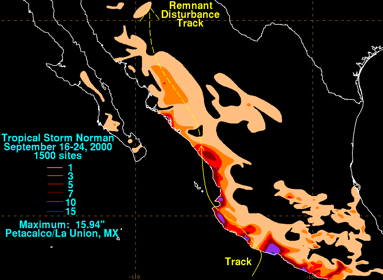
Norman produced heavy rainfall across western Mexico, officially peaking at 14 in (355.6 mm) at Callejones, Colima
. At La Villita, Michoacán
, total rainfall reached 9.5 in (241.3 mm). However, the highest amount was actually at Petacalco/La Union. The rainfall caused severe flooding and mudslides, which killed about nine people. Four of the deaths occurred in the State of Chiapas
as a result of a mudslide. Two more were swept away by raging rivers in the State of Veracruz
, and another two people drowned in the State of Guerrero
. In Chiapas
, authorities evacuated about 300 families due to the flooding.
The name "Norman" was not retired after this storm. It was subsequently reused
in the 2006 season
. It remains on the list for use in 2012.
Tropical cyclone
A tropical cyclone is a storm system characterized by a large low-pressure center and numerous thunderstorms that produce strong winds and heavy rain. Tropical cyclones strengthen when water evaporated from the ocean is released as the saturated air rises, resulting in condensation of water vapor...
that hit Mexico
Mexico
The United Mexican States , commonly known as Mexico , is a federal constitutional republic in North America. It is bordered on the north by the United States; on the south and west by the Pacific Ocean; on the southeast by Guatemala, Belize, and the Caribbean Sea; and on the east by the Gulf of...
in September 2000. The sixteenth cyclone and fourteenth named storm of the 2000 Pacific hurricane season
2000 Pacific hurricane season
The 2000 Pacific hurricane season was an event in tropical cyclone meteorology. There were few notable storms this year. Tropical Storms Miriam, Norman, and Rosa all made landfall in Mexico with minimal impact. Hurricane Daniel briefly threatened the U.S. state of Hawaii while weakening...
, Norman originated in a tropical wave
Tropical wave
Tropical waves, easterly waves, or tropical easterly waves, also known as African easterly waves in the Atlantic region, are a type of atmospheric trough, an elongated area of relatively low air pressure, oriented north to south, which move from east to west across the tropics causing areas of...
that emerged from the coast of Africa on September 4, and moved westward across the Atlantic Ocean; the wave entered the Pacific on September 16. The disturbance organized into a tropical depression on early on September 20, and later that day the storm reached its peak intensity of 50 mph (85 km/h), and subsequently made landfall to the west of Lázaro Cárdenas, Michoacán
Lázaro Cárdenas, Michoacán
Lázaro Cárdenas is a port city that with its surrounding municipality is located in the southern part of the Mexican state of Michoacán. It was formerly known as Los Llanitos, but changed its name as a tribute to Lázaro Cárdenas del Río, a Michoacán-born politician who was president of Mexico from...
. After weakening to a tropical depression over land, the storm re-emerged over open waters, and made a second landfall before dissipating shortly thereafter. The storm produced heavy rain that resulted in flooding and mudslides, killing about nine people.
Meteorological history
The origins of Tropical Storm Norman were from the same tropical waveTropical wave
Tropical waves, easterly waves, or tropical easterly waves, also known as African easterly waves in the Atlantic region, are a type of atmospheric trough, an elongated area of relatively low air pressure, oriented north to south, which move from east to west across the tropics causing areas of...
that spawned Atlantic Hurricane Gordon
Hurricane Gordon (2000)
Hurricane Gordon was one of two U.S. landfalling tropical storms of the 2000 Atlantic hurricane season, and was the 7th named storm and 4th hurricane of the 2000 Atlantic hurricane season. Gordon was a category 1 hurricane over the Gulf of Mexico but weakened to a tropical storm before making...
, which emerged off the coast of Africa on September 4. The wave moved westward, with the southern portion of the wave crossing Central America while Gordon formed in the northwest Caribbean Sea. When the wave reached the eastern Pacific Ocean on September 16, it interacted with a pre-existing low-level circulation, which produced a large area of disturbed weather. On September 18, the convection began contracting and organizing, gradually developing a circular area of thunderstorms with well-defined outflow
Outflow (meteorology)
Outflow, in meteorology, is air that flows outwards from a storm system. It is associated with ridging, or anticyclonic flow. In the low levels of the troposphere, outflow radiates from thunderstorms in the form of a wedge of rain-cooled air, which is visible as a thin rope-like cloud on weather...
. It is estimated that at 0000 UTC
Coordinated Universal Time
Coordinated Universal Time is the primary time standard by which the world regulates clocks and time. It is one of several closely related successors to Greenwich Mean Time. Computer servers, online services and other entities that rely on having a universally accepted time use UTC for that purpose...
on September 20, the system developed into Tropical Depression Sixteen-E, about 205 miles (335 km) south-southeast of Manzanillo
Manzanillo, Colima
The name Manzanillo refers to the city as well as its surrounding municipality in the Mexican state of Colima. The city, located on the Pacific Ocean, contains Mexico's busiest port. Manzanillo was the third port created by the Spanish in the Pacific during the New Spain period...
, Colima
Colima
Colima is one of the 31 states which, with the Federal District, make up the 32 Federal Entities of Mexico. It shares its name with its capital and main city, Colima....
.
Upon first becoming a tropical cyclone, the depression was located within an area of weak steering currents. Initially it was forecast to remain offshore; with warm waters and light wind shear
Wind shear
Wind shear, sometimes referred to as windshear or wind gradient, is a difference in wind speed and direction over a relatively short distance in the atmosphere...
, the depression was forecast to intensify into a strong tropical storm, and possibly attain hurricane status. However, the circulation was difficult to locate, and as such its exact motion was uncertain. Ships in the region confirmed the center of the storm as further northeast than previously thought, but also confirmed tropical storm force winds; as a result, the National Hurricane Center
National Hurricane Center
The National Hurricane Center , located at Florida International University in Miami, Florida, is the division of the National Weather Service responsible for tracking and predicting weather systems within the tropics between the Prime Meridian and the 140th meridian west poleward to the 30th...
upgraded the depression to Tropical Storm Norman. Strengthening continued, and Norman attained peak winds of 50 mph (85 km/h), shortly prior to making landfall
Landfall (meteorology)
Landfall is the event of a tropical cyclone or a waterspout coming onto land after being over water. When a waterspout makes landfall it is reclassified as a tornado, which can then cause damage inland...
west of Lázaro Cárdenas, Michoacán
Lázaro Cárdenas, Michoacán
Lázaro Cárdenas is a port city that with its surrounding municipality is located in the southern part of the Mexican state of Michoacán. It was formerly known as Los Llanitos, but changed its name as a tribute to Lázaro Cárdenas del Río, a Michoacán-born politician who was president of Mexico from...
, late on September 20.
Initially, the storm was forecast to dissipate quickly over land, although the possibility was noted for a westward turn, due to an anticyclone
Anticyclone
An anticyclone is a weather phenomenon defined by the United States' National Weather Service's glossary as "[a] large-scale circulation of winds around a central region of high atmospheric pressure, clockwise in the Northern Hemisphere, counterclockwise in the Southern Hemisphere"...
located over central Mexico. About 10 hours after moving ashore, Norman weakened to tropical depression status, and while moving further inland its track turned to the northwest. The center became very ill-defined over the mountainous terrain of southwest Mexico, although stronger rainbands persisted offshore. Late on September 21, the poorly-defined center of Norman emerged into open waters near Puerto Vallarta, Jalisco, and subsequently turned northward. At first, the depression was forecast to re-intensify into a minimal tropical storm; however, its previous land interaction prevented it from ever re-strengthening. The circulation remained close to the coastline, and at 1500 UTC on September 22, Norman made landfall near Mazatlán
Mazatlán
Mazatlán is a city in the Mexican state of Sinaloa; the surrounding municipio for which the city serves as the municipal seat is Mazatlán Municipality. It is located at on the Pacific coast, across from the southernmost tip of the Baja California peninsula.Mazatlán is a Nahuatl word meaning...
, Sinaloa
Sinaloa
Sinaloa officially Estado Libre y Soberano de Sinaloa is one of the 31 states which, with the Federal District, comprise the 32 Federal Entities of Mexico. It is divided in 18 municipalities and its capital city is Culiacán Rosales....
, as a weak tropical depression. Within a few hours, the cyclone dissipated over land.
Impact and preparations
Tropical cyclone warnings and watches
Warnings and watches are two levels of alert issued by national weather forecasting bodies to coastal areas threatened by the imminent approach of a tropical cyclone of tropical storm or hurricane intensity. They are notices to the local population and civil authorities to make appropriate...
was issued for the coast from Zihuatanejo to Manzanillo on September 20. The warning was dropped after Norman made landfall the next day. No additional warnings were issued upon Norman's reemergence over water because it was never expected to restrengthen.
Norman produced heavy rainfall across western Mexico, officially peaking at 14 in (355.6 mm) at Callejones, Colima
Colima
Colima is one of the 31 states which, with the Federal District, make up the 32 Federal Entities of Mexico. It shares its name with its capital and main city, Colima....
. At La Villita, Michoacán
Michoacán
Michoacán officially Estado Libre y Soberano de Michoacán de Ocampo is one of the 31 states which, with the Federal District, comprise the 32 Federal Entities of Mexico. It is divided in 113 municipalities and its capital city is Morelia...
, total rainfall reached 9.5 in (241.3 mm). However, the highest amount was actually at Petacalco/La Union. The rainfall caused severe flooding and mudslides, which killed about nine people. Four of the deaths occurred in the State of Chiapas
Chiapas
Chiapas officially Estado Libre y Soberano de Chiapas is one of the 31 states that, with the Federal District, comprise the 32 Federal Entities of Mexico. It is divided in 118 municipalities and its capital city is Tuxtla Gutierrez. Other important cites in Chiapas include San Cristóbal de las...
as a result of a mudslide. Two more were swept away by raging rivers in the State of Veracruz
Veracruz
Veracruz, formally Veracruz de Ignacio de la Llave officially Estado Libre y Soberano de Veracruz de Ignacio de la Llave , is one of the 31 states that, along with the Federal District, comprise the 32 federative entities of Mexico. It is divided in 212 municipalities and its capital city is...
, and another two people drowned in the State of Guerrero
Guerrero
Guerrero officially Estado Libre y Soberano de Guerrero is one of the 31 states which, with the Federal District, comprise the 32 Federal Entities of Mexico. It is divided in 81 municipalities and its capital city is Chilpancingo....
. In Chiapas
Chiapas
Chiapas officially Estado Libre y Soberano de Chiapas is one of the 31 states that, with the Federal District, comprise the 32 Federal Entities of Mexico. It is divided in 118 municipalities and its capital city is Tuxtla Gutierrez. Other important cites in Chiapas include San Cristóbal de las...
, authorities evacuated about 300 families due to the flooding.
The name "Norman" was not retired after this storm. It was subsequently reused
Tropical Storm Norman (2006)
Tropical Storm Norman was a weak tropical cyclone that brought heavy rainfall to southwestern Mexico in October 2006. The twelfth named storm of the 2006 Pacific hurricane season, Norman developed on October 9 from a tropical wave well to the southwest of Mexico...
in the 2006 season
2006 Pacific hurricane season
The 2006 Pacific hurricane season was the most active Pacific hurricane season since 2000 producing 19 tropical storms or hurricanes. Eighteen developed within the National Hurricane Center area of warning responsibility, which is east of 140ºW, and one storm formed between 140ºW and the...
. It remains on the list for use in 2012.