
Tropical Storm Dongo
Encyclopedia
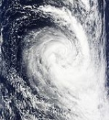
Severe Tropical Storm Dongo (Joint Typhoon Warning Center
designation: 06S) was the fifth tropical disturbance and fourth named storm of the 2008–09 South-West Indian Ocean cyclone season. Dongo developed out of an area of low pressure
near the remnants of Severe Tropical Cyclone Billy early on January 7. The low was quickly declared a tropical disturbance later that day, and a tropical depression the following day. Shortly after being declared a tropical depression, it was further upgraded to a moderate tropical storm and given the name Dongo. Convection
associated with Dongo decreased as it began to exhibit hybrid features
. Late on January 10, convection quickly increased and Dongo intensified into a severe tropical storm early the next morning. Upon becoming a severe tropical storm, Dongo reached its peak intensity with winds of 95 km/h (60 mph 10-minute winds). Despite approaching cooler waters, the storm remained a severe tropical storm until transitioning into an extratropical cyclone
early on January 12. The extratropical remnants of Dongo persisted for another two days before becoming non-tropical.
which developed near the remnants of Severe Tropical Cyclone Billy late on January 7. The low, located within a strong monsoon
al flow, quickly developed poleward outflow
. At 06:00 UTC
, the Regional Specialized Meteorological Centre
(RSMC) Météo-France
designated it as Zone of Disturbed Weather 05-20082009 while located 1,530 km (950 mi) northeast of Mauritius
. Shortly after, the Joint Typhoon Warning Center
(JTWC) determined the chances of a significant tropical cyclone developing within 48 hours as fair. This was based on winds up to 65 km/h (40 mph) derived from QuickSCAT satellite estimates and a continuing development of the structure. However, strong wind shear
was expected to inhibit short term development. A few hours later, Météo-France further upgraded the low to a tropical disturbance as deep convection persisted around the center of circulation
. At 15:00 UTC, the JTWC issued a Tropical Cyclone Formation Alert
, as the low was likely to intensify into a tropical storm. At this time, One-minute sustained winds were estimated at 55 km/h (35 mph).
Situated along the edge of a low-mid level ridge
, the disturbance tracked towards the southwest. Convection diminished slightly later that day due to the shear. At 06:00 UTC on January 9, Météo-France upgraded the disturbance to a tropical depression as convection began to redevelop. Shortly after, the depression was upgraded to Moderate Tropical Storm Dongo as winds were estimated to have reached 75 km/h (45 mph 10-minute winds). At the time of the upgrade, Dongo began to turn more towards the south. Decreasing wind shear and high seas surface temperatures, both necessary factors for intensification, were present and further development of the storm was anticipated. Roughly three hours later, the JTWC began issuing advisories on Tropical Cyclone 06S (Dongo). Deep convection continued to develop around the center, signifying intensification. Slight weakening occurred early on January 10 as the center of circulation relocated to the northwest of the original center. As Dongo began to turn towards the southeast, convection rapidly decreased, leaving the center partially exposed. At this time, Dongo was exhibiting hybrid features
(those of tropical and subtropical cyclones) despite conditions remaining favourable for intensification.
By 18:00 UTC, convection began to increase, and six hours later, Dongo intensified into a severe tropical storm. At this time, Dongo reached its peak intensity with winds of 95 km/h (60 mph 10-minute winds) with a minimum pressure of 984 hPa
(mbar
) according to Météo-France and 100 km/h (65 mph 1-minute winds) according to the JTWC. At this time, Dongo was located about 1,240 km (770 mi) east-southeast of Mauritius. Tracking towards the south-southeast, Dongo approached cooler waters and began to transition into an extratropical cyclone
. Wind shear was also increasing over the storm in response to an approaching upper-level trough
. Despite moving over cooler waters, the storm remained a severe tropical storm until being declared extratropical at 06:00 UTC on January 12. Several hours later, the JTWC issued their final advisory on Ex-Tropical Cyclone 06S (Dongo). Early on January 13, Météo-France issued their final advisory on the extratropical remnants of Dongo. Around 00:00 UTC on January 14, Dongo passed within 190 km (120 mi) of Île Amsterdam
. In the operational best track supplied by Météo-France, it was discovered that Dongo remained extratropical for an additional day, reaching its secondary peak with winds of 110 km/h (70 mph) and a minimum pressure of 978 hPa (mbar) around 12:00 UTC on January 14 shortly before becoming non-tropical.
Joint Typhoon Warning Center
The Joint Typhoon Warning Center is a joint United States Navy – United States Air Force task force located at the Naval Maritime Forecast Center in Pearl Harbor, Hawaii...
designation: 06S) was the fifth tropical disturbance and fourth named storm of the 2008–09 South-West Indian Ocean cyclone season. Dongo developed out of an area of low pressure
Low pressure area
A low-pressure area, or "low", is a region where the atmospheric pressure at sea level is below that of surrounding locations. Low-pressure systems form under areas of wind divergence which occur in upper levels of the troposphere. The formation process of a low-pressure area is known as...
near the remnants of Severe Tropical Cyclone Billy early on January 7. The low was quickly declared a tropical disturbance later that day, and a tropical depression the following day. Shortly after being declared a tropical depression, it was further upgraded to a moderate tropical storm and given the name Dongo. Convection
Atmospheric convection
Atmospheric convection is the result of a parcel-environment instability, or temperature difference, layer in the atmosphere. Different lapse rates within dry and moist air lead to instability. Mixing of air during the day which expands the height of the planetary boundary layer leads to...
associated with Dongo decreased as it began to exhibit hybrid features
Subtropical cyclone
A subtropical cyclone is a weather system that has some characteristics of a tropical and an extratropical cyclone. As early as the 1950s, meteorologists were unclear whether they should be characterized as tropical or extratropical cyclones. They were officially recognized by the National...
. Late on January 10, convection quickly increased and Dongo intensified into a severe tropical storm early the next morning. Upon becoming a severe tropical storm, Dongo reached its peak intensity with winds of 95 km/h (60 mph 10-minute winds). Despite approaching cooler waters, the storm remained a severe tropical storm until transitioning into an extratropical cyclone
Extratropical cyclone
Extratropical cyclones, sometimes called mid-latitude cyclones or wave cyclones, are a group of cyclones defined as synoptic scale low pressure weather systems that occur in the middle latitudes of the Earth having neither tropical nor polar characteristics, and are connected with fronts and...
early on January 12. The extratropical remnants of Dongo persisted for another two days before becoming non-tropical.
Meteorological history
The origins of Dongo can be traced back to an area of low pressureLow pressure area
A low-pressure area, or "low", is a region where the atmospheric pressure at sea level is below that of surrounding locations. Low-pressure systems form under areas of wind divergence which occur in upper levels of the troposphere. The formation process of a low-pressure area is known as...
which developed near the remnants of Severe Tropical Cyclone Billy late on January 7. The low, located within a strong monsoon
Monsoon
Monsoon is traditionally defined as a seasonal reversing wind accompanied by corresponding changes in precipitation, but is now used to describe seasonal changes in atmospheric circulation and precipitation associated with the asymmetric heating of land and sea...
al flow, quickly developed poleward outflow
Outflow (meteorology)
Outflow, in meteorology, is air that flows outwards from a storm system. It is associated with ridging, or anticyclonic flow. In the low levels of the troposphere, outflow radiates from thunderstorms in the form of a wedge of rain-cooled air, which is visible as a thin rope-like cloud on weather...
. At 06:00 UTC
Coordinated Universal Time
Coordinated Universal Time is the primary time standard by which the world regulates clocks and time. It is one of several closely related successors to Greenwich Mean Time. Computer servers, online services and other entities that rely on having a universally accepted time use UTC for that purpose...
, the Regional Specialized Meteorological Centre
Regional Specialized Meteorological Centre
A Regional Specialized Meteorological Centre is responsible for the distribution of information, advisories, and warnings regarding the specific program they have a part of, agreed by consensus at the World Meteorological Organization as part of the World Weather Watch.-Tropical...
(RSMC) Météo-France
Météo-France
Météo-France is the French national meteorological service.The organisation was established by decree in June 1993 and is a department of the Ministry of Transportation. It is headquartered in Paris but many domestic operations have been decentralised to Toulouse...
designated it as Zone of Disturbed Weather 05-20082009 while located 1,530 km (950 mi) northeast of Mauritius
Mauritius
Mauritius , officially the Republic of Mauritius is an island nation off the southeast coast of the African continent in the southwest Indian Ocean, about east of Madagascar...
. Shortly after, the Joint Typhoon Warning Center
Joint Typhoon Warning Center
The Joint Typhoon Warning Center is a joint United States Navy – United States Air Force task force located at the Naval Maritime Forecast Center in Pearl Harbor, Hawaii...
(JTWC) determined the chances of a significant tropical cyclone developing within 48 hours as fair. This was based on winds up to 65 km/h (40 mph) derived from QuickSCAT satellite estimates and a continuing development of the structure. However, strong wind shear
Wind shear
Wind shear, sometimes referred to as windshear or wind gradient, is a difference in wind speed and direction over a relatively short distance in the atmosphere...
was expected to inhibit short term development. A few hours later, Météo-France further upgraded the low to a tropical disturbance as deep convection persisted around the center of circulation
Eye (cyclone)
The eye is a region of mostly calm weather found at the center of strong tropical cyclones. The eye of a storm is a roughly circular area and typically 30–65 km in diameter. It is surrounded by the eyewall, a ring of towering thunderstorms where the second most severe weather of a cyclone...
. At 15:00 UTC, the JTWC issued a Tropical Cyclone Formation Alert
Tropical Cyclone Formation Alert
A Tropical Cyclone Formation Alert is a bulletin released by the U.S. Navy-operated Joint Typhoon Warning Center in Honolulu, Hawaii or the Naval Maritime Forecast Center in Norfolk, Virginia, warning of the possibility of a tropical cyclone forming from a tropical disturbance that has been...
, as the low was likely to intensify into a tropical storm. At this time, One-minute sustained winds were estimated at 55 km/h (35 mph).
Situated along the edge of a low-mid level ridge
High pressure area
A high-pressure area is a region where the atmospheric pressure at the surface of the planet is greater than its surrounding environment. Winds within high-pressure areas flow outward due to the higher density air near their center and friction with land...
, the disturbance tracked towards the southwest. Convection diminished slightly later that day due to the shear. At 06:00 UTC on January 9, Météo-France upgraded the disturbance to a tropical depression as convection began to redevelop. Shortly after, the depression was upgraded to Moderate Tropical Storm Dongo as winds were estimated to have reached 75 km/h (45 mph 10-minute winds). At the time of the upgrade, Dongo began to turn more towards the south. Decreasing wind shear and high seas surface temperatures, both necessary factors for intensification, were present and further development of the storm was anticipated. Roughly three hours later, the JTWC began issuing advisories on Tropical Cyclone 06S (Dongo). Deep convection continued to develop around the center, signifying intensification. Slight weakening occurred early on January 10 as the center of circulation relocated to the northwest of the original center. As Dongo began to turn towards the southeast, convection rapidly decreased, leaving the center partially exposed. At this time, Dongo was exhibiting hybrid features
Subtropical cyclone
A subtropical cyclone is a weather system that has some characteristics of a tropical and an extratropical cyclone. As early as the 1950s, meteorologists were unclear whether they should be characterized as tropical or extratropical cyclones. They were officially recognized by the National...
(those of tropical and subtropical cyclones) despite conditions remaining favourable for intensification.
By 18:00 UTC, convection began to increase, and six hours later, Dongo intensified into a severe tropical storm. At this time, Dongo reached its peak intensity with winds of 95 km/h (60 mph 10-minute winds) with a minimum pressure of 984 hPa
Pascal (unit)
The pascal is the SI derived unit of pressure, internal pressure, stress, Young's modulus and tensile strength, named after the French mathematician, physicist, inventor, writer, and philosopher Blaise Pascal. It is a measure of force per unit area, defined as one newton per square metre...
(mbar
Bar (unit)
The bar is a unit of pressure equal to 100 kilopascals, and roughly equal to the atmospheric pressure on Earth at sea level. Other units derived from the bar are the megabar , kilobar , decibar , centibar , and millibar...
) according to Météo-France and 100 km/h (65 mph 1-minute winds) according to the JTWC. At this time, Dongo was located about 1,240 km (770 mi) east-southeast of Mauritius. Tracking towards the south-southeast, Dongo approached cooler waters and began to transition into an extratropical cyclone
Extratropical cyclone
Extratropical cyclones, sometimes called mid-latitude cyclones or wave cyclones, are a group of cyclones defined as synoptic scale low pressure weather systems that occur in the middle latitudes of the Earth having neither tropical nor polar characteristics, and are connected with fronts and...
. Wind shear was also increasing over the storm in response to an approaching upper-level trough
Trough (meteorology)
A trough is an elongated region of relatively low atmospheric pressure, often associated with fronts.Unlike fronts, there is not a universal symbol for a trough on a weather chart. The weather charts in some countries or regions mark troughs by a line. In the United States, a trough may be marked...
. Despite moving over cooler waters, the storm remained a severe tropical storm until being declared extratropical at 06:00 UTC on January 12. Several hours later, the JTWC issued their final advisory on Ex-Tropical Cyclone 06S (Dongo). Early on January 13, Météo-France issued their final advisory on the extratropical remnants of Dongo. Around 00:00 UTC on January 14, Dongo passed within 190 km (120 mi) of Île Amsterdam
Île Amsterdam
New Amsterdam, Amsterdam Island, or Île Amsterdam is a French island in the Indian Ocean located at . It is part of the French Southern and Antarctic Lands.- History :...
. In the operational best track supplied by Météo-France, it was discovered that Dongo remained extratropical for an additional day, reaching its secondary peak with winds of 110 km/h (70 mph) and a minimum pressure of 978 hPa (mbar) around 12:00 UTC on January 14 shortly before becoming non-tropical.
Impact
As Dongo remained out over open waters for the duration of its existence, there was no impact on any land-masses.See also
- 2008–09 South-West Indian Ocean cyclone season
- Timeline of the 2008–09 South-West Indian Ocean cyclone seasonTimeline of the 2008–09 South-West Indian Ocean cyclone seasonBelow is a timeline of the 2008–09 South-West Indian Ocean cyclone season, documenting storm formations, intensifcation, weakening, landfalls, extratropical transitions, as well as dissipation or leaving the area of responsibility....