
.gif)
Tropical Storm Debby (2006)
Encyclopedia
Tropical Storm Debby was the fifth tropical storm
of the 2006 Atlantic hurricane season
. Debby formed just off the coast of Africa
on August 21 from a tropical wave. After passing near the Cape Verde
islands, Debby moved generally northwestward for much of its life, reaching a peak intensity of 50 mph (85 km/h). Strong wind shear
weakened the storm, and Debby dissipated on August 27 over the northern Atlantic Ocean
.
Early in its life, Debby was forecast to pass through the southern Cape Verde islands as a tropical storm, potentially causing life-threatening flooding. Most computer models consistently predicted Debby to track to the northwest throughout its lifetime, though intensity was more problematic for forecasters. The National Hurricane Center continually predicted Debby to intensify to hurricane status, though strong vertical shear ultimately prevented the storm from becoming a hurricane.
moved off the coast of Africa
late on August 20, and almost immediately developed convective banding and a broad circulation. A broad area of low pressure formed within the wave the next day while located 260 mi (420 km) southeast of the Cape Verde
islands. Though convection decreased early on August 21, the area of low pressure remained well-organized and the system developed into Tropical Depression Four late on August 21. Water temperatures remained warm enough for development, while upper level shear was minimal as the depression moved west-northwestward due to a ridge of high pressure to its north. Initial predictions by the National Hurricane Center also forecast a motion to the northwest based on consistent model predictions, though, as quoted by forecaster James Franklin
, "The models have also been excellently wrong thus far".
Despite a decrease in convection shortly after forming, the large depression remained well organized, with a wind field 575 mi (930 km) in diameter. On August 22, as it passed 140 mi (225 km) to south of the Cape Verde
islands, deep convection developed over the center of circulation, and early on August 23 the depression intensified into Tropical Storm Debby about 300 mi (485 km) southwest of Cape Verde. Banding features continued to organize as the system slowly strengthened, and on August 23 Debby attained a peak intensity of 50 mph (85 km/h) over the open waters of the Atlantic Ocean
. Forecasters predicted Debby to continue to intensify to attain hurricane status, while its projected path placed the storm in an area of warm water temperatures and moderate upper level shear.
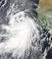
.jpg) Shortly after reaching its peak intensity, Debby encountered an area of dry air, and subsequently weakened. The low level circulation detached itself from the diminishing convection while the system as a whole continued west-northwestward. Convection redeveloped over a portion of the center, while banding features redeveloped as well. Organization continued, and Debby again reached its peak intensity of 50 mph (85 km/h) on August 24. Southerly wind shear
Shortly after reaching its peak intensity, Debby encountered an area of dry air, and subsequently weakened. The low level circulation detached itself from the diminishing convection while the system as a whole continued west-northwestward. Convection redeveloped over a portion of the center, while banding features redeveloped as well. Organization continued, and Debby again reached its peak intensity of 50 mph (85 km/h) on August 24. Southerly wind shear
displaced the convection to the north of the center, and Debby weakened to a minimal tropical storm on August 25. The center of the storm became asymmetric and elongated, and on August 26 Debby weakened to a tropical depression. Convection remained minimal and it quickly degenerated into a remnant area of low pressure. The low turned to the north and north-northeast ahead of an approaching trough
, and on August 28 the low dissipated.
 The government of the Cape Verde
islands issued a tropical storm warning
coinciding with the issuance of the first advisory on Tropical Depression Four, meaning tropical storm conditions were expected in the area within 24 hours. The National Hurricane Center
stated that heavy rainfall, potentially as high as 10 in (250 mm) in mountainous areas, would be possible in the territory, possibly causing life-threatening flash floods and mudslides. However, due to a reformation further to the south, tropical storm warnings were discontinued as the depression moved from the area. While passing around 115 mi (185 km) to the southwest of the southwestern most islands, the depression produced a 35 mph (55 km/h) wind gust at Fogo
and some rainfall, though no damage was reported.
Long range forecasts brought the storm near Bermuda
. However Debby remained over 900 mi (1,450 km) from the island at its closest approach. Though the storm was forecast to remain far away from the Gulf of Mexico
, investors tracking the storm caused the price of crude oil to rise 60 cents a barrel due to the potential impact to oil installations.
Tropical cyclone
A tropical cyclone is a storm system characterized by a large low-pressure center and numerous thunderstorms that produce strong winds and heavy rain. Tropical cyclones strengthen when water evaporated from the ocean is released as the saturated air rises, resulting in condensation of water vapor...
of the 2006 Atlantic hurricane season
2006 Atlantic hurricane season
The 2006 Atlantic hurricane season was significantly less active than the record previous season. It marked the first since 2001 in which no hurricanes made landfall in the United States, and was the first since 1994 that no tropical cyclones formed during October. Following the intense activity of...
. Debby formed just off the coast of Africa
Africa
Africa is the world's second largest and second most populous continent, after Asia. At about 30.2 million km² including adjacent islands, it covers 6% of the Earth's total surface area and 20.4% of the total land area...
on August 21 from a tropical wave. After passing near the Cape Verde
Cape Verde
The Republic of Cape Verde is an island country, spanning an archipelago of 10 islands located in the central Atlantic Ocean, 570 kilometres off the coast of Western Africa...
islands, Debby moved generally northwestward for much of its life, reaching a peak intensity of 50 mph (85 km/h). Strong wind shear
Wind shear
Wind shear, sometimes referred to as windshear or wind gradient, is a difference in wind speed and direction over a relatively short distance in the atmosphere...
weakened the storm, and Debby dissipated on August 27 over the northern Atlantic Ocean
Atlantic Ocean
The Atlantic Ocean is the second-largest of the world's oceanic divisions. With a total area of about , it covers approximately 20% of the Earth's surface and about 26% of its water surface area...
.
Early in its life, Debby was forecast to pass through the southern Cape Verde islands as a tropical storm, potentially causing life-threatening flooding. Most computer models consistently predicted Debby to track to the northwest throughout its lifetime, though intensity was more problematic for forecasters. The National Hurricane Center continually predicted Debby to intensify to hurricane status, though strong vertical shear ultimately prevented the storm from becoming a hurricane.
Meteorological history
A vigorous tropical waveTropical wave
Tropical waves, easterly waves, or tropical easterly waves, also known as African easterly waves in the Atlantic region, are a type of atmospheric trough, an elongated area of relatively low air pressure, oriented north to south, which move from east to west across the tropics causing areas of...
moved off the coast of Africa
Africa
Africa is the world's second largest and second most populous continent, after Asia. At about 30.2 million km² including adjacent islands, it covers 6% of the Earth's total surface area and 20.4% of the total land area...
late on August 20, and almost immediately developed convective banding and a broad circulation. A broad area of low pressure formed within the wave the next day while located 260 mi (420 km) southeast of the Cape Verde
Cape Verde
The Republic of Cape Verde is an island country, spanning an archipelago of 10 islands located in the central Atlantic Ocean, 570 kilometres off the coast of Western Africa...
islands. Though convection decreased early on August 21, the area of low pressure remained well-organized and the system developed into Tropical Depression Four late on August 21. Water temperatures remained warm enough for development, while upper level shear was minimal as the depression moved west-northwestward due to a ridge of high pressure to its north. Initial predictions by the National Hurricane Center also forecast a motion to the northwest based on consistent model predictions, though, as quoted by forecaster James Franklin
James Franklin (meteorologist)
James L. Franklin is a weather forecaster with the National Hurricane Center and its current branch chief. He is a graduate of the Massachusetts Institute of Technology and of Ransom Everglades School in 1976 in Miami, where he was a co-valedictorian....
, "The models have also been excellently wrong thus far".
Despite a decrease in convection shortly after forming, the large depression remained well organized, with a wind field 575 mi (930 km) in diameter. On August 22, as it passed 140 mi (225 km) to south of the Cape Verde
Cape Verde
The Republic of Cape Verde is an island country, spanning an archipelago of 10 islands located in the central Atlantic Ocean, 570 kilometres off the coast of Western Africa...
islands, deep convection developed over the center of circulation, and early on August 23 the depression intensified into Tropical Storm Debby about 300 mi (485 km) southwest of Cape Verde. Banding features continued to organize as the system slowly strengthened, and on August 23 Debby attained a peak intensity of 50 mph (85 km/h) over the open waters of the Atlantic Ocean
Atlantic Ocean
The Atlantic Ocean is the second-largest of the world's oceanic divisions. With a total area of about , it covers approximately 20% of the Earth's surface and about 26% of its water surface area...
. Forecasters predicted Debby to continue to intensify to attain hurricane status, while its projected path placed the storm in an area of warm water temperatures and moderate upper level shear.
Wind shear
Wind shear, sometimes referred to as windshear or wind gradient, is a difference in wind speed and direction over a relatively short distance in the atmosphere...
displaced the convection to the north of the center, and Debby weakened to a minimal tropical storm on August 25. The center of the storm became asymmetric and elongated, and on August 26 Debby weakened to a tropical depression. Convection remained minimal and it quickly degenerated into a remnant area of low pressure. The low turned to the north and north-northeast ahead of an approaching trough
Trough (meteorology)
A trough is an elongated region of relatively low atmospheric pressure, often associated with fronts.Unlike fronts, there is not a universal symbol for a trough on a weather chart. The weather charts in some countries or regions mark troughs by a line. In the United States, a trough may be marked...
, and on August 28 the low dissipated.
Preparation and Impact
Cape Verde
The Republic of Cape Verde is an island country, spanning an archipelago of 10 islands located in the central Atlantic Ocean, 570 kilometres off the coast of Western Africa...
islands issued a tropical storm warning
Tropical cyclone warnings and watches
Warnings and watches are two levels of alert issued by national weather forecasting bodies to coastal areas threatened by the imminent approach of a tropical cyclone of tropical storm or hurricane intensity. They are notices to the local population and civil authorities to make appropriate...
coinciding with the issuance of the first advisory on Tropical Depression Four, meaning tropical storm conditions were expected in the area within 24 hours. The National Hurricane Center
National Hurricane Center
The National Hurricane Center , located at Florida International University in Miami, Florida, is the division of the National Weather Service responsible for tracking and predicting weather systems within the tropics between the Prime Meridian and the 140th meridian west poleward to the 30th...
stated that heavy rainfall, potentially as high as 10 in (250 mm) in mountainous areas, would be possible in the territory, possibly causing life-threatening flash floods and mudslides. However, due to a reformation further to the south, tropical storm warnings were discontinued as the depression moved from the area. While passing around 115 mi (185 km) to the southwest of the southwestern most islands, the depression produced a 35 mph (55 km/h) wind gust at Fogo
Fogo, Cape Verde
Fogo is an island in the Sotavento group of Cape Verde. It is the most prominent of the group, rising to nearly 3,000 m above sea level at Pico do Fogo.-Geography:...
and some rainfall, though no damage was reported.
Long range forecasts brought the storm near Bermuda
Bermuda
Bermuda is a British overseas territory in the North Atlantic Ocean. Located off the east coast of the United States, its nearest landmass is Cape Hatteras, North Carolina, about to the west-northwest. It is about south of Halifax, Nova Scotia, Canada, and northeast of Miami, Florida...
. However Debby remained over 900 mi (1,450 km) from the island at its closest approach. Though the storm was forecast to remain far away from the Gulf of Mexico
Gulf of Mexico
The Gulf of Mexico is a partially landlocked ocean basin largely surrounded by the North American continent and the island of Cuba. It is bounded on the northeast, north and northwest by the Gulf Coast of the United States, on the southwest and south by Mexico, and on the southeast by Cuba. In...
, investors tracking the storm caused the price of crude oil to rise 60 cents a barrel due to the potential impact to oil installations.
See also
- Other storms of the same name