

Trinity Inlet
Encyclopedia
Estuary
An estuary is a partly enclosed coastal body of water with one or more rivers or streams flowing into it, and with a free connection to the open sea....
which serves as the port
Port
A port is a location on a coast or shore containing one or more harbors where ships can dock and transfer people or cargo to or from land....
for the city of Cairns, Queensland
Queensland
Queensland is a state of Australia, occupying the north-eastern section of the mainland continent. It is bordered by the Northern Territory, South Australia and New South Wales to the west, south-west and south respectively. To the east, Queensland is bordered by the Coral Sea and Pacific Ocean...
, Australia
Australia
Australia , officially the Commonwealth of Australia, is a country in the Southern Hemisphere comprising the mainland of the Australian continent, the island of Tasmania, and numerous smaller islands in the Indian and Pacific Oceans. It is the world's sixth-largest country by total area...
. The city centre is on the western bank where the inlet meets the sea.
In prehistoric times, the Trinity Inlet was the river mouth of the Mulgrave River
Mulgrave River
The Mulgrave River is a river in Far North Queensland, Australia. It flows in a northerly direction through Gordonvale and the southern outskirts of Cairns, after rising in the Bellenden Ker Range...
. Volcanic activity resulted in the rise of Green Hill in the Mulgrave Valley, but contrary to popular belief this did not block the river, as sediments continued to build up over the volcanic rocks. The Mulgrave River later shifted course and now empties into the Coral Sea
Coral Sea
The Coral Sea is a marginal sea off the northeast coast of Australia. It is bounded in the west by the east coast of Queensland, thereby including the Great Barrier Reef, in the east by Vanuatu and by New Caledonia, and in the north approximately by the southern extremity of the Solomon Islands...
30 km further south at the southern extremity of the Yarrabah Hills range.
Trinity Inlet is lined with mangrove
Mangrove
Mangroves are various kinds of trees up to medium height and shrubs that grow in saline coastal sediment habitats in the tropics and subtropics – mainly between latitudes N and S...
s and mudflats. Within the inlet a large mud island has been formed and was given the name Admiralty Island. Concerns have been raised about the amount of debris and derelict shipping that exist in the upper regions of the inlet.
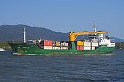
Commercially the inlet provides a limited deep-water berthing for the port of Cairns
Cairns Port Authority
Cairns Port Authority is a Queensland Government statutory Corporation responsible for the operation of the Cairns Seaport. The Authority is also responsible for the Cairns Marlin Marina and the Cityport project. The Seaport and Cityport comprise the authority’s business units.- Cairns Seaport...
, allowing the export of cane sugar
Sugarcane
Sugarcane refers to any of six to 37 species of tall perennial grasses of the genus Saccharum . Native to the warm temperate to tropical regions of South Asia, they have stout, jointed, fibrous stalks that are rich in sugar, and measure two to six metres tall...
. The region's only tanker berth and the Royal Australian Navy base HMAS Cairns
HMAS Cairns (naval base)
HMAS Cairns is a naval base of the Royal Australian Navy located in Cairns, Queensland. Although used regularly as a port-of-call since before World War II, a permanent RAN presence was not established until 1971, when a maintenance and support base for patrol boats was set up...
are located on the inlet. Several shipbuilders and tour operators that visit the Great Barrier Reef
Great Barrier Reef
The Great Barrier Reef is the world'slargest reef system composed of over 2,900 individual reefs and 900 islands stretching for over 2,600 kilometres over an area of approximately...
operate from the Reef Terminal on the entrance to the inlet.
Remnants of a levee
Levee
A levee, levée, dike , embankment, floodbank or stopbank is an elongated naturally occurring ridge or artificially constructed fill or wall, which regulates water levels...
can be found on the eastern bank opposite Cairns. This was an effort by CSR in the 1970s to cultivate sugar cane on mostly intertidal land previously occupied by mangroves and saltmarsh. This was not successful due to the disturbance of a large area of acid sulfate soil. Discharge of sulfuric acid into Trinity inlet from this land resulted in a number of fish kills. In recent years, the Queensland Government has untertaken a major remediation project to prevent the acid discharge and rehabilitate the land behind the levee.
The inlet offers shelter to small vessels when Tropical cyclones threaten. A commercial Saltwater Crocodile
Saltwater Crocodile
The saltwater crocodile, also known as estuarine or Indo-Pacific crocodile, is the largest of all living reptiles...
farm is in operation on the upper reaches, though wild examples are still very rare in the area after hunting in the early 20th century.