
Trent-Severn Waterway
Encyclopedia
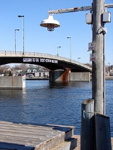
The Trent–Severn Waterway is a Canadian
canal
system formerly used for industrial and transportation purposes and now for recreational and tourism purposes, connecting Lake Ontario
at Trenton
to the Georgian Bay
portion of Lake Huron
at Port Severn. Its major natural waterways include the Trent River
, Otonabee River
, the Kawartha lakes, Lake Simcoe
, Lake Couchiching
and the Severn River
.
It traverses Southern Ontario
's "cottage country
", where recreational properties are the primary industry along the waterway. It is open for navigation from May until October.
The Waterway is a National Historic Site of Canada, administered by Parks Canada
.
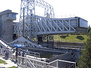
at Peterborough
and Kirkfield
, and a marine railway at Big Chute
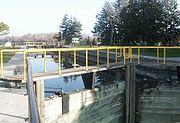
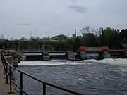
which transports boats between the upper and lower sections of the Severn. The system also includes 39 swing bridges and 160 dams and control structures that manage the water levels for flood control and navigation on lakes and rivers that drain approximately 18600 square kilometres (7,182 sq mi) of central Ontario's cottage country region, across four counties and three single-tier cities, an area that is home to more than a million Canadians.
It reaches its highest point of 256.3 metre at Balsam Lake
, the highest point to which a vessel can be navigated from sea level in the Great Lakes
-Saint Lawrence River
drainage basin
. The navigable summit of the Monongahela River
(part of the Mississippi River
drainage basin) at Fairmont, West Virginia
is, at 263 metre, the highest point in North America, and the summit of the Rhine–Main–Danube Canal at its highest point of 406 metre is higher still.
The Trent–Severn Waterway is managed by Parks Canada
under the statutory authority of the Historic Canals Regulations (which outline and delegate the responsibilities for navigation, resource protection, dredge and fill operations, the operation of boater campgrounds, etc.). The 386-kilometre navigation corridor includes over 4500 kilometres (2,796 mi) of shoreline and over 500 square kilometres (193 sq mi) of water. More than private and commercial properties abut the navigation corridor of the Trent–Severn Waterway. The Trent–Severn Waterway also has regulatory responsibility and authority under the Dominion Water Power Act for the 18 hydroelectric generating facilities located along its route.
A six-member independent panel was appointed to evaluate the waterway's future in May 2007. The panel members heard from more than one thousand people in more than thirty meetings in sixteen communities along the waterway. The panel submitted their report to the Federal Minister of the Environment in April 2008.
 Samuel Champlain was the first European to travel the network of inland waters from Georgian Bay to the Bay of Quinte with the Hurons in 1615. A route that would later be canalized and named the Trent-Severn Waterway.
In the mid-19th century,the river systems of Central Ontario were used by lumber barons to easily transport newly felled trees to sawmills closer to market. Many of the logging companies opposed the building of locks, for these would interfere with their business interests. The logging companies did, however, help to create thriving communities such as Bobcaygeon
and Fenelon Falls
, all of which helped to delay the building of the lock system.
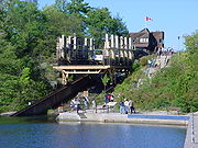
Construction began in the Kawartha Lakes region in 1833 with the Lock at Bobcaygeon marking its beginning. It took over 87 years to complete the waterway with two "temporary" marine railways installed at Big Chute and Swift Rapids. Only by 1920 could a boat travel the whole route. Some argue that the canal has not been finished. Although the Swift Rapids Marine Railway was replaced by the intended conventional lock
installed in 1965, the Big Chute Marine Railway
is still in operation, with early plans for a lock to replace it being abandoned. Lock 45 at Port Severn was completed in a hurry under political pressure to complete the system and is undersized to this day in comparison to the length and width of the other conventional lock stations on the system. A branch of the canal constructed to Newmarket, Ontario
was abandoned during construction and never completed. An alternate route to Georgian Bay via Kempenfelt Bay and the Nottawasaga River exiting at Wasaga Beach was also briefly contemplated as an alternate to the Severn River route that was finally adopted. It was also contemplated that the canal would join to Georgian Bay via Honey Harbour with a lock between Little Go Home Bay and Baxter Lake
The slow progress was noticed by the Canadian government. In 1878 Prime Minister Sir John A. Macdonald
tried to speed up progress by making it government policy to ensure that the system would be completed. To realize some of the economic benefits of a complete canal system, the Government of Ontario built some of the locks before the Federal government resumed construction. Despite this, the canal entered a period of slow growth between 1875 and 1900. Travel was blocked beyond Balsam Lake
until the opening of the Kirkfield Lift Lock
in 1907.
The lock system aided the development of central Ontario, allowing a quick and efficient flow of goods to and from the major trading centres along Lake Ontario. The rugged, rough terrain of this area of the province made travel by land extremely difficult and time-consuming.
When the canal was finally completed, it failed to have a major impact on the economy of the regions it was built to serve. By the time it was completed its design had been made obsolete by larger boats: it had been designed for boats too small to be commercially viable. In the years that it was under construction, railways had further developed their networks and improved service, which influenced settlement patterns.
The waterway became completely obsolete for commercial purposes when the present day Welland Canal
was completed in 1932. The Welland Canal could handle ships large enough to sail across the ocean, though cargo was generally transferred to or from larger ocean-going vessels at Montreal.
The Trent-Severn system is still in service. It is maintained and operated by the national park service, Parks Canada
, and now is used for tourism
and by recreational boaters. There is a cruise line that operates the ship Kawartha Voyageur, as well as houseboat
rental firms.
Canada
Canada is a North American country consisting of ten provinces and three territories. Located in the northern part of the continent, it extends from the Atlantic Ocean in the east to the Pacific Ocean in the west, and northward into the Arctic Ocean...
canal
Canal
Canals are man-made channels for water. There are two types of canal:#Waterways: navigable transportation canals used for carrying ships and boats shipping goods and conveying people, further subdivided into two kinds:...
system formerly used for industrial and transportation purposes and now for recreational and tourism purposes, connecting Lake Ontario
Lake Ontario
Lake Ontario is one of the five Great Lakes of North America. It is bounded on the north and southwest by the Canadian province of Ontario, and on the south by the American state of New York. Ontario, Canada's most populous province, was named for the lake. In the Wyandot language, ontarío means...
at Trenton
Trenton, Ontario
Trenton is a community in Southern Ontario in the municipality of Quinte West, Ontario, Canada. Located on the Bay of Quinte, it is the main population centre in Quinte West....
to the Georgian Bay
Georgian Bay
Georgian Bay is a large bay of Lake Huron, located entirely within Ontario, Canada...
portion of Lake Huron
Lake Huron
Lake Huron is one of the five Great Lakes of North America. Hydrologically, it comprises the larger portion of Lake Michigan-Huron. It is bounded on the east by the Canadian province of Ontario and on the west by the state of Michigan in the United States...
at Port Severn. Its major natural waterways include the Trent River
Trent River (Ontario)
The Trent River is a river in southeastern Ontario which flows from Rice Lake to empty into the Bay of Quinte on Lake Ontario. This river is part of the Trent-Severn Waterway which leads to Georgian Bay. The river is 90 km long...
, Otonabee River
Otonabee River
The Otonabee River is a river that runs from Katchewanooka Lake near Lakefield, into the east side of Peterborough, Ontario , through Little Lake and down 30 km into the northwestern side of Rice Lake...
, the Kawartha lakes, Lake Simcoe
Lake Simcoe
Lake Simcoe is a lake in Southern Ontario, Canada, the fourth-largest lake wholly in the province, after Lake Nipigon, Lac Seul, and Lake Nipissing. At the time of the first European contact in the 17th century the lake was called Ouentironk by the Huron natives...
, Lake Couchiching
Lake Couchiching
Lake Couchiching, from the Ojibwe gojijiing meaning "inlet", is a small lake in Central Ontario separated from Lake Simcoe by a narrow channel. The Trent-Severn Waterway enters Lake Simcoe by the Talbot River and exits this lake by the Severn River which empties into Georgian Bay...
and the Severn River
Severn River (central Ontario)
The Severn River is a river in central Ontario, Canada. Its headwaters are located at the north end of Lake Couchiching. It drains Lake Couchiching and Lake Simcoe...
.
It traverses Southern Ontario
Southern Ontario
Southern Ontario is a region of the province of Ontario, Canada that lies south of the French River and Algonquin Park. Depending on the inclusion of the Parry Sound and Muskoka districts, its surface area would cover between 14 to 15% of the province. It is the southernmost region of...
's "cottage country
Cottage country
Cottage country is a common name in Eastern Canada for areas that are popular locations for recreational properties such as cottages and summer homes. The name is often applied locally; that is, any major population centre may have its own popular "cottage country" area...
", where recreational properties are the primary industry along the waterway. It is open for navigation from May until October.
The Waterway is a National Historic Site of Canada, administered by Parks Canada
Parks Canada
Parks Canada , also known as the Parks Canada Agency , is an agency of the Government of Canada mandated to protect and present nationally significant natural and cultural heritage, and foster public understanding, appreciation, and enjoyment in ways that ensure their ecological and commemorative...
.
Geography
The total length of the waterway is 386 kilometres (240 mi), beginning at Trenton, Ontario, with roughly 32 kilometres (20 mi) of man-made channels. There are 45 locks, including 36 conventional locks, two sets of flight locks, hydraulic lift locksBoat lift
A boat lift, ship lift, or lift lock is a machine for transporting boats between water at two different elevations, and is an alternative to the canal lock and the canal inclined plane....
at Peterborough
Peterborough, Ontario
Peterborough is a city on the Otonabee River in southern Ontario, Canada, 125 kilometres northeast of Toronto. The population of the City of Peterborough was 74,898 as of the 2006 census, while the census metropolitan area has a population of 121,428 as of a 2009 estimate. It presently ranks...
and Kirkfield
Kirkfield, Ontario
Kirkfield is a village located in the city of Kawartha Lakes, in the Canadian province of Ontario. The unincorporated village was named in 1864 after the initial name, Novar, was rejected by the government. A list of 8 possible choices was then offered. The village, being predominantly Scottish at...
, and a marine railway at Big Chute
Big Chute Marine Railway
Big Chute Marine Railway is a boat lift at Lock 44 of the Trent-Severn Waterway in Ontario, Canada. It works on an inclined plane to carry boats in individual cradles over a change of height of about...
which transports boats between the upper and lower sections of the Severn. The system also includes 39 swing bridges and 160 dams and control structures that manage the water levels for flood control and navigation on lakes and rivers that drain approximately 18600 square kilometres (7,182 sq mi) of central Ontario's cottage country region, across four counties and three single-tier cities, an area that is home to more than a million Canadians.
It reaches its highest point of 256.3 metre at Balsam Lake
Balsam Lake (Ontario)
Balsam Lake is a lake located in the Kawartha lakes region of south central Ontario, Canada. It is 16 km long and averages 3 km wide, though its actual width varies due to the many large bays the carve its shoreline...
, the highest point to which a vessel can be navigated from sea level in the Great Lakes
Great Lakes Basin
The Great Lakes Basin consists of the Great Lakes and the surrounding lands of the states of Illinois, Indiana, Michigan, Minnesota, New York, Ohio, Pennsylvania, and Wisconsin in the United States, and the province of Ontario in Canada, whose direct surface runoff and watersheds form a large...
-Saint Lawrence River
Saint Lawrence River
The Saint Lawrence is a large river flowing approximately from southwest to northeast in the middle latitudes of North America, connecting the Great Lakes with the Atlantic Ocean. It is the primary drainage conveyor of the Great Lakes Basin...
drainage basin
Drainage basin
A drainage basin is an extent or an area of land where surface water from rain and melting snow or ice converges to a single point, usually the exit of the basin, where the waters join another waterbody, such as a river, lake, reservoir, estuary, wetland, sea, or ocean...
. The navigable summit of the Monongahela River
Monongahela River
The Monongahela River is a river on the Allegheny Plateau in north-central West Virginia and southwestern Pennsylvania in the United States...
(part of the Mississippi River
Mississippi River
The Mississippi River is the largest river system in North America. Flowing entirely in the United States, this river rises in western Minnesota and meanders slowly southwards for to the Mississippi River Delta at the Gulf of Mexico. With its many tributaries, the Mississippi's watershed drains...
drainage basin) at Fairmont, West Virginia
Fairmont, West Virginia
Fairmont is a city in Marion County, West Virginia, United States. Nicknamed "The Friendly City". The population was 18,704 at the 2010 census...
is, at 263 metre, the highest point in North America, and the summit of the Rhine–Main–Danube Canal at its highest point of 406 metre is higher still.
The Trent–Severn Waterway is managed by Parks Canada
Parks Canada
Parks Canada , also known as the Parks Canada Agency , is an agency of the Government of Canada mandated to protect and present nationally significant natural and cultural heritage, and foster public understanding, appreciation, and enjoyment in ways that ensure their ecological and commemorative...
under the statutory authority of the Historic Canals Regulations (which outline and delegate the responsibilities for navigation, resource protection, dredge and fill operations, the operation of boater campgrounds, etc.). The 386-kilometre navigation corridor includes over 4500 kilometres (2,796 mi) of shoreline and over 500 square kilometres (193 sq mi) of water. More than private and commercial properties abut the navigation corridor of the Trent–Severn Waterway. The Trent–Severn Waterway also has regulatory responsibility and authority under the Dominion Water Power Act for the 18 hydroelectric generating facilities located along its route.
A six-member independent panel was appointed to evaluate the waterway's future in May 2007. The panel members heard from more than one thousand people in more than thirty meetings in sixteen communities along the waterway. The panel submitted their report to the Federal Minister of the Environment in April 2008.
History
In the mid-19th century,the river systems of Central Ontario were used by lumber barons to easily transport newly felled trees to sawmills closer to market. Many of the logging companies opposed the building of locks, for these would interfere with their business interests. The logging companies did, however, help to create thriving communities such as Bobcaygeon
Bobcaygeon, Ontario
Bobcaygeon is a community on the Trent-Severn Waterway in the City of Kawartha Lakes, east-central Ontario, Canada.Bobcaygeon was incorporated as village in 1876, and became known as the "Hub of the Kawarthas"...
and Fenelon Falls
Fenelon Falls, Ontario
Fenelon Falls is a village in Ontario, Canada, part of the city of Kawartha Lakes. Nicknamed the "Jewel of the Kawarthas," it has a population of 1,800 permanent inhabitants, which swells in the summer due to tourism and cottaging. Fenelon Falls is home to lock 34 on the Trent-Severn Waterway...
, all of which helped to delay the building of the lock system.
Construction began in the Kawartha Lakes region in 1833 with the Lock at Bobcaygeon marking its beginning. It took over 87 years to complete the waterway with two "temporary" marine railways installed at Big Chute and Swift Rapids. Only by 1920 could a boat travel the whole route. Some argue that the canal has not been finished. Although the Swift Rapids Marine Railway was replaced by the intended conventional lock
Lock (water transport)
A lock is a device for raising and lowering boats between stretches of water of different levels on river and canal waterways. The distinguishing feature of a lock is a fixed chamber in which the water level can be varied; whereas in a caisson lock, a boat lift, or on a canal inclined plane, it is...
installed in 1965, the Big Chute Marine Railway
Big Chute Marine Railway
Big Chute Marine Railway is a boat lift at Lock 44 of the Trent-Severn Waterway in Ontario, Canada. It works on an inclined plane to carry boats in individual cradles over a change of height of about...
is still in operation, with early plans for a lock to replace it being abandoned. Lock 45 at Port Severn was completed in a hurry under political pressure to complete the system and is undersized to this day in comparison to the length and width of the other conventional lock stations on the system. A branch of the canal constructed to Newmarket, Ontario
Newmarket, Ontario
Newmarket is a town in Southern Ontario located approximately 50 km north of downtown Toronto, Ontario, Canada. It is part of the Greater Toronto Area and is connected to Toronto by freeway, and is served by three interchanges along Highway 404. It is also connected to Highway 400 via Highway 9...
was abandoned during construction and never completed. An alternate route to Georgian Bay via Kempenfelt Bay and the Nottawasaga River exiting at Wasaga Beach was also briefly contemplated as an alternate to the Severn River route that was finally adopted. It was also contemplated that the canal would join to Georgian Bay via Honey Harbour with a lock between Little Go Home Bay and Baxter Lake
The slow progress was noticed by the Canadian government. In 1878 Prime Minister Sir John A. Macdonald
John A. Macdonald
Sir John Alexander Macdonald, GCB, KCMG, PC, PC , QC was the first Prime Minister of Canada. The dominant figure of Canadian Confederation, his political career spanned almost half a century...
tried to speed up progress by making it government policy to ensure that the system would be completed. To realize some of the economic benefits of a complete canal system, the Government of Ontario built some of the locks before the Federal government resumed construction. Despite this, the canal entered a period of slow growth between 1875 and 1900. Travel was blocked beyond Balsam Lake
Balsam Lake
Balsam Lake may refer to:*in the United States,**Wisconsin***Balsam Lake , the lake***Balsam Lake, Wisconsin, a village***Balsam Lake , Wisconsin...
until the opening of the Kirkfield Lift Lock
Kirkfield Lift Lock
The Kirkfield Lift Lock is a boat lift located in the city of Kawartha Lakes, Ontario, Canada, near the village of Kirkfield. It is designated "Lock 36" of the Trent-Severn Waterway, situated at the highest section of the canal...
in 1907.
The lock system aided the development of central Ontario, allowing a quick and efficient flow of goods to and from the major trading centres along Lake Ontario. The rugged, rough terrain of this area of the province made travel by land extremely difficult and time-consuming.
When the canal was finally completed, it failed to have a major impact on the economy of the regions it was built to serve. By the time it was completed its design had been made obsolete by larger boats: it had been designed for boats too small to be commercially viable. In the years that it was under construction, railways had further developed their networks and improved service, which influenced settlement patterns.
The waterway became completely obsolete for commercial purposes when the present day Welland Canal
Welland Canal
The Welland Canal is a ship canal in Canada that extends from Port Weller, Ontario, on Lake Ontario, to Port Colborne, Ontario, on Lake Erie. As a part of the St...
was completed in 1932. The Welland Canal could handle ships large enough to sail across the ocean, though cargo was generally transferred to or from larger ocean-going vessels at Montreal.
The Trent-Severn system is still in service. It is maintained and operated by the national park service, Parks Canada
Parks Canada
Parks Canada , also known as the Parks Canada Agency , is an agency of the Government of Canada mandated to protect and present nationally significant natural and cultural heritage, and foster public understanding, appreciation, and enjoyment in ways that ensure their ecological and commemorative...
, and now is used for tourism
Tourism
Tourism is travel for recreational, leisure or business purposes. The World Tourism Organization defines tourists as people "traveling to and staying in places outside their usual environment for not more than one consecutive year for leisure, business and other purposes".Tourism has become a...
and by recreational boaters. There is a cruise line that operates the ship Kawartha Voyageur, as well as houseboat
Houseboat
A houseboat is a boat that has been designed or modified to be used primarily as a human dwelling. Some houseboats are not motorized, because they are usually moored, kept stationary at a fixed point and often tethered to land to provide utilities...
rental firms.
List of locks
See also
- Ottawa River WaterwayOttawa River WaterwayThe Ottawa River Waterway is a series of locks and dams along the Ottawa River, managed by the Governments of Ontario and Quebec, to allow recreational boating between Lake Timiskaming and Montreal...
– Northeastern Ontario waterway - Rideau CanalRideau CanalThe Rideau Canal , also known as the Rideau Waterway, connects the city of Ottawa, Ontario, Canada on the Ottawa River to the city of Kingston, Ontario on Lake Ontario. The canal was opened in 1832 as a precaution in case of war with the United States and is still in use today, with most of its...
– Eastern Ontario waterway - Welland CanalWelland CanalThe Welland Canal is a ship canal in Canada that extends from Port Weller, Ontario, on Lake Ontario, to Port Colborne, Ontario, on Lake Erie. As a part of the St...
– Southern Ontario waterway - Canal lock
- Boat liftBoat liftA boat lift, ship lift, or lift lock is a machine for transporting boats between water at two different elevations, and is an alternative to the canal lock and the canal inclined plane....