
Treeton
Encyclopedia
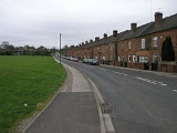
Treeton is a village and civil parish
of the Metropolitan Borough of Rotherham
in South Yorkshire
, England
. It is located about 6 kilometres (3.7 mi) south of the town of Rotherham
and 8 kilometres (5 mi) east of Sheffield City Centre
.
and Neolithic
settlement in this area. For example, in 1954 a Neolithic polished stone axe was found at Gregory Hill Field, and in 1957 Mesolithic flint cores were found in Treeton Wood. There was a Roman fort at Templeborough
, about 4.5 kilometres (2.8 mi) north west of Treeton, and remnants of the Roman road
called Icknield Street
(sometimes Ryknild or Riknild Street) have been found in nearby Brinsworth
.
The name Treeton is Old English in origin and may mean 'tree farmstead' or ‘farmstead built with posts’. The earliest know written record of Treeton is the Domesday book
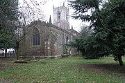
of 1086, in which it is referred to as Trectone or Tretone. The Domesday Book also mentions that the village had two mills and a church. The present parish church
the Church of St Helen
was originally built in the 12th century, but may have included parts of an earlier church. The church was expanded in the 14th century and extensively restored
in the 19th century.
The North Midland Railway
built a railway through the village in 1840, this later became the Midland Railway
. There was a station at Treeton
until 1951. A colliery was built at Treeton starting in 1875, and 400 houses were built between 1881 and 1905 to house miners families. Treeton Colliery closed in 1990 and the site has since been redeveloped for homes.
. This ward is part of the Rother Valley
parliamentary constituency, and is represented in the House of Commons by MP
Kevin Barron
of the Labour Party who has held the seat since 1983.
, about 6 kilometres (3.7 mi) south of the town of Rotherham
and 8 kilometres (5 mi) east of Sheffield City Centre
. The village sits on the slopes of the Rother Valley, ranging from about 40 metres (131.2 ft) to 80 metres (262.5 ft) above mean sea level. The lower section of the village is susceptible to flooding and had to be evacuated during the floods of June 2007 because of fears that cracks in the dam at Ulley reservoir
could lead to widespread flooding in the valley.
the population of Treeton civil parish was 2,514 people. The ethnic mix was 99.4% white (White British
, White Irish, or White Other
), 0.3% Asian
, and 0.3% mixed race.
Below is a table outlining population change of the parish in 50 year increments since 1801. Note that the figures for 1801 and 1851 are taken from the ancient parish of Treeton, which included the neighbouring villages of Ulley
and Brampton-en-le-Morthen, an area about twice the size of the current civil parish.
 The Church of St. Helen is a Grade I listed building, and the village stocks outside the church are Grade II listed. Other Grade II listed buildings in the village include The Georgian House, formerly the church rectory, and 18th century farm buildings on Station Road and at Spa House Farm.
Catcliffe Flash, to the west of the village, is a local nature reserve that is made up of a lake and marshland formed as the elevation of the land beside the River Rother dropped due to coal mining subsidence
. To the south east of the village are three areas of ancient woodland, Treeton Wood, Hail Mary Hill Wood, and Falconer Wood, which are managed as part of the South Yorkshire Forest
.
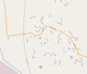 The main road transport route through Treeton is the B6067
. Treeton is situated close to the Sheffield Parkway
and junction 33 of the M1 motorway
. Bus services provided by First South Yorkshire
, Powells Bus Co., and TM Travel link the village with Rotherham Town Centre, Sheffield City Centre, and the Meadowhall Centre, as well as the surrounding villages. The closest mainline railway stations are at Sheffield, Rotherham, and Meadowhall. The former route of the North Midland Railway
runs through the village, and Treeton used to be served by a passenger station on this line, however the station closed in 1951 and the rail line in now freight only.
Civil parish
In England, a civil parish is a territorial designation and, where they are found, the lowest tier of local government below districts and counties...
of the Metropolitan Borough of Rotherham
Metropolitan Borough of Rotherham
The Metropolitan Borough of Rotherham is a metropolitan borough of South Yorkshire, England. It is named for its largest town, Rotherham, but also spans the outlying towns of Maltby, Rawmarsh, Swinton, Wath-upon-Dearne, as well as a suburban and rural element composed of hills, escarpments and...
in South Yorkshire
South Yorkshire
South Yorkshire is a metropolitan county in the Yorkshire and the Humber region of England. It has a population of 1.29 million. It consists of four metropolitan boroughs: Barnsley, Doncaster, Rotherham, and City of Sheffield...
, England
England
England is a country that is part of the United Kingdom. It shares land borders with Scotland to the north and Wales to the west; the Irish Sea is to the north west, the Celtic Sea to the south west, with the North Sea to the east and the English Channel to the south separating it from continental...
. It is located about 6 kilometres (3.7 mi) south of the town of Rotherham
Rotherham
Rotherham is a town in South Yorkshire, England. It lies on the River Don, at its confluence with the River Rother, between Sheffield and Doncaster. Rotherham, at from Sheffield City Centre, is surrounded by several smaller settlements, which together form the wider Metropolitan Borough of...
and 8 kilometres (5 mi) east of Sheffield City Centre
Sheffield City Centre
Sheffield City Centre—often just referred to as town—is a district of the City of Sheffield, and part of the Sheffield Central ward. It includes the area that is within a radius of roughly of Sheffield Cathedral, and is encircled by the Inner Ring Road—a circular route started in the late 1960s...
.
History
There is evidence of MesolithicMesolithic
The Mesolithic is an archaeological concept used to refer to certain groups of archaeological cultures defined as falling between the Paleolithic and the Neolithic....
and Neolithic
Neolithic
The Neolithic Age, Era, or Period, or New Stone Age, was a period in the development of human technology, beginning about 9500 BC in some parts of the Middle East, and later in other parts of the world. It is traditionally considered as the last part of the Stone Age...
settlement in this area. For example, in 1954 a Neolithic polished stone axe was found at Gregory Hill Field, and in 1957 Mesolithic flint cores were found in Treeton Wood. There was a Roman fort at Templeborough
Templeborough
Templeborough is a suburb of Rotherham, South Yorkshire, England. The area takes its name from the remains of the Roman fort found there which were mistakenly believed to be that of a Roman Temple.-Roman fort:...
, about 4.5 kilometres (2.8 mi) north west of Treeton, and remnants of the Roman road
Roman roads in Britain
Roman roads, together with Roman aqueducts and the vast standing Roman army , constituted the three most impressive features of the Roman Empire. In Britain, as in other provinces, the Romans constructed a comprehensive network of paved trunk roads Roman roads, together with Roman aqueducts and the...
called Icknield Street
Icknield Street
Icknield Street or Ryknild Street is a Roman road in Britain that runs from the Fosse Way at Bourton on the Water in Gloucestershire to Templeborough in South Yorkshire...
(sometimes Ryknild or Riknild Street) have been found in nearby Brinsworth
Brinsworth
Brinsworth is a village and civil parish in the Metropolitan Borough of Rotherham, in South Yorkshire, England. It is situated close to the River Rother between Rotherham and Sheffield . At the time of the 2001 census it had a population of 8,950.-History:Brinsworth is located about mile south...
.
The name Treeton is Old English in origin and may mean 'tree farmstead' or ‘farmstead built with posts’. The earliest know written record of Treeton is the Domesday book
Domesday Book
Domesday Book , now held at The National Archives, Kew, Richmond upon Thames in South West London, is the record of the great survey of much of England and parts of Wales completed in 1086...
of 1086, in which it is referred to as Trectone or Tretone. The Domesday Book also mentions that the village had two mills and a church. The present parish church
Parish church
A parish church , in Christianity, is the church which acts as the religious centre of a parish, the basic administrative unit of episcopal churches....
the Church of St Helen
Church of St Helen, Treeton
The Church of St Helen is the parish church in the village of Treeton in South Yorkshire, England. It is a Church of England church in the Diocese of Sheffield...
was originally built in the 12th century, but may have included parts of an earlier church. The church was expanded in the 14th century and extensively restored
Victorian restoration
Victorian restoration is the term commonly used to refer to the widespread and extensive refurbishment and rebuilding of Church of England churches and cathedrals that took place in England and Wales during the 19th-century reign of Queen Victoria...
in the 19th century.
The North Midland Railway
North Midland Railway
The North Midland Railway was a British railway company, which opened its line from Derby to Rotherham and Leeds in 1840.At Derby it connected with the Birmingham and Derby Junction Railway and the Midland Counties Railway at what became known as the Tri Junct Station...
built a railway through the village in 1840, this later became the Midland Railway
Midland Railway
The Midland Railway was a railway company in the United Kingdom from 1844 to 1922, when it became part of the London, Midland and Scottish Railway....
. There was a station at Treeton
Treeton railway station
Treeton railway station was a railway station situated on the North Midland Railway's line between Rotherham Masborough and Chesterfield. It was situated in the centre of the coal mining village of Treeton, in the Rother Valley near Rotherham in South Yorkshire, England.The original Treeton railway...
until 1951. A colliery was built at Treeton starting in 1875, and 400 houses were built between 1881 and 1905 to house miners families. Treeton Colliery closed in 1990 and the site has since been redeveloped for homes.
Governance
Treeton is a civil parish and local issues are governed by a Parish Council, one of 29 such councils in the Metropolitan Borough of Rotherham. It is in the Rother Vale Ward of the Borough, which is represented on the Borough Council by Georgina Boyes, Gerald Nightingale, and John Swift, all members of the Labour PartyLabour Party (UK)
The Labour Party is a centre-left democratic socialist party in the United Kingdom. It surpassed the Liberal Party in general elections during the early 1920s, forming minority governments under Ramsay MacDonald in 1924 and 1929-1931. The party was in a wartime coalition from 1940 to 1945, after...
. This ward is part of the Rother Valley
Rother Valley (UK Parliament constituency)
- Elections in the 2000s :- Elections in the 1990s :- Elections in the 1980s :- Elections in the 1970s :- Elections in the 1960s :...
parliamentary constituency, and is represented in the House of Commons by MP
Member of Parliament
A Member of Parliament is a representative of the voters to a :parliament. In many countries with bicameral parliaments, the term applies specifically to members of the lower house, as upper houses often have a different title, such as senate, and thus also have different titles for its members,...
Kevin Barron
Kevin Barron
Kevin John Barron is a British Labour Party politician who has been the Member of Parliament for Rother Valley since 1983.-Early life:...
of the Labour Party who has held the seat since 1983.
Geography
Treeton is located on the east side of the River RotherRiver Rother, South Yorkshire
The River Rother is a river in the northern midlands of England, after which the town of Rotherham and the Rother Valley parliamentary constituency are named. It rises near Clay Cross in Derbyshire, and flows through the centre of Chesterfield, where it feeds the Chesterfield Canal...
, about 6 kilometres (3.7 mi) south of the town of Rotherham
Rotherham
Rotherham is a town in South Yorkshire, England. It lies on the River Don, at its confluence with the River Rother, between Sheffield and Doncaster. Rotherham, at from Sheffield City Centre, is surrounded by several smaller settlements, which together form the wider Metropolitan Borough of...
and 8 kilometres (5 mi) east of Sheffield City Centre
Sheffield City Centre
Sheffield City Centre—often just referred to as town—is a district of the City of Sheffield, and part of the Sheffield Central ward. It includes the area that is within a radius of roughly of Sheffield Cathedral, and is encircled by the Inner Ring Road—a circular route started in the late 1960s...
. The village sits on the slopes of the Rother Valley, ranging from about 40 metres (131.2 ft) to 80 metres (262.5 ft) above mean sea level. The lower section of the village is susceptible to flooding and had to be evacuated during the floods of June 2007 because of fears that cracks in the dam at Ulley reservoir
Ulley Reservoir
Ulley Reservoir is a reservoir located a few hundred metres to the west and downhill of the village of Ulley, south of Rotherham, South Yorkshire, England...
could lead to widespread flooding in the valley.
Demography
At the time of the United Kingdom 2001 CensusUnited Kingdom Census 2001
A nationwide census, known as Census 2001, was conducted in the United Kingdom on Sunday, 29 April 2001. This was the 20th UK Census and recorded a resident population of 58,789,194....
the population of Treeton civil parish was 2,514 people. The ethnic mix was 99.4% white (White British
White British
White British was an ethnicity classification used in the 2001 United Kingdom Census. As a result of the census, 50,366,497 people in the United Kingdom were classified as White British. In Scotland the classification was broken down into two different categories: White Scottish and Other White...
, White Irish, or White Other
White Other (United Kingdom Census)
The term Other White is used in the UK census to describe people who self-identify as white persons who are not British nor Irish. The category does not comprise a single ethnic group but is instead a method of identification for white people who are not represented by other white census categories...
), 0.3% Asian
British Asian
British Asian is a term used to describe British citizens who descended from mainly South Asia, also known as South Asians in the United Kingdom...
, and 0.3% mixed race.
Below is a table outlining population change of the parish in 50 year increments since 1801. Note that the figures for 1801 and 1851 are taken from the ancient parish of Treeton, which included the neighbouring villages of Ulley
Ulley
Ulley is a village and civil parish of the Metropolitan Borough of Rotherham in South Yorkshire, England. It is located about south of the town of Rotherham and east of Sheffield City Centre.-History:...
and Brampton-en-le-Morthen, an area about twice the size of the current civil parish.
| Year | 1801 | 1851 | 1901 | 1951 | 2001 | ||||||||
|---|---|---|---|---|---|---|---|---|---|---|---|---|---|
| Population | 628 | 663 | 1,969 | 2,040 | 2,514 | ||||||||
| Source: A Vision of Britain through Time | |||||||||||||
Landmarks
Catcliffe Flash, to the west of the village, is a local nature reserve that is made up of a lake and marshland formed as the elevation of the land beside the River Rother dropped due to coal mining subsidence
Subsidence
Subsidence is the motion of a surface as it shifts downward relative to a datum such as sea-level. The opposite of subsidence is uplift, which results in an increase in elevation...
. To the south east of the village are three areas of ancient woodland, Treeton Wood, Hail Mary Hill Wood, and Falconer Wood, which are managed as part of the South Yorkshire Forest
South Yorkshire Forest
The South Yorkshire Forest is a partnership initiative of the twelve Community Forests in England. The project was started in 1991. It is a project that aims to create attractive landscapes in the South Yorkshire area through improvement and regeneration of woodlands, wetlands, farmland, meadows,...
.
Transport
Great Britain road numbering scheme
The Great Britain road numbering scheme is a numbering scheme used to classify and identify all roads in Great Britain. Each road is given a single letter, which represents the road's category, and a subsequent number, with a length of between 1 and 4 digits. Originally introduced to arrange...
. Treeton is situated close to the Sheffield Parkway
Sheffield Parkway
The Sheffield Parkway is a major dual carriageway which runs between the City of Sheffield and junction 33 of the M1 in South Yorkshire, England. The 5.5 mile road was opened in 1974, and runs to the east of the City, connecting Park Square in the City centre with the inner ring road, outer ring...
and junction 33 of the M1 motorway
M1 motorway
The M1 is a north–south motorway in England primarily connecting London to Leeds, where it joins the A1 near Aberford. While the M1 is considered to be the first inter-urban motorway to be completed in the United Kingdom, the first road to be built to motorway standard in the country was the...
. Bus services provided by First South Yorkshire
First South Yorkshire
First South Yorkshire is the largest bus operator in South Yorkshire, England. As a division of FirstGroup the company's legal name was, for a time, Mainline which operated it between 1993 and 1998, following the sale South Yorkshire Transport to its employees.-History:SYT was eventually sold to...
, Powells Bus Co., and TM Travel link the village with Rotherham Town Centre, Sheffield City Centre, and the Meadowhall Centre, as well as the surrounding villages. The closest mainline railway stations are at Sheffield, Rotherham, and Meadowhall. The former route of the North Midland Railway
North Midland Railway
The North Midland Railway was a British railway company, which opened its line from Derby to Rotherham and Leeds in 1840.At Derby it connected with the Birmingham and Derby Junction Railway and the Midland Counties Railway at what became known as the Tri Junct Station...
runs through the village, and Treeton used to be served by a passenger station on this line, however the station closed in 1951 and the rail line in now freight only.