Transverse Mercator: Redfearn series
Encyclopedia
The article Transverse Mercator projection
restricts itself to general features of the projection. This article describes in detail one of the (two) implementations developed by Louis Krüger in 1912; that expressed as a power series in the longitude difference from the central meridian. These series were recalculated by Lee in 1946, by Redfearn in 1948, and by Thomas in 1952. They are often referred to as the Redfearn series, or the Thomas series. This implementation is of great importance since it is widely used in the U.S. State Plane Coordinate System, in national (Britain, Ireland and many others) and also international mapping systems, including the Universal Transverse Mercator coordinate system
(UTM). They are also incorporated into the Geotrans coordinate converter made available by the United States National Geospatial-Intelligence Agency. When paired with a suitable geodetic datum, the series deliver high accuracy in zones less than a few degrees in east-west extent.
. Although the projection formulae depend only on the shape parameters of the reference ellipsoid the full set of datum parameters is necessary to link the projection coordinates to true positions in three dimensional space. The datums and reference ellipsoids associated with particular implementations of the Redfearn formulae are listed below. A comprehensive list of important ellipsoids is given in the article on the Figure of the Earth.
In specifying ellipsoids it is normal to give the semi-major axis
(equatorial axis), , along with either the inverse flattening
, , or the semi-minor axis
(polar axis), , or sometimes both. The series presented below use the eccentricity ,
  , in preference to the flattening,
  . In addition they use the parameters
  , called the third flattening, and
  , the second eccentricity
. There are only two independent independent shape parameters and there are many relations between them: in particular
Transverse Mercator projection
The transverse Mercator map projection is an adaptation of the standard Mercator projection. The transverse version is widely used in national and international mapping systems around the world, including the UTM...
restricts itself to general features of the projection. This article describes in detail one of the (two) implementations developed by Louis Krüger in 1912; that expressed as a power series in the longitude difference from the central meridian. These series were recalculated by Lee in 1946, by Redfearn in 1948, and by Thomas in 1952. They are often referred to as the Redfearn series, or the Thomas series. This implementation is of great importance since it is widely used in the U.S. State Plane Coordinate System, in national (Britain, Ireland and many others) and also international mapping systems, including the Universal Transverse Mercator coordinate system
Universal Transverse Mercator coordinate system
The Universal Transverse Mercator geographic coordinate system uses a 2-dimensional Cartesian coordinate system to give locations on the surface of the Earth. It is a horizontal position representation, i.e...
(UTM). They are also incorporated into the Geotrans coordinate converter made available by the United States National Geospatial-Intelligence Agency. When paired with a suitable geodetic datum, the series deliver high accuracy in zones less than a few degrees in east-west extent.
Preliminaries I: datum and ellipsoid parameters
The series must be used with a geodetic datum which specifies the position, orientation and shape of a Reference ellipsoidFigure of the Earth
The expression figure of the Earth has various meanings in geodesy according to the way it is used and the precision with which the Earth's size and shape is to be defined. The actual topographic surface is most apparent with its variety of land forms and water areas. This is, in fact, the surface...
. Although the projection formulae depend only on the shape parameters of the reference ellipsoid the full set of datum parameters is necessary to link the projection coordinates to true positions in three dimensional space. The datums and reference ellipsoids associated with particular implementations of the Redfearn formulae are listed below. A comprehensive list of important ellipsoids is given in the article on the Figure of the Earth.
In specifying ellipsoids it is normal to give the semi-major axis
Semi-major axis
The major axis of an ellipse is its longest diameter, a line that runs through the centre and both foci, its ends being at the widest points of the shape...
(equatorial axis),
, along with either the inverse flatteningFlattening
The flattening, ellipticity, or oblateness of an oblate spheroid is a measure of the "squashing" of the spheroid's pole, towards its equator...
,
, or the semi-minor axisSemi-minor axis
In geometry, the semi-minor axis is a line segment associated with most conic sections . One end of the segment is the center of the conic section, and it is at right angles with the semi-major axis...
(polar axis),
, or sometimes both. The series presented below use the eccentricity , , in preference to the flattening, . In addition they use the parameters , called the third flattening, and , the second eccentricityEccentricity (mathematics)
In mathematics, the eccentricity, denoted e or \varepsilon, is a parameter associated with every conic section. It can be thought of as a measure of how much the conic section deviates from being circular.In particular,...
. There are only two independent independent shape parameters and there are many relations between them: in particular
-

The projection formulae also involve , the radius of curvature of the meridian (at latitude
  ), and
  , the radius of curvature in the prime verticalPrime verticalIn astronomy and astrology, the prime vertical is the vertical circle passing east and west through the zenith, and intersecting the horizon in its east and west points....
.
(The prime vertical is the vertical plane orthogonal to the meridian plane at a point on the ellipsoid). The radii of curvature are defined as follows: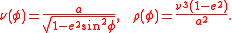
In addition the functions and
and  are defined as:
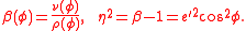
For compactness it is normal to introduce the following abbreviations:-

Meridian distance
The article on Meridian arcMeridian arcIn geodesy, a meridian arc measurement is a highly accurate determination of the distance between two points with the same longitude. Two or more such determinations at different locations then specify the shape of the reference ellipsoid which best approximates the shape of the geoid. This...
describes several methods of computing , the meridian distance from the equator to a point at latitude
  : the expressions given below are those used in the actual implementation of the Transverse Mercator projection by the OSGB. The truncation error is less than 0.1mm so the series is certainly accurate to within 1mm, the design tolerance of the OSGB implementation.
-

where the coefficients are given to order (order
  ) by
) by
-
The meridian distance from equator to pole is
The form of the series specified for UTM is a variant of the above exhibiting higher order terms with a truncation error of 0.03mm.
Inverse meridian distance
Neither the OSGB nor the UTM implementations define an inverse series for the meridian distance; instead they use an iterative scheme. For a given meridian distance first set
  and then iterate using
-

until mm.
mm.
The inversion can be effected by a series, presented here for later reference. For a given meridian distance, , define the rectifying latitudeLatitudeIn geography, the latitude of a location on the Earth is the angular distance of that location south or north of the Equator. The latitude is an angle, and is usually measured in degrees . The equator has a latitude of 0°, the North pole has a latitude of 90° north , and the South pole has a...
by-

The geodetic latitude corresponding to is (Snyder page 17):
-

where, to ,
,
-

An outline of the method
The normal aspect of the Mercator projection of a sphere of radius is described by the equations
where , the isometric latitude, is given by
-

On the ellipsoid the isometric latitude becomes-

By construction, the projection from the geodetic coordinates ( ,
, ) to the coordinates (
 ,
, ) is conformal. If the coordinates (
 ,
, ) are used to define a point
  in the complex plane, then any analytic function
  will define another conformal projection. Kruger's method involves seeking the specific
  which generates a uniform scale along the central meridian,
  . He achieved this by investigating a Taylor series approximation with the projection coordinates given by:
-

where the real part of must be proportional to the meridian distance function
  . The (complex) coefficients
  depend on derivatives of
  which can be reduced to derivatives of
  with respect to
  , (not
  ). The derivatives are straightforward to evaluate in principle but the expressions become very involved at high orders because of the complicated relation between
  and
and  . Separation of real and imaginary parts gives the series for
  and
and  and further derivatives give the scale and convergence factors.
The series in detail
This section presents the eighth order series as published by Redfearn (but with and
and  interchanged and the longitude difference from the central meridian denoted by
  instead of
  ). Equivalent eighth order series, with different notations, can be found in Snyder (pages 60–64) and at many web sites such as that for the Ordnance Survey of Great Britain.
The direct series are developed in terms of the longitude difference from the central meridian, expressed in radians: the inverse series are developed in terms of the ratio . The projection is normally restricted to narrow zones (in longitude) so that both of the expansion parameters are typically less than about 0.1, guaranteeing rapid convergence. For example in each UTMUniversal Transverse Mercator coordinate systemThe Universal Transverse Mercator geographic coordinate system uses a 2-dimensional Cartesian coordinate system to give locations on the surface of the Earth. It is a horizontal position representation, i.e...
zone these expansion parameters are less than 0.053 and for the British national grid (NGGBBritish national grid reference systemThe Ordnance Survey National Grid reference system is a system of geographic grid references used in Great Britain, different from using latitude and longitude....
) they are less than 0.09. All of the direct series giving ,
,  , scale
  , convergence
  are functions of both latitude and longitude and the parameters of the ellipsoid: all inverse series giving
  ,
,  ,
,  ,
,  are functions of both
  and
and  and the parameters of the ellipsoid.
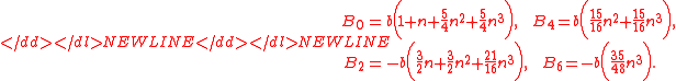
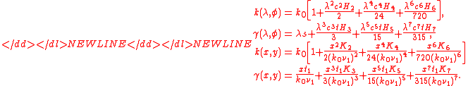
Direct series
In the following series is the difference of the longitude of an arbitrary point and the longitude of the chosen central meridian:
  is in radians and is positive east of the central meridian. The W coefficients are functions of
  listed below. The series for
  reduces to the scaled meridian distance when
  .
.
-

Inverse series
The inverse series involve a further construct: the footpoint latitude. Given a point on the projection the footpoint is defined as the point on the central meridian with coordinates
  . Since the scale on the central meridian is
  the meridian distance from the equator to the footpoint is equal to
  . The corresponding footpoint latitude,
  , is calculated by iteration or the inverse meridian distance series as described above.
-

Denoting functions evaluated at by a subscript '1', the inverse series are:
-
Point scale and convergence
The point scale is independent of direction for a conformal transformation. It may be calculated in terms of geographic or projection coordinates. Note that the series for
  reduce to
  when either
  or
or  . The convergence
  may also be calculated (in radians) in terms of geographic or projection coordinates:
-
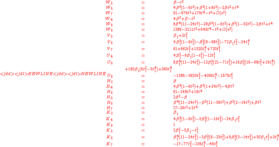
The coefficients for all series
-
Accuracy of the series
The exact solution of Lee-Thompson, implemented by Karney (2011), is of great value in assessing the accuracy of the truncated Redfearn series. It confirms that the truncation error of the (eighth order) Redfearn series is less than 1 mm out to a longitude difference of 3 degrees, corresponding to a distance of 334 km from the central meridian at the equator but a mere 35 km at the northern limit of an UTM zone.
The Redfearn series become much worse as the zone widens. Karney discusses Greenland as an instructive example. The long thin landmass is centred on 42W and, at its broadest point, is no more than 750 km from that meridian whilst the span in longitude reaches almost 50 degrees. The Redfearn series attain a maximum error of 1 kilometre.
Coordinates, grids, eastings and northings
The projection coordinates as defined above are Cartesian coordinates such that the central meridian corresponds to and the equator corresponds
  . Both x and y are defined for all values of
  and
and  (although
  tends to (±) infinity as
  tends to ±90° or ±π/2 radians). The projection does not define a grid: the grid is an independent construct which could be defined arbitrarily. In practice the national implementations, and UTM, use grids aligned with the Cartesian axes of the projection but they are of finite extent, with origins which need not coincide with the origin of the projection coordinates where the central meridian intersects the equator. (Note that in the overlap regions of the UTM zones at neighbouring grids are inclined with respect to each other).
The true grid origin is always taken on the central meridian so that grid coordinates will be negative west of the central meridian. To avoid such negative grid coordinates standard practice defines a false origin to the west (and possibly north or south) of the grid origin: the coordinates relative to the false origin define Eastings and Northings which will always be positive. The false Easting, , is the distance of the true grid origin east of the false origin. The false Northing,
  , is the distance of the true grid origin north of the false origin. If the true origin of the grid is at latitude
  on the central meridian and the scale factor the central meridian is
  then these definitions give Eastings and Northings by:
-
-

The inverse series are calculated from the Redfearn series with replaced by
  and the footpoint latitude calculated by inversion of
-

The terms Eastings and Northings are misnomers. Grid lines of the transverse projection, other than the axes and
and  do not run north-south or east-west as defined by parallels and meridians. This is evident from the global projections in Transverse Mercator projectionTransverse Mercator projectionThe transverse Mercator map projection is an adaptation of the standard Mercator projection. The transverse version is widely used in national and international mapping systems around the world, including the UTM...
. Near the central meridian the differences are small but measurable. The difference between the north-south grid lines and the true meridians is the angle of convergence.
Implementations
The implementations give below are examples of the use of the Redfearn series. The defining documents in various countries differ slightly in notation and, more importantly, in the neglect of some of the small terms. The analysis of small terms depends on the on the latitude and longitude ranges in the various grids. There are also slight differences in the formulae utilised for meridian distance: one extra term is sometimes added to the formula specified above but such a term is less than 0.1mm.
OSGB
The implementation of the transverse Mercator projection in Great Britain is fully described in the document A guide to coordinate systems in Great Britain, Appendices A.1, A.2 and C.-
- datum: OSGB36
- ellipsoid: Airy 1830
- major axis: 6 377 563.396
- minor axis: 6 356 256.909
- central meridian longitude: 2°W
- central meridian scale factor : 0.9996012717
- projection origin: 2°W and 0°N
- true grid origin: 2°W and 49°N
- false easting of true grid origin, E0 (metres): 400,000
- false northing of true grid origin, N0 (metres): -100,000
- E = E0 + x = 400000 + x
- N = N0 + y -k0*m(49°)= y - 5527063
The extent of the grid is 300 km to the east and 400 km to the west of the central meridian and 1300 km north from the false origin, (OSGB Section 7.1), but with the exclusion of parts of Northern Ireland, Eire and France. A grid reference is denoted by the pair (E,N) where E ranges from slightly over zero to 800000m and N ranges from zero to 1300000m.To reduce the number of figures needed to give a grid reference, the grid is divided into 100 km squares, which each have a two-letter code. National Grid positions can be given with this code followed by an easting and a northing both in the range 0 and 99999m.
The projection formulae differ slightly from the Redfearn formulae presented here. They have been simplified by neglect of most terms of seventh and eighth order in or
or  : the only exception is seventh order term in the series for
  in terms of
  . This simplification is based on the examination of the Redfearn terms over the actual extent of the grid. The only other differences are (a) the absorption of the central scale factor into the radii of curvature and meridian distance, (b) the replacement of the parameter
  by the parameter
  (defined above).
The OSGB manual includes a discussion of the Helmert transformations which are required to link geodetic coordinates on Airy 1830 ellipsoid and on WGS84.
UTM
The article on the Universal Transverse Mercator projectionUniversal Transverse Mercator coordinate systemThe Universal Transverse Mercator geographic coordinate system uses a 2-dimensional Cartesian coordinate system to give locations on the surface of the Earth. It is a horizontal position representation, i.e...
gives a general survey, but the full specification is defined in U.S. Defence Mapping Agency Technical Manuals TM8358.1 and TM8358.2. This section provides details for zone 30 as another example of the Redfearn formulae (usually termed Thomas formulae in the United States.)-
- ellipsoid: International 1924 (a.k.a. Hayford 1909)
- major axis: 6 378 388.000
- minor axis: 6 356 911.946
- central meridian longitude: 3°W
- projection origin: 3°W and 0°N
- central meridian scale factor: 0.9996
- true grid origin: 3°W and 0°N
- false easting of true grid origin, E0: 500,000
- E = E0 + x = 500000 + x
- northern hemisphere false northing of true grid origin N0: 0
- northern hemisphere: N = N0 + y = y
- southern hemisphere false northing of true grid origin N0: 10,000,000
- southern hemisphere: N = N0 + y = 10,000,000 + y
The series adopted for the meridian distance incorporates terms of fifth order in but the manual states that these are less than 0.03 mm (TM8358.2 Chapter 2). The projection formulae use,
  , the second eccentrity (defined above) instead of
  . The grid reference schemes are defined in the article Universal Transverse Mercator coordinate systemUniversal Transverse Mercator coordinate systemThe Universal Transverse Mercator geographic coordinate system uses a 2-dimensional Cartesian coordinate system to give locations on the surface of the Earth. It is a horizontal position representation, i.e...
. The accuracy claimed for the UTM projections is 10 cm in grid coordinates and 0.001 arc seconds for geodetic coordinates.
Ireland
The transverse Mercator projection in Eire and Northern Ireland (an international implementation spanning one country and part of another) is currently implemented in two ways:
Irish grid reference system-
- datum: Ireland 1965
- ellipsoid: Airy 1830 modified
- major axis: 6 377 340.189
- minor axis: 6 356 034.447
- central meridian scale factor: 1.000035
- true origin: 8°W and 53.5°N
- false easting of true grid origin, E0: 200,000
- false northing of true grid origin, N0: 250,000
The Irish grid uses the OSGB projection formulae.
Irish Transverse MercatorIrish Transverse MercatorIrish Transverse Mercator , is the geographic coordinate system for Ireland. It was implemented jointly by the Ordnance Survey Ireland and the Ordnance Survey of Northern Ireland in 2001...
-
- datum: Ireland 1965
- ellipsoid: GRS80
- major axis: ?
- minor axis: ?
- central meridian scale factor: 0.999820
- true origin: 8°W and 53.5°N
- false easting of true grid origin, E0: 600,000
- false northing of true grid origin, N0: 750,000
This is an interesting example of the transition between use of a traditional ellipsoid and a modern global ellipsoid. The adoption of radically different false origins helps to prevent confusion between the two systems.
See also
- Mercator projectionMercator projectionThe Mercator projection is a cylindrical map projection presented by the Belgian geographer and cartographer Gerardus Mercator, in 1569. It became the standard map projection for nautical purposes because of its ability to represent lines of constant course, known as rhumb lines or loxodromes, as...
- Map projectionMap projectionA map projection is any method of representing the surface of a sphere or other three-dimensional body on a plane. Map projections are necessary for creating maps. All map projections distort the surface in some fashion...
- Scale (map)Scale (map)The scale of a map is defined as the ratio of a distance on the map to the corresponding distance on the ground.If the region of the map is small enough for the curvature of the Earth to be neglected, then the scale may be taken as a constant ratio over the whole map....
- Universal Transverse Mercator coordinate systemUniversal Transverse Mercator coordinate systemThe Universal Transverse Mercator geographic coordinate system uses a 2-dimensional Cartesian coordinate system to give locations on the surface of the Earth. It is a horizontal position representation, i.e...
-
-
-
-
-
-
-
-
-
-
-
-
-
-
-
-
-
-
-