
Transport in Himachal Pradesh
Encyclopedia
The development of tribal areas in Himachal Pradesh
is one of the major steps taken by the state government for its economic development. The border districts of Kinnaur, Lahaul, Spiti
and the Pangi and Brahmour tehsils of Chamba
districts are the major tribal areas of the state. They are located near the borders of Tibet
. Due to poor accessibility, life in these areas had grown in isolation.
. Lahaul is only in contact due to high passes like Rohtang (4,000 m, 13,050 ft), Kunzum (4,600 m, 14,913 ft) and Baralarcha (4,300 m, 14,000 ft).
Spiti
is a cold desert and is a very underdeveloped area.
The building up of an efficient transport system was the top most priority in the first Five year plan. The state has two airports at Bhintar in Kullu
district, and at Jubbarhatti near Shimla
. It was only by January 1991 that Himachal was linked up with the broad gauge system by extending the Delhi-Nangal rail line. Although railways and airways in Himachal serve very limited transport needs of the people, the road network of the state makes it unique.
 Eight national highways (NH) pass through the state with a total length of 1235 km. NH 1A touches Shahpur. NH 20 passes through Pathankot, Chakki, Nurpur, Palampur
and Mandi. NH 21 connects Chandigarh with Manali through Mandi. NH 22 connects Ambala with Kaurik through Kalka
, Simla
and Wangtoo. NH 70 passes through Mubarakpur, Amb, Nadaun and Hamirpur. NH 21A begins at Pinjore in Haryana, passes through Nalagarh and reaches Swarghat, where it connects with NH 21. NH 88 connects Shimla with Kangra through Hamirpur and Nadaun. NH 72 begins at Ambala and passes through Amb and Paunta Sahib in Himachal before terminating at Haridwar in Uttarakhand
.
In addition to the National Highways, the state also has a large mesh of highways and village roads. Most tourist spots in Himachal Pradesh such as Shimla
, Manali, Dharamsala
etc. are well connected by roads. Some of the roads in Himachal are seasonal and get closed during winters and monsoons due to heavy snowfall, landslides and washouts. The Manali-Leh road
, for example, remains closed for most part of the winters. The World Bank
has approved a loan of $ 220 million in 2007 to improve priority segments of the state road network.
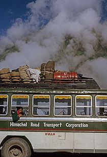
The government-owned Himachal Road Transport Corporation runs a network of buses across the state and Himachal Pradesh being a major tourist destination, there is no dearth of private buses and taxis. In spite of state being hilly, Hamirpur District
has got highest road density in the country.
See also
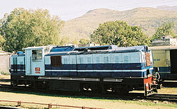 Himachal has two narrow-gauge rail tracks. The Kalka-Shimla Railway
track has a length of 96 kilometers. It passes through 102 tunnels and crosses 864 bridges. The track has been in existence for over a century now. Panoramic Kalka-Shimla Railway known to be an engineering marvel of British India. The level of difficulty in laying of tracks could be judged by a journey in the route.
The Pathankot-Jogindernagar track has a length of about 113 kilometers.
Both these tracks are commercially unviable but are operated because of their heritage value.
A broad gauge line exists which connects Nangal
Dam in Punjab
to Una
. Currently this line is being extended till Talwara (Punjab) with track operational till Churu takarla .
Una is connected to New Delhi
by Jan Shatabdi express and Himachal Express .
near Shimla, Gaggal Airport
near Kangra and Bhuntar Airport
near Kullu. The flights operate only seasonally due to extreme weather conditions, especially during winters. All these airports have runways shorter than 4000 ft and therefore allow the operation of only the smaller aircraft such as the 18-seater Dornier & 42 seater ATR, which is the most common aircraft operating on these runways.
Himachal Pradesh
Himachal Pradesh is a state in Northern India. It is spread over , and is bordered by the Indian states of Jammu and Kashmir on the north, Punjab on the west and south-west, Haryana and Uttar Pradesh on the south, Uttarakhand on the south-east and by the Tibet Autonomous Region on the east...
is one of the major steps taken by the state government for its economic development. The border districts of Kinnaur, Lahaul, Spiti
Spiti
-Geographical locations:*Lahaul and Spiti, a district in the state of Himachal Pradesh in India.*Spiti Valley, former heartland of the former Spiti district now combined.*Spiti River, in the Spiti Valley, Himachal Pradesh.*Spitia River-Language:...
and the Pangi and Brahmour tehsils of Chamba
Chamba district
Chamba is the northwestern district of Himachal Pradesh, in India, with its headquarters in Chamba town. The towns of Dalhousie and Khajjhiar are popular hill stations and vacation spots for the people from the plains of northern India....
districts are the major tribal areas of the state. They are located near the borders of Tibet
Tibet
Tibet is a plateau region in Asia, north-east of the Himalayas. It is the traditional homeland of the Tibetan people as well as some other ethnic groups such as Monpas, Qiang, and Lhobas, and is now also inhabited by considerable numbers of Han and Hui people...
. Due to poor accessibility, life in these areas had grown in isolation.
History and development
Kinnaur was opened up in the early 1960s with the completion of the Hindustan-Tibet National highway. Lahaul was opened up in the late 1960s with the construction of roads over Rohtang passRohtang Pass
Rohtang Pass , is a high mountain pass on the eastern Pir Panjal Range of the Himalayas some from Manali...
. Lahaul is only in contact due to high passes like Rohtang (4,000 m, 13,050 ft), Kunzum (4,600 m, 14,913 ft) and Baralarcha (4,300 m, 14,000 ft).
Spiti
Spiti
-Geographical locations:*Lahaul and Spiti, a district in the state of Himachal Pradesh in India.*Spiti Valley, former heartland of the former Spiti district now combined.*Spiti River, in the Spiti Valley, Himachal Pradesh.*Spitia River-Language:...
is a cold desert and is a very underdeveloped area.
The building up of an efficient transport system was the top most priority in the first Five year plan. The state has two airports at Bhintar in Kullu
Kullu
Kullu, once known as Kul-anti-peetha - "the end of the habitable world", is the capital town of the Kullu District, in the state of Himachal Pradesh, India. It is located on the banks of the Beas River in the Kullu Valley about ten kilometres north of the airport at Bhuntar.Kullu is a broad open...
district, and at Jubbarhatti near Shimla
Shimla
Shimla , formerly known as Simla, is the capital city of Himachal Pradesh. In 1864, Shimla was declared the summer capital of the British Raj in India. A popular tourist destination, Shimla is often referred to as the "Queen of Hills," a term coined by the British...
. It was only by January 1991 that Himachal was linked up with the broad gauge system by extending the Delhi-Nangal rail line. Although railways and airways in Himachal serve very limited transport needs of the people, the road network of the state makes it unique.
Geography
The geography of Himachal presents considerable challenge to the development of transport infrastructure. Nevertheless, the state has made significant progress in road connectivity in the last few decades. Himachal at present has the highest road density among all the hill states of India. Although Himachal also has three airports and two narrow gauge rail tracks, roads remain the main mode of transport in Himachal.Roads
Palampur
Palampur is a green hill station and a municipal council in the Kangra Valley in the Indian state of Himachal Pradesh, surrounded on all sides by tea gardens and pine forests before they merge with the Dhauladhar ranges. Palampur is the tea capital of northwest India but tea is just one aspect that...
and Mandi. NH 21 connects Chandigarh with Manali through Mandi. NH 22 connects Ambala with Kaurik through Kalka
Kalka
Kalka is a town in the Panchkula district of Haryana, India. The name of the town is derived from the goddess Kali. The town is situated in the foothills of the Himalayas and is a gateway to the neighbouring state of Himachal Pradesh. It is on the National Highway 22 between Chandigarh and Shimla,...
, Simla
Shimla
Shimla , formerly known as Simla, is the capital city of Himachal Pradesh. In 1864, Shimla was declared the summer capital of the British Raj in India. A popular tourist destination, Shimla is often referred to as the "Queen of Hills," a term coined by the British...
and Wangtoo. NH 70 passes through Mubarakpur, Amb, Nadaun and Hamirpur. NH 21A begins at Pinjore in Haryana, passes through Nalagarh and reaches Swarghat, where it connects with NH 21. NH 88 connects Shimla with Kangra through Hamirpur and Nadaun. NH 72 begins at Ambala and passes through Amb and Paunta Sahib in Himachal before terminating at Haridwar in Uttarakhand
Uttarakhand
Uttarakhand , formerly Uttaranchal, is a state in the northern part of India. It is often referred to as the Land of Gods due to the many holy Hindu temples and cities found throughout the state, some of which are among Hinduism's most spiritual and auspicious places of pilgrimage and worship...
.
In addition to the National Highways, the state also has a large mesh of highways and village roads. Most tourist spots in Himachal Pradesh such as Shimla
Shimla
Shimla , formerly known as Simla, is the capital city of Himachal Pradesh. In 1864, Shimla was declared the summer capital of the British Raj in India. A popular tourist destination, Shimla is often referred to as the "Queen of Hills," a term coined by the British...
, Manali, Dharamsala
Dharamsala
Dharamshala or Dharamsala is a city in northern India. It was formerly known as Bhagsu; it is the winter seat of government of the state of Himachal Pradesh and the district headquarters of the Kangra district....
etc. are well connected by roads. Some of the roads in Himachal are seasonal and get closed during winters and monsoons due to heavy snowfall, landslides and washouts. The Manali-Leh road
Leh-Manali Highway
The Leh-Manali Highway is a highway in India connecting Leh and Manali. It is open only between June and mid-September when snow is cleared from the road by the Border Roads Organisation. It connects the Manali valley to Kullu valley, Lahaul and Spiti and Ladakh...
, for example, remains closed for most part of the winters. The World Bank
World Bank
The World Bank is an international financial institution that provides loans to developing countries for capital programmes.The World Bank's official goal is the reduction of poverty...
has approved a loan of $ 220 million in 2007 to improve priority segments of the state road network.
The government-owned Himachal Road Transport Corporation runs a network of buses across the state and Himachal Pradesh being a major tourist destination, there is no dearth of private buses and taxis. In spite of state being hilly, Hamirpur District
Hamirpur District, Himachal Pradesh
Hamirpur district is one of the 12 districts of the state of Himachal Pradesh, India. The headquarters of the district is in the Hamirpur town...
has got highest road density in the country.
See also
- List of RTO districts in Himachal Pradesh
- List of state highways in Himachal Pradesh
- List of Major District Roads in Himachal Pradesh
Railway
Kalka-Shimla Railway
The Kalka–Shimla Railway is a narrow gauge railway in North-West India travelling along a mostly mountainous route from Kalka to Shimla. It is known for breathtaking views of the hills and surrounding villages.- History :...
track has a length of 96 kilometers. It passes through 102 tunnels and crosses 864 bridges. The track has been in existence for over a century now. Panoramic Kalka-Shimla Railway known to be an engineering marvel of British India. The level of difficulty in laying of tracks could be judged by a journey in the route.
The Pathankot-Jogindernagar track has a length of about 113 kilometers.
Both these tracks are commercially unviable but are operated because of their heritage value.
A broad gauge line exists which connects Nangal
Nangal
Nangal is a town 60 km from Rupnagar in the state of Punjab in northwest India. It sits at the foot of the Shiwalik Hills and is surrounded by beautiful hills, the Satluj River and canals. It is an important center for tourists.- Description :...
Dam in Punjab
Punjab (India)
Punjab ) is a state in the northwest of the Republic of India, forming part of the larger Punjab region. The state is bordered by the Indian states of Himachal Pradesh to the east, Haryana to the south and southeast and Rajasthan to the southwest as well as the Pakistani province of Punjab to the...
to Una
Una, Himachal Pradesh
Una is a city and a municipal council in Una district in the Indian state of Himachal Pradesh.-Geography:Una is located at . It has an average elevation of 369 metres .-Demographics:...
. Currently this line is being extended till Talwara (Punjab) with track operational till Churu takarla .
Una is connected to New Delhi
New Delhi
New Delhi is the capital city of India. It serves as the centre of the Government of India and the Government of the National Capital Territory of Delhi. New Delhi is situated within the metropolis of Delhi. It is one of the nine districts of Delhi Union Territory. The total area of the city is...
by Jan Shatabdi express and Himachal Express .
Air
The three airports in Himachal Pradesh are: Shimla AirportShimla Airport
- External links :* at Airports Authority of India web site...
near Shimla, Gaggal Airport
Gaggal Airport
-External links:* at Airports Authority of India web site...
near Kangra and Bhuntar Airport
Bhuntar
Bhuntar is a town and a nagar panchayat in Kullu district in the state of Himachal Pradesh, India.-Demographics: India census, Bhuntar had a population of 5260. Males constitute 55% of the population and females 45%. Bhuntar has an average literacy rate of 80%, higher than the national average of...
near Kullu. The flights operate only seasonally due to extreme weather conditions, especially during winters. All these airports have runways shorter than 4000 ft and therefore allow the operation of only the smaller aircraft such as the 18-seater Dornier & 42 seater ATR, which is the most common aircraft operating on these runways.
External links
- http://www.tribuneindia.com/2003/20031104/himachal.htm#1
- http://www.shimla-travel.com/shimla_railway.shtml
- http://hill-stations-india.com/hill-trains-india/kalka-shimla-railway.html
- http://www.pearcedale.com/c&b/DL.html#indi
- Article in The Tribune
- Article on Kalka Shimla Rail