

Leh-Manali Highway
Encyclopedia

Highway
A highway is any public road. In American English, the term is common and almost always designates major roads. In British English, the term designates any road open to the public. Any interconnected set of highways can be variously referred to as a "highway system", a "highway network", or a...
in India
India
India , officially the Republic of India , is a country in South Asia. It is the seventh-largest country by geographical area, the second-most populous country with over 1.2 billion people, and the most populous democracy in the world...
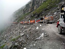
connecting Leh and Manali. It is open only between June and mid-September when snow is cleared from the road by the Border Roads Organisation
Border Roads Organisation
The Border Roads Organisation maintains roads that serve the borders areas of India. It is staffed with a combination of Border Roads Engineering Service officers from the General Reserve Engineer Force and officers from the Corps of Engineers of the Indian Army. The organisation develops and...
. It connects the Manali valley to Kullu
Kullu
Kullu, once known as Kul-anti-peetha - "the end of the habitable world", is the capital town of the Kullu District, in the state of Himachal Pradesh, India. It is located on the banks of the Beas River in the Kullu Valley about ten kilometres north of the airport at Bhuntar.Kullu is a broad open...
valley, Lahaul and Spiti and Ladakh
Ladakh
Ladakh is a region of Jammu and Kashmir, the northernmost state of the Republic of India. It lies between the Kunlun mountain range in the north and the main Great Himalayas to the south, inhabited by people of Indo-Aryan and Tibetan descent...
. It is made part of NH 21, with completion date of 2012.
The highway crosses some of the highest mountain passes in the world, including Rohtang La
Rohtang Pass
Rohtang Pass , is a high mountain pass on the eastern Pir Panjal Range of the Himalayas some from Manali...
3978 m (13,051.2 ft), Baralacha La
Bara-lacha-la
Bara-lacha la also known as Bara-lacha Pass, or Bārā Lācha La, is a high mountain pass in Zanskar range, connecting Lahaul district in Himachal Pradesh to Ladakh in Jammu and Kashmir, situated along the Leh-Manali highway....
4892 m (16,049.9 ft), Lachulung La
Lungalacha La
Lachulung La , or Lāchālūng La or Lungalacha La, is a mountain pass along the Leh-Manali highway. It is located some from Sarchu and from Pang on the Leh-Manali highway....
5059 m (16,597.8 ft) and Taglang La
Tanglang la
Taglang La, elevation , is a high mountain pass in Ladakh, India.It is sometimes incorrectly claimed to be the world’s second highest motorable pass at an altitude of 5,325 m. . See the article on Khardung La for a discussion of the world's highest motorable passes...
5325 m (17,470.5 ft). The latter two passes are less problematic over former due to less snowfall in Ladakh
Ladakh
Ladakh is a region of Jammu and Kashmir, the northernmost state of the Republic of India. It lies between the Kunlun mountain range in the north and the main Great Himalayas to the south, inhabited by people of Indo-Aryan and Tibetan descent...
.. Between Lachlung La and Taglang La this road crosses the More plains
More plains
More plains is crossed by the road from Leh to Manali. This stretch of 40 km falls in between Leh and Sarchu. This road has an average elevation of 4000 meters and is flanked by mountain ranges on both sides...
. A tunnel
Rohtang Tunnel
Rohtang Tunnel is a tunnel proposed to be built under the Rohtang Pass in the Leh-Manali Highway. The tunnel will be the longest road tunnel in India and is expected to reduce the distance between Manali and Keylong by over Lying on the Manali-Leh axis, this is the only route to Ladakh, as the...
is being constructed to bypass Rohtang pass to make the highway an all-weather road.
As the journey along the road normally takes two days (or more depending on road conditions), many tourists and travellers make overnight stops at Jispa
Jispa
Jispa is a village in Lahaul and Spiti district, Himachal Pradesh, India. It is located 20 km north of Keylong and 7 km south of Darcha, along the Manali-Leh Highway and the Bhaga River...
and tented camps such as Sarchu
Sarchu
Sarchu , a tented camp in the Himalayas on the Leh-Manali Highway, on the boundary between Himachal Pradesh and Ladakh in India...
. Alternately, overnight stops can be made at Keylong
Keylong
Keylong is the administrative centre of the Lahaul and Spiti district in the Indian state of Himachal Pradesh, some 120 kilometres from the Indo-Tibetan border....
. Distance between Manali and Sarchu is 222 km (137.9 mi) in Himachal Pradesh
Himachal Pradesh
Himachal Pradesh is a state in Northern India. It is spread over , and is bordered by the Indian states of Jammu and Kashmir on the north, Punjab on the west and south-west, Haryana and Uttar Pradesh on the south, Uttarakhand on the south-east and by the Tibet Autonomous Region on the east...
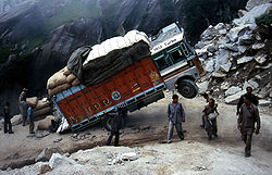
state, and distance from Sarchu to Leh is 257 km (159.7 mi), with total highway length of 479 km (297.6 mi). Owing to the high altitudes and the low-oxygen air, many travelers experience mountain sickness or in some cases even acute mountain sickness.
Leh-Manali Highway was designed, built, constructed and maintained in its entirety by the Indian Army
Indian Army
The Indian Army is the land based branch and the largest component of the Indian Armed Forces. With about 1,100,000 soldiers in active service and about 1,150,000 reserve troops, the Indian Army is the world's largest standing volunteer army...
and is capable of supporting the heaviest of their vehicles.