

Transport in Bhutan
Encyclopedia
Transport in Bhutan comprises approximately 8000 kilometres (4,971 mi) of roads and two airports, Yongphulla Airport
and Paro Airport
, the latter of which serves international flights. As part of Bhutan's infrastructure and modernization programs
, its road system has been under development since the 1960s.
There are no railways or ports as Bhutan is landlocked
.
took six days. Modern road construction began in earnest during the First Development Plan (1961–66). The first 175 kilometres (108.7 mi) paved road was completed in 1962 (a branch road later linked Paro with the Phuntsholing–Thimphu road). Described as a jeep track, it linked Thimphu
and Phuntsholing
with Jaigaon
, West Bengal
. The travel time by motor vehicle from the border to Thimphu had shrunk to six hours. Some 30,000 Indian and Nepalese labourers were imported to build the road with Indian aid at a time when India was bolstering its strategic defence against a possible Chinese invasion. Bhutanese were also obliged to donate labour for the construction work. Another road was also built to connect Tashigang with Tawang, Arunachal Pradesh.
By the mid 1970s, about 1500 kilometres (932.1 mi) of roads had been built, largely by manual labor. There was a linked network of 2280 kilometres (1,416.7 mi) of roads in 1989; at least 1761 kilometres (1,094.2 mi) of these were paved with asphalt, and 1393 kilometres (865.6 mi) were classified as national highways. Despite the construction of surfaced roads linking the principal towns in the south, the mountainous terrain elsewhere makes travel even from one valley to the next quite difficult. Most roads run in river valleys. As part of the Sixth Development Plan, the Department of Public Works, in cooperation with the Indian Border Roads Organization, made plans to construct and upgrade 1000 kilometres (621.4 mi) of roads and to extend the road network through the five major river valleys by 1992. Motorable roads were not the only important development. It was estimated as part of the Fifth Development Plan that Bhutan also needed some 2500 kilometres (1,553.4 mi) of mule tracks to connect the nation's 4,500 settlements.
On January 25, 2005, the King and Indian Prime Minister Manmohan Singh
agreed to carry out a feasibility study for rail links. Possible routes are Hasimara–Phuentsholing with a branch to Pasaka (18 km); Kokrajhar–Gelephu (70 km); Pathsala–Naglam (40 km); Rangla–Darranga–Samdrupjongkar (60 km); and Banarhat–Samtse.
In December 2009, the new King of Bhutan finalised a plan to build a 11 miles (18 km) Indian gauge
rail link funded by India.
The country's primary road is the East-West highway, known locally as the Lateral Road
, which was constructed starting in 1962. The road starts in Phuentsholing on the southwestern Indian border
and terminates in Trashigang
in the far east, with spurs to other main centres such as Paro
, Thimphu
, and Punakha
. The Lateral Road is built to a standard width of only 2.5 metres (8.2 ft) yet must support traffic in both directions (the cost of cutting a wider road through the mountainous Middle Himalayas is prohibitive at this time). Safety barriers, road markings, and signage are sparse. Traffic proceeds at a slow speed, typically around 15 km/h (9.3 mph), to minimise head-on collisions. Road accidents still occur frequently and, because of the steep mountainous topography, are typically horrific. Most of the route between Paro Airport
and Thimphu
has recently been improved to a two lane road.
The Lateral Road traverses are a number of high passes, including Tremo La and Do Chu La. The highest pass on the road is at Chapcha
; the second-highest pass is at Trumshing La in central Bhutan at an altitude of over 3800 m (12,467.2 ft).
Main roadways in western and eastern Bhutan are maintained under contract by DANTAK, an Indian Army
engineering division, and in the rest of the country by the Department of Roads.
Because much of the geology is unstable, there are frequent slips and landslide
s, which are aggravated by both summer monsoon
and winter snowstorm and frost heave conditions. Teams of Indian labourers are housed at work camps in the mountain passes to be dispatched to clear the roads in the event of road blockage. The conditions in the work camps are poor, with the workers reduced to breaking rock into gravel on a piece-rate basis when not clearing the roads. An international aid project is under way to stabilise the worst sections of the road. A major Japan
ese aid project seeks to replace most of the narrow single track bridges with two-way girder spans capable of carrying heavier traffic.
Most freight is moved on eight-ton 300 hp Tata
trucks, which are often overloaded. There is a network of passenger buses, and the most common vehicle in government and private use is the four-wheel-drive pickup.
A national driver licensing system includes a driving test, but this is not rigorous. Government drivers are trained at the Samthang Vocational Training Institute driving school (formerly the National Driving Training Institute) or they learn on the job as 'handy boys'.
The roads do not have traffic light
s; a stoplight installed in Thimphu has been dismantled, and there are recent reports of plans to reinstate it.
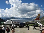
The single runway at Paro Airport is located in a steep-sided valley with restricted VFR approaches. During the monsoon season, flights are often delayed by cloud cover. Drukair is the national carrier, connecting Paro to Bangkok (Thailand), Dhaka (Bangladesh), Kolkata, and Delhi (India), and Kathmandu (Nepal). The airline replaced its two aging BAe 146
four-engined jets in 2004 with faster and more capacious Airbus A319-100 aircraft.
The Royal Bhutanese Government's 10th Five Year Plan
(which covers 2008-2013) includes the building of at least two more domestic airstrips at Bathpalathang in Bumthang District
and near the southern Bhutanese town of Gelephu
in Sarpang District
.
Yongphulla Airport
Yongphulla Airport is a small domestic airport located near Trashigang, a town in the Trashigang District in Bhutan. It is currently one of only two airports in Bhutan....
and Paro Airport
Paro Airport
Paro Airport is the only international airport of Bhutan. The airport is located from Paro in a deep valley on the bank of the Paro river at an elevation of ....
, the latter of which serves international flights. As part of Bhutan's infrastructure and modernization programs
Five-Year Plans of Bhutan
The Five Year Plans of Bhutan are a series of national economic development plans created by the government of Bhutan since 1961.The government of Bhutan has played a pervasive role in its economy and development...
, its road system has been under development since the 1960s.
There are no railways or ports as Bhutan is landlocked
Landlocked
A landlocked country is a country entirely enclosed by land, or whose only coastlines lie on closed seas. There are 48 landlocked countries in the world, including partially recognized states...
.
History
Until 1961, because of the lack of paved roads, travel in Bhutan was by foot or on muleback or horseback. The 205 kilometres (127.4 mi) trek from the Indian border to ThimphuThimphu
Thimphu also spelt Thimpu, is the capital and largest city of Bhutan. It is situated in the western central part of Bhutan and the surrounding valley is one of Bhutan's dzongkhags, the Thimphu District. The city became the capital of Bhutan in 1961...
took six days. Modern road construction began in earnest during the First Development Plan (1961–66). The first 175 kilometres (108.7 mi) paved road was completed in 1962 (a branch road later linked Paro with the Phuntsholing–Thimphu road). Described as a jeep track, it linked Thimphu
Thimphu
Thimphu also spelt Thimpu, is the capital and largest city of Bhutan. It is situated in the western central part of Bhutan and the surrounding valley is one of Bhutan's dzongkhags, the Thimphu District. The city became the capital of Bhutan in 1961...
and Phuntsholing
Phuntsholing
Phuentsholing is a border town in southern Bhutan, and is the administrative seat of Chukha District. The town occupies parts of both Phuentsholing Gewog and Sampheling Gewog. Phuentsholing lies opposite the Indian town of Jaigaon, and cross-border trade has resulted in a thriving local economy...
with Jaigaon
Jaigaon
Jaigaon is a small town in Jalpaiguri district in the Indian state of West Bengal, near the Bhutan border. The town lies at the gateway to Bhutan - Phuentsholing, and is thus a very thriving place of trade...
, West Bengal
West Bengal
West Bengal is a state in the eastern region of India and is the nation's fourth-most populous. It is also the seventh-most populous sub-national entity in the world, with over 91 million inhabitants. A major agricultural producer, West Bengal is the sixth-largest contributor to India's GDP...
. The travel time by motor vehicle from the border to Thimphu had shrunk to six hours. Some 30,000 Indian and Nepalese labourers were imported to build the road with Indian aid at a time when India was bolstering its strategic defence against a possible Chinese invasion. Bhutanese were also obliged to donate labour for the construction work. Another road was also built to connect Tashigang with Tawang, Arunachal Pradesh.
By the mid 1970s, about 1500 kilometres (932.1 mi) of roads had been built, largely by manual labor. There was a linked network of 2280 kilometres (1,416.7 mi) of roads in 1989; at least 1761 kilometres (1,094.2 mi) of these were paved with asphalt, and 1393 kilometres (865.6 mi) were classified as national highways. Despite the construction of surfaced roads linking the principal towns in the south, the mountainous terrain elsewhere makes travel even from one valley to the next quite difficult. Most roads run in river valleys. As part of the Sixth Development Plan, the Department of Public Works, in cooperation with the Indian Border Roads Organization, made plans to construct and upgrade 1000 kilometres (621.4 mi) of roads and to extend the road network through the five major river valleys by 1992. Motorable roads were not the only important development. It was estimated as part of the Fifth Development Plan that Bhutan also needed some 2500 kilometres (1,553.4 mi) of mule tracks to connect the nation's 4,500 settlements.
Rail
As of 2011, Bhutan had no railways.On January 25, 2005, the King and Indian Prime Minister Manmohan Singh
Manmohan Singh
Manmohan Singh is the 13th and current Prime Minister of India. He is the only Prime Minister since Jawaharlal Nehru to return to power after completing a full five-year term. A Sikh, he is the first non-Hindu to occupy the office. Singh is also the 7th Prime Minister belonging to the Indian...
agreed to carry out a feasibility study for rail links. Possible routes are Hasimara–Phuentsholing with a branch to Pasaka (18 km); Kokrajhar–Gelephu (70 km); Pathsala–Naglam (40 km); Rangla–Darranga–Samdrupjongkar (60 km); and Banarhat–Samtse.
In December 2009, the new King of Bhutan finalised a plan to build a 11 miles (18 km) Indian gauge
Indian gauge
Indian gauge is a track gauge commonly used in India, Pakistan, Bangladesh, Sri Lanka, Argentina and Chile. It is also the gauge that is used on BART , in northern California.- Scotland :...
rail link funded by India.
Roadways
- Total: 8050 km (5,002.1 mi)
- Paved: 4991 km (3,101.3 mi)
- Unpaved: 3059 km (1,900.8 mi) (2003)
The country's primary road is the East-West highway, known locally as the Lateral Road
Lateral Road
Bhutan's Lateral Road is its primary east-west corridor, connecting Phuentsholing in the southwest to Trashigang in the east. In between, the Lateral Road runs directly through Wangdue Phodrang, Trongsa, and other population centers...
, which was constructed starting in 1962. The road starts in Phuentsholing on the southwestern Indian border
India
India , officially the Republic of India , is a country in South Asia. It is the seventh-largest country by geographical area, the second-most populous country with over 1.2 billion people, and the most populous democracy in the world...
and terminates in Trashigang
Trashigang
Trashigang District is Bhutan's easternmost dzongkhag .-Culture:...
in the far east, with spurs to other main centres such as Paro
Paro, Bhutan
-History:Rinpung Dzong a fortress-monastery overlooking the Paro valley has a long history. A monastery was first built on the site by Padma Sambhava at the beginning of the tenth century, but it wasn't until 1646 that Ngawang Namgyal built a larger monastery on the old foundations, and for...
, Thimphu
Thimphu
Thimphu also spelt Thimpu, is the capital and largest city of Bhutan. It is situated in the western central part of Bhutan and the surrounding valley is one of Bhutan's dzongkhags, the Thimphu District. The city became the capital of Bhutan in 1961...
, and Punakha
Punakha
thumb|right|Punakha Dzong and the [[Mo Chhu]]Punakha is the administrative centre of Punakha dzongkhag, one of the 20 districts of Bhutan. Punakha was the capital of Bhutan and the seat of government until 1955, when the capital was moved to Thimphu. It is about 72 km away from Thimphu and it...
. The Lateral Road is built to a standard width of only 2.5 metres (8.2 ft) yet must support traffic in both directions (the cost of cutting a wider road through the mountainous Middle Himalayas is prohibitive at this time). Safety barriers, road markings, and signage are sparse. Traffic proceeds at a slow speed, typically around 15 km/h (9.3 mph), to minimise head-on collisions. Road accidents still occur frequently and, because of the steep mountainous topography, are typically horrific. Most of the route between Paro Airport
Paro Airport
Paro Airport is the only international airport of Bhutan. The airport is located from Paro in a deep valley on the bank of the Paro river at an elevation of ....
and Thimphu
Thimphu
Thimphu also spelt Thimpu, is the capital and largest city of Bhutan. It is situated in the western central part of Bhutan and the surrounding valley is one of Bhutan's dzongkhags, the Thimphu District. The city became the capital of Bhutan in 1961...
has recently been improved to a two lane road.
The Lateral Road traverses are a number of high passes, including Tremo La and Do Chu La. The highest pass on the road is at Chapcha
Chapcha Gewog
Chapcha Gewog is a gewog of Chukha District, Bhutan. The gewog has an area of 112.6 square kilometres and contains 11 villages....
; the second-highest pass is at Trumshing La in central Bhutan at an altitude of over 3800 m (12,467.2 ft).
Main roadways in western and eastern Bhutan are maintained under contract by DANTAK, an Indian Army
Indian Army
The Indian Army is the land based branch and the largest component of the Indian Armed Forces. With about 1,100,000 soldiers in active service and about 1,150,000 reserve troops, the Indian Army is the world's largest standing volunteer army...
engineering division, and in the rest of the country by the Department of Roads.
Because much of the geology is unstable, there are frequent slips and landslide
Landslide
A landslide or landslip is a geological phenomenon which includes a wide range of ground movement, such as rockfalls, deep failure of slopes and shallow debris flows, which can occur in offshore, coastal and onshore environments...
s, which are aggravated by both summer monsoon
Monsoon
Monsoon is traditionally defined as a seasonal reversing wind accompanied by corresponding changes in precipitation, but is now used to describe seasonal changes in atmospheric circulation and precipitation associated with the asymmetric heating of land and sea...
and winter snowstorm and frost heave conditions. Teams of Indian labourers are housed at work camps in the mountain passes to be dispatched to clear the roads in the event of road blockage. The conditions in the work camps are poor, with the workers reduced to breaking rock into gravel on a piece-rate basis when not clearing the roads. An international aid project is under way to stabilise the worst sections of the road. A major Japan
Japan
Japan is an island nation in East Asia. Located in the Pacific Ocean, it lies to the east of the Sea of Japan, China, North Korea, South Korea and Russia, stretching from the Sea of Okhotsk in the north to the East China Sea and Taiwan in the south...
ese aid project seeks to replace most of the narrow single track bridges with two-way girder spans capable of carrying heavier traffic.
Most freight is moved on eight-ton 300 hp Tata
Tata Motors
Tata Motors Limited is an Indian multinational automotive corporation headquartered in Mumbai, India. Part of the Tata Group, it was formerly known as TELCO...
trucks, which are often overloaded. There is a network of passenger buses, and the most common vehicle in government and private use is the four-wheel-drive pickup.
A national driver licensing system includes a driving test, but this is not rigorous. Government drivers are trained at the Samthang Vocational Training Institute driving school (formerly the National Driving Training Institute) or they learn on the job as 'handy boys'.
The roads do not have traffic light
Traffic light
Traffic lights, which may also be known as stoplights, traffic lamps, traffic signals, signal lights, robots or semaphore, are signalling devices positioned at road intersections, pedestrian crossings and other locations to control competing flows of traffic...
s; a stoplight installed in Thimphu has been dismantled, and there are recent reports of plans to reinstate it.
Airports
- Total: 2 (2010)
- Paved: 1 (Paro Airport), runway area between 1524 and 2437 m (5,000 and 7,995.4 ft))
- Unpaved: 1 (Yongphulla Airport runway area between 914 and 1523 m (2,998.7 and 4,996.7 ft)).
The single runway at Paro Airport is located in a steep-sided valley with restricted VFR approaches. During the monsoon season, flights are often delayed by cloud cover. Drukair is the national carrier, connecting Paro to Bangkok (Thailand), Dhaka (Bangladesh), Kolkata, and Delhi (India), and Kathmandu (Nepal). The airline replaced its two aging BAe 146
BAe 146
The British Aerospace 146 is a medium-sized commercial airliner formerly manufactured in the United Kingdom by British Aerospace, later part of BAE Systems. Production ran from 1983 until 2002. Manufacture of an improved version known as the Avro RJ began in 1992...
four-engined jets in 2004 with faster and more capacious Airbus A319-100 aircraft.
The Royal Bhutanese Government's 10th Five Year Plan
Five-Year Plans of Bhutan
The Five Year Plans of Bhutan are a series of national economic development plans created by the government of Bhutan since 1961.The government of Bhutan has played a pervasive role in its economy and development...
(which covers 2008-2013) includes the building of at least two more domestic airstrips at Bathpalathang in Bumthang District
Bumthang District
Bumthang District is one of the 20 dzongkhag comprising Bhutan. It is the most historic dzongkhag if the number of ancient temples and sacred sites is counted...
and near the southern Bhutanese town of Gelephu
Gelephu
Gelephu is a town in Sarpang District in Bhutan. It is located on the Indian border, about 30 km to the east of Sarpang, the Dzongkhag headquarters , and has a population of 9,199 as per 2005 census.Gelephu was selected as a site for Bhutan's second international airport project, but it was...
in Sarpang District
Sarpang District
Sarpang District is one of the 20 dzongkhags comprising Bhutan.-Languages:...
.