
Torugart Pass
Encyclopedia
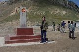
Torugart Pass is a pass
in the Tian Shan
mountain range on the border between the Naryn Province
of Kyrgyzstan
and the Xinjiang Autonomous Region
of China
.
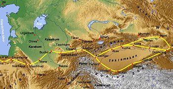
The scenic Lake of Chatyr-Kul
lies near the pass on the Kyrgyz side. The road to Naryn
and then to Balykshy and Bishkek
—stretching for some 400 km (248.5 mi)—is narrow and in winter often impassable due to heavy snowfall and frequent avalanche
s. On the Chinese side, the Torugart Port of Entry (吐尔尕特口岸), where travelers must clear for customs, is located about 110 km (68.4 mi) from the pass itself in Ulugqat County of the Kizilsu Kirghiz Autonomous Prefecture. Distances from the pass to major cities are: 110 km (68.4 mi) to Ulugqat, 165 km (102.5 mi) to Kashgar
, 170 kilometres (105.6 mi) to Artux
and some 1630 km (1,012.8 mi) to Urumqi
.
Russia and China first established a port of entry at the Torugart Pass in 1881. In 1906, Russia's Sino-Russian Transport Bank financed the construction of the road from the pass to Kashgar for 20 million rubles. In 1952, the Torugart Pass replaced the Irkeshtam
Pass, which lies some 165 km (102.5 mi) southwest, as the primary overland link between Xinjiang and the then-Soviet Kyrgyz Republic
. The pass was closed in 1969 due to the Sino-Soviet Split
and reopened again in 1983. In 1995, the Torugart Port of Entry was relocated to a lower elevation (2,000m), closer to Kashgar
, some 57 km (35.4 mi) away.
The Chinese and Central Asian governments are planning to open the pass to nationals from third countries and considering the construction of a railway through the pass that would link Kashgar
and the Ferghana Valley.
Mountain pass
A mountain pass is a route through a mountain range or over a ridge. If following the lowest possible route, a pass is locally the highest point on that route...
in the Tian Shan
Tian Shan
The Tian Shan , also spelled Tien Shan, is a large mountain system located in Central Asia. The highest peak in the Tian Shan is Victory Peak , ....
mountain range on the border between the Naryn Province
Naryn Province
Naryn Province is the largest province of Kyrgyzstan. Its capital is Naryn. The province was established on November 21, 1939 as Tien-Shan Province. On December 20, 1962 the province was dissolved, but on December 11, 1970 re-established again...
of Kyrgyzstan
Kyrgyzstan
Kyrgyzstan , officially the Kyrgyz Republic is one of the world's six independent Turkic states . Located in Central Asia, landlocked and mountainous, Kyrgyzstan is bordered by Kazakhstan to the north, Uzbekistan to the west, Tajikistan to the southwest and China to the east...
and the Xinjiang Autonomous Region
Xinjiang
Xinjiang is an autonomous region of the People's Republic of China. It is the largest Chinese administrative division and spans over 1.6 million km2...
of China
People's Republic of China
China , officially the People's Republic of China , is the most populous country in the world, with over 1.3 billion citizens. Located in East Asia, the country covers approximately 9.6 million square kilometres...
.
The scenic Lake of Chatyr-Kul
Chatyr-Kul
Chatyr-Kul is an endorheic alpine lake in the Tian Shan mountains in At-Bashi District of Naryn Province, Kyrgyzstan; it lies in the lower part of Chatyr-Kul Depression near the Torugart Pass border crossing into China. The name of the lake means “Celestial Lake” in Kyrgyz...
lies near the pass on the Kyrgyz side. The road to Naryn
Naryn
Naryn is the provincial administrative center of the Naryn Province in central Kyrgyzstan, with a population of 34,822 . It is situated on both banks of the Naryn River, , which cuts a picturesque gorge through the town...
and then to Balykshy and Bishkek
Bishkek
Bishkek , formerly Pishpek and Frunze, is the capital and the largest city of Kyrgyzstan.Bishkek is also the administrative centre of Chuy Province which surrounds the city, even though the city itself is not part of the province but rather a province-level unit of Kyrgyzstan.The name is thought to...
—stretching for some 400 km (248.5 mi)—is narrow and in winter often impassable due to heavy snowfall and frequent avalanche
Avalanche
An avalanche is a sudden rapid flow of snow down a slope, occurring when either natural triggers or human activity causes a critical escalating transition from the slow equilibrium evolution of the snow pack. Typically occurring in mountainous terrain, an avalanche can mix air and water with the...
s. On the Chinese side, the Torugart Port of Entry (吐尔尕特口岸), where travelers must clear for customs, is located about 110 km (68.4 mi) from the pass itself in Ulugqat County of the Kizilsu Kirghiz Autonomous Prefecture. Distances from the pass to major cities are: 110 km (68.4 mi) to Ulugqat, 165 km (102.5 mi) to Kashgar
Kashgar
Kashgar or Kashi is an oasis city with approximately 350,000 residents in the western part of the Xinjiang Uyghur Autonomous Region of the People's Republic of China. Kashgar is the administrative centre of Kashgar Prefecture which has an area of 162,000 km² and a population of approximately...
, 170 kilometres (105.6 mi) to Artux
Artux
Artux, Atush or Atushi is a county-level city in Xinjiang. The area is 15,509 km² and the total population is 200,000 . Artux is the seat of Kizilsu Kirghiz Autonomous Prefecture....
and some 1630 km (1,012.8 mi) to Urumqi
Ürümqi
Ürümqi , formerly Tihwa , is the capital of Xinjiang Uyghur Autonomous Region of the People's Republic of China, in the northwest of the country....
.
Russia and China first established a port of entry at the Torugart Pass in 1881. In 1906, Russia's Sino-Russian Transport Bank financed the construction of the road from the pass to Kashgar for 20 million rubles. In 1952, the Torugart Pass replaced the Irkeshtam
Irkeshtam
Irkeshtam is a village east of the Alay Valley in southern Osh Province, Kyrgyzstan. It is one of the two main border crossings between Kyrgyzstan and Xinjiang, China, the other being Torugart, some to the northeast...
Pass, which lies some 165 km (102.5 mi) southwest, as the primary overland link between Xinjiang and the then-Soviet Kyrgyz Republic
Kirghiz Soviet Socialist Republic
The Kirghiz Soviet Socialist Republic , also known as the Kirghiz SSR, the Kyrgyz SSR, or even Kirghizia, was one of republics that made up the Soviet Union...
. The pass was closed in 1969 due to the Sino-Soviet Split
Sino-Soviet split
In political science, the term Sino–Soviet split denotes the worsening of political and ideologic relations between the People's Republic of China and the Union of Soviet Socialist Republics during the Cold War...
and reopened again in 1983. In 1995, the Torugart Port of Entry was relocated to a lower elevation (2,000m), closer to Kashgar
Kashgar
Kashgar or Kashi is an oasis city with approximately 350,000 residents in the western part of the Xinjiang Uyghur Autonomous Region of the People's Republic of China. Kashgar is the administrative centre of Kashgar Prefecture which has an area of 162,000 km² and a population of approximately...
, some 57 km (35.4 mi) away.
The Chinese and Central Asian governments are planning to open the pass to nationals from third countries and considering the construction of a railway through the pass that would link Kashgar
Kashgar
Kashgar or Kashi is an oasis city with approximately 350,000 residents in the western part of the Xinjiang Uyghur Autonomous Region of the People's Republic of China. Kashgar is the administrative centre of Kashgar Prefecture which has an area of 162,000 km² and a population of approximately...
and the Ferghana Valley.
See also
- Geography of ChinaGeography of ChinaChina stretches some across the East Asian landmass bordering the East China Sea, Korea Bay, Yellow Sea, and South China Sea, between North Korea and Vietnam in a changing configuration of broad plains, expansive deserts, and lofty mountain ranges, including vast areas of inhospitable terrain...
- Geography of KyrgyzstanGeography of KyrgyzstanKyrgyzstan is a landlocked nation in Central Asia, west of the People's Republic of China. Less than a seventh the size of Mongolia, at 199,951 square kilometers, Kyrgyzstan is one of the smaller Central Asian states...
- Geostrategy in Central AsiaGeostrategy in Central AsiaCentral Asia has long been a geostrategic location because of its proximity to the interests of several great powers.-Strategic geography:...