

Naryn Province
Encyclopedia
Naryn Province is the largest province (oblast
) of Kyrgyzstan
. Its capital is Naryn
. The province was established on November 21, 1939 as Tien-Shan Province. On December 20, 1962 the province was dissolved, but on December 11, 1970 re-established again. On October 5, 1988 it was unified with Issyk-Kul Province, and, finally, on December 14, 1990 it got back its present name: Naryn Province.
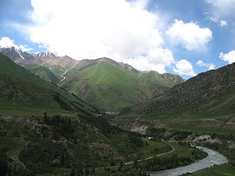
The main highway runs from the Chinese border at Torugart Pass
north to Balykchy
on Issyk Kul Lake. It is known as the location of Son-Kul Lake and Chatyr-Kul Lake and Tash Rabat
.
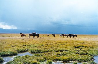
 The population of Naryn oblast is 99% Kyrgyz. The economy is dominated by animal herding (sheep, horses, yak
s), with wool and meat as the main products. Mining of various minerals developed during the Soviet era has largely been abandoned as uneconomical. Today the oblast is considered to be the poorest region in the country, but also the most typically Kirgyz. It boasts beautiful mountains, alpine pastures and Son-Kul Lake which during summer months attracts large herds of sheep and horses with their herders and their yurts.
Oblast
Oblast is a type of administrative division in Slavic countries, including some countries of the former Soviet Union. The word "oblast" is a loanword in English, but it is nevertheless often translated as "area", "zone", "province", or "region"...
) of Kyrgyzstan
Kyrgyzstan
Kyrgyzstan , officially the Kyrgyz Republic is one of the world's six independent Turkic states . Located in Central Asia, landlocked and mountainous, Kyrgyzstan is bordered by Kazakhstan to the north, Uzbekistan to the west, Tajikistan to the southwest and China to the east...
. Its capital is Naryn
Naryn
Naryn is the provincial administrative center of the Naryn Province in central Kyrgyzstan, with a population of 34,822 . It is situated on both banks of the Naryn River, , which cuts a picturesque gorge through the town...
. The province was established on November 21, 1939 as Tien-Shan Province. On December 20, 1962 the province was dissolved, but on December 11, 1970 re-established again. On October 5, 1988 it was unified with Issyk-Kul Province, and, finally, on December 14, 1990 it got back its present name: Naryn Province.
The main highway runs from the Chinese border at Torugart Pass
Torugart Pass
Torugart Pass is a pass in the Tian Shan mountain range on the border between the Naryn Province of Kyrgyzstan and the Xinjiang Autonomous Region of China.The scenic Lake of Chatyr-Kul lies near the pass on the Kyrgyz side...
north to Balykchy
Balykchy
Balykchy is a town with a population about 40,000 people located at the western end of Lake Issyk-Kul in Kyrgyzstan, at and an elevation of about 1,900 metres...
on Issyk Kul Lake. It is known as the location of Son-Kul Lake and Chatyr-Kul Lake and Tash Rabat
Tash Rabat
Tash Rabat is a well-preserved 15th century stone caravanserai in At Bashy district, Naryn Province, Kyrgyzstan. Some argue that it was originally a Nestorian or Buddhist monastery going back to the tenth century. It is located somewhat east of the main north-south highway.To the south is Lake...
.
Yak
The yak, Bos grunniens or Bos mutus, is a long-haired bovine found throughout the Himalayan region of south Central Asia, the Tibetan Plateau and as far north as Mongolia and Russia. In addition to a large domestic population, there is a small, vulnerable wild yak population...
s), with wool and meat as the main products. Mining of various minerals developed during the Soviet era has largely been abandoned as uneconomical. Today the oblast is considered to be the poorest region in the country, but also the most typically Kirgyz. It boasts beautiful mountains, alpine pastures and Son-Kul Lake which during summer months attracts large herds of sheep and horses with their herders and their yurts.
Basic Socio-Economic Indicators
- Population: 271,000 (assessment for 1 January 2009) including 17.4% - urban, and 82.6% - rural population
- Employed population: 89,300 (2008)
- Registered Unemployed Population: 6,922 (2008)
- Export: 0.9 million US dollars (2008)
- Import: 4.0 million US dollars (2008)
- Direct Foreign Investments: 1,1 million US dollars (in 2008)
Districts of Naryn
Naryn Province is divided administratively into 5 districts| District | Capital |
|---|---|
| Ak-Talaa District Ak-Talaa District Ak-Talaa is a raion of Naryn Province in Kyrgyzstan. The capital lies at Baetov. :-Rural communities, and villages:In total, Ak-Talaa District include 13 rural communities . Each rural community can consist of one or several villages... |
Baetov Baetov Baetov , is a village and a center of Ak-Talaa District in the Naryn Province of Kyrgyzstan. It lies on the Naryn valley road about half-way from Naryn to Kazarman. At this point, a road branches south to Baetov on an outwash plain in the mountains. A jeep road goes south over a 3,268m pass to... |
| At-Bashi District At-Bashi District At-Bashi is a raion of Naryn Province in Kyrgyzstan. The capital lies at At-Bashi.:-Towns, rural communities, and villages:In total, At-Bashi District include 10 rural communities . Each rural community includes one or several villages... |
At-Bashi At-Bashi At-Bashi is a village in the Naryn Province of Kyrgyzstan, about 35km southwest of Naryn on the main highway to the Torugart Pass. It is the seat of At-Bashi District. The At-Bashi Range to the south extends to Lake Chatyr-Kul. The At-Bashi River comes in from the east and then runs northwest... |
| Jumgal District Jumgal District Jumgal is a raion of Naryn Province in central Kyrgyzstan. The capital lies at Chaek. The river Jumgal is situated in this district , it is a tributary of Kökömeren River, the latter is tributary to Naryn river.-Populated places:... |
Chaek Chaek Chaek is a village in Naryn Province of Kyrgyzstan on the A361 highway which crosses the north of the province. It is about 100km west of Kochkor and 45km west of Lake Son-Kul. It is the largest of several villages in an agricultural valley. Further west the scenery becomes more dramatic.... |
| Kochkor District Kochkor District Kochkor is a raion of Naryn Province in northern-central Kyrgyzstan. The capital lies at Kochkor.:-Populated places:In total, Kochkor District include 11 rural communities . Each rural community includes one or several villages... |
Kochkor Kochkor Kochkor is a town in northern Naryn Province of Kyrgyzstan. It is the capital of Kochkor District. Former names were Stolypin and Kochkorka. Altitude 1,800m. Population 14,000. It is on the main A365 highway from Torugart Pass north to Bishkek. About 7 km west A361 branches west toward... |
| Naryn District | Naryn Naryn Naryn is the provincial administrative center of the Naryn Province in central Kyrgyzstan, with a population of 34,822 . It is situated on both banks of the Naryn River, , which cuts a picturesque gorge through the town... |