

Tiniroto
Encyclopedia
Gisborne, New Zealand
-Economy:The harbour was host to many ships in the past and had developed as a river port to provide a more secure location for shipping compared with the open roadstead of Poverty Bay which can be exposed to southerly swells. A meat works was sited beside the harbour and meat and wool was shipped...
to Wairoa
Wairoa
Wairoa is a town in New Zealand's North Island. It is the northernmost town in the Hawke's Bay region, and is located on the northern shore of Hawke Bay at the mouth of the Wairoa River and to the west of Mahia Peninsula...
in the eastern part of the North Island
North Island
The North Island is one of the two main islands of New Zealand, separated from the much less populous South Island by Cook Strait. The island is in area, making it the world's 14th-largest island...
of New Zealand
New Zealand
New Zealand is an island country in the south-western Pacific Ocean comprising two main landmasses and numerous smaller islands. The country is situated some east of Australia across the Tasman Sea, and roughly south of the Pacific island nations of New Caledonia, Fiji, and Tonga...
. The population of the Tiniroto district at the 2001 New Zealand Census of Population and Dwellings
New Zealand Census of Population and Dwellings
The New Zealand government department Statistics New Zealand conducts a census of population and dwellings every five years. The census scheduled for 2011 was cancelled due to circumstances surrounding the February 2011 Christchurch earthquake, however, and legislation introduced to hold the next...
was 2,142, but the district encompasses a vast rural area and Tiniroto itself is defined as a lowly populated locality.
Geography
Tiniroto is situated 61 km from Gisborne and 44 km from Wairoa on the inland road, also called Tiniroto Road. A larger road from Gisborne to Wairoa (SH2) runs more closely to the coast.Riding along the Tiniroto Road from Gisborne one first passes the Poverty Bay Flats (or flats?). After a few km the road starts winding up, and at 24 km it passes Gentle Annie Summit. The summit rises to 360 m and gives a panoramic view of Poverty Bay and Gisborne.
At 29 km lies the little community of Waerenga-o-kuri.
The road bends down to the valley of Hangaroa river.
At 53 km an unpaved road leads into Doneraille Park.
From Tiniroto further along the road one passes Mt. Whakapunake (961 m high) north and west. At 70 km lies Te Reinga, near the confluence of Hangaroa River and Ruakituri River. They form Te Reinga Falls.
At Frasertown
Frasertown
Frasertown is a small settlement in the northern Hawke's Bay Region of New Zealand's eastern North Island. It is located inland from Wairoa at the junction of SH38, and the inland route to Gisborne....
, 8 km from Wairoa, the Tiniroto Road connects to SH38, that comes from Rotorua
Rotorua
Rotorua is a city on the southern shores of the lake of the same name, in the Bay of Plenty region of the North Island of New Zealand. The city is the seat of the Rotorua District, a territorial authority encompassing the city and several other nearby towns...
, Murapara and Lake Waikaremoana
Lake Waikaremoana
Lake Waikaremoana is located in Te Urewera National Park in the North Island of New Zealand, 60 kilometres northwest of Wairoa and 80 kilometres southwest of Gisborne. It covers an area of 54 km². From the Maori Waikaremoana translates as 'sea of rippling waters'The lake lies in the heart of Tuhoe...
.
Lakes
Tiniroto means “Many Lakes (?)” in MāoriMaori language
Māori or te reo Māori , commonly te reo , is the language of the indigenous population of New Zealand, the Māori. It has the status of an official language in New Zealand...
. There are a number of lakes around Tiniroto that originate from landslides thousands years ago.
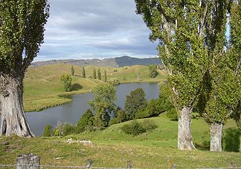
The largest lake lies close to the village. At Hackfalls Station one finds Lake Karangata with an area of about 10 ha and Lake Kaikiore with and area of about 5 ha.
There are a number of other lakes of different sizes in the surroundings. These lakes offer good fishing opportunities (for trout
Trout
Trout is the name for a number of species of freshwater and saltwater fish belonging to the Salmoninae subfamily of the family Salmonidae. Salmon belong to the same family as trout. Most salmon species spend almost all their lives in salt water...
).
Village
The village of Tiniroto is small. It has a primary school and it has a tavern, with overnight accommodation. The tavern is adjected to a post office.Hackfalls Arboretum
A few kilometers from Tiniroto Bob BerryBob Berry (dendrologist)
Robert James Berry is a New Zealand dendrologist who founded Hackfalls Arboretum at his farm in Tiniroto, Gisborne. The arboretum is now known for having one of the largest collections of Mexican oaks in the world. During the 1950s and 1960s he was in regular contact with William Douglas Cook,...
founded Hackfalls Arboretum
Hackfalls Arboretum
Hackfalls Arboretum is an arboretum in New Zealand. It was founded in the 1950s by Bob Berry. Hackfalls Arboretum is part of “Hackfalls Station”, a sheep and cattle farm of about 10 square kilometres, owned by the Berry family. Hackfalls is situated in Tiniroto, a tiny village in the eastern part...
. On about 50 ha it contains a collection of some 4000 trees.