
Tin Mine Falls
Encyclopedia
Tin Mine Falls is a waterfall
located in the remote Pilot Wilderness Area, part of Kosciuszko National Park
in southern New South Wales
, Australia
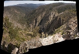
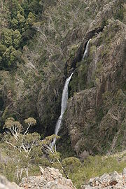
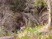
. Described from top to bottom, the falls consist of non-segmented tiered cascades over bedrock
with a few smaller plunges
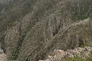
, followed by a single large plunge into a pool. The falls are recessed into a punchbowl feature making it impossible to view the entire waterfall from a single location on the ground.

photographs are known except those on this page). The closest walking path is the Cascade Fire Trail, which runs South from the Alpine Way just West of Thredbo Village. Satellite imagery of the site is available via Google Maps.
A number of sources list the height of Tin Mine Falls as 459m (1,381') or 360m (1080'), and quote a story concerning the origin of this figure: "The falls were apparently measured in 1990 by a Dr. John Pease ... using a plumb line"
If true, this height would make Tin Mine Falls the tallest waterfall in Australia and 137th tallest in the world. However, it conflicts with official data from Geosciences Australia
, who list the 3 tallest waterfalls in Australia as:
Note the distinction between longest-single-drop height and overall height - many observers will only include vertical plunges when assessing the height of a waterfall.
of the area can be explained by the inclusion of a long series of cascades upstream from the waterfall
. Therefore the definition of a waterfall and the chosen measuring process will determine the measured height.
 A thorough and widely referenced process for measuring the height of a waterfall can be found here. The crux of the process is that although shallow cascades can be included in a waterfall, they are excluded when the water is not flowing over bedrock. Simpler methods are only really suited to single drop waterfalls.
 The lower limit of Tin Mine falls is easy to pinpoint due to the final plunge into a large pool, from which the water flows smoothly. The upper limit is less decisive, because the stream changes from a relatively flat meandering course to the plunge quite gradually. However, a distinct and drastic change occurs at one point where the water transitions from a series of small connected pools with pebbled/mud bottoms to a smooth and fast slide over bedrock.
 Above this point, the water is not flowing over bedrock, and is not losing height quickly.
to the image plane
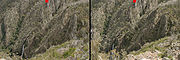
of the photographer. The distance between the centres of the flags was measured with a tape-measure to be 3.1m. These flags are visible in the expedition photographs and provide a scale for the images.
is perpendicular
to the ground plane (an imaginary plane Tangential to the surface of the Earth
), and that the waterfall flows on a plane that is parallel to the image plane, we can estimate the height by measuring the vertical separation of waterfall head and base in
pixel
s, then scaling using the known distance between the flags.
In photograph the flag centres are located at (2663,131) and (2631,132) using graphics coordinates with origin at top-left. The bottom of the falls is at approximately (796,1932), therefore the height in pixels is 1800. If 32 pixels is 3.1m, then 1800 pixels is 174m. Since the flags were positioned 8m above the top of the falls, the height can be estimated at 166m.
 The photographer captured stereo pairs of photographs
of the waterfall site with an unknown baseline
. By matching interest points
between the stereo images, it is possible to produce a disparity map
indicating unscaled distance from the camera to any interest point. It is then possible to scale this 3 dimensional model using the positions of the flag scale markers. Finally, a new plane was defined such as to fit interest points generated by the final plunge and at the head of the falls - the base of the falls is closer to the viewer than the head. A parallelogram
was fixed to this plane such that its limits
matched those of the falls in the photograph. The height of the parallelogram was extracted as 185.5m. Subtracting the extra 8m from the top to the flags gives an overall height estimate of 178m.
A video of the 3-D reconstruction can be found here, showing the plane fitted to the waterfall and matched interest points.
but contradicts Geosciences Australia's list of the tallest
waterfalls in Australia (this would make Tin Mine Falls the 3rd highest on the continent
). Unless the upper limit of the falls is fixed well upstream, to include a long section of shallow-slope non-bedrock streambed, the rumoured height of 360-459m cannot be substantiated.
Waterfall
A waterfall is a place where flowing water rapidly drops in elevation as it flows over a steep region or a cliff.-Formation:Waterfalls are commonly formed when a river is young. At these times the channel is often narrow and deep. When the river courses over resistant bedrock, erosion happens...
located in the remote Pilot Wilderness Area, part of Kosciuszko National Park
Kosciuszko National Park
Kosciuszko National Park covers 690,000 hectares and contains mainland Australia's highest peak, Mount Kosciuszko for which it is named, and Cabramurra the highest town in Australia...
in southern New South Wales
New South Wales
New South Wales is a state of :Australia, located in the east of the country. It is bordered by Queensland, Victoria and South Australia to the north, south and west respectively. To the east, the state is bordered by the Tasman Sea, which forms part of the Pacific Ocean. New South Wales...
, Australia
Australia
Australia , officially the Commonwealth of Australia, is a country in the Southern Hemisphere comprising the mainland of the Australian continent, the island of Tasmania, and numerous smaller islands in the Indian and Pacific Oceans. It is the world's sixth-largest country by total area...
. Described from top to bottom, the falls consist of non-segmented tiered cascades over bedrock
Bedrock
In stratigraphy, bedrock is the native consolidated rock underlying the surface of a terrestrial planet, usually the Earth. Above the bedrock is usually an area of broken and weathered unconsolidated rock in the basal subsoil...
with a few smaller plunges
Waterfall
A waterfall is a place where flowing water rapidly drops in elevation as it flows over a steep region or a cliff.-Formation:Waterfalls are commonly formed when a river is young. At these times the channel is often narrow and deep. When the river courses over resistant bedrock, erosion happens...
, followed by a single large plunge into a pool. The falls are recessed into a punchbowl feature making it impossible to view the entire waterfall from a single location on the ground.
Access
Since no roads or trails go to the falls, access is quite difficult and the falls are rarely visited or photographed (no publicphotographs are known except those on this page). The closest walking path is the Cascade Fire Trail, which runs South from the Alpine Way just West of Thredbo Village. Satellite imagery of the site is available via Google Maps.
Height
The height of Tin Mine falls is a matter of some controversy, due to two factors:- uncertainty in the precise definition of a waterfall and where it begins and ends
- the lack of photographs and other material to documenting Tin Mine Falls
A number of sources list the height of Tin Mine Falls as 459m (1,381') or 360m (1080'), and quote a story concerning the origin of this figure: "The falls were apparently measured in 1990 by a Dr. John Pease ... using a plumb line"
If true, this height would make Tin Mine Falls the tallest waterfall in Australia and 137th tallest in the world. However, it conflicts with official data from Geosciences Australia
Geoscience Australia
Geoscience Australia is an agency of the Australian federal government. It carries out geoscientific research.On a user pays basis it produces geospatial products such as topographic maps and satellite imagery.-History:...
, who list the 3 tallest waterfalls in Australia as:
- Wallaman FallsWallaman FallsThe Wallaman Falls are notable for their single-drop of 268 metres, which is Australia's highest permanent waterfall. The pool at the end of the waterfall is 20 metres deep....
- QueenslandQueenslandQueensland is a state of Australia, occupying the north-eastern section of the mainland continent. It is bordered by the Northern Territory, South Australia and New South Wales to the west, south-west and south respectively. To the east, Queensland is bordered by the Coral Sea and Pacific Ocean...
, 305m - Wollomombi Waterfall - New South WalesNew South WalesNew South Wales is a state of :Australia, located in the east of the country. It is bordered by Queensland, Victoria and South Australia to the north, south and west respectively. To the east, the state is bordered by the Tasman Sea, which forms part of the Pacific Ocean. New South Wales...
, 220m (100m single drop) - Ellenborough FallsEllenborough FallsEllenborough Falls is a waterfall on the headwaters of the Ellenborough River in New South Wales, Australia. It is situated in the Greater Taree area and is near Elands and Comboyne, on the Bulga Plateau.-Features:...
- New South WalesNew South WalesNew South Wales is a state of :Australia, located in the east of the country. It is bordered by Queensland, Victoria and South Australia to the north, south and west respectively. To the east, the state is bordered by the Tasman Sea, which forms part of the Pacific Ocean. New South Wales...
160m (single drop)
Note the distinction between longest-single-drop height and overall height - many observers will only include vertical plunges when assessing the height of a waterfall.
Measuring Tin Mine Falls
It has been suggested that the conflict between the reported height and the surveyed topographyTopography
Topography is the study of Earth's surface shape and features or those ofplanets, moons, and asteroids...
of the area can be explained by the inclusion of a long series of cascades upstream from the waterfall
Waterfall
A waterfall is a place where flowing water rapidly drops in elevation as it flows over a steep region or a cliff.-Formation:Waterfalls are commonly formed when a river is young. At these times the channel is often narrow and deep. When the river courses over resistant bedrock, erosion happens...
. Therefore the definition of a waterfall and the chosen measuring process will determine the measured height.
Measurement from photographs
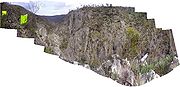
An expedition to capture photographs of the falls was undertaken by Dr. David Rawlinson, Adam Ferguson, Matthew Farrell, Nicholas Wright, Tadhgh Knaggs, and Travis Hogg between 16 and 20 October 2008. If the upper limit of the falls is accepted as described above, the expedition photographs may be used to estimate the height of the falls. Alternatively, the photographs allow readers to judge the height of some subsection of the falls independently.Photograph scale
A pair of fluorescent yellow flags was positioned 10m above the head of the falls by the photographers. The flags were arranged to lie on a plane parallelParallel (geometry)
Parallelism is a term in geometry and in everyday life that refers to a property in Euclidean space of two or more lines or planes, or a combination of these. The assumed existence and properties of parallel lines are the basis of Euclid's parallel postulate. Two lines in a plane that do not...
to the image plane
Image plane
In 3D computer graphics, the image plane is that plane in the world which is identified with the plane of the monitor. If one makes the analogy of taking a photograph to rendering a 3D image, the surface of the film is the image plane. In this case, the viewing transformation is a projection that...
of the photographer. The distance between the centres of the flags was measured with a tape-measure to be 3.1m. These flags are visible in the expedition photographs and provide a scale for the images.
Using Pythagoras' Theorem
If we additionally assume that the image planeImage plane
In 3D computer graphics, the image plane is that plane in the world which is identified with the plane of the monitor. If one makes the analogy of taking a photograph to rendering a 3D image, the surface of the film is the image plane. In this case, the viewing transformation is a projection that...
is perpendicular
Perpendicular
In geometry, two lines or planes are considered perpendicular to each other if they form congruent adjacent angles . The term may be used as a noun or adjective...
to the ground plane (an imaginary plane Tangential to the surface of the Earth
Earth
Earth is the third planet from the Sun, and the densest and fifth-largest of the eight planets in the Solar System. It is also the largest of the Solar System's four terrestrial planets...
), and that the waterfall flows on a plane that is parallel to the image plane, we can estimate the height by measuring the vertical separation of waterfall head and base in
pixel
Pixel
In digital imaging, a pixel, or pel, is a single point in a raster image, or the smallest addressable screen element in a display device; it is the smallest unit of picture that can be represented or controlled....
s, then scaling using the known distance between the flags.
In photograph the flag centres are located at (2663,131) and (2631,132) using graphics coordinates with origin at top-left. The bottom of the falls is at approximately (796,1932), therefore the height in pixels is 1800. If 32 pixels is 3.1m, then 1800 pixels is 174m. Since the flags were positioned 8m above the top of the falls, the height can be estimated at 166m.
Using 3-D reconstruction
The most significant sources of error in the first method are:- The assumption that all parts of the waterfall were equally distant to the camera (will cause height to be underestimated)
- The assumption that the waterfall flowed parallel to the image plane
- The accuracy in pixels of the flag scale markers
- The assumption that the image plane was perpendicular to the ground plane, estimated using a spirit level
Stereo cameras
The stereo cameras approach is a method of distilling a noisy video signal into a coherent data set that a computer can begin to process into actionable symbolic objects, or abstractions. Stereo cameras is one of many approaches used in the broader fields of computer vision and machine...
of the waterfall site with an unknown baseline
Stereo cameras
The stereo cameras approach is a method of distilling a noisy video signal into a coherent data set that a computer can begin to process into actionable symbolic objects, or abstractions. Stereo cameras is one of many approaches used in the broader fields of computer vision and machine...
. By matching interest points
Interest point detection
Interest point detection is a recent terminology in computer vision that refers to the detection of interest points for subsequent processing...
between the stereo images, it is possible to produce a disparity map
Binocular disparity
Binocular disparity refers to the difference in image location of an object seen by the left and right eyes, resulting from the eyes' horizontal separation. The brain uses binocular disparity to extract depth information from the two-dimensional retinal images in stereopsis...
indicating unscaled distance from the camera to any interest point. It is then possible to scale this 3 dimensional model using the positions of the flag scale markers. Finally, a new plane was defined such as to fit interest points generated by the final plunge and at the head of the falls - the base of the falls is closer to the viewer than the head. A parallelogram
Parallelogram
In Euclidean geometry, a parallelogram is a convex quadrilateral with two pairs of parallel sides. The opposite or facing sides of a parallelogram are of equal length and the opposite angles of a parallelogram are of equal measure...
was fixed to this plane such that its limits
Limit (mathematics)
In mathematics, the concept of a "limit" is used to describe the value that a function or sequence "approaches" as the input or index approaches some value. The concept of limit allows mathematicians to define a new point from a Cauchy sequence of previously defined points within a complete metric...
matched those of the falls in the photograph. The height of the parallelogram was extracted as 185.5m. Subtracting the extra 8m from the top to the flags gives an overall height estimate of 178m.
A video of the 3-D reconstruction can be found here, showing the plane fitted to the waterfall and matched interest points.
Conclusions
The estimated height of 160-180m corresponds with topographyTopography
Topography is the study of Earth's surface shape and features or those ofplanets, moons, and asteroids...
but contradicts Geosciences Australia's list of the tallest
waterfalls in Australia (this would make Tin Mine Falls the 3rd highest on the continent
Continent
A continent is one of several very large landmasses on Earth. They are generally identified by convention rather than any strict criteria, with seven regions commonly regarded as continents—they are : Asia, Africa, North America, South America, Antarctica, Europe, and Australia.Plate tectonics is...
). Unless the upper limit of the falls is fixed well upstream, to include a long section of shallow-slope non-bedrock streambed, the rumoured height of 360-459m cannot be substantiated.