
Tharwa, Australian Capital Territory
Encyclopedia
- For other meanings, including organisations named `Tharwa', see Tharwa (disambiguation)Tharwa (disambiguation)Tharwa may refer to:*The Tharwa Foundation, a nonprofit organization to advance democracy, development, and diversity in the Middle East*Tharwa, a village 35 kilometers outside Canberra, Australia*Tharwa Primary School, a former school in Tharwa, Australia...
.
Tharwa (postcode 2620) is a small village
Village
A village is a clustered human settlement or community, larger than a hamlet with the population ranging from a few hundred to a few thousand , Though often located in rural areas, the term urban village is also applied to certain urban neighbourhoods, such as the West Village in Manhattan, New...
within the Australian Capital Territory
Australian Capital Territory
The Australian Capital Territory, often abbreviated ACT, is the capital territory of the Commonwealth of Australia and is the smallest self-governing internal territory...
, 35 kilometres (21.7 mi) south of Canberra
Canberra
Canberra is the capital city of Australia. With a population of over 345,000, it is Australia's largest inland city and the eighth-largest city overall. The city is located at the northern end of the Australian Capital Territory , south-west of Sydney, and north-east of Melbourne...
, the capital city of Australia
Australia
Australia , officially the Commonwealth of Australia, is a country in the Southern Hemisphere comprising the mainland of the Australian continent, the island of Tasmania, and numerous smaller islands in the Indian and Pacific Oceans. It is the world's sixth-largest country by total area...
. At the 2006 census
Census in Australia
The Australian census is administered once every five years by the Australian Bureau of Statistics. The most recent census was conducted on 9 August 2011; the next will be conducted in 2016. Prior to the introduction of regular censuses in 1961, they had also been run in 1901, 1911, 1921, 1933,...
, Tharwa had a population of 109.
The village is located on the banks of the Murrumbidgee River
Murrumbidgee River
The Murrumbidgee River is a major river in the state of New South Wales, Australia, and the Australian Capital Territory . A major tributary of the Murray River, the Murrumbidgee flows in a west-northwesterly direction from the foot of Peppercorn Hill in the Fiery Range of the Snowy Mountains,...
and at the junction of Tidbinbilla and Naas Roads, and Tharwa Drive. The main public buildings are a general store, a preschool and primary school
Tharwa Primary School
Tharwa Primary School was located in the small village of Tharwa, Australian Capital Territory. It was built in 1898 and opened in 1899. The school had two classrooms for the primary school, plus a preschool room. While the current school dates from 1912, the site of the school made it the oldest...
(now closed), Saint Edmund's Church, a cemetery, a community hall and tennis courts. The annual Tharwa Fair was hosted by the school, and was held in May until 2006. The Tharwa Fair is now organised by Tharwa Preschool.
History
Tharwa is the oldest official settlement in the Australian Capital TerritoryAustralian Capital Territory
The Australian Capital Territory, often abbreviated ACT, is the capital territory of the Commonwealth of Australia and is the smallest self-governing internal territory...
, proclaimed a settlement in 1862. Tharwa was named after the Aboriginal
Indigenous Australians
Indigenous Australians are the original inhabitants of the Australian continent and nearby islands. The Aboriginal Indigenous Australians migrated from the Indian continent around 75,000 to 100,000 years ago....
word for Mount Tennent
Mount Tennent
Mount Tennent is a mountain in the southern part of the Australian Capital Territory. At the base of the mountain flows the Gudgenby River and this is a site for the proposed Mount Tennent Dam....
, a nearby mountain peak which is part of Namadgi National Park
Namadgi National Park
Namadgi National Park is located in the southwestern part of the Australian Capital Territory, bordering Kosciuszko National Park in New South Wales. It lies approximately 40 km southwest of Canberra, and makes up approximately 46% of the ACT's land area....
. Mount Tennent was named after John Tennant
John Tennant
John Tennant was an Australian bushranger who was active around the Canberra district in the 1820s. Mount Tennent is named after him as it was on the slopes of this steep mountain behind the village of Tharwa where he would hide....
, who was one the earliest and best-known bushranger
Bushranger
Bushrangers, or bush rangers, originally referred to runaway convicts in the early years of the British settlement of Australia who had the survival skills necessary to use the Australian bush as a refuge to hide from the authorities...
s in the region. John Tennant lived in a hideout on the mountain behind Tharwa from which he raided local homesteads 1827–1828, before being arrested and transported to Norfolk Island
Norfolk Island
Norfolk Island is a small island in the Pacific Ocean located between Australia, New Zealand and New Caledonia. The island is part of the Commonwealth of Australia, but it enjoys a large degree of self-governance...
.
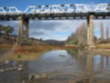
Tharwa Bridge
Tharwa Bridge
Tharwa Bridge is a four span Allan truss bridge which provides a high-level crossing point across the Murrumbidgee River, allowing traffic between Canberra and Tharwa village. It is the oldest surviving bridge in the Australian Capital Territory.- History :...
, opened on 27 March 1895, crosses the Murrumbidgee River
Murrumbidgee River
The Murrumbidgee River is a major river in the state of New South Wales, Australia, and the Australian Capital Territory . A major tributary of the Murray River, the Murrumbidgee flows in a west-northwesterly direction from the foot of Peppercorn Hill in the Fiery Range of the Snowy Mountains,...
. Tharwa Primary School
Tharwa Primary School
Tharwa Primary School was located in the small village of Tharwa, Australian Capital Territory. It was built in 1898 and opened in 1899. The school had two classrooms for the primary school, plus a preschool room. While the current school dates from 1912, the site of the school made it the oldest...
was opened soon after, in 1899. The Tharwa township narrowly avoided being burnt in the 2003 Canberra bushfires
2003 Canberra bushfires
The Canberra bushfires of 2003 caused severe damage to the outskirts of Canberra, the Australian capital city. Almost 70% of the Australian Capital Territory’s pasture, forests and nature parks were severely damaged, and most of the renowned Mount Stromlo Observatory was destroyed...
. The Tharwa community is currently facing two further challenges: closures and repairs to Tharwa Bridge due to extensive rot in its supporting timbers discovered in 2005 and the 2006-07 Australian Capital Territory budget
2006-07 Australian Capital Territory budget
The 2006-07 Australian Capital Territory budget for the financial year 2006-2007 was presented to the Australian Capital Territory Legislative Assembly by Chief Minister of the Australian Capital Territory Jon Stanhope on 6 June 2006...
announcement of its plans to close the Tharwa preschool and primary school at the end of 2006.
Tharwa Bridge was reopened for light traffic (less than 5 tonnes) in August 2008. Timber to further strengthen the bridge is currently being cured and work to reopen the bridge to heavy traffic should be complete by 2011.
Geology
Tharwa is in a different geological structural unit than the rest of Canberra, being on the Cotter Horst. The village itself is built on Tharwa Adamellite. This adamellite is coarsely foliated and contains biotiteBiotite
Biotite is a common phyllosilicate mineral within the mica group, with the approximate chemical formula . More generally, it refers to the dark mica series, primarily a solid-solution series between the iron-endmember annite, and the magnesium-endmember phlogopite; more aluminous endmembers...
mica
Mica
The mica group of sheet silicate minerals includes several closely related materials having highly perfect basal cleavage. All are monoclinic, with a tendency towards pseudohexagonal crystals, and are similar in chemical composition...
. It has been dated at 423 ±6 million years old. This places it in the upper Silurian age.
The outcrop area is extended to the north north west to Freshford, and includes Castle Hill. It goes as far to the west as Sawyer's Gully. To the south it goes close to Angle Crossing, and on the east side is bounded by the Murrumbidgee Fault. The Tharwa Adamellite is part of the Murrumbidgee Batholith.
The latitude and longitude of Tharwa is 35°31'00S 149°04'00E. The geoid
Geoid
The geoid is that equipotential surface which would coincide exactly with the mean ocean surface of the Earth, if the oceans were in equilibrium, at rest , and extended through the continents . According to C.F...
is 19.356 meters above the theoretical ellipsoid shape of the earth at Tharwa. The astronomical measurement of the position on the Earth's surface is only very slightly distorted by a non vertical gravitational field 0.3" to north and 0.6" to the west.
Magnetic declination
Magnetic declination
Magnetic declination is the angle between magnetic north and true north. The declination is positive when the magnetic north is east of true north. The term magnetic variation is a synonym, and is more often used in navigation...
at Tharwa is 11.817 deg east, total field strength is 43108 nT
and magnetic inclination is -66.031 degrees; as at 1 March 2006.
Declination is increasing by 0.004 degrees per year. Inclination is increasing by 0.016 degrees per year (as in the rest of Canberra).