
Texas State Highway 255
Encyclopedia
Texas
Texas is the second largest U.S. state by both area and population, and the largest state by area in the contiguous United States.The name, based on the Caddo word "Tejas" meaning "friends" or "allies", was applied by the Spanish to the Caddo themselves and to the region of their settlement in...
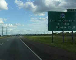
that has operated since 2000 that allows international traffic to bypass Laredo
Laredo, Texas
Laredo is the county seat of Webb County, Texas, United States, located on the north bank of the Rio Grande in South Texas, across from Nuevo Laredo, Tamaulipas, Mexico. According to the 2010 census, the city population was 236,091 making it the 3rd largest on the United States-Mexican border,...
. The route stretches from the Colombia Solidarity International Bridge to Interstate 35 at exit #24. It is one of the few operating toll roads in the United States
United States
The United States of America is a federal constitutional republic comprising fifty states and a federal district...
to have gone through the legal process of foreclosure
Foreclosure
Foreclosure is the legal process by which a mortgage lender , or other lien holder, obtains a termination of a mortgage borrower 's equitable right of redemption, either by court order or by operation of law...
.
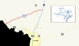
Route description
SH 255 begins at the Colombia Solidarity International Bridge on the United States-Mexico border northwest of LaredoLaredo, Texas
Laredo is the county seat of Webb County, Texas, United States, located on the north bank of the Rio Grande in South Texas, across from Nuevo Laredo, Tamaulipas, Mexico. According to the 2010 census, the city population was 236,091 making it the 3rd largest on the United States-Mexican border,...
in Webb County
Webb County, Texas
Webb County is a county located in the U.S. state of Texas. The official 2010 population for the county is 250,304. In 2000, its population was 193,117, and in 2006 its population had been estimated to have reached to 231,470. Its county seat is Laredo...
. It heads northeast from the border as a 4-lane divided highway to an intersection with FM 1472
Farm to Market Road 1472
Farm to Market Road 1472 is a farm-to-market road that connects the Laredo, Texas Industrial Area to the Colombia – Solidarity International Bridge, then running roughly parallel to the Rio Grande into rural Webb County...
. The highway continues to the northeast as a 4-lane divided highway but merges down to a 2-lane road just west of the former toll barrier. SH 255 continues northeast to an intersection at FM 3338
Farm to Market Road 3338
Farm to Market Road 3338 is a Farm to Market Road that connects the Laredo, Texas Industrial Area with rural Webb County. Its intersects State Highway 255 then turns into a gravel road.-Route description:...
and a diamond interchange
Diamond interchange
A diamond interchange is a common type of road junction, used where a freeway crosses a minor road. The freeway itself is grade-separated from the minor road, one crossing the other over a bridge...
with US 83. It continues to the northeast to its eastern terminus at I-35
Interstate 35 in Texas
Interstate 35 in Texas is a major north–south Interstate Highway running from Laredo near the United States-Mexico border to the Red River north of Gainesville where it crosses into Oklahoma. Along its route, it passes through the cities of San Antonio, Austin, and Waco before it splits into two...
.
Since June 1, 2009, use of the TxTag
TxTAG
TxTag , operated by the Texas Department of Transportation , is one of three interoperable electronic toll collection systems in Texas.-Current system status:The TxTag brand name is used on the following highways:* Operated by TxDOT:...
electronic toll collection system (or the interoperable EZ TAG
EZ TAG
EZ TAG is an electronic toll collection system in Houston, Texas, United States that allows motorists to pay tolls without stopping at toll booths. Motorists with the Tags are allowed to use lanes reserved exclusively for them on all Harris County Toll Road Authority roads...
and TollTag
TollTag
TollTag is the electronic toll collection system used by the North Texas Tollway Authority in the Dallas / Fort Worth metro area. It was North America’s first electronic toll collection system when it was installed on the Dallas North Tollway in 1989. There are currently over 2,000,000 TollTags in...
system) has been mandatory; unlike other TxDOT-operated toll roads, there is no pay-by-mail option. Laredo Trade Tags may also be used if they are tied to a TxTag account.
History
The route was originally approved in 1997 as a privately owned toll route for mainly truck traffic to bypass the city of Laredo for traffic congestion. The route was opened as the Camino Colombia Toll Road in October 2000, costing around $90 million.In August 2001, landowners that were shareholders of the route filed a lawsuit, claiming that profits and traffic usage were less than expected. The failure of the route was attributed to the price for truck traffic ($16), the continuation of U.S. government policies banning Mexican trucks from the interior of the United States (which had been expected to be abolished under the North American Free Trade Agreement
North American Free Trade Agreement
The North American Free Trade Agreement or NAFTA is an agreement signed by the governments of Canada, Mexico, and the United States, creating a trilateral trade bloc in North America. The agreement came into force on January 1, 1994. It superseded the Canada – United States Free Trade Agreement...
), and the approval of a new freeway connecting route from the World Trade International Bridge
World Trade International Bridge
The World Trade International Bridge is one of 4 international bridges located in the cities of Laredo, Texas, and Nuevo Laredo, Tamaulipas, that connect the United States and Mexico over the Rio Grande . It is owned and operated by City of Laredo and the Secretaría de Comunicaciones y...
crossing along Loop 20 to Interstate 35.
The toll road was foreclosed on late in 2003, and was auctioned off on the steps of the Webb County
Webb County, Texas
Webb County is a county located in the U.S. state of Texas. The official 2010 population for the county is 250,304. In 2000, its population was 193,117, and in 2006 its population had been estimated to have reached to 231,470. Its county seat is Laredo...
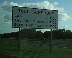
courthouse January 6, 2004. It was purchased by its main creditor, the John Hancock Life Insurance Company, for the minimum $12 million, 1/6 of the construction value. The only other bidder was the Texas Department of Transportation at $11 million. The route was subsequently closed to all traffic. In May 2004, TxDOT purchased the route from John Hancock for a negotiated $20 million, and reopened the route in September, dropping the toll to $2 toll for cars and $2 per additional axle.
SH 255 inherited its number from FM 255, which was designated on the route between the border crossing and in 1989. The SH 255 designation was extended over this segment in 2005.
Previous route
A previous route existed with the SH 255 designation, beginning in BremondBremond, Texas
Bremond is a city in Robertson County, Texas, United States. The population was 876 at the 2000 census. It is part of the Bryan-College Station metropolitan area.-History:...
and traveling southeast to Bryan
Bryan, Texas
Bryan is a city in Brazos County, Texas, United States. As of the 2010 census, the city had a total population of 76,201. It is the county seat of Brazos County and is located in the heart of the Brazos Valley . It shares its border with the city of College Station, which lies to its south...
. This route became by 1942.
Major intersections
| County | Location | Mile | Junction | Notes |
|---|---|---|---|---|
| Webb Webb County, Texas Webb County is a county located in the U.S. state of Texas. The official 2010 population for the county is 250,304. In 2000, its population was 193,117, and in 2006 its population had been estimated to have reached to 231,470. Its county seat is Laredo... |
United States-Mexico border at the Colombia Solidarity International Bridge | |||
| Toll Gantry | ||||
| Interchange | ||||
| Interchange | ||||