Territorial evolution of Australia
Encyclopedia
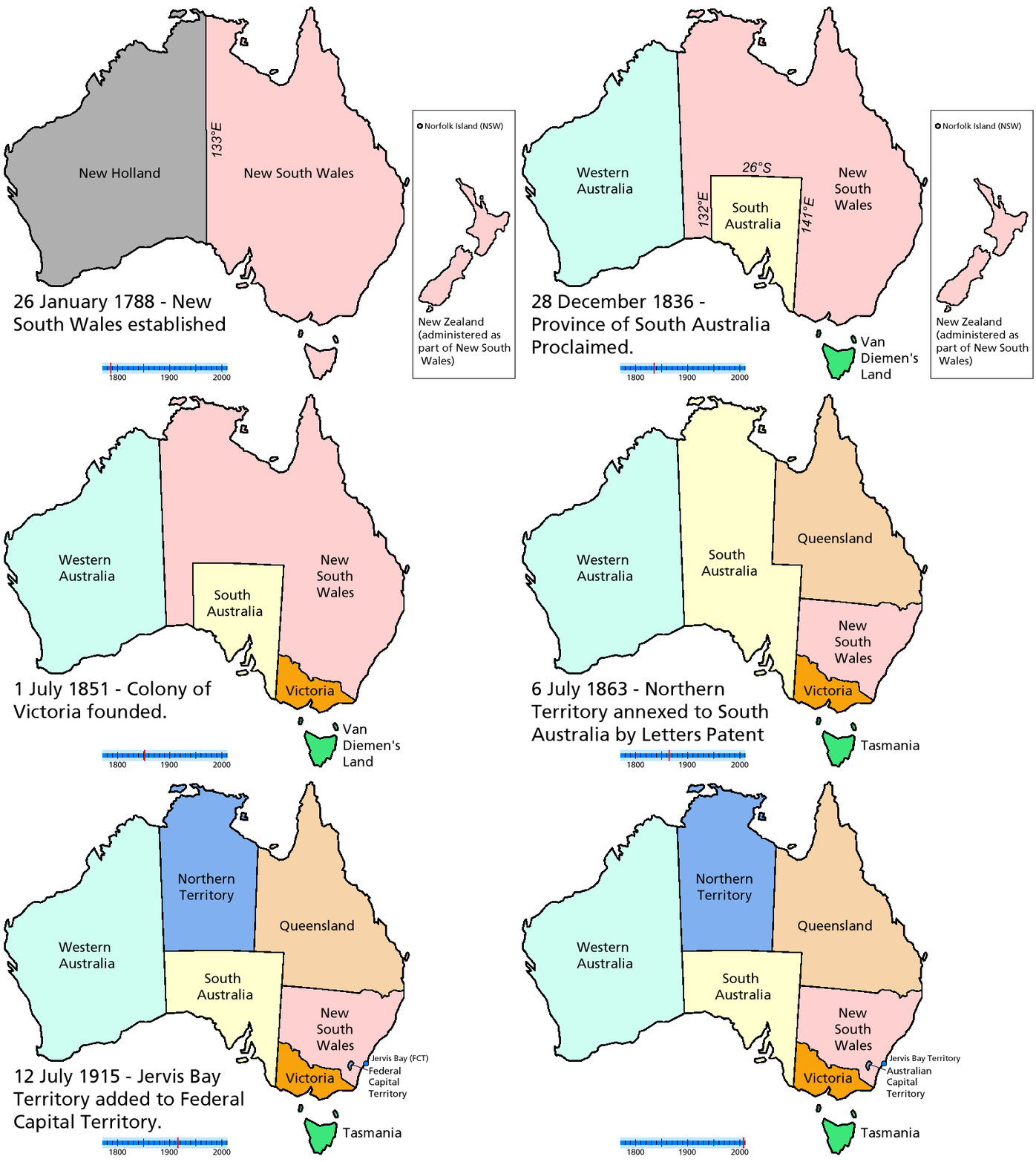
This is a list of the evolution of the borders of the colonies and later states of Australia
. It lists each change to the internal and external borders of Australia before and after Federation.
26 January 1788
16 July 1825
3 December 1825
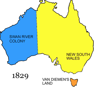
2 May 1829
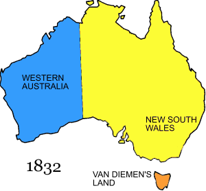
6 February 1832
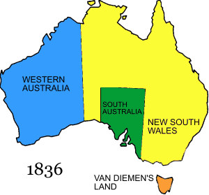
28 December 1836
21 May 1840
16 November 1840
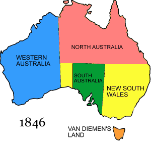
17 February 1846
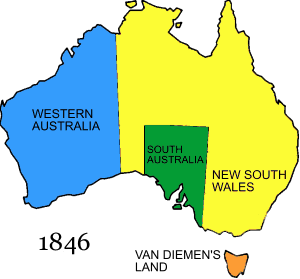
15 April 1847
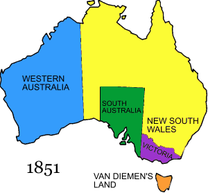
1 July 1851
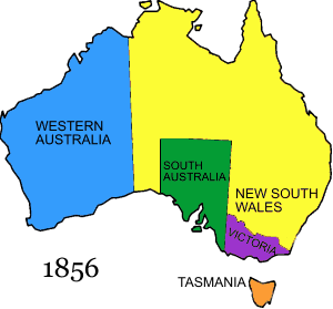
1 January 1856

6 June 1859
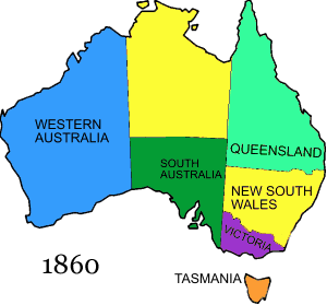
1860
1862

6 July 1863

1 January 1901
1 January 1911
12 July 1915
1 March 1927
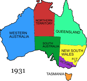
12 June 1931
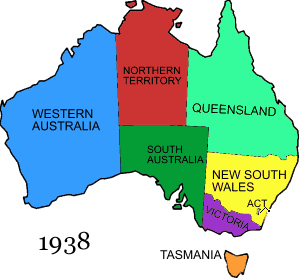
29 July 1938
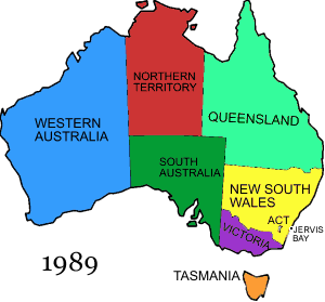
11 May 1989
23 July 1931
13 June 1933
26 June 1947
23 November 1955
1 October 1958
30 September 1969
Australia
Australia , officially the Commonwealth of Australia, is a country in the Southern Hemisphere comprising the mainland of the Australian continent, the island of Tasmania, and numerous smaller islands in the Indian and Pacific Oceans. It is the world's sixth-largest country by total area...
. It lists each change to the internal and external borders of Australia before and after Federation.

Pre-Federation

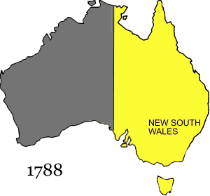
26 January 1788
- The colony of New South WalesNew South WalesNew South Wales is a state of :Australia, located in the east of the country. It is bordered by Queensland, Victoria and South Australia to the north, south and west respectively. To the east, the state is bordered by the Tasman Sea, which forms part of the Pacific Ocean. New South Wales...
is founded. New South Wales, according to Arthur Phillip's amended Commission dated 25 April 1787, includes "all the islands adjacent in the Pacific Ocean" and running westward to the 135th meridian east135th meridian eastThe meridian 135° east of Greenwich is a line of longitude that extends from the North Pole across the Arctic Ocean, Asia, the Pacific Ocean, Australasia, the Indian Ocean, the Southern Ocean, and Antarctica to the South Pole....
. This included the islands of New ZealandNew ZealandNew Zealand is an island country in the south-western Pacific Ocean comprising two main landmasses and numerous smaller islands. The country is situated some east of Australia across the Tasman Sea, and roughly south of the Pacific island nations of New Caledonia, Fiji, and Tonga...
.

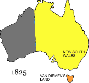
16 July 1825
- New South Wales' western border is extended to 129° E.
3 December 1825
- The colony of Van Diemen's LandVan Diemen's LandVan Diemen's Land was the original name used by most Europeans for the island of Tasmania, now part of Australia. The Dutch explorer Abel Tasman was the first European to land on the shores of Tasmania...
is proclaimed.

2 May 1829
- Swan River ColonySwan River ColonyThe Swan River Colony was a British settlement established in 1829 on the Swan River, in Western Australia. The name was a pars pro toto for Western Australia. In 1832, the colony was officially renamed Western Australia, when the colony's founding Lieutenant-Governor, Captain James Stirling,...
is declared by Charles FremantleCharles FremantleAdmiral Sir Charles Howe Fremantle GCB RN was a British Royal Navy officer. The city of Fremantle in Western Australia is named after him.-Early life:...
for Britain.

6 February 1832
- Swan River Colony has its name changed to Western AustraliaWestern AustraliaWestern Australia is a state of Australia, occupying the entire western third of the Australian continent. It is bounded by the Indian Ocean to the north and west, the Great Australian Bight and Indian Ocean to the south, the Northern Territory to the north-east and South Australia to the south-east...
.

28 December 1836
- The colony of South AustraliaSouth AustraliaSouth Australia is a state of Australia in the southern central part of the country. It covers some of the most arid parts of the continent; with a total land area of , it is the fourth largest of Australia's six states and two territories.South Australia shares borders with all of the mainland...
is proclaimed with its western border set at 132° E.
21 May 1840
- New ZealandNew ZealandNew Zealand is an island country in the south-western Pacific Ocean comprising two main landmasses and numerous smaller islands. The country is situated some east of Australia across the Tasman Sea, and roughly south of the Pacific island nations of New Caledonia, Fiji, and Tonga...
is formally annexed to New South Wales.
16 November 1840
- The colony of New Zealand is proclaimed by Letters Patent. Although not represented on a map here, New South Wales was significantly reduced in size by this proclamation. Separation was effected on 3 May 1841

17 February 1846
- The colony of North AustraliaNorth AustraliaNorth Australia can refer to a former territory, a former colony or a proposed state which would replace the current Northern Territory.-Colony :...
was proclaimed by Letters Patent on 17 February. This was all of New South Wales north of 26° S.

15 April 1847
- The colony of North Australia was revoked and reincorporated into New South Wales

1 July 1851
- The colony of VictoriaVictoria (Australia)Victoria is the second most populous state in Australia. Geographically the smallest mainland state, Victoria is bordered by New South Wales, South Australia, and Tasmania on Boundary Islet to the north, west and south respectively....
is proclaimed.

1 January 1856
- Van Diemen's Land name is changed to TasmaniaTasmaniaTasmania is an Australian island and state. It is south of the continent, separated by Bass Strait. The state includes the island of Tasmania—the 26th largest island in the world—and the surrounding islands. The state has a population of 507,626 , of whom almost half reside in the greater Hobart...
.

6 June 1859
- The colony of QueenslandQueenslandQueensland is a state of Australia, occupying the north-eastern section of the mainland continent. It is bordered by the Northern Territory, South Australia and New South Wales to the west, south-west and south respectively. To the east, Queensland is bordered by the Coral Sea and Pacific Ocean...
is proclaimed by Letters Patent, with its western border set at 141° E, and settlement began on 10 December that year.

1860
- South Australia border changed from 132° E to 129° E.

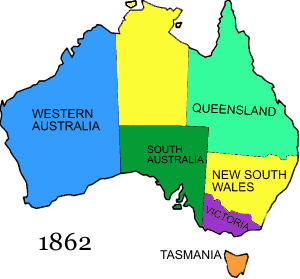
1862
- Queensland's western border is moved to 139° E.

6 July 1863
- That part of New South Wales to the north of South Australia was annexed to South Australia by Letters Patent.
Post-Federation

1 January 1901
- The Commonwealth of Australia was formedFederation of AustraliaThe Federation of Australia was the process by which the six separate British self-governing colonies of New South Wales, Queensland, South Australia, Tasmania, Victoria and Western Australia formed one nation...
, uniting the BritishUnited KingdomThe United Kingdom of Great Britain and Northern IrelandIn the United Kingdom and Dependencies, other languages have been officially recognised as legitimate autochthonous languages under the European Charter for Regional or Minority Languages...
colonies of New South WalesNew South WalesNew South Wales is a state of :Australia, located in the east of the country. It is bordered by Queensland, Victoria and South Australia to the north, south and west respectively. To the east, the state is bordered by the Tasman Sea, which forms part of the Pacific Ocean. New South Wales...
, QueenslandQueenslandQueensland is a state of Australia, occupying the north-eastern section of the mainland continent. It is bordered by the Northern Territory, South Australia and New South Wales to the west, south-west and south respectively. To the east, Queensland is bordered by the Coral Sea and Pacific Ocean...
, South AustraliaSouth AustraliaSouth Australia is a state of Australia in the southern central part of the country. It covers some of the most arid parts of the continent; with a total land area of , it is the fourth largest of Australia's six states and two territories.South Australia shares borders with all of the mainland...
, TasmaniaTasmaniaTasmania is an Australian island and state. It is south of the continent, separated by Bass Strait. The state includes the island of Tasmania—the 26th largest island in the world—and the surrounding islands. The state has a population of 507,626 , of whom almost half reside in the greater Hobart...
, VictoriaVictoria (Australia)Victoria is the second most populous state in Australia. Geographically the smallest mainland state, Victoria is bordered by New South Wales, South Australia, and Tasmania on Boundary Islet to the north, west and south respectively....
, and Western AustraliaWestern AustraliaWestern Australia is a state of Australia, occupying the entire western third of the Australian continent. It is bounded by the Indian Ocean to the north and west, the Great Australian Bight and Indian Ocean to the south, the Northern Territory to the north-east and South Australia to the south-east...
. Note that the Northern TerritoryNorthern TerritoryThe Northern Territory is a federal territory of Australia, occupying much of the centre of the mainland continent, as well as the central northern regions...
was under South Australian administration at Federation.

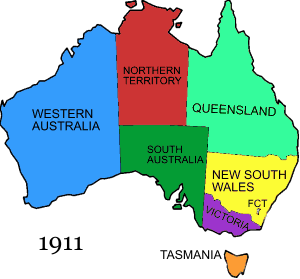
1 January 1911
- The Federal Capital TerritoryAustralian Capital TerritoryThe Australian Capital Territory, often abbreviated ACT, is the capital territory of the Commonwealth of Australia and is the smallest self-governing internal territory...
was created within New South Wales, and the Northern Territory was split off from South Australia.

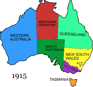
12 July 1915
- The coastal area now known as the Jervis Bay TerritoryJervis Bay TerritoryThe Jervis Bay Territory is a territory of the Commonwealth of Australia. It was surrendered by the state of New South Wales to the Commonwealth Government in 1915 so that the Federal capital at Canberra would have "access to the sea"....
is added to the Federal Capital Territory.

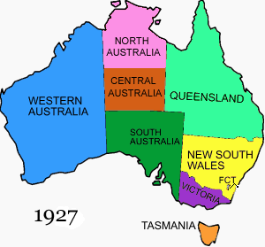
1 March 1927
- The Northern Territory was split into the territories of North AustraliaNorth AustraliaNorth Australia can refer to a former territory, a former colony or a proposed state which would replace the current Northern Territory.-Colony :...
and Central AustraliaCentral AustraliaCentral Australia/Alice Springs Region is one of the five regions in the Northern Territory. The term Central Australia is used to describe an area centred on Alice Springs in Australia. It is sometimes referred to as Centralia; likewise the people of the area are sometimes called Centralians...
.

12 June 1931
- North Australia and Central Australia were reunited as the Northern Territory.

29 July 1938
- The Federal Capital Territory's name is changed to the Australian Capital TerritoryAustralian Capital TerritoryThe Australian Capital Territory, often abbreviated ACT, is the capital territory of the Commonwealth of Australia and is the smallest self-governing internal territory...
.

11 May 1989
- The Jervis Bay TerritoryJervis Bay TerritoryThe Jervis Bay Territory is a territory of the Commonwealth of Australia. It was surrendered by the state of New South Wales to the Commonwealth Government in 1915 so that the Federal capital at Canberra would have "access to the sea"....
becomes Australia's third mainland territory when the Australian Capital Territory is granted self government.
External Territories
1 July 1914- Norfolk IslandNorfolk IslandNorfolk Island is a small island in the Pacific Ocean located between Australia, New Zealand and New Caledonia. The island is part of the Commonwealth of Australia, but it enjoys a large degree of self-governance...
is transferred from New South Wales to the Commonwealth of Australia
23 July 1931
- Ashmore Island and the Cartier IslandsCartier IslandsCartier Island is an uninhabited and unvegetated sand cay in a platform reef in the Timor Sea north of Australia and south of Indonesia. It is located at 12°31'S 123°33'E, on the edge of the Sahul Shelf, about 300 kilometres off the north west coast of Western Australia, 200 kilometres south of the...
are transferred from Britain to Australia
13 June 1933
- The Australian Antarctic TerritoryAustralian Antarctic TerritoryThe Australian Antarctic Territory is a part of Antarctica. It was claimed by the United Kingdom and placed under the authority of the Commonwealth of Australia in 1933. It is the largest territory of Antarctica claimed by any nation...
is transferred from Britain
26 June 1947
- Heard Island and the McDonald Islands are transferred from Britain
23 November 1955
- The Cocos (Keeling) IslandsCocos (Keeling) IslandsThe Territory of the Cocos Islands, also called Cocos Islands and Keeling Islands, is a territory of Australia, located in the Indian Ocean, southwest of Christmas Island and approximately midway between Australia and Sri Lanka....
are transferred from Singapore to Australia
1 October 1958
- Christmas IslandChristmas IslandThe Territory of Christmas Island is a territory of Australia in the Indian Ocean. It is located northwest of the Western Australian city of Perth, south of the Indonesian capital, Jakarta, and ENE of the Cocos Islands....
is transferred from Britain
30 September 1969
- The Coral Sea Islands Territory is transferred from Queensland to the Commonwealth of Australia
Former External Territories
- Territory of Papua (1906-42)
- Territory of New GuineaTerritory of New GuineaThe Territory of New Guinea was the Australia-controlled, League of Nations-mandated territory in the north eastern part of the island of New Guinea, and surrounding islands, between 1920 and 1949...
(1920-42) - Territory of NauruNauruNauru , officially the Republic of Nauru and formerly known as Pleasant Island, is an island country in Micronesia in the South Pacific. Its nearest neighbour is Banaba Island in Kiribati, to the east. Nauru is the world's smallest republic, covering just...
(1920-68) - Territory of Papua and New GuineaTerritory of Papua and New GuineaThe Territory of Papua and New Guinea was established by an administrative union between the Australian-administered territories of Papua and New Guinea in 1949...
(1942-71) - Territory of Papua New GuineaPapua New GuineaPapua New Guinea , officially the Independent State of Papua New Guinea, is a country in Oceania, occupying the eastern half of the island of New Guinea and numerous offshore islands...
(1971-75)

