

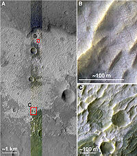
Terra Sirenum
Encyclopedia
Southern Hemisphere
The Southern Hemisphere is the part of Earth that lies south of the equator. The word hemisphere literally means 'half ball' or "half sphere"...
of the planet Mars
Mars
Mars is the fourth planet from the Sun in the Solar System. The planet is named after the Roman god of war, Mars. It is often described as the "Red Planet", as the iron oxide prevalent on its surface gives it a reddish appearance...
. It is centered at 39.7°S 150°W and covers 3900 km at its broadest extent. It covers latitudes 10 to 70 South and longitudes 110 to 180 W. Terra Sirenum is an upland area notable for massive cratering
Impact crater
In the broadest sense, the term impact crater can be applied to any depression, natural or manmade, resulting from the high velocity impact of a projectile with a larger body...
including the large Newton Crater
Newton (Martian crater)
Newton is a large crater on Mars, with a diameter close to 300 km. It is located south of the planet's equator in the heavily cratered highlands of Terra Sirenum. The impact that formed Newton likely occurred more than 3 billion years ago...
. Terra Sirenum is in the Phaethontis quadrangle
Phaethontis quadrangle
The Phaethontis quadrangle is one of a series of 30 quadrangle maps of Mars used by the United States Geological Survey Astrogeology Research Program. The Phaethontis quadrangle is also referred to as MC-24 ....
of Mars. A low area in Terra Sirenum is believed to have once held a lake that eventually drained through Ma'adim Vallis
Ma'adim Vallis
Ma'adim Vallis is one of the largest outflow channels on Mars, about 700 km long and significantly larger than Earth's Grand Canyon. It is over 20 km wide and 2 km deep in some places. It runs from a region of southern lowlands thought to have once contained a large group of lakes ...
.
Chloride Deposits
Evidence of deposits of chlorideChloride
The chloride ion is formed when the element chlorine, a halogen, picks up one electron to form an anion Cl−. The salts of hydrochloric acid HCl contain chloride ions and can also be called chlorides. The chloride ion, and its salts such as sodium chloride, are very soluble in water...
based minerals in Terra Sirenum was discovered by the 2001 Mars Odyssey
2001 Mars Odyssey
2001 Mars Odyssey is a robotic spacecraft orbiting the planet Mars. The project was developed by NASA, and contracted out to Lockheed Martin, with an expected cost for the entire mission of US$297 million. Its mission is to use spectrometers and electronic imagers to hunt for evidence of past or...
orbiter in March 2008. The deposits are approximately 3.5 to 3.9 billion years old. This suggests that near-surface water was widespread in early Martian history, which has implications for the possible existence of Martian life
Life on Mars
Scientists have long speculated about the possibility of life on Mars owing to the planet's proximity and similarity to Earth. Fictional Martians have been a recurring feature of popular entertainment of the 20th and 21st centuries, but it remains an open question whether life currently exists on...
. Besides finding chlorides, MRO
MRO
-Operations:* maintenance, repair, and operations -Companies:...
discovered iron/magnesium smectites which are formed from long exposure in water.
Inverted Relief
Some areas of Mars show inverted reliefInverted Relief
Inverted relief is a landscape that is part of a planet's surface, e.g. Mars, that contains positive landforms, i.e. hills and ridges, that were once depressions in its surface...
, where features that were once depressions, like streams, are now above the surface. It is believed that materials like large rocks were deposited in low-lying areas. Later, erosion (perhaps wind which can't move large rocks) removed much of the surface layers, but left behind the more resistant deposits. Other ways of making inverted relief might be lava flowing down a stream bed or materials being cemented by minerals dissolved in water. On Earth, materials cemented by silica are highly resistant to all kinds of erosional forces. Examples of inverted channels on Earth are found in the Cedar Mountain Formation near Green River, Utah
Utah
Utah is a state in the Western United States. It was the 45th state to join the Union, on January 4, 1896. Approximately 80% of Utah's 2,763,885 people live along the Wasatch Front, centering on Salt Lake City. This leaves vast expanses of the state nearly uninhabited, making the population the...
. Inverted relief in the shape of streams are further evidence of water flowing on the Martian surface in past times.
Martian Gullies
Terra SirenumTerra Sirenum
Terra Sirenum is a large region in the southern hemisphere of the planet Mars. It is centered at and covers 3900 km at its broadest extent. It covers latitudes 10 to 70 South and longitudes 110 to 180 W. Terra Sirenum is an upland area notable for massive cratering including the large Newton...
is the location of many martian gullies
Martian Gullies
First discovered on images from Mars Global Surveyor, Martian gullies may be the site of recent liquid water. Gullies occur on steep slopes, especially on the walls of craters. Gullies are believed to be relatively young because they have few, if any craters. Moreover, they lie on top of sand...
that may be due to recent flowing water. Some are found in the Gorgonum Chaos
Gorgonum Chaos
Gorgonum Chaos is a set of canyons in the Phaethontis quadrangle of Mars. It is located at37.5° south latitude and 170.9° west longitude. Its name comes from an albedo feature at 24S, 154W.- Gullies :...
and in many craters near the large craters Copernicus and Newton (Martian crater)
Newton (Martian crater)
Newton is a large crater on Mars, with a diameter close to 300 km. It is located south of the planet's equator in the heavily cratered highlands of Terra Sirenum. The impact that formed Newton likely occurred more than 3 billion years ago...
. Gullies occur on steep slopes, especially on the walls of craters. Gullies are believed to be relatively young because they have few, if any craters. Moreover, they lie on top of sand dunes which themselves are considered to be quite young. Usually, each gully has an alcove, channel, and apron. Some studies have found that gullies occur on slopes that face all directions, others have found that the greater number of gullies are found on poleward facing slopes, especially from 30-44 S.
Although many ideas have been put forward to explain them, the most popular involve liquid water coming from an aquifer
Aquifer
An aquifer is a wet underground layer of water-bearing permeable rock or unconsolidated materials from which groundwater can be usefully extracted using a water well. The study of water flow in aquifers and the characterization of aquifers is called hydrogeology...
, from melting at the base of old glaciers, or from the melting of ice in the ground when the climate was warmer. Because of the good possibility that liquid water was involved with their formation and that they could be very young, scientists are excited. Maybe the gullies are where we should go to find life.
There is evidence for all three theories. Most of the gully alcove heads occur at the same level, just as one would expect of an aquifer
Aquifer
An aquifer is a wet underground layer of water-bearing permeable rock or unconsolidated materials from which groundwater can be usefully extracted using a water well. The study of water flow in aquifers and the characterization of aquifers is called hydrogeology...
. Various measurements and calculations show that liquid water could exist in aquifers at the usual depths where gullies begin. One variation of this model is that rising hot magma
Magma
Magma is a mixture of molten rock, volatiles and solids that is found beneath the surface of the Earth, and is expected to exist on other terrestrial planets. Besides molten rock, magma may also contain suspended crystals and dissolved gas and sometimes also gas bubbles. Magma often collects in...
could have melted ice in the ground and caused water to flow in aquifers. Aquifers are layer that allow water to flow. They may consist of porous sandstone. The aquifer layer would be perched on top of another layer that prevents water from going down (in geological terms it would be called impermeable). Because water in an aquifer is prevented from going down, the only direction the trapped water can flow is horizontally. Eventually, water could flow out onto the surface when the aquifer reaches a break—like a crater wall. The resulting flow of water could erode the wall to create gullies. Aquifers are quite common on Earth. A good example is "Weeping Rock" in Zion National Park
Zion National Park
Zion National Park is located in the Southwestern United States, near Springdale, Utah. A prominent feature of the park is Zion Canyon, which is 15 miles long and up to half a mile deep, cut through the reddish and tan-colored Navajo Sandstone by the North Fork of the Virgin River...
Utah
Utah
Utah is a state in the Western United States. It was the 45th state to join the Union, on January 4, 1896. Approximately 80% of Utah's 2,763,885 people live along the Wasatch Front, centering on Salt Lake City. This leaves vast expanses of the state nearly uninhabited, making the population the...
.
As for the next theory, much of the surface of Mars is covered by a thick smooth mantle that is thought to be a mixture of ice and dust. This ice-rich mantle, a few yards thick, smoothes the land, but in places it has a bumpy texture, resembling the surface of a basketball. The mantle may be like a glacier and under certain conditions the ice that is mixed in the mantle could melt and flow down the slopes and make gullies. Because there are few craters on this mantle, the mantle is relatively young. An excellent view of this mantle is shown below in the picture of the Ptolemaeus Crater Rim, as seen by HiRISE
HiRISE
High Resolution Imaging Science Experiment is a camera on board the Mars Reconnaissance Orbiter. The 65 kg , $40 million instrument was built under the direction of the University of Arizona's Lunar and Planetary Laboratory by Ball Aerospace & Technologies Corp....
.
The ice-rich mantle may be the result of climate changes. Changes in Mars's orbit and tilt cause significant changes in the distribution of water ice from polar regions down to latitudes equivalent to Texas. During certain climate periods water vapor leaves polar ice and enters the atmosphere. The water comes back to ground at lower latitudes as deposits of frost or snow mixed generously with dust. The atmosphere of Mars contains a great deal of fine dust particles. Water vapor will condense on the particles, then fall down to the ground due to the additional weight of the water coating. When Mars is at its greatest tilt or obliquity, up to 2 cm of ice could be removed from the summer ice cap and deposited at midlatitudes. This movement of water could last for several thousand years and create a snow layer of up to around 10 meters thick. When ice at the top of the mantling layer goes back into the atmosphere, it leaves behind dust, which insulating the remaining ice. Measurements of altitudes and slopes of gullies support the idea that snowpacks or glaciers are associated with gullies. Steeper slopes have more shade which would preserve snow.
Higher elevations have far fewer gullies because ice would tend to sublimate more in the thin air of the higher altitude.
The third theory might be possible since climate changes may be enough to simply allow ice in the ground to melt and thus form the gullies. During a warmer climate, the first few meters of ground could thaw and produce a "debris flow" similar to those on the dry and cold Greenland east coast. Since the gullies occur on steep slopes only a small decrease of the shear strength of the soil particles is needed to begin the flow. Small amounts of liquid water from melted ground ice could be enough. Calculations show that a third of a mm of runoff can be produced each day for 50 days of each Martian year, even under current conditions.
Magnetic Stripes and Plate Tectonics
The Mars Global SurveyorMars Global Surveyor
The Mars Global Surveyor was a US spacecraft developed by NASA's Jet Propulsion Laboratory and launched November 1996. It began the United States's return to Mars after a 10-year absence. It completed its primary mission in January 2001 and was in its third extended mission phase when, on 2...
(MGS) discovered magnetic stripes in the crust of Mars, especially in the Phaethontis and Eridania quadrangle
Eridania quadrangle
The Eridania quadrangle is one of a series of 30 quadrangle maps of Mars used by the United States Geological Survey Astrogeology Research Program. The Eridania quadrangle is also referred to as MC-29 ....
s (Terra Cimmeria
Terra Cimmeria
Terra Cimmeria is a large Martian region, centered at and covering 5400 km at its broadest extent. It covers latitudes 15 N to 75 S and longitudes 170 to 260 W. Terra Cimmeria is one part of the heavily cratered, southern highland region of the planet...
and Terra Sirenum). The magnetometer on MGS discovered 100 km wide stripes of magnetized crust running roughly parallel for up to 2000 km. These stripes alternate in polarity with the north magnetic pole of one pointing up from the surface and the north magnetic pole of the next pointing down. When similar stripes were discovered on Earth in the 1960s, they were taken as evidence of plate tectonics
Plate tectonics
Plate tectonics is a scientific theory that describes the large scale motions of Earth's lithosphere...
. Researchers believe these magnetic stripes on Mars are evidence for an short, early period of plate tectonic activity. When the rocks became solid they retained the magnetism that existed at the time. A magnetic field of a planet is believed to be caused by fluid motions under the surface. However, there are some differences, between the magnetic stripes on Earth and those on Mars. The Martian stripes are wider, much more strongly magnetized, and do not appear to spread out from a middle crustal spreading zone.
Because the area containing the magnetic stripes is about 4 billion years old, it is believed that the global magnetic field probably lasted for only the first few hundred million years of Mars' life, when the temperature of the molten iron in the planet's core might have been high enough to mix it into a magnetic dynamo. There are no magnetic fields near large impact basins like Hellas. The shock of the impact may have erased the remnant magnetization in the rock. So, magnetism produced by early fluid motion in the core would not have existed after the impacts.
When molten rock containing magnetic material, such as hematite
Hematite
Hematite, also spelled as haematite, is the mineral form of iron oxide , one of several iron oxides. Hematite crystallizes in the rhombohedral system, and it has the same crystal structure as ilmenite and corundum...
(Fe2O3), cools and solidifies in the presence of a magnetic field, it becomes magnetized and takes on the polarity of the background field. This magnetism is lost only if the rock is subsequently heated above a particular temperature (the Curie point which is 770°C for iron). The magnetism left in rocks is a record of the magnetic field when the rock solidified.