
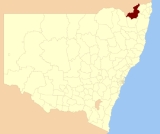
Tenterfield Shire Council
Encyclopedia
.jpg)
New England (Australia)
New England or New England North West is the name given to a generally undefined region about 60 kilometres inland, that includes the Northern Tablelands and the North West Slopes regions in the north of the state of New South Wales, Australia.-History:The region has been occupied by Indigenous...
region of New South Wales
New South Wales
New South Wales is a state of :Australia, located in the east of the country. It is bordered by Queensland, Victoria and South Australia to the north, south and west respectively. To the east, the state is bordered by the Tasman Sea, which forms part of the Pacific Ocean. New South Wales...
, Australia
Australia
Australia , officially the Commonwealth of Australia, is a country in the Southern Hemisphere comprising the mainland of the Australian continent, the island of Tasmania, and numerous smaller islands in the Indian and Pacific Oceans. It is the world's sixth-largest country by total area...
, located along the New England Highway
New England Highway
The New England Highway is a highway in Australia running from Hexham near Newcastle at its southern end to Yarraman near Toowoomba at its northern end. At its southern end it connects to the Pacific Highway and at its northern end it connects to the D'Aguilar Highway. It traverses the Hunter...
.
Demographics
According to the Australian Bureau Statistics , there:- were 6,909 people as at 30 June 2006, the 117th largest Local Government Area in New South Wales. It was equal to 0.1% of the New South Wales population of 6,827,694
- was an increase of 87 people over the year to 30 June 2006, the 90th largest population growth in a Local Government Area in New South Wales. It was equal to 0.1% of the 58,753 increase in the population of New South Wales
- was, in percentage terms, an increase of 1.3% in the number of people over the year to 30 June 2006, the 32nd fastest growth in population of a Local Government Area in New South Wales. In New South Wales the population grew by 0.9%
- was an increase in population over the 10 years to 30 June 2006 of 229 people or 3.4% (0.3% in annual average terms), the 84th highest rate of a Local Government Area in New South Wales. In New South Wales the population grew by 622,966 or 10% (1.0% in annual average terms) over the same period.
Incomes
According to the Australian Bureau Statistics during 2003-04, there:- were 1,663 wage and salary earners (ranked 124th in New South Wales and 403rd in Australia, 0.1% of New South Wales's 2,558,415 and less tan 0.1% of Australia's 7,831,856)
- was a total income of $49,374,607 (around $49 million) (ranked 126th in New South Wales and 410th in Australia, less than 0.1% of New South Wales's $107,179,688,262 (around $107 billion) and less than 0.1% of Australia's $304,034,755,876 (around $304 billion))
- was an estimated average
Average
In mathematics, an average, or central tendency of a data set is a measure of the "middle" value of the data set. Average is one form of central tendency. Not all central tendencies should be considered definitions of average....
income per wage and salary earner of $29,690 (ranked 161st in New South Wales and 539th in Australia, 72% of New South Wales's $41,407 and 76% of Australia's $38,820)
- was an estimated median
Median
In probability theory and statistics, a median is described as the numerical value separating the higher half of a sample, a population, or a probability distribution, from the lower half. The median of a finite list of numbers can be found by arranging all the observations from lowest value to...
income per wage and salary earner of $27,824 (ranked 150th in New South Wales and 503rd in Australia, 78% of New South Wales's $35,479 and 81% of Australia's $34,149).
Main towns, villages and localities
The Shire includes the town of TenterfieldTenterfield, New South Wales
Tenterfield is a town in New South Wales, Australia. It is located in the New England region at the intersection of the New England and Bruxner Highways. Tenterfield is a three-hour drive from Brisbane, 2.5 hours from Byron Bay, two hours from Armidale, New South Wales and 10 hours from Sydney....
and villages including Drake, Jennings
Jennings, New South Wales
Jennings is a town on the Northern Tablelands region of New South Wales, Australia. The town is located in the Tenterfield Shire Local Government Area, from the state capital, Sydney and from Brisbane. It is separated by the state border from its neighbouring town of Wallangarra in Queensland. ...
, Liston, Legume, Bolivia
Bolivia, New South Wales
Bolivia is a locality on the Northern Tablelands in the New England region of New South Wales, Australia. The remains of the settlement comprises the former Bolivia Hotel, a disused post office, a disused railway siding and a community hall.- History :...
, Sandy Flat
Sandy Flat, New South Wales
Sandy Flat is an historic locality on the Northern Tablelands in the New England region of New South Wales, Australia. This locality is situated on New England Highway and the former Main North Railway line about 20 kilometres south of Tenterfield. At the 2006 census, Sandy Flat had a population...
, Stannum
Stannum, New South Wales
Stannum is a small tin mining village on the Northern Tablelands, in the New England region of New South Wales, Australia. The region is in Tenterfield Shire. It is 14 kilometres north north-west of Deepwater and south-west of Tenterfield and 48 kilometres from Glen Innes...
, Torrington
Torrington, New South Wales
Torrington is a small village in northern New South Wales in Tenterfield Shire. It is 29 kilometres north west of Deepwater and south west of Tenterfield and 61 kilometres from Glen Innes . It is situated on a plateau known as the Mole Tableland in close proximity to the Queensland...
, Urbenville
Urbenville, New South Wales
Urbenville is a rural village in northern New South Wales, Australia. The village is located in the Tenterfield Shire Local Government Area, north of the state capital, Sydney, and south west of Brisbane. At the 2006 census, Urbenville had a population of 245.The bank in the small town is...
and Mingoola.